|
|
General: ADAM SMITH, EL CAPITALISMO Y SU NEXO CON MARIA LA MAGDALENA
Elegir otro panel de mensajes |
|
|
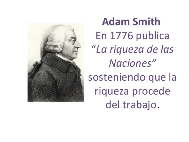
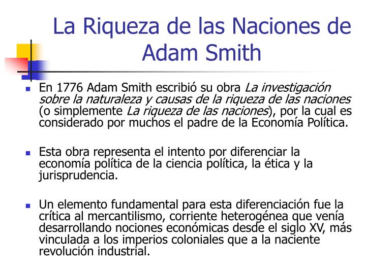
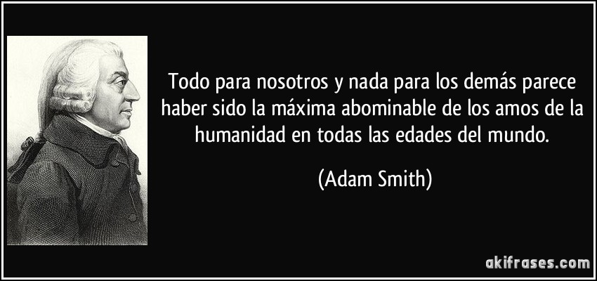
 Aqui tenemos a Pi - la circunferencia del toro y la vesica piscis 256/153 equivalente a la raiz cuadrada de 3 En el hipercubo las coordinadas binarias de Piscis son decimal 3 y binario 11 153 los pescados de Jesus en la biblia
|
|
|
|
|
The region has a beautiful landscape and visitors find in Magdalena a lot of things to see and to do. They can go to the beach along the coast of Rio de La Plata and spend a day off. They can have a beach day, they can swim, play beach volley ball, frisbee or just relax and read a book. Its coasts and the river also offer fishermen the chance of excellent fishing. The Parque Costero del Sur was declared World Heritage Site ( Reserva mundial de Biosfera) by UNESCO in 1984. It is situated along the coast of the Rio de La Plata, between Magdalena and Punta de Indio and this coastal area is 70 km long and 5 km wide.
The most popular trees are the Talas. It is one of the main components of this area. The Tala is a medium to large sized tree sometimes reaching 12 m high. This tree flowers in spring. Ceramics forms known as “tubular potteries” have been found in Magdalena and Punta de Indio, near the river. The peculiarity of such ceramics is their morphology with two open ends. This lively agricultural and commercial centre has a splendid historic centre, which has remained almost intact. Built near the Rio de La Plata, it had strategic importance some time ago. Visitors have to visit the Parish of Santa María Magdalena, which was consacreted in 1776 and was inaugurated in 1860. Inside this temple you can admire the Santa María Magdalena articulated doll whose hair was made with natural hair.
Other places you can visit in this town with a neocolonial architecture are the City Hall, designed by Pedro Cavalli that was completed in 1877 and the Teatro Español in 1899. The Posta de Aguirre is an older century building covered with a two sided French bricks roof and has been used like a posta (hostel and horse stable) to sleep and to change horses. They assured Juan Manuel de Rosas nicknamed “ Restorer of the laws” who was a politician and army officer and became governor of the province of Buenos Aires in 1829 and 1835 lived sometime there. The Magdalena cemetery, constitute a heritage that should be preserved for its historical, artistic and symbolic value. Finally you can find there a relaxing, peaceful and authentic atmosphere and you deserve enjoy their beautiful streets, architectural styles, travel back in time and warms inhabitants.
|
|
|
|
|
31 ago. 2018 - Subido por Fundación para el Progreso
Axel Kaiser entrevista a la destacada académica Lucía Santa Cruz y abordan complejos temas como la ...
11 sept. 2018 - Subido por Fundación para el Progreso
Lucía Santa Cruz | Las leyes de cuotas son discriminatorias ... Para Lucía Santa Cruz, autora del libro “La ...
6 jul. 2018 - Subido por Fundación para el Progreso
Identidad y lucha de géneros | Lucía Santa Cruz ... es por esto que la reconocida historiadora Lucía Santa Cruz ...
10 jul. 2018 - Subido por Fundación para el Progreso
Por qué no soy Neoliberal | Lucía Santa Cruz ... Lucía Santa Cruz explica qué es y qué no es el liberalismo en ...
24 sept. 2018 - Subido por Fundación para el Progreso
Para Lucía Santa Cruz, autora del libro “La igualdad liberal”, la imposición por ley de una forma de hablar es una de ...
10 sept. 2018 - Subido por Fundación para el Progreso
Para la historiadora Lucía Santa Cruz, la igualdad liberal es una conquista gigantesca de la humanidad. Antes ...
30 ago. 2018 - Subido por El Líbero
En "La entrevista con Axel Kaiser", la historiadora plantea que "las mujeres le deben todo al liberalismo, al ...
27 sept. 2018 - Subido por Fundación para el Progreso
Lucía Santa Cruz realiza una revisión conceptual, filosófica e histórica de ... Ibañez, Axel Káiser y Lucía Santa Cruz ...
|
|
|
|
|
 El sector agropecuario argentino se desarrolló muy bien, es cierto. Pero, ¿existió un modelo que lo beneficiaba a costa de posponer la industria? ( Twitter)
La idea de que el motor del desarrollo, para algunos, o que el modelo «desindustrializador», para otros, se basó en un programa «agroexportador» es un dogma. No importa la orientación del texto de estudio (que casi siempre va para el mismo lado), la idea de que el Estado argentino fomentó un esquema basado en el desarrolló del sector agropecuario es indiscutida. Al salir de la escuela secundaria o la universidad, el mito ya fue estudiado y repetido de memoria y rendido todos los exámenes aprobados por el cuerpo docente.
Agustín Etchebarne, economista liberal y director de la Fundación Libertad y Progreso, se propuso comenzar a derribar un mito, que ya se hizo carne en todos los argentinos. Los datos lo respaldan, pero abrir este debate en particular es sin dudas todo un desafío.
En un nuevo video de su fundación, que ya alcanzó las 25 mil visitas a las pocas horas de ser compartido, Etchebarne comenta con lujo de detalles como en realidad el modelo de la Constitución de Juan Bautista Alberdi se trató de un esquema de apertura general y no de privilegios o respaldos a un sector en particular. «El proyecto estaba basado en el respeto a la vida, la libertad y la propiedad privada. Con ese marco, nuestro país se convirtió en uno de los más avanzados, con una estructura productiva diversificada», señala el economista en la producción audiovisual.
Para Etchebarne, la repetición del mito del modelo agroexportador podría tener como intención desvalorizar al modelo liberal, para asociarlo con un sector en particular: «la oligarquía vacuna». De esta manera, la insistencia del relato ha contribuido a instalar en el imaginario colectivo que el modelo de apertura y libertad económica, supuestamente generador de grandes desigualdades, llevaría al desarrollo exclusivo del campo, dadas las características de Argentina.
Sin embargo, en contra de una de las creencias más arraigadas en el país, Etchebarne confirma que el modelo de la Constitución de 1853 no era otro que el «industrialista de la escuela de Adam Smith«. De esta manera, Argentina consiguió posicionarse como el país número uno del mundo en 1895 en ingreso per capita, permaneciendo medio siglo en el top ten del planeta. En uno de los segmentos más interesantes del video, el director de Libertad y Progreso, recuerda que a pesar del modelo de apertura económica, para 1914, el 71 % de todos los productos consumidos localmente eran industria argentina. Para 1922, esa industria local había ya superado la producción del sector agropecuario.
«En 1932, la industria argentina era más grande que la de México y Brasil sumadas. Para 1943, la industria ya exportaba el 20 % de su producción». Sin dudas que el dato mata el relato.
Lógicamente, luego se analiza el final del modelo de la mano del proteccionismo, que no hizo otra cosa que terminar perjudicando al sector que en teoría había venido a beneficiar. Aunque la idea del modelo agroexportador argentino esta arraigada en todos los sectores, la historia muestra otra cosa muy diferente. Es hora de abrir un debate indispensable para discutir el futuro del país.
Cuando comenzamos el PanAm Post para tratar de llevar la verdad sobre América Latina al resto del mundo, sabíamos que sería un gran desafío. Pero fuimos recompensados por la increíble cantidad de apoyo y comentarios de los lectores que nos hicieron crecer y mejorar.
¡Forma parte de la misión de difundir la verdad! Ayúdenos a combatir los intentos de silenciar las voces disidentes y contribuye hoy.
|
|
|
|
|
4 jun. 2019 - Subido por Spanish Libertarian
junio 4, 2019 7:34 am by: Agustín Etchebarne A+ / A-. Agustín Etchebarne en Spanish Libertarian. ... Emilio ...
|
|
|
|
|
13 jun. 2007
Nexo entre la Escuela de Salamanca y la Escuela Austríaca de Economía. Análisis del método de estudio ...
7 mar. 2017 - Subido por Escuela Austriaca
La Escuela de Economía de Salamanca - Jesús Huerta de Soto. EscuelaAustriaca. Loading... Unsubscribe ...
18 sept. 2017 - Subido por Academia Play
Suscríbete al Canal de VisualPolitik: http://bit.ly/1Wl5TDd Haz una donación en Patreon: https://www.patreon.com ...
2 feb. 2018 - Subido por Fundación Rafael del Pino
... en el pensamiento económico de la Escuela Española de Economía ... Angel Fernandez gran trabajo sobre La ...
29 oct. 2012
Surgimiento de las ideas de la Escuela Austriaca de Economía. Influencias en ... Escuela de Salamanca, de ...
20 nov. 2018 - Subido por Intereconomiatube
Suscríbete a nuestro nuevo canal ↙ ✓ https://www.youtube.com/channel/UC2T6NU6-JLWzAzaGdqvNyzA ...
12 sept. 2018 - Subido por NEWMEDIA UFM
Inscríbete al curso en línea: salamanca.ufm.edu La Escuela de ... Escuela deSalamanca sobre derechos ...
|
|
|
|
|

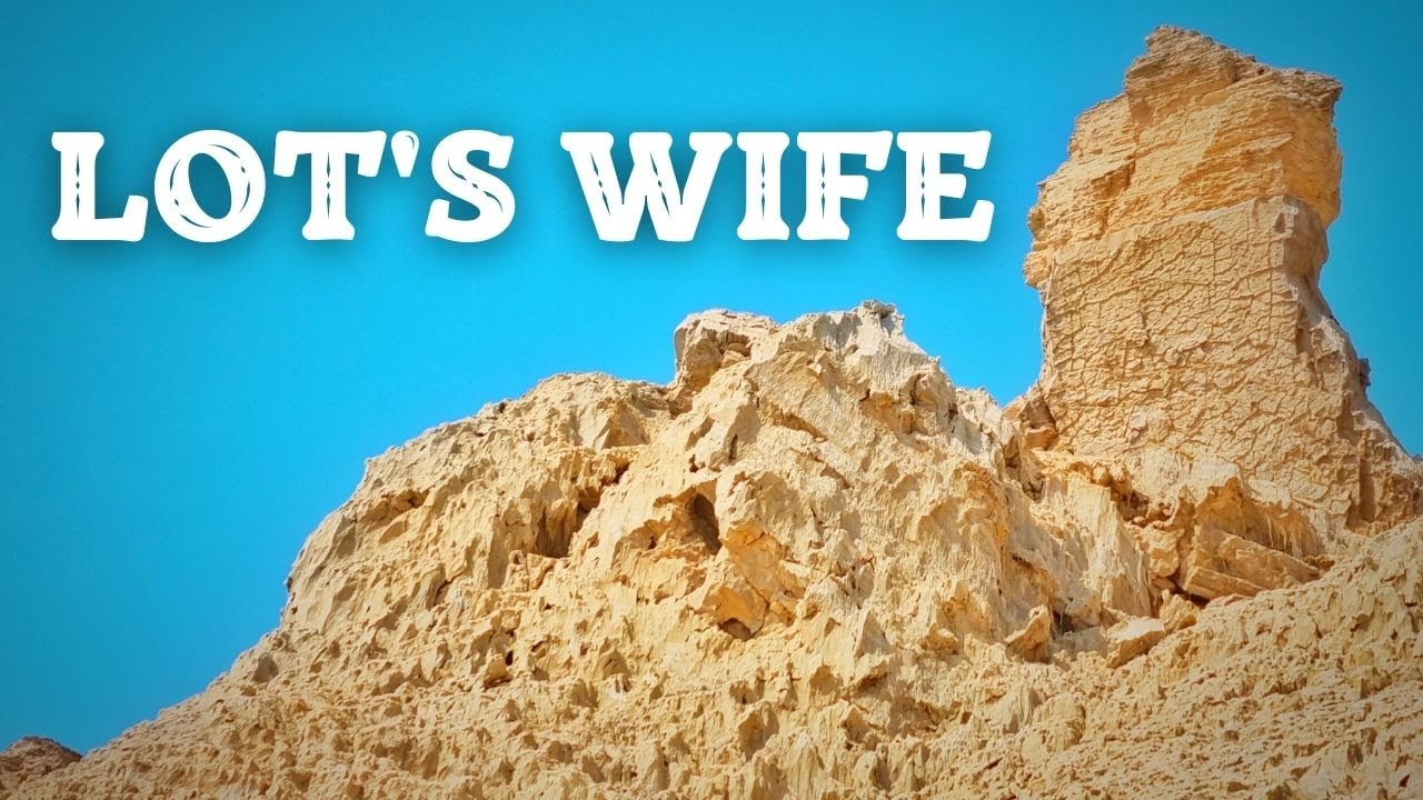
salt lake city=alchemy (salt)=dollar=$= LOT S WIFE (SODOMA AND GOMORRA)
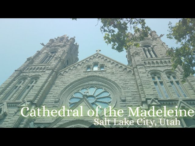
Cathedral of the Madeleine
From Wikipedia, the free encyclopedia
The Cathedral of the Madeleine is a Roman Catholic church in Salt Lake City, Utah, United States. It was completed in 1909 and currently serves as the cathedral, or mother church, of the Diocese of Salt Lake City. It is the only cathedral in the U.S. under the patronage of St. Mary Magdalene.
Description[edit]
The cathedral was built under the direction of Lawrence Scanlan, the first bishop of Salt Lake City, who dedicated it to St. Mary Magdalene.[2] It was designed by architects Carl M. Neuhausen and Bernard O. Mecklenburg. The exterior is predominantly a Neo-Romanesque design, while the inside displays more Neo-Gothic details. Construction began in 1900 and was completed in 1909. It was dedicated by James Cardinal Gibbons, Archbishop of Baltimore.
It is theorized that Bishop Scanlan chose Mary Magdalene as the patron saint of the Diocese of Salt Lake because her feast day is on July 22, two days before Pioneer Day, a celebration commemorating the arrival of the Mormon pioneers in Salt Lake Valley, so that Catholics would have something to celebrate alongside the region's dominant faith.[3]
The interior of the cathedral was created under the direction of Joseph S. Glass, the second bishop of Salt Lake. Bishop Glass enlisted John Theodore Comes, one of the preeminent architects in the country, to decorate the interior of the cathedral. His plans for the interior were largely based upon the Spanish Gothic style. The colorful murals and polychrome were added at this time, as were the ornate shrines. In 1916, Bishop Glass also changed the name of the cathedral to the French spelling after visiting her purported tomb.[2]
In the 1970s, the exterior of the building was restored, and between 1991 and 1993, the interior of the cathedral was renovated and restored under Bishop William K. Weigand. This included not only the removal of dust and dirt and restoration of the interior but also changes to the liturgical elements of the cathedral to bring them into conformity with certain widespread changes in liturgical practice that developed after the Second Vatican Council.
This included constructing a new altar, moving the cathedra, creating a separate chapel for the Blessed Sacrament, and adding an ample baptismal font. The Blessed Sacrament Chapel also contains the tomb of Bishop Scanlan.[4] Resting atop the tomb is a case containing a small relic of Saint Mary Magdalene. The cathedral in Salt Lake City and the Basilica of Saint-Maximin-la-Sainte-Baume in France are the only cathedrals in the world holding first-class relics of the saint and are named in her honor.[5] The major restoration of the interior of the cathedral was accomplished through the vision of Monsignor M. Francis Mannion.[6]
The cathedral is home to the only co-educational Catholic Choir School in the United States. The Madeleine Choir School, established in 1996, now serves over 400 students in Pre-Kindergarten through Grade Eight.[7] The Cathedral Choir has recorded several CDs and routinely tours both nationally and internationally. In addition to singing daily services at the Cathedral of the Madeleine, choristers have sung at St. Peter's Basilica (Vatican City), Notre Dame de Paris (France), and in churches across the United States of America, Spain, Italy, France, Belgium, and Germany, among other places.[8]
Composer Amédée Tremblay notably served as the church's organist from 1920 to 1925.[9]
-
-
Cathedral of the Madeleine, looking east
-
Interior of the cathedral
-
  |
|
|
|
|
Jordan River (Utah)
From Wikipedia, the free encyclopedia
The Jordan River, in the state of Utah, United States, is a river about 51 miles (82 km) long. Regulated by pumps at its headwaters at Utah Lake, it flows northward through the Salt Lake Valley and empties into the Great Salt Lake. Four of Utah's six largest cities border the river: Salt Lake City, West Valley City, West Jordan, and Sandy. More than a million people live in the Jordan Subbasin, part of the Jordan River watershed that lies within Salt Lake and Utah counties. During the Pleistocene, the area was part of Lake Bonneville.
Members of the Desert Archaic Culture were the earliest known inhabitants of the region; an archaeological site found along the river dates back 3,000 years. Mormon pioneers led by Brigham Young were the first European American settlers, arriving in July 1847 and establishing farms and settlements along the river and its tributaries. The growing population, needing water for drinking, irrigation, and industrial use in an arid climate, dug ditches and canals, built dams, and installed pumps to create a highly regulated river.
Although the Jordan was originally a cold-water fishery with 13 native species, including Bonneville cutthroat trout, it has become a warm-water fishery where the common carp is most abundant. It was heavily polluted for many years by raw sewage, agricultural runoff, and mining wastes. In the 1960s, sewage treatment removed many pollutants. In the 21st century, pollution is further limited by the Clean Water Act, and, in some cases, the Superfund program. Once the home of bighorn sheep and beaver, the contemporary river is frequented by raccoons, red foxes, and domestic pets. It is an important avian resource, as are the Great Salt Lake and Utah Lake, visited by more than 200 bird species.
Big Cottonwood, Little Cottonwood, Red Butte, Mill, Parley's, and City creeks, as well as smaller streams like Willow Creek at Draper, Utah, flow through the sub-basin. The Jordan River Parkway along the river includes natural areas, botanical gardens, golf courses, and a 40-mile (64 km) bicycle and pedestrian trail, completed in 2017.[6]
The Jordan River is Utah Lake's only outflow. It originates at the northern end of the lake between the cities of Lehi and Saratoga Springs. It then meanders north through the north end of Utah Valley for approximately 8 miles (13 km) until it passes through a gorge in the Traverse Mountains, known as the Jordan Narrows. The Utah National Guard base at Camp Williams lies on the western side of the river through much of the Jordan Narrows.[7][8] The Turner Dam, located 41.8 miles (67.3 km) from the river's mouth (or at river mile 41.8) and within the boundaries of the Jordan Narrows, is the first of two dams of the Jordan River. Turner Dam diverts the water to the right or easterly into the East Jordan Canal and to the left or westerly toward the Utah and Salt Lake Canal. Two pumping stations situated next to Turner Dam divert water to the west into the Provo Reservoir Canal, Utah Lake Distribution Canal, and Jacob-Welby Canal. The Provo Reservoir Canal runs north through Salt Lake County, Jacob-Welby runs south through Utah County. The Utah Lake Distribution Canal runs both north and south, eventually leading back into Utah Lake.[9] Outside the narrows, the river reaches the second dam, known as Joint Dam, which is 39.9 miles (64.2 km) from the river's mouth. Joint Dam diverts water to the east for the Jordan and Salt Lake City Canal and to the west for the South Jordan Canal.[10][11][12]

Map of the Salt Lake Valley
The river then flows through the middle of the Salt Lake Valley, initially moving through the city of Bluffdale and then forming the border between the cities of Riverton and Draper.[7] The river then enters the city of South Jordan where it merges with Midas Creek from the west. Upon leaving South Jordan, the river forms the border between the cities of West Jordan on the west and Sandy and Midvale on the east. From the west, Bingham Creek enters West Jordan. Dry Creek, an eastern tributary, combines with the main river in Sandy. The river then forms the border between the cities of Taylorsville and West Valley City on the west and Murray and South Salt Lake on the east. The river flows underneath Interstate 215 in Murray. Little and Big Cottonwood Creeks enter from the east in Murray, 21.7 miles (34.9 km) and 20.6 miles (33.2 km) from the mouth respectively. Mill Creek enters on the east in South Salt Lake, 17.3 miles (27.8 km) from the mouth. The river runs through the middle of Salt Lake City, where the river travels underneath Interstate 80 a mile west of downtown Salt Lake City and again underneath Interstate 215 in the northern portion of Salt Lake City. Interstate 15 parallels the river's eastern flank throughout Salt Lake County. At 16 miles (26 km) from the mouth, the river enters the Surplus Canal channel. The Jordan River physically diverts from the Surplus Canal through four gates and heads north with the Surplus Canal heading northwest. Parley's, Emigration, and Red Butte Creeks converge from the east through an underground pipe, 14.2 miles (22.9 km) from the mouth.[7] City Creek also enters via an underground pipe, 11.5 miles (18.5 km) from the river's mouth. The length of the river and the elevation of its mouth varies year to year depending on the fluctuations of the Great Salt Lake caused by weather conditions. The lake has an average elevation of 4,200 feet (1,300 m) which can deviate by 10 feet (3.0 m).[3] The Jordan River then continues for 9 to 12 miles (14 to 19 km) with Salt Lake County on the west and North Salt Lake and Davis County on the east until it empties into the Great Salt Lake.[7][8][11]
Discharge[edit]
The United States Geological Survey maintains a stream gauge in Salt Lake City that shows annual runoff from the period 1980–2003 is just over 150,000 acre-feet (190,000,000 m3) per year or 100 percent of the total 800,000 acre-feet (990,000,000 m3) of water entering the Jordan River from all sources. The Surplus Canal carries almost 60 percent of the water into the Great Salt Lake, with various irrigation canals responsible for the rest. The amount of water entering the Jordan River from Utah Lake is just over 400,000 acre-feet (490,000,000 m3) per year. Inflow from the 11 largest streams feeding the Jordan River, sewage treatment plants, and groundwater each account for approximately 15 percent of water entering the river.[13]
Watershed[edit]

Map of the entire Jordan River Basin
|
|
|
 Primer
Anterior
27 a 41 de 41
Siguiente Primer
Anterior
27 a 41 de 41
Siguiente
 Último
|
|
| |
|
|
©2024 - Gabitos - Todos los derechos reservados | |
|
|