|
|
General: ADAM SMITH, EL CAPITALISMO Y SU NEXO CON MARIA LA MAGDALENA
Elegir otro panel de mensajes |
|
|
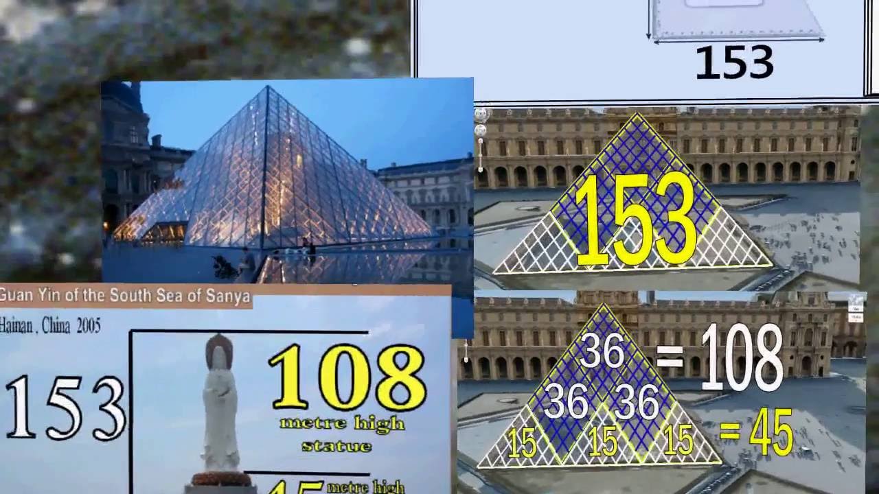
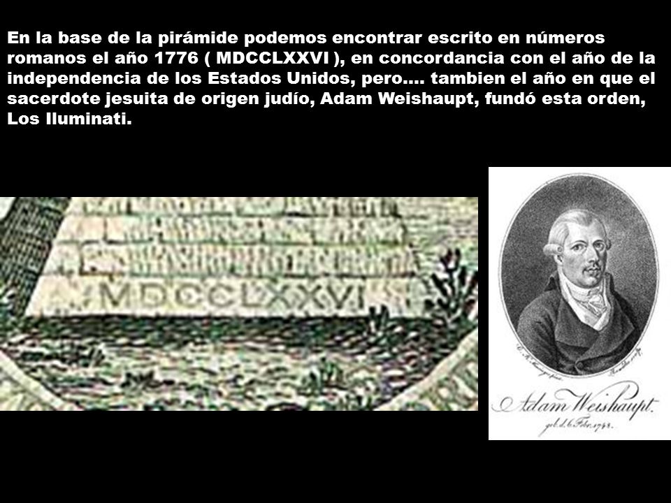
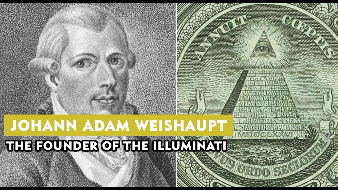
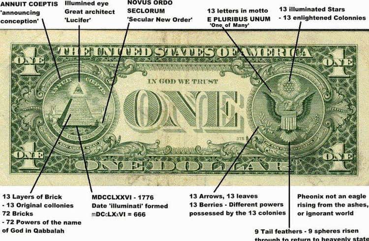
 Aqui tenemos a Pi - la circunferencia del toro y la vesica piscis 256/153 equivalente a la raiz cuadrada de 3 En el hipercubo las coordinadas binarias de Piscis son decimal 3 y binario 11 153 los pescados de Jesus en la biblia
|
|
|
|
|
 El sector agropecuario argentino se desarrolló muy bien, es cierto. Pero, ¿existió un modelo que lo beneficiaba a costa de posponer la industria? ( Twitter)
La idea de que el motor del desarrollo, para algunos, o que el modelo «desindustrializador», para otros, se basó en un programa «agroexportador» es un dogma. No importa la orientación del texto de estudio (que casi siempre va para el mismo lado), la idea de que el Estado argentino fomentó un esquema basado en el desarrolló del sector agropecuario es indiscutida. Al salir de la escuela secundaria o la universidad, el mito ya fue estudiado y repetido de memoria y rendido todos los exámenes aprobados por el cuerpo docente.
Agustín Etchebarne, economista liberal y director de la Fundación Libertad y Progreso, se propuso comenzar a derribar un mito, que ya se hizo carne en todos los argentinos. Los datos lo respaldan, pero abrir este debate en particular es sin dudas todo un desafío.
En un nuevo video de su fundación, que ya alcanzó las 25 mil visitas a las pocas horas de ser compartido, Etchebarne comenta con lujo de detalles como en realidad el modelo de la Constitución de Juan Bautista Alberdi se trató de un esquema de apertura general y no de privilegios o respaldos a un sector en particular. «El proyecto estaba basado en el respeto a la vida, la libertad y la propiedad privada. Con ese marco, nuestro país se convirtió en uno de los más avanzados, con una estructura productiva diversificada», señala el economista en la producción audiovisual.
Para Etchebarne, la repetición del mito del modelo agroexportador podría tener como intención desvalorizar al modelo liberal, para asociarlo con un sector en particular: «la oligarquía vacuna». De esta manera, la insistencia del relato ha contribuido a instalar en el imaginario colectivo que el modelo de apertura y libertad económica, supuestamente generador de grandes desigualdades, llevaría al desarrollo exclusivo del campo, dadas las características de Argentina.
Sin embargo, en contra de una de las creencias más arraigadas en el país, Etchebarne confirma que el modelo de la Constitución de 1853 no era otro que el «industrialista de la escuela de Adam Smith«. De esta manera, Argentina consiguió posicionarse como el país número uno del mundo en 1895 en ingreso per capita, permaneciendo medio siglo en el top ten del planeta. En uno de los segmentos más interesantes del video, el director de Libertad y Progreso, recuerda que a pesar del modelo de apertura económica, para 1914, el 71 % de todos los productos consumidos localmente eran industria argentina. Para 1922, esa industria local había ya superado la producción del sector agropecuario.
«En 1932, la industria argentina era más grande que la de México y Brasil sumadas. Para 1943, la industria ya exportaba el 20 % de su producción». Sin dudas que el dato mata el relato.
Lógicamente, luego se analiza el final del modelo de la mano del proteccionismo, que no hizo otra cosa que terminar perjudicando al sector que en teoría había venido a beneficiar. Aunque la idea del modelo agroexportador argentino esta arraigada en todos los sectores, la historia muestra otra cosa muy diferente. Es hora de abrir un debate indispensable para discutir el futuro del país.
Cuando comenzamos el PanAm Post para tratar de llevar la verdad sobre América Latina al resto del mundo, sabíamos que sería un gran desafío. Pero fuimos recompensados por la increíble cantidad de apoyo y comentarios de los lectores que nos hicieron crecer y mejorar.
¡Forma parte de la misión de difundir la verdad! Ayúdenos a combatir los intentos de silenciar las voces disidentes y contribuye hoy.
|
|
|
|
|
4 jun. 2019 - Subido por Spanish Libertarian
junio 4, 2019 7:34 am by: Agustín Etchebarne A+ / A-. Agustín Etchebarne en Spanish Libertarian. ... Emilio ...
|
|
|
|
|
13 jun. 2007
Nexo entre la Escuela de Salamanca y la Escuela Austríaca de Economía. Análisis del método de estudio ...
7 mar. 2017 - Subido por Escuela Austriaca
La Escuela de Economía de Salamanca - Jesús Huerta de Soto. EscuelaAustriaca. Loading... Unsubscribe ...
18 sept. 2017 - Subido por Academia Play
Suscríbete al Canal de VisualPolitik: http://bit.ly/1Wl5TDd Haz una donación en Patreon: https://www.patreon.com ...
2 feb. 2018 - Subido por Fundación Rafael del Pino
... en el pensamiento económico de la Escuela Española de Economía ... Angel Fernandez gran trabajo sobre La ...
29 oct. 2012
Surgimiento de las ideas de la Escuela Austriaca de Economía. Influencias en ... Escuela de Salamanca, de ...
20 nov. 2018 - Subido por Intereconomiatube
Suscríbete a nuestro nuevo canal ↙ ✓ https://www.youtube.com/channel/UC2T6NU6-JLWzAzaGdqvNyzA ...
12 sept. 2018 - Subido por NEWMEDIA UFM
Inscríbete al curso en línea: salamanca.ufm.edu La Escuela de ... Escuela deSalamanca sobre derechos ...
|
|
|
|
|

Jordan River (Utah)
From Wikipedia, the free encyclopedia
The Jordan River, in the state of Utah, United States, is a river about 51 miles (82 km) long. Regulated by pumps at its headwaters at Utah Lake, it flows northward through the Salt Lake Valley and empties into the Great Salt Lake. Four of Utah's six largest cities border the river: Salt Lake City, West Valley City, West Jordan, and Sandy. More than a million people live in the Jordan Subbasin, part of the Jordan River watershed that lies within Salt Lake and Utah counties. During the Pleistocene, the area was part of Lake Bonneville.
Members of the Desert Archaic Culture were the earliest known inhabitants of the region; an archaeological site found along the river dates back 3,000 years. Mormon pioneers led by Brigham Young were the first European American settlers, arriving in July 1847 and establishing farms and settlements along the river and its tributaries. The growing population, needing water for drinking, irrigation, and industrial use in an arid climate, dug ditches and canals, built dams, and installed pumps to create a highly regulated river.
Although the Jordan was originally a cold-water fishery with 13 native species, including Bonneville cutthroat trout, it has become a warm-water fishery where the common carp is most abundant. It was heavily polluted for many years by raw sewage, agricultural runoff, and mining wastes. In the 1960s, sewage treatment removed many pollutants. In the 21st century, pollution is further limited by the Clean Water Act, and, in some cases, the Superfund program. Once the home of bighorn sheep and beaver, the contemporary river is frequented by raccoons, red foxes, and domestic pets. It is an important avian resource, as are the Great Salt Lake and Utah Lake, visited by more than 200 bird species.
Big Cottonwood, Little Cottonwood, Red Butte, Mill, Parley's, and City creeks, as well as smaller streams like Willow Creek at Draper, Utah, flow through the sub-basin. The Jordan River Parkway along the river includes natural areas, botanical gardens, golf courses, and a 40-mile (64 km) bicycle and pedestrian trail, completed in 2017.[6]
The Jordan River is Utah Lake's only outflow. It originates at the northern end of the lake between the cities of Lehi and Saratoga Springs. It then meanders north through the north end of Utah Valley for approximately 8 miles (13 km) until it passes through a gorge in the Traverse Mountains, known as the Jordan Narrows. The Utah National Guard base at Camp Williams lies on the western side of the river through much of the Jordan Narrows.[7][8] The Turner Dam, located 41.8 miles (67.3 km) from the river's mouth (or at river mile 41.8) and within the boundaries of the Jordan Narrows, is the first of two dams of the Jordan River. Turner Dam diverts the water to the right or easterly into the East Jordan Canal and to the left or westerly toward the Utah and Salt Lake Canal. Two pumping stations situated next to Turner Dam divert water to the west into the Provo Reservoir Canal, Utah Lake Distribution Canal, and Jacob-Welby Canal. The Provo Reservoir Canal runs north through Salt Lake County, Jacob-Welby runs south through Utah County. The Utah Lake Distribution Canal runs both north and south, eventually leading back into Utah Lake.[9] Outside the narrows, the river reaches the second dam, known as Joint Dam, which is 39.9 miles (64.2 km) from the river's mouth. Joint Dam diverts water to the east for the Jordan and Salt Lake City Canal and to the west for the South Jordan Canal.[10][11][12]

Map of the Salt Lake Valley
The river then flows through the middle of the Salt Lake Valley, initially moving through the city of Bluffdale and then forming the border between the cities of Riverton and Draper.[7] The river then enters the city of South Jordan where it merges with Midas Creek from the west. Upon leaving South Jordan, the river forms the border between the cities of West Jordan on the west and Sandy and Midvale on the east. From the west, Bingham Creek enters West Jordan. Dry Creek, an eastern tributary, combines with the main river in Sandy. The river then forms the border between the cities of Taylorsville and West Valley City on the west and Murray and South Salt Lake on the east. The river flows underneath Interstate 215 in Murray. Little and Big Cottonwood Creeks enter from the east in Murray, 21.7 miles (34.9 km) and 20.6 miles (33.2 km) from the mouth respectively. Mill Creek enters on the east in South Salt Lake, 17.3 miles (27.8 km) from the mouth. The river runs through the middle of Salt Lake City, where the river travels underneath Interstate 80 a mile west of downtown Salt Lake City and again underneath Interstate 215 in the northern portion of Salt Lake City. Interstate 15 parallels the river's eastern flank throughout Salt Lake County. At 16 miles (26 km) from the mouth, the river enters the Surplus Canal channel. The Jordan River physically diverts from the Surplus Canal through four gates and heads north with the Surplus Canal heading northwest. Parley's, Emigration, and Red Butte Creeks converge from the east through an underground pipe, 14.2 miles (22.9 km) from the mouth.[7] City Creek also enters via an underground pipe, 11.5 miles (18.5 km) from the river's mouth. The length of the river and the elevation of its mouth varies year to year depending on the fluctuations of the Great Salt Lake caused by weather conditions. The lake has an average elevation of 4,200 feet (1,300 m) which can deviate by 10 feet (3.0 m).[3] The Jordan River then continues for 9 to 12 miles (14 to 19 km) with Salt Lake County on the west and North Salt Lake and Davis County on the east until it empties into the Great Salt Lake.[7][8][11]
Discharge[edit]
The United States Geological Survey maintains a stream gauge in Salt Lake City that shows annual runoff from the period 1980–2003 is just over 150,000 acre-feet (190,000,000 m3) per year or 100 percent of the total 800,000 acre-feet (990,000,000 m3) of water entering the Jordan River from all sources. The Surplus Canal carries almost 60 percent of the water into the Great Salt Lake, with various irrigation canals responsible for the rest. The amount of water entering the Jordan River from Utah Lake is just over 400,000 acre-feet (490,000,000 m3) per year. Inflow from the 11 largest streams feeding the Jordan River, sewage treatment plants, and groundwater each account for approximately 15 percent of water entering the river.[13]
Watershed[edit]

Map of the entire Jordan River Basin
|
|
|
|
|
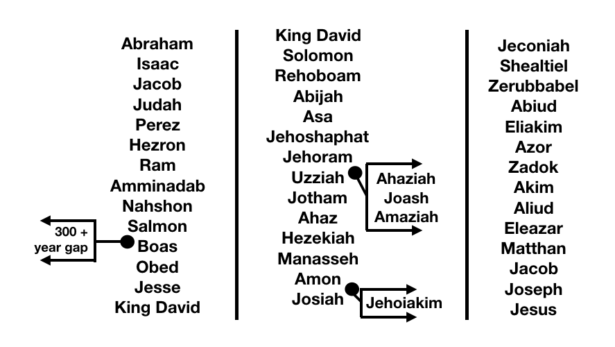
KING DAVID / JOSEPH / SOLOMON
|
|
|
 Primer
Anterior
35 a 49 de 49
Siguiente Primer
Anterior
35 a 49 de 49
Siguiente
 Último
|
|
| |
|
|
©2024 - Gabitos - Todos los derechos reservados | |
|
|