|
|
GIZE, STONEHENGE, CHICHEN ITZA, ETC,ETC: RAPA NUI-EASTER ISLAND... DECIPHERED
Scegli un’altra bacheca |
|
Rispondi |
Messaggio 1 di 22 di questo argomento |
|
EASTER ISLAND… DECIPHERED
BREAKING NEW RELEASE MARCH 2012: – Easter Island, known originally as Rapanui is a very small remote island positioned very far from any continent and is literally all on its own in the middle of the Pacific Ocean. It is "a lost civilisation" and their secrets also lost. The Rapanui people after many researcher's interviews over a hundred years ago and in the more recent years have confirmed they have lost the original meaning of their own culture and hence why it remains a mystery to this day. The island has well over 800 giant megalithic statues called Moai that have baffled the world for centuries.
Many a theory of the meaning of the statues have been published but strangely not one of them ever really presented a complete well-reasoned story showing all the evidence suggesting why they built the statues and what the people believed about them.
Easter Island’s general history is well documented on line. To learn more about it go to Wikipedia before reading further …(ref)
Wayne recently made a few decisive breakthroughs that add new pieces to the puzzle. Here is the full presentation of what he believes makes the most sense.
NEW READERS PLEASE NOTE
It is important for those first reading this story to know that Wayne will be using the term ‘sol star’. It refers to a specific star area in Taurus near the Pleiades and Orion, a commonality he has found in virtually all ancient civilisations. If these new breakthroughs sound confusing to you, listed here are the other ancient sites for more on Wayne’s star map discoveries for you to browse through: …(ref)
The so called star blueprint code that Wayne has found important in virtually all ancient civilisations is seen in the animation below. This is what will be compared with Easter Island.

| |
|
The sources of clues here are derived from works by original explorer Thor Heyerdhal …(ref) Some forgotten excavation discoveries not made public in the unearthing of some Moai from the 1915 Routledge excavation project …(ref)
Also the Google Earth observation source when viewed from the sky (image credit)… also oral tradition of what was passed down through the Rapanui descendants but most of all, new deductions comparing to Wayne’s globally common first civilisations star map theory… and testing if it fits his measurable blueprint star map hypothesis.
10 EASTER ISLAND FACTS AND NEW BREAKTHROUGH CLUES
Here is a list of the most inspiring Easter Island facts and new clues Wayne has pieced together:
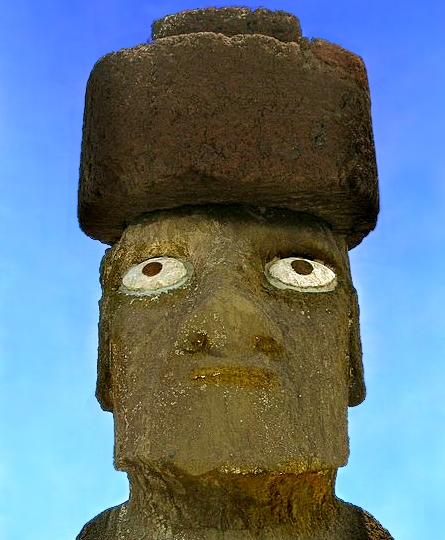
1) There are two main varieties of statues: widespread single Moai numbering close to 800 and of average masses between 30 to 40 tons are found all around the edge of the island mysteriously and haphazardly buried with generally only head and shoulders appearing. They are the type seen in the image at the top of this page.
2) They were megalith block builders of pristine perfection and style of block building just like the ancient Inca of Peru. Some stunning examples seen here …(ref)
3) Some Moai are seen as special… the bigger variety standing on a special platform called Ahu. Some scholars say it represents a celestial canoe. Fantastic clue here.
4) All Moai statues, both on the Ahu platforms and those buried all over the island have their gaze set above the horizon. But the statues all around the coastline of the island have an extra feature… Their heads tilt backwards forcing their intense gaze much higher above the horizon towards the sky as per the image at the top of this page. The free standing Moai variety on Ahu platforms are the most sacred and some are crowned with head stones called Pukao as in the image below. The eyes looking at the sky above the horizon forces one to challenge a recent claim that they are looking for their ancestors homeland. The iris here, even if it is a modern addition is not an issue to consider when evaluating the general head position and direction of stare. They are all still looking just above the horizon, even if the iris was positioned normally. …(ref)
The Egyptians wore round objects on their heads representing celestial bodies. Is it possible the Moai are doing the same but the round objects are horizontal and not vertical? When seen from above, they appear identical to what is known as the circumpunct, a dot in the middle of a circle which represents a celestial body.
| |
|
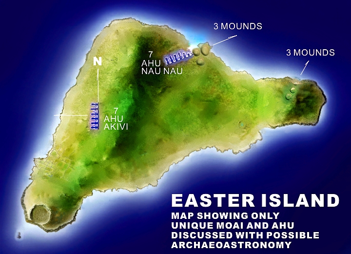
5) There are two groups of three mounds that were regarded as sacred, one with three in a row towards the western rocky cliff area of Maunga Parehe and one with three in a tight triangular cluster at the earliest known historical site called Anakena beach. This is the place to look for a blue print code. The place of the foundations of the first Easter Island civilisation. The bay area at Anakena beach in the Northern central area was also once the most beautiful area with masses of palm trees. Most books on Easter Island don’t mention any sacred mounds at all.
6) Of the sacred statues, only one Ahu platform called Ahu Nau Nau that has 7 Moai is poised next to the most sacred cluster of three mounds and it is located in the place of first settlement at Anakena, the ‘place of the beginning’. Found here is the island’s only beautiful white sand bay.
7) Also another strange clue. All the Ahu Moai watch the sky but they do so facing inland, all but one Ahu, the Ahu Akivi also with 7 Moai. These watch the western ocean horizon and are also crowned with heavy head stones called Pukao.
8) There are carvings that show clusters of an entity that is half bird, half man, exactly like the star obsessed cult of the Egyptians. Note the word cluster. This was another clue what Wayne was looking for. The historical Pleiades symbol’s unique aspect is the tight cluster nature of the Pleiades which he believes it has a connection to.
9) Completely surprising was the unrecognised symbols match at first glance to other ancient civilisations not published at all, ancient symbols found on the other side of the planet.
10) There was also clear evidence of star deity obsession with some stone carvings and their earliest writing in the script called Ronga Ronga.
| |
|
Key details… ‘Ahu’ are the platforms the two separate areas here show (blue glow) that have seven ‘Moai’ statues standing on them.
UNEARTHING CATACLYSMIC BURRIED MOAI SHOW FULL BODIES, HANDS AND SYMBOLS
The greatest ‘hidden’ records of the Rapanui people seemed to be missing in the most popular books on Easter Island. The details explored here now will speak their long lost secrets. The amazing excavation of an unusual protocol expedition in 1914 called the Routledge excavation project was revisited by recent archaeologists and they re-excavated the intentionally buried evidence for a second time.
How does Wayne know for sure it was re-buried. Its simple. The image of the two Moai in the images that follow have serial names and were shown in a recent modern technology colour image completely buried. They are the same Moai that were shown uncovered in old black and white film from 1915 in the link that follows.
How strange is that just for starters? The first expedition unearthed them and documented the breaking discovery pictographic evidence, didn’t make it public in a big way at all, then for unknown reasons, buried them again! This is insane! What could have been so shocking for them to have been completely covered up again?
The Moai were recently unearthed for a second time and they have it documented here …(ref)
The image below shows how much of the Moai are buried by photoshopping a person between the statue to show size. What logic is there in burying most of the anatomies of the Moai that the craftsmen so painstakingly carved just to place them below soil level. The Moai is covered in beautiful carved symbols and it has long thin arms and hands too.
EASTER ISLAND MATCHES PLACES ON THE OTHER SIDE OF THE PLANET
The thin arms art style reaching forward with fingers pointing down at 45 degrees is exactly like the recently unearthed megaliths at Gobekli Tepe in Turkey. This alone speaks volumes and if this isn’t convincing enough, the two large symbols on the back of the Moai are of the same theme and style too.
By chance having two individual civilisations on opposite sides of the planet, one located in the middle of an ocean, having the same obsession with massive stone carvings and showing the same symbols, story, style and entity appearance is absolutely mind blowing!
Look at the statue of a man unearthed at the Gobekli Tepe site… it has the similar square topped long head and big long nose and long jawline. This is a breakthrough here and it’s a definite link between knowledge and theology.
Question is how did they carry the same story? This will be addressed in the conclusion.
In the image below, one Moai is buried up to its eyes… a substantial cataclysm clue! Here is another obvious clue, many of the Moai have half of their bodies buried but have obscure angles.
Why on Earth would they set an obscure angle like this in a statue ‘burial’ ritual? They simply can’t tilt by themselves with half their body buried. Something cataclysmic occurred here on Easter Island and it was no earthquake either.
THE 'M' SYMBOL ON MOAI… ONE SHOWN BELOW THE ‘O’ SYMBOL
In the image below the Gobekli Tepe megalith and statue are superimposed above the Moai statue listed as RR-001-156 for comparison. The ‘M’ symbol is shown beneath the ‘O’ symbol whereas the ‘H’ symbol seen to be Orion at Gobeki – who watched the western horizon – has it placed above the ‘O’ symbol. First thing that came to mind is that the ‘M’ symbol might be Orion here and it would be true if they are celebrating the same star Wayne was looking for fitting the ‘O’ symbol… the ultimate Sun star of the ancients found all around the globe.
|
|
|
|
|
|
|
Rispondi |
Messaggio 8 di 22 di questo argomento |
|
| |
|
Wayne saw the four curved lines (purple) first and looked a little closer. His first thoughts are they have little symbols that he knew well… they had what looked like comets… (turquoise stars) and three different positions too as if it was a documenting of a large comet in its correct tail facing upward positions over a correctly curved west or east horizon. It depicted an altering very familiar tail angle (its coma) which occurs over the days it seems to be recorded.
This could be the first example of how the terra firma curved Earth horizon was documented, inspiring the symbol on the Moai.
There is another depiction of the comet (green) amongst the birdmen deities… a cluster of birdmen that Wayne believes could be representation of the Pleiades (lowest portion cluster)… Orion (upper portion of three) and a group of three, the solar Trinity obsession he was looking for (with three yellow dots). This is all general speculation for now of course. One needs a lot more evidence first before making such loosely woven claims.
|
|
|
|
|
|
Rispondi |
Messaggio 9 di 22 di questo argomento |
|
| |
|
Lets have another look at the earlier birdman stone carving (repeated below). It is found in the Eastern territory near this depiction of a Rapanui face.
There were two clues on the stone carving that use a symbol of a ‘3’ … it is also possible it could be a bird as if in flight. But it wasn’t until much later this symbol would be proven as Orion when Wayne recognised its importance as a bird deity on another Moai.
|
|
|
|
|
|
|
Rispondi |
Messaggio 10 di 22 di questo argomento |
|
| |
|
Since a comet is being measured across a few bands as shown in purple on the moai like in the previous rock carving of the birdmen… it is likely this multiple line of bands is the horizon…. The most sacred apparently to the Rapanui people… the Western Horizon.
Here is another Moai with birdmen and Orion poised in its appropriate place. We will test this all on a star program and see what we find below the horizon where the strange McDonalds’ style ‘M’ is depicted.
|
|
|
|
|
|
Rispondi |
Messaggio 11 di 22 di questo argomento |
|
| |
|
Wayne discovered only recently that not many researchers speak of sacred mounds but no excavations have proven if they were manmade or hills that were sculptured. The first group we look at here are the three mounds in a row as seen on the map on the eastern part of the island.
|
|
|
|
|
|
|
Rispondi |
Messaggio 12 di 22 di questo argomento |
|
| |
|
There are people standing on the head of this lost monument! There is far more than just a visual connection which some will say is quite extraordinary on its own. Firstly if the statue is as old as it claims to be and near one of the oldest Maya cities of southern Guatemala then it would be fair to compare to what was else was special with the city of Tikal because it too holds a very alien theme... one completly officially denied by scholars so far because alien claims are officially scorned until further notice.
|
|
|
|
|
|
|
Rispondi |
Messaggio 13 di 22 di questo argomento |
|
|
|
|
Rispondi |
Messaggio 14 di 22 di questo argomento |
|
Desde mediados de octubre a mediados de febrero Orión nos acompaña en las Noches de la Tierra.

El planeta que llamamos "La Tierra" se desplaza en el Espacio sin superficie, es decir, sin apoyarse en ningún plano. Nosotros, como navegantes de la Nave Tierra, quizá en otro episodio de nuestra Vida fuimos navegantes en un barco sobre la superficie del agua de la Tierra. Y quizá entonces nos apostamos alguna vez en la vela mayor y avistamos tierra y gritamos "Tierra a la vista!", o alguna vez fuéramos náufragos en un desierto de arena, descubriéramos un oasis y gritáramos "¡Agua a la vista!".
Durante estos meses de travesía (de octubre a abril) en el Planeta hemos comenzado a tener visión nocturna de la constelación de Orión, a modo de un espectacular archipiélago de islas relucientes que vemos a lo lejos, aunque al mismo tiempo impreso en nuestras pupilas y neuronas, también estrellas ellas. Al menos las pupilas son las Niñas de los ojos (no tanto nuestras niñas, aunque digamos "nuestros" ojos).
Por eso , estando en la Nave Tierra y mirando al océano cósmico podemos gritar "¡Orión a la vista!".
Lo que para nosotros es delante y detrás e izquierda y derecha (nuestras direcciones egográficas) en un barco, un navío o un velero es proa y popa y babor y estribor. ¿Y para la Nave Tierra? Para una nave esférica como un planeta, el lado de proa/delante es el lado por el que avanza en su traslación, el lado del amanecer, y el lado de popa/detrás es el anochecer. El lado de babor es el lado iluminado por la Isla/Faro, el Sol, y el de estribor es el lado nocturno, la Noche durante la que podemos ver las demás estrellas, también islas/faros. (Pondré las imágenes correspondientes).
|
 |
Por eso, desde la Nave Tierra, durante estos meses podemos ver a Orión por Estribor en toda su esplendidez asomando por el horizonte oriental. "Asomando" es una forma alegórica de decir que, debido al giro del Planeta, nosotros cogemos línea de visión de Orión, es decir, que los rayos de luz de sus estrellas llegan de nuevo a nuestras pupilas, pues Orión (como el Sol) no se mueve (relativamente). Se mueve y desplaza el Planeta Madre, de modo que nos movemos los hijos, pues hay un momento en que se ha de superar la idea de la Edad Media en la que se basa la Edad Moderna. En la siguiente animación el punto blanco es uno de nuestros "yoes" en el sur de Japón, en la costa del Pacífico en la noche del 18 de diciembre, cuando en la medianoche la Nave Agua hace línea entre el Sol y la estrella Betelgeuse.
La noche del 18 de diciembre
Como ejemplo, esta imagen de los Moais de la Isla de Rapa Nui contemplando a Orión. Durante estas noches, a ya altas horas de la madrugada, podemos ver a Orión en esta misma "postura", como zambulléndose de cabeza tras el horizonte. La estrella Bellatrix es la primera que se oculta tras y bajo el horizonte oeste.
 
¿Imaginas el movimiento completo de Orión durante la noche?
El Movimiento de Traslación de la Nave Tierra hace que a cada noche a una misma hora -como las 12 de la noche- tengamos una visión de Orión igual que la que tenemos durante solamente 1 noche durante unas 14 horas. Es la misma película pero más lenta. Es el reflejo de la relación que hay entre el lentísimo movimiento de traslación de la Tierra comparado con su movimiento de rotación.
Mediasnoches del 15 de octubre al 15 de marzo
Vemos el punto de la órbita que en nuestra mente cronológica corresponde al 18 de diciembre, día reproducido en la primera animación de rotación de la Tierra y nuestra visión de Orión durante la noche del 18 de diciembre. Vemos que los movimientos son los mismos en dos escalas diferentes.
Observa cómo el movimiento de Traslación de la Tierra (un PLANETA) durante unos 4 meses, con una persona en la medianoche (el punto blanco fijo en la zona media de la Noche del Planeta), es el mismo que el movimiento de esa misma persona (el propio punto blanco) girando en la Tierra durante 12 horas cada noche debido a la Rotación de la Tierra. Y por tanto el reflejo de ambos movimientos (Orión "moviéndose") también es el mismo.
|
Noche del 18 de diciembre
|
Mediasnoches del 15 de octubre al 15 de marzo
|
¿Puede ser más simple y fácil de comprender la sencillez de la sincronía de los movimientos reales y aparentes en el Espacio del Universo? Son movimientos escalados, reproduciéndose a escalas proporcionales tanto de tamaño como de velocidad. Lo más fascinante es que nosotros como conciencia no estamos realmente en un punto fijo (otra cosa es nuestro cuerpo físico o nuestro yo no acostumbrado a tales "vuelos"). De hecho, podemos ver tales movimientos desde muchos puntos viendo perspectivas diferentes de lo mismo y que completan la visión.
Los movimientos APARENTES de las estrellas en el fondo oscuro son tan simples y ordenados porque así son los dos movimientos REALES de la Madre Tierra: giro y traslación, que son CIRCULARES y SIMULTÁNEOS. Son movimientos circulares que forman ciclos anidados y espirales armoniosos. Otra cosa es no haber mirado nunca al firmamento, tener la mente acelerada por costumbre que anestesia a la inteligencia y sensibilidad de la deliciosa ciencia de la paciencia y por ello concluir erróneamente que en el Cielo espacial -el mismo en el que está nuestro organismo y ojos y desde los que miramos estrellas o nubes o árboles, o nuestras propias manos- sólo hay caos, desorden y sinsentido. Todo lo contrario a una realidad de la sólo vemos la superficie y cuya profundidad desconocemos, aunque estamos invitados a descubrirla gratuitamente como una estrella más.
Para algo estamos en el Universo... y no sólo para abandonarlo sin haber siquiera rozado la Maravilla.
|
 |

De Cintura a Cinturón. Una romántica relación.
La anterior imagen podemos verla en una imagen de una vista más amplia con la Tierra en un 18 de diciembre. La proyección del extremo norte del Eje de Rotación apunta a la Estrella Polar. La proyección del plano del ecuador de la Tierra (línea roja proyectada como línea blanca discontinua, termina en el cinturón de Orión. Esto significa que las personas que viven en el ecuador del Planeta Tierra están justo entre el Corazón de la Tierra y el Cinturón de Orión en la medianoche del 18 de diciembre.
O sea, con sus coronillas justo "debajo" del cinturón de Orión, o el Cinturón de Orión justo encima de sus coronillas, de forma que para ver a Orión en la medianoche del 18 de diciembre estando en el ecuador, hay que elevar la vista 90 grados, pues Orión queda en el cénit correspondiente al cuerpo. También, en ese momento especial y espacial, estamos dirigiendo la mirada hacia el Ecuador celeste, la proyección del Ecuador de la Madre Tierra, su reflejo en el firmamento. En este sentido, Gea está ORIENtada hacia ORIÓN.
  
El plano de la órbita de la Tierra es la línea blanca en la que está el Sol. Al otro lado de esa línea, hay "otra Tierra" en el 18 de junio. Cada 18 de junio no podemos ver a Orión, porque la luz del Sol vela nuestra visión. En esta escena se ve clara (u oscuramente) que sólo podemos ver a Orión cuando la Nave Tierra se ha trasladado una sección circular (es decir, que nosotros hemos pasado una parte de año o n meses durante un trayecto curvo, aunque nos parezcan lineales).
También, al otro lado del Sol queda el Centro de la Galaxia.

La Nave Azul en el punto de su órbita durante nuestro 18 de diciembre.
Alineación Centro Galáctico, Sol, Tierra y Orión.
La visión espacial y posicional de los puntos que hay en el Espacio Universal, Cielo espacial, es una cuestión más que de geo/metría de cosmo/metría (aunque no usemos el "metro" para ello) porque la geometría (metro en la tierra) corresponde al ámbito de Gea, la Tierra. Es una forma espontánea de liberar la conciencia que se expande por sí misma a su dimensión espacial, el Cielo espacial, una de las dos naturalezas del misterioso -para la razón y corazón "terrenal"- Hilo que teje el Tejido EspacioTemporal del Universo.
De momento, tal razón/corazón "terreno" puede servirse de ORIÓN como ORIONtación celeste, pues está apareciendo por el Estribor de la Nave Agua y Tierra. También, entre las coordenadas geográficas, mirando hacia el Norte y a la Estrella Polar, el ORIENTE sería el estribor. Así que durante estas noches, a la Sombra de la Madre Tierra ORIENtada hacia ORIÓN, estamos viendo a ORION por el ORIENte cósmico.

He visto cosas que vosotros no creeríais: atacar naves en llamas más allá de Orión...
(Monólogo del replicante Roy, película "Blade Runner")
|
|
|
|
Rispondi |
Messaggio 15 di 22 di questo argomento |
|
MONUMENTOS ANTIGUOS
Desde la Isla de Pascua hasta Giza, y acabando de nuevo en la Isla de Pascua, hay 40 mil Km…
Y esta sorprendente LÍNEA pasa, nada más y nada menos que por…
PERU

ÁFRICA


En Egipto, OBVIAMENTE, también pasa por Giza…ERA EL CENTRO!


También por la supuesta cuna de nuestra civilizacion…los sumerios…


Y todos estoslugares están en la MISMA LÍNEA…Linea que seguramente en otra época fue el ECUADOR!!
")
IMPRESIONANTE!!!
Aunque todavía hay mucho más..Si tomamos esa línea como el ecuador y calculamos su polo norte, tenemos que:


Y si todavía hay alguien que no está soprendido con todo esto, que se prepare!
Utilizando la base de la gran pirámide y restando del circulo exterior al cuadrado, el círculo interior del cudrado…
")
La cifra se la llevaron a un físico y casi se cae de espaldas…no os perdais la cara que pone!!
")
Físico escéptico tratando de poner cara de poker después del mazazo de descubrir que hemos INVOLUCIONADO!!

CONOCÍAN TAMBIÉN LA VELOCIDAD DE LA LUZ!!!!!!!
Un metro es la distancia que recorre la luz en el vacío durante un intervalo de 1/299 792 458 de segundo
El primer número es el de la velocidad de la luz…y el segundo el obtenido de la pirámide…
Que os jugais a que todavía algún taliban dice que es casualidad????

http://virgiliotovar.blogspot.com.ar/2012/10/esfinge-2053-dias-y-contando.html |
|
|
|
Rispondi |
Messaggio 16 di 22 di questo argomento |
|
PART 6 - EASTER ISLAND
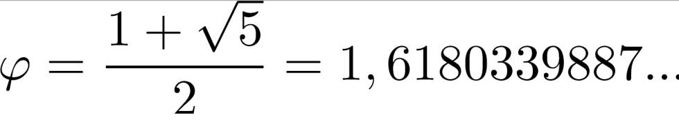
Easter Island is triangular and the three volcanic peaks on Easter form an isosceles triangle with an apex angle of 108° and base angles of 36°. The ratio between the length of the base and the lengths of the sides is φ (6.8 miles x 1.618 = 11 miles).
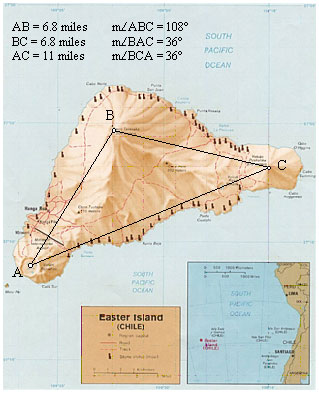
Image courtesy of the University of Texas
The southern coastline is roughly parallel to the great circle as it crosses over the island. The southwestern corner of Easter is 10,060 miles from Giza. The length of the great circle segments from the axis point to Easter and to Giza is 6,218 miles.
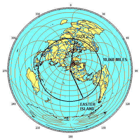
The ratio between the baselength of 10,060 miles and the side lengths of 6,218 miles is φ (6,218 x 1.618 = 10,060). The azimuth from the axis point to Giza is 9° and the azimuth from the axis point to Easter is 154°. The angle of the terrestrial triangle at the axis point is 145°. The terrestrial angles at Easter and Giza are 90°. These terrestrial angles convert to flat surface angles of 108° at the axis point and 36° at Easter and Giza. This is the same triangle that is formed by the three volcanic peaks on Easter and the same triangle that is found in a pentagram.

The φ ratio between the distance from Easter to Giza and the distances from the axis point to Easter and Giza is also shown by these measures in kilometers. One quarter of the circumference of the earth is 10,000 kilometers. The distance from Easter to Giza is 16,180 kilometers, expressing the φ ratio of 1.618 : 1.
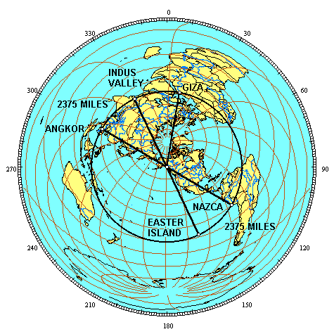
Easter is 2375 miles from Nazca. This is 9.54% of the circumference of the earth, or 34.34°. The axis point is 6218 miles from Easter and from Nazca. The ratio between one side of the terrestrial triangle and the baselength of the triangle is 2.618 to one (2375 miles x 2.618 = 6218 miles). The terrestrial triangle formed by Angkor Vihear, Easter’s antipodal point in the Indus Valley and the axis point has these same dimensions with the same φ² ratio between the side length and the base length. The terrestrial triangle formed by Easter’s antipodal point in the Indus Valley, Giza and the axis point has these same dimensions and the same φ² ratio.
|
|
|
|
Rispondi |
Messaggio 17 di 22 di questo argomento |
|
PART 7 - LINES THROUGH THE EARTH
The alignment of ancient sites may be viewed as a circle because all of the sites are on a straight line around the center of the earth. The two points where the circle crossse the equator are on the horizontal axis, and the two points where the circle reaches the highest latitudes are on the vertical axis. The center of the circle is the center of the earth. The distance from the center of the earth to any point on the circle is the radius of the earth (24,892 ÷ π ÷ 2 = 3962 miles).

The great circle distance from Easter Island to Nazca is 2375 miles, or 9.54% of the great circle (2375/24,892 = 09.54) or 34.344° (.0954 x 360 = 34.344°). This also gives 34.344° for the angle between the two sites at the center of the earth. One half of this angle is 17.172°.The straight line distance between the two sites is equal to the sine of one half of their angle at the center of the earth times the diameter of the earth. The sine of 17.172° is .29524. The diameter of the earth (7924 miles) times .29524 gives 2339.5 miles for the straight line (through the earth) distance from Easter to Nazca. The height of a triangle with sides of 3962 miles and a baselength of 2339.5 miles is 3785 miles. The baselength of the triangle times φ is equal to the height of the triangle (2339.5 x 1.618 = 3785). The center of the earth, Angkor and Easter’s antipodal point in the Indus Valley forms this same φ triangle, as does the triangle formed by the center of the earth, the Indus Valley and Giza.
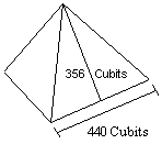
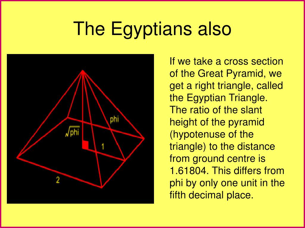
The length of the base of each face of the Great Pyramid is 440 cubits. The slant height of each face is 356 cubits. One half of the length of the base times φ equals the slant height of the Great Pyramid:
440 cubits ÷ 2 = 220 cubits
220 cubits x 1.618 = 356 cubits
The ratio of the base to the slant height of the Great Pyramid is exactly two times the ratio of the base to the height of the throught the earth triangles shown above.
Just south of Giza, the step pyramid at Saqqara is believed to have been the first stone pyramid built in Egypt.
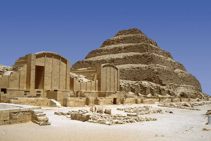
Image by Jon Bodsworth
The steps of this pyramid have been estimated to be inclined to the vertical in the range of 16°-18°. Recent measurements by Jon Bodsworth indicate a 17° angle of inclination. Measurements by Robert Bauval also indicate an angle of 17° with a margin of error of plus or minus 20'. An inclination of 17.172° (17° 10') to the vertical gives an inclination of 72.828° to the horizonal, the same as the through earth terrestrial triangles shown above:
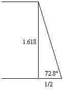
The 2φ ratio between the base and the height of the right triangle formed by the inclination of the pyramid steps is the same as the 2φ ratio between the half-base and the height of the through earth terrestrial triangles shown above.
10 miles southwest of Easter Island is a point along the great circle alignment that is equally distant at 10,071 miles from Giza and Angkor Vihear. Through earth lines from this point to Angkor and Giza are 7571 miles long. A great circle distance from Giza to Angkor of 4750 miles converts to a straight line distance of 4470.5 miles. The height of this straight line triangle is 7233.5 miles. The base angles of the triangle at Giza and Angkor are 72.828° and the φ ratio between the height and the base of the triangle is the same as the through earth triangles shown above: 4470.5 x 1.618 = 7233.5
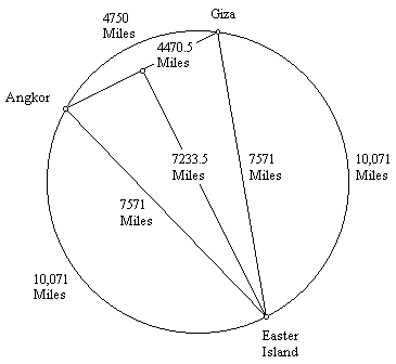
The straight line distance from Easter Island to Machupiccu is 2522 miles (great circle distance: 2566 miles). The straight line distance from Easter to it's antipodal point in the Indus Valley is 7924 miles (diameter of the great circle). The straight line distance from Easter to Giza is 7566 miles and the straigth line distance from Easter to Angkor Wat is 7574 miles.
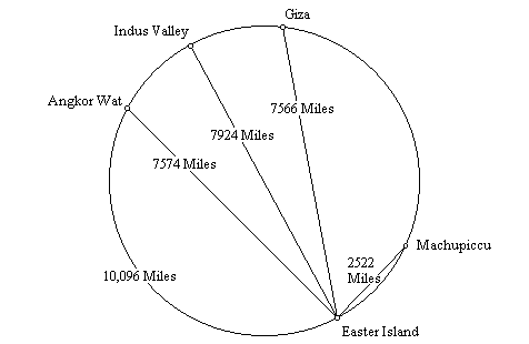
The straight line distance, through the Earth, from Angkor Wat to Easter (7,574 miles), plus the straight line distance from Easter to Macchupicchu (2,522 miles), equals the great circle distance from Angkor Wat to Easter (10,096 miles).
The straight line distance from the Great Pyramid to Easter (7,566 miles) is three times the straight line distance from Easter to Machupicchu (2,522 miles).
The straight line distance from Easter to its antipodal point in the Indus Valley (7,924 miles), which is also the diameter of the Earth, is 3.1416 times the straight line distance from Easter to Machupicchu (2,522 miles), a precise expression of π.
Since the circumference of the Earth is also 3.1416 times the diameter of the Earth, the straight line distance from Easter to Machupicchu times π² equals the circumference of the Earth.
|
|
|
|
Rispondi |
Messaggio 18 di 22 di questo argomento |
|
|
PART 9 - IN SEARCH OF ATLANTIS
The story of Atlantis is generally credited to Plato, even though he ascribed the story to much earlier Egyptian sources. According to those sources, the ancient, advanced Atlanteans ruled over islands and continents from an island kingdom outside of the Pillars of Hercules, which is thought to be the Straights of Gibralter. In Greek mythology, Atlas was the first king of Atlantis. Atlas had seven daughters known as the Atlantides. Because their mother was named Hesperis, they were also known as the Hesperides.
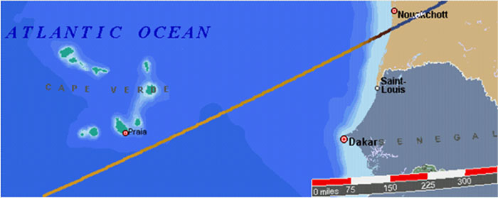
Machupicchu and the Great Pyramid are equally distant from the Cape Verde Islands. Easter Island and the Indus Valley are also equally distant from Cape Verde. When the Cape Verde Islands were rediscovered by European mariners in 1460 they were found to be uninhabited. However, islands in this location are found on earlier maps and described as inhabited in ancient times.
The Mecia de Viladestes map of 1413 shows islands in the location of Cape Verde labeled Gades. The information in this map is thought to have come from Roman sources dating back to the first century AD.
The discoveries of the world from their first originall unto the yeere of our Lord 1555, written by Antonio Galvao in 1563, lists the ancient names for the Cape Verde Islands as the Dorcades, Hesperides and the Gorgades. A 1587 map by Richard Hakluyt also labels the Cape Verde Islands as the Gorgades and the Hesperides.
According to Plato, there was a mountainous region north of the city of Atlantis. One possible location for Atlantis is in the Atlantic Ocean, just south of the Cape Verde Islands.
Arysio Nunes dos Santos proposed that Atlantis was originally located in the Bay of Bengal, just south of the mouth of the Ganges, and in the South China Sea. These areas were above sea level during the earth's last glaciation. The landmass that forms the shallow bottom of the South China Sea is the only known area on earth, large enough to meet Plato's description of the size of Atlantis, that sank at the end of the last ice age. Santos argues that scientific evidence, and references in ancient writings, folklore and myths, prove that the South China Sea and the Bay of Bengal were the original sites of Atlantis and Lemuria. Santos contends that a super eruption of Krakatoa in Atlantean times destroyed Atlantis and caused the end of the last ice age by covering the earth with volcanic ash which absorbed sunlight and melted the ice. The alignment of world wonders crosses over the Bay of Bengal, just south of the mouth of the Ganges, and goes right across the middle of the South China Sea. The halfway point betwen Mohenjo-Daro and Angkor is also located in the Bay of Bengal.
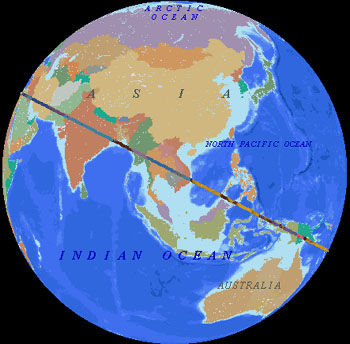
Another possible Atlantis location is halfway between the Great Pyramid and Easter Island, at 4° 19' north latitude, 41° 30' west longitude, under the Atlantic Ocean northeast of the mouth of the Amazon. On the diagram below, the marked locations are Giza, Angkor, Anatom Island, Easter Island, and 4° 19' north latitude, 41° 30' west longitude in the Atlantic Ocean. The distance from the Great Pyramid to Easter Island is approximately 40% of the circumference of the earth. The marked location in the Atlantic is halfway between the two, 20% each way. Machupicchu is halfway between Easter Island and the marked location in the Atlantic, 10% each way. The Distance from the Great Pyramid to Angkor Wat is approximately 20% of the circumference, and the Indus Valley is halfway between the two, 10% each way. The Distance from Easter Island to Angkor Wat is approximately 40% of the circumference, and Anatom Island is halfway between them, 20% each way. Although there are no islands in the Atlantic near 4° 19' north latitude, 41° 30' west longitude, it is interesting to note that the famous Piri Reis map shows a large island in this location, and the geology of recent core samples, taken from the ocean floor in this area, is of continental rather than oceanic type rock.
http://home.hiwaay.net/~jalison/concl.html |
|
|
|
Rispondi |
Messaggio 19 di 22 di questo argomento |
|
A THIRD EASTER ISLAND ALIGNMENT
Another great circle alignment of sacred sites diagramed by Terry Walsh includes Easter Island, Fatima, Filitosa, Rome, Mohenjo Daro and Bali. Constantinople, Hattusas, Van and Mehrgarh are also on this alignment.
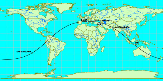
Image © Cosmi 3-D World Atlas
The axis points of this great circle are 48° 07' S, 15° 23' E and 48° 07' N, 164° 37' W. The great circle crosses the equator at 105° 23' E and 74° 37' W. The upper latitudes are 41° 53' N at 15° 23' E and 41° 53' S at 164° 37' W.
| Links: |
Latitude |
Longitude |
To Great Circle |
| Easter Island |
27° 06' S |
109° 20' W |
0 miles |
| Fatima |
39° 37' N |
8° 39' W |
15 miles |
| Filitosa |
41° 42' N |
8° 51' E |
0 miles |
| Rome |
41° 53' N |
12° 30' E |
0 miles |
| Constantinople |
41° 01' N |
29° 01' E |
0 miles |
| Hattusas |
40° 01' N |
34° 36' E |
11 miles |
| Van |
38° 30' N |
43° 22' E |
5 miles |
| Mehrgarh |
29° 30' N |
67° 40' E |
25 miles |
| Bali |
8° 10' S |
114° 38' E |
0 miles |
|
|
|
|
Rispondi |
Messaggio 20 di 22 di questo argomento |
|
El 5 de abril de 1722, el marino holandés Jacob Roggeveen, en busca de la mítica Tierra de Davis, llegó con sus navíos a una pequeña isla en mitad del océano Pacífico. Los europeos la bautizaron como isla de Pascua en honor al día de su llegada, la Pascua de Resurrección.3
1722=DESCUBRIMIENTO DE LA ISLA DE PASCUA
7/22 (AMERICANO)=22/7 (DIA DE MARIA MAGDALENA)
NO PEGAS UNA UNGIDO
TODO ESTA CODIFICADO
¿sos aleman ungido o te lo han hecho creer?
con todo respeto
|
|
|
|
Rispondi |
Messaggio 21 di 22 di questo argomento |
|
PI-N-OCHET (PI-OCHO)=22/7=LEVITICO 23:33
|
|
|
|
Rispondi |
Messaggio 22 di 22 di questo argomento |
|
|
|
 Primo
Precedente
8 a 22 de 22
Successivo Primo
Precedente
8 a 22 de 22
Successivo
 Ultimo
|
|
| |
|
|
©2026 - Gabitos - Tutti i diritti riservati | |
|
|


")


")
")