|
|
Tel Dan

Tel Dan: Muro sur de la ciudad.
Tel Dan ("Monte de Dan", תל דן en hebreo), también conocida como Tel el-Qadi (Monte del juez en árabe, تل القاضي), es un yacimiento arqueológico en Galilea, Israel, próximo a las alturas del Golán, seguramente sobre la antigua ciudad bíblica de Dan, límite norte delReino de Israel, conocida como Laís en el Libro de los Jueces antes de su conquista por la tribu de Dan.
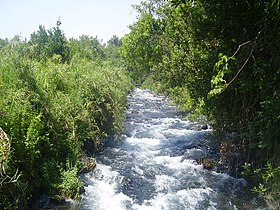
Aguas del río Dan, tributario del Jordán, en las cercanías de Tel Dan
Al oeste de Dan se encuentran las montañas meridionales de la cordillera del Líbano, mientras que al este y al norte están el monte Hermón. El derretimiento de la nieve de Hermón proporciona la mayor parte de agua del río Jordán a través de un afluente, el río Dan, haciendo al área de Tel Dan altamente fértil. La exuberante vegetación resultante hace que la zona que rodea a Dan parezca un tanto fuera de lugar comparada con la región árida a su alrededor.
Historia de Dan[editar]
Periodo pre israelita[editar]
De acuerdo con los restos arqueológicos hallados, la ciudad de Dan fue ocupada originalmente a finales del Neolítico (ca. 4500 a.C), aunque en algún momento del cuarto milenio antes de Cristo fue abandonada, abandono que duró cerca de 1000 años.
Según el Libro de los Jueces, antes que la tribu de Dan ocupara los terrenos, la ciudad fue conocida como Laís, y forjó una alianza con la ciudad de Sidón, lo que presumiblemente indica que los habitantes de Dan eran fenicios.1 Esta alianza tuvo escasos beneficios prácticcos, debido a la distancia entre Dan y Sidón, acrecentada por estar separadas por la cordillera del Líbano. Asimismo, a causa de las montañas de Hermón, la ciudad también se aisló de los asirios y de los arameos;3 laSeptuaginta menciona que la ciudad fue incapaz de hacer una alianza con los arameos. El texto masorético no menciona los arameos, pero afirma en cambio que la ciudad no tenía "relaciones con ningún hombre", aunque los ríticos textualescreen que se trata de un error tipográfico, entendiendo Adham (hombre) en vez de Aram (arameos).4
Ocupación por la tribu de Dan[editar]
De acuerdo con la narración del Libro de los Jueces sobre el ídolo de Miqueas,5 la tribu de Dan no tenía en ese momento ningún territorio israelita a su nombre,6 por lo que, después de explorar el territorio, decidieron finalmente atacar la ciudad de Laís para capturarla, ya que la tierra alrededor de ella era fértil, la ciudad estaba desmilitarizada y no tenía alianzas políticas lo suficientemente efectivas.
La mayoría de los eruditos bíblicos creen que la tribu de Dan era uno de los llamados Pueblos del Mar, por lo que se mantuvieron en sus embarcaciones a inicios del canto de Débora, y no tenían tierras israelitas propias,7 8 aunque algunos eruditos conservadores argumentan que la tribu de Dan fue continuamente migrando debido que fueron expulsados de sus tierras originales por los filisteos.
La narración en Jueces describe a la tribu de Dan derrotar brutalmente al pueblo de Laís y quemando la ciudad por completo, tras lo cual construyeron su propia ciudad en el mismo lugar. Sin embargo, los eruditos textuales creen que el relato entero sobre el ídolo de Miqueas es una "mancha" en la historia del santuario de Dan, hecha por uno o más escritores que se oponían a la presencia de ídolos, y que, por lo tanto, la brutalidad aparente con que se describe a los danitas puede no reflejar la realidad histórica.9 ] El relato afirma que Laís luego fue rebautizada como Dan, y que tenía unsantuario lleno de ídolos,10 que se mantuvo en uso hasta la época en que fue capturada la ciudad, mientras que la casa de Dios dejó de estar en Siló. Los estudiosos creen que lo primero se refiere a la conquista asiria del Reino de Israel porTiglatpileser III en 733/732 a.C, y que lo último se refiere al tiempo de la reforma religiosa de Ezequías;11 otra posibilidad, sin embargo, apoyada por una minoría de estudiosos, es que la época en que fue capturada la ciudad es un error tipográfico y debería decir el tiempo de cautiverio del arca, en referencia a la batalla de Eben-Ezer, y la captura filistea del Arca, y que el cese de la casa de Dios en Siló también se referiría a esto.12
Reino de Israel[editar]
Según el Libro de los Reyes, Jeroboam I estableció dos ídolos de oro en forma de becerros: uno en Dan por el norte, y otro en Betel por el sur.13 Algunos estudiosos creen que aquí es donde se origina en realidad la historia elohísta del becerro de oro de Aarón, debido a la oposición en algunos sectores de la sociedad israelita (incluidos los propios elohístas) al ídolo de aparente culto de Jeroboam.14 Sin embargo, estudiosos de la Biblia creen que Jeroboam estaba tratando de superar al santuario de Jerusalén (Templo de Salomón), mediante la creación de una sede de Dios que se extendiera por todo el reino de Israel, y no sólo un pequeño espacio por encima del Arca de la Alianza en Jerusalén. La sede de Dios en el santuario de Jerusalén tenía un querubín a cada lado, mientras que los estudiosos creen que Jeroboam estaba usando los becerros para representar los dos lados de su sede destinada a Dios - lo que implicaría que todo su reino era igual en santidad a la Arca15
Dan sufrió durante la era de la expansión de los arameos, por ser la ciudad israelita más cercana a ellos. Las distintas incursiones señaladas en el Libro de los Reyes sugieren que Dan cambió de manos por lo menos cuatro veces entre el reino de Israel y los arameos, en el tiempo que Israel estaba gobernada por Ajab y el rey de los arameos era Ben Hadad I y sus sucesores. Alrededor de este tiempo, la estela de Tel Dan fue creada por los arameos, durante uno de los períodos de su control de la ciudad de Dan. Cuando el imperio asirio se expandió hacia el sur, el reino de Israel llegó a ser inicialmente un estado vasallo, pero después de rebelarse, los asirios invadieron la ciudad, que cayó definitivameente a manos de Tiglatpileser III en 733/732 a.C.
Descubrimientos arqueológicos de Tel Dan[editar]
Los descubrimientos en el sitio de Tel Dan datan del Neolítico, circa 4500 a. C, y los restos encontrados incluyen desde paredes de 0,8 m de ancho hasta fragmentos de cerámica. Según parece, el sitio fue ocupado en el Neolítico por varios siglos antes de ser abandonado por cerca de 1000 años.
Dentro de los restos del muro de la ciudad, cerca del pórtico exterior, se encontró un fragmento que aparentemente correpondería a una estela. Este fragmento de basalto, conocido como Estela de Tel Dan, contiene una inscripción en arameo que se referiría a uno de los reyes arameos deDamasco, Hazael (c 840 a. C), aunque algunos estudiosos creen que se refiere a Ben-Hadad (c 802 a. C). Muy poco de la inscripción se mantiene, pero el texto contiene las letras 'ביתדוד' (BYTDWD) que algunos arqueólogos creen que quiere decir Casa de David (Beth David en hebreo). En la línea inmediatamente superior, se lee el texto 'MLK YSR'L', i.e. "Melek Yisrael" o sea "Rey de Israel" en hebreo (los escritos hebreos tanto de la época como de hoy no poseen vocales).
En 1992, con el fin de poner en orden el lugar para su apertura al público en general, se removió un montón de escombros que databan del tiempo en que los asirios destruyeron la ciudad (733/2 a.C). Inesperadamente, una puerta de enlace a la ciudad, desconocida hasta entonces, fue descubierta. La entrada conducía a un patio empedrado donde había una plataforma de piedra, la que ha sido identificada por algunos literalistas bíblicos como el podio para el becerro de oro que, de acuerdo a la Biblia ,fue colocada por Jeroboam I.16 17
La Puerta de Abraham[editar]
Las excavadoras de Tel Dan descubrieron una puerta de la ciudad hecha de ladrillos de barro, que se estima construida alrededor del 1750 a. C., en el período de los patriarcas bíblicos. Su nombre popular es la "Puerta de Abraham", porqueAbraham viajó a Dan para rescatar a su sobrino Lot. Génesis 14:14: "Y cuando oyó Abram que su pariente estaba prisionero, armó a sus criados, nacidos en su propia casa, trescientos dieciocho, y los condujo hasta Dan." La puerta se ha convertido en una atracción turística.18 La Puerta de Abraham fue restaurada completamente a fines de los años 2000.19
Referencias[editar]
https://es.wikipedia.org/wiki/Tel_Dan
|
|
|
|
|

 
  ![Stargate Special Edition [Reino Unido] [DVD]: Amazon.es: Kurt Russell: Películas y TV](https://m.media-amazon.com/images/I/51Gr2lgt03L.jpg)
LA SANGRE DEL CORDERO EN EL DINTEL, EN CONTEXTO AL EXODO PASCUAL, ES UN TIPO DEL GRIAL
1. Éxodo 12:7: Y tomarán de la sangre, y la pondrán en los dos postes y en el DINTEL de las casas en que lo han de comer.
2. Éxodo 12:22: Y tomad un manojo de hisopo, y mojadlo en la sangre que estará en un lebrillo, y untad el DINTEL y los dos postes con la sangre que estará en el lebrillo; y ninguno de vosotros salga de las puertas de su casa hasta la mañana.
3. Éxodo 12:23: Porque Jehová pasará hiriendo a los egipcios; y cuando vea la sangre en el DINTEL y en los dos postes, pasará Jehová aquella puerta, y no dejará entrar al heridor en vuestras casas para herir.
Dintel
De Wikipedia, la enciclopedia libre

Esquema de estructura adintelada.
Un dintel es un elemento estructural horizontal que salva un espacio libre entre dos apoyos. Es el elemento superior que permite abrir huecos en los muros para conformar puertas, ventanas o pórticos. Por extensión, el tipo de arquitectura, o construcción, que utiliza el uso de dinteles para cubrir los espacios en los edificios se llama arquitectura adintelada, o construcción adintelada. La que utiliza arcos o bóvedas se denomina arquitectura abovedada.
Los mejores exponentes de arquitectura adintelada en piedra son los edificios monumentales del Antiguo Egipto y la Grecia clásica. La palabra dintel proviene de la palabra latina: limitellus, que deriva etimológicamente de limen y limes. En latín la palabra limen significa umbral, puerta, entrada o comienzo, y limes se refiere a un sendero entre dos campos, límite o muralla.
Comparen las dos figuras anteriores y noten que la LUZ SOLAR PENETRA, en este caso EN LA PUERTA DE TIWANAKU (BOLIVIA) en los equinoccios, osea el 20/21 de marzo y los 21/22 de septiembre. CONCRETAMENTE LA FIESTA DE LOS TABERNACULOS ES PRIMA HERMANA DE LA FIESTA PASCUAL. EN ESTE MARCO, INSISTO, EL SOL, SI USTED COMPARA CON LA FIGURA SUPERIOR, EN LOS MISMOS EQUINOCCIOS LA LUZ SOLAR CHOCA CON LA PIRAMIDE VATICANA E INCLUSO INGRESA O PENETRA ADENTRO DEL TEMPLO DE SAN PEDRO. PREGUNTO: ¿SI LA PLAZA DE MARIA DE LA VICTORIA ESTA UBICADA EN LA MISMA LINEA EQUINOCCIAL, QUIEN ES EN ESTE MARCO LA MISMA, EN EL CONTEXTO QUE LA PASCUA TAMBIEN TIENE ESA REFERENCIA? CUALQUIER PERSONA QUE TIENE TRES DEDOS DE FRENTE SE DA CUENTA QUE ES MARIA LA MAGDALENA. SI NO ES ASI PREGUNTO:
¿PORQUE CRISTO SE PRESENTO SIENDO VENCEDOR EL 17 DE NISSAN, OSEA EN EL EQUINOCCIO FRENTE A MARIA MAGDALENA?
CONCLUYO:
MARIA LA VICTORIA ES MARIA MAGDALENA
 |
|
|
|
|
I've recently started a site, the info you offer on this site has helped me tremendously. Thank you for all of your time & work.
|
|
|
|
|

Jordan River (Utah)
From Wikipedia, the free encyclopedia
The Jordan River, in the state of Utah, United States, is a river about 51 miles (82 km) long. Regulated by pumps at its headwaters at Utah Lake, it flows northward through the Salt Lake Valley and empties into the Great Salt Lake. Four of Utah's six largest cities border the river: Salt Lake City, West Valley City, West Jordan, and Sandy. More than a million people live in the Jordan Subbasin, part of the Jordan River watershed that lies within Salt Lake and Utah counties. During the Pleistocene, the area was part of Lake Bonneville.
Members of the Desert Archaic Culture were the earliest known inhabitants of the region; an archaeological site found along the river dates back 3,000 years. Mormon pioneers led by Brigham Young were the first European American settlers, arriving in July 1847 and establishing farms and settlements along the river and its tributaries. The growing population, needing water for drinking, irrigation, and industrial use in an arid climate, dug ditches and canals, built dams, and installed pumps to create a highly regulated river.
Although the Jordan was originally a cold-water fishery with 13 native species, including Bonneville cutthroat trout, it has become a warm-water fishery where the common carp is most abundant. It was heavily polluted for many years by raw sewage, agricultural runoff, and mining wastes. In the 1960s, sewage treatment removed many pollutants. In the 21st century, pollution is further limited by the Clean Water Act, and, in some cases, the Superfund program. Once the home of bighorn sheep and beaver, the contemporary river is frequented by raccoons, red foxes, and domestic pets. It is an important avian resource, as are the Great Salt Lake and Utah Lake, visited by more than 200 bird species.
Big Cottonwood, Little Cottonwood, Red Butte, Mill, Parley's, and City creeks, as well as smaller streams like Willow Creek at Draper, Utah, flow through the sub-basin. The Jordan River Parkway along the river includes natural areas, botanical gardens, golf courses, and a 40-mile (64 km) bicycle and pedestrian trail, completed in 2017.[6]
The Jordan River is Utah Lake's only outflow. It originates at the northern end of the lake between the cities of Lehi and Saratoga Springs. It then meanders north through the north end of Utah Valley for approximately 8 miles (13 km) until it passes through a gorge in the Traverse Mountains, known as the Jordan Narrows. The Utah National Guard base at Camp Williams lies on the western side of the river through much of the Jordan Narrows.[7][8] The Turner Dam, located 41.8 miles (67.3 km) from the river's mouth (or at river mile 41.8) and within the boundaries of the Jordan Narrows, is the first of two dams of the Jordan River. Turner Dam diverts the water to the right or easterly into the East Jordan Canal and to the left or westerly toward the Utah and Salt Lake Canal. Two pumping stations situated next to Turner Dam divert water to the west into the Provo Reservoir Canal, Utah Lake Distribution Canal, and Jacob-Welby Canal. The Provo Reservoir Canal runs north through Salt Lake County, Jacob-Welby runs south through Utah County. The Utah Lake Distribution Canal runs both north and south, eventually leading back into Utah Lake.[9] Outside the narrows, the river reaches the second dam, known as Joint Dam, which is 39.9 miles (64.2 km) from the river's mouth. Joint Dam diverts water to the east for the Jordan and Salt Lake City Canal and to the west for the South Jordan Canal.[10][11][12]

Map of the Salt Lake Valley
The river then flows through the middle of the Salt Lake Valley, initially moving through the city of Bluffdale and then forming the border between the cities of Riverton and Draper.[7] The river then enters the city of South Jordan where it merges with Midas Creek from the west. Upon leaving South Jordan, the river forms the border between the cities of West Jordan on the west and Sandy and Midvale on the east. From the west, Bingham Creek enters West Jordan. Dry Creek, an eastern tributary, combines with the main river in Sandy. The river then forms the border between the cities of Taylorsville and West Valley City on the west and Murray and South Salt Lake on the east. The river flows underneath Interstate 215 in Murray. Little and Big Cottonwood Creeks enter from the east in Murray, 21.7 miles (34.9 km) and 20.6 miles (33.2 km) from the mouth respectively. Mill Creek enters on the east in South Salt Lake, 17.3 miles (27.8 km) from the mouth. The river runs through the middle of Salt Lake City, where the river travels underneath Interstate 80 a mile west of downtown Salt Lake City and again underneath Interstate 215 in the northern portion of Salt Lake City. Interstate 15 parallels the river's eastern flank throughout Salt Lake County. At 16 miles (26 km) from the mouth, the river enters the Surplus Canal channel. The Jordan River physically diverts from the Surplus Canal through four gates and heads north with the Surplus Canal heading northwest. Parley's, Emigration, and Red Butte Creeks converge from the east through an underground pipe, 14.2 miles (22.9 km) from the mouth.[7] City Creek also enters via an underground pipe, 11.5 miles (18.5 km) from the river's mouth. The length of the river and the elevation of its mouth varies year to year depending on the fluctuations of the Great Salt Lake caused by weather conditions. The lake has an average elevation of 4,200 feet (1,300 m) which can deviate by 10 feet (3.0 m).[3] The Jordan River then continues for 9 to 12 miles (14 to 19 km) with Salt Lake County on the west and North Salt Lake and Davis County on the east until it empties into the Great Salt Lake.[7][8][11]
Discharge[edit]
The United States Geological Survey maintains a stream gauge in Salt Lake City that shows annual runoff from the period 1980–2003 is just over 150,000 acre-feet (190,000,000 m3) per year or 100 percent of the total 800,000 acre-feet (990,000,000 m3) of water entering the Jordan River from all sources. The Surplus Canal carries almost 60 percent of the water into the Great Salt Lake, with various irrigation canals responsible for the rest. The amount of water entering the Jordan River from Utah Lake is just over 400,000 acre-feet (490,000,000 m3) per year. Inflow from the 11 largest streams feeding the Jordan River, sewage treatment plants, and groundwater each account for approximately 15 percent of water entering the river.[13]
Watershed[edit]

Map of the entire Jordan River Basin
|
|
|
|
|
Astronomical alignment[edit]
Looking east through nave on 23 June 1976, two days after the summer solstice Mary Magdalene's relics in the crypt
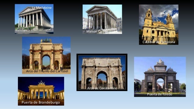
In 1976, Hugues Delautre, one of the Franciscan fathers charged with stewardship of the Vézelay sanctuary, discovered that beyond the customary east-west orientation of the structure, the architecture of La Madeleine incorporates the relative positions of the Earth and the Sun into its design. Every June, just before the feast day of Saint John the Baptist, the astronomical dimensions of the church are revealed as the sun reaches its highest point of the year, at local noon on the summer solstice, when the sunlight coming through the southern clerestory windows casts a series of illuminated spots precisely along the longitudinal center of the nave floor.[13][14][15][16][17]
|
|
|
 Primer
Anterior
43 a 57 de 57
Siguiente Primer
Anterior
43 a 57 de 57
Siguiente
 Último
|


![That's one small step..." —Neil Armstrong [1024 x 1333] : r/QuotesPorn](https://i.imgur.com/lfLGX.jpg)