|
|
|
RELACION DEL 33 CON EL GRIAL
|
|
|
|
|
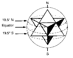
Spherical Geometry & 19.5 Degrees
throughout the solar system
NEXT: The Piri Reis map
19.5 degrees north and south are the latitudes
where the apex points of a star tetrahedra within a sphere
will contact that sphere's surface,
when one apex is positioned at the north or south pole.
On the Sun: sunspot activity and the region of peak temperatures is limited to 19.5 degreees north and south.
On Venus: the presumably active major volcano complexes Alpha and Beta Regio are near 19.5 degrees.
On Earth:
Mauna Loa, Hawaii (19 degrees 28 minutes N, 155 degrees 37 minutes W) The largest shield volcano is at 19.6 degrees north. This is Mauna-Kea volcano on the island of Hawaii.
Mexico City, Mexico (19 degrees 23 minutes N, 99 degrees 10 minutes W) The Pyramid of the Sun at Teotihuacan is at 19.6 degrees north.
Dzibalchen, (Yucatan), Mexico (19 degrees 28 minutes N, 89 degrees 46 minutes W)
Georgetown, Grand Cayman Island (19 degrees 18 minutes N, 81 degrees 26 minutes W)
Mount Emi Koussi, Chad, Africa (19 degrees 47 minutes N, 18 degrees 34 minutes E)
Mount Kalsubai, (near Bombay), India (19 degrees 33 minutes N, 73 degrees 43 minutes E)
Mountain near Xiangkhoang, Laos (19 degrees 17 minutes N, 103 degrees 17 minutes E)
Mountain near Potosi, Bolivia (19 degrees 13 minutes S, 66 degrees 22 minutes W)
Yasur Volcano, Tanna Island, Vanuatu (South Pacific Ocean) (19 degrees 31 minutes S, 169 degrees 25 minutes E)
Mount Samuel, Northwest Territory, Australia (19 degrees 13 minutes S, 134 degrees 8 minutes E)
Gweru, Zimbabwe, Africa (19 degrees 31 minutes S, 29 degrees 49 minutes E)
On Mars: the "vast" Olympus Mons shield cone volcano is at 19.5 degrees.
On Jupiter: the "red spot" which is an obvious vortex is at 19.5 degrees.
On Neptune: in 1986 Voyager II discovered a similar spot at 19.5 degrees north.
Based on Richard Dannelley's book, Sedona: Beyond the Vortex and Bruce Rawles
Why '19.5 degrees' is Significant
19.5 degrees is the angle that's been found by researchers (Richard C. Hoagland, Stanley McDaniel, Erol Torun, Horace W. Crater, etc.) to be repeatedly encoded in the structures of Cydonia. It is viewed as a definite 'signal in the noise' - some kind of a 'message' left there by some intelligence. 19.5 is called t, the 'tetrahedral constant', because of its significance in tetrahedral geometry (a tetrahedron is a pyramid shape composed of four equilateral triangular sides): the apexes of a tetrahedron when placed within a circumscribing sphere, one of the tetrahedron's apexes touching the north pole, the other three apexes touch the surface of the sphere at 19.5 degrees south latitude. Why this number would be important to the builders of the Martian structures is not clear (though Hoagland is theorizing that it has to do with what he calls "hyperdimensional physics").
Nile Time-Map & tetrahedral geometry -- 19.5 degrees
http://prophetic.simplenet.com/elysium/nile-timemap.htm
The emphasis on 19.5 degrees is not confined to the Martian structures. It has been found to be associated with various ancient structures here on earth - Giza pyramids, Avebury (the largest stone circle in the world, near Stonehenge), Pyramids of the Sun and Moon at Teotihuacan, etc. It is also worth noting that the Egyptian hieroglyph for Sirius, the brightest star in the sky which was extremely important to ancient Egyptians, is an equilateral triangle which can be viewed as a 2-dimensional representation of a tetrahedron; and in the Egyptian translation, it means a doorway... a sort of 'stargate'. Curiously, it has also been observed that 19.5 degrees is closely linked, for some reason, with the NASA space missions (for example, Mars Pathfinder landed at 19.5 degrees lat. of Mars on July 4, '97). In fact, not only did Pathfinder landed at 19.5 N, the longitude of the landing site was approximately 33 W - which is the very number of the longitude of the apex of the Great Bend of the Nile (33 E)! Now, this strongly insists on the relevance of the Nile numbers, and someone behind the scenes is well aware of it. As we move on, the number, 19.5, will also be very important in my Nile Time-map theory. Perhaps, as the Nile-Mars connection bridged by '19.5' appears to suggest, Mars was somehow involved during the 'Prometheus / Pandora period'.
http://www.vortexmaps.com/planets.php |
|
|
|
|
Haz hecho público que te gusta. Deshacer
Haz hecho público que te gusta. Deshacer
Haz hecho público que te gusta. Deshacer
Haz hecho público que te gusta. Deshacer
Haz hecho público que te gusta. Deshacer
Haz hecho público que te gusta. Deshacer10 entradas - 3 autores - 24 May 2009
Los masones de la NASA en el 97 enviaron el Pathfinder tetraédrico a aterrizar en Marte a la latitud 19.5 Norte y 33 Oeste mientras la Tierra ...
article.wn.com/.../ESO_Uranium_Drilling_Returns_195_Meters_of_...En caché
Haz hecho público que te gusta. Deshacer
Haz hecho público que te gusta. Deshacer
Haz hecho público que te gusta. Deshacer
www.oarval.org/mpfmarssp.htm - Estados UnidosEn caché
Haz hecho público que te gusta. Deshacer
|
|
|
|
|
Mars Pathfinder Landing Site ...
A Sphinx Revisited?
By
Mike Bara
"Still, we cannot deny that the act of placing a
tetrahedral object on Mars at latitude 19.5 contains all the necessary
numbers & symbolism to qualify as a "message received" signal in response to
the geometry of Cydonia. Moreover, such a game of mathematics & symbolism is
precisely what we would expect if NASA were being influenced by the type of
occult conspiracy that Hoagland, for one, is always trying to espouse."
-- Graham Hancock, "The Mars Mystery -- The Secret
Connection Between Earth and the Red Planet"
When Mars Pathfinder bounced to a halt on its innovative airbags after it's unprecedented straight in, meteor-like decent to the Martian surface on July 4th, 1997, most of us were convinced - watching its initial panoramas -- that we were simply looking at another boring Martian desert filled with rocks -- just like the scenes relayed from the previous Viking Lander missions some twenty years earlier. Overshadowed by Enterprise principal investigator Richard C. Hoagland's highly advertised political prediction -- that the Pathfinder Lander would be diverted to Cydonia, instead of arriving at its announced touchdown point a thousand miles away -- many of us in the "anomalist community" were initially distracted from viewing those first Pathfinder images in any great detail.
At the time of the Pathfinder landing, I did not know Hoagland well; we had yet to begin a formal collaboration on our now highly successful "reverse engineered" model of NASA's extraordinary (and now extraordinarily well documented) "Egyptian ritual obsession." Hoagland's high-profile mistake on Pathfinder, after years of additional analysis, is understandable in retrospect -- given the (deliberate?) "mixed messages" carefully promoted at the time around JPL's actual Pathfinder landing (see below).
One of the things that threw Hoagland was the sky above that landing site: looked at before the actual July 4th arrival, it did not correspond at all to the stellar pattern he'd found throughout NASA's previous manned and unmanned missions; at the announced time of Pathfinder's projected landing, the key "ritual star," Sirius, and the critical "Belt stars of Orion," would not be in their expected "ritual positions" (19.5° or 33°) above or below the horizon; or, on the horizon or meridian. By sharp contrast, the sky at Cydonia did fit - not for July 4th, but for the "perfect" ritual date, July 20th. (It wasn't until about a year later that continuing analysis revealed previous "commemoration" patterns - alignments "celebrated" for one landing site on a particularly auspicious date, but conducted at another landing site or "temple" -- on many prior missions.)

In hindsight, paradoxically, it turned out that Hoagland was simply looking in the wrong direction: instead of looking at the stars above the site, he should have been looking at the announced landing site itself -and then have focused on those clues. For its choice could not ultimately have been more "symbolic," or more embedded in NASA's amazingly consistent pattern: 19.5° N Lat. by 33° W Long! As the first tetrahedral spacecraft flown to Mars, Pathfinder itself embodied precisely those same circumscribed tetrahedral mathematical parameters, carefully "telegraphed" by NASA's choice of the "Ares Vallis" landing site - as "33," besides its other tetrahedral qualities, is none other than the sin of 19.5 degrees!
Such a remarkable mathematical "coincidence" for Pathfinder had to have been (by "someone") carefully designed.

Thus, if Hoagland hadn't focused public attention on a possible "clandestine Pathfinder mission to Cydonia" (through his, it turned out, erroneous misreading of some stellar indicators), no one would have paid attention to this stunning -- but completely unexpected -- ultimate confirmation of his larger "NASA pattern" in the actual Mars landing! Pathfinder's unique tetrahedral spacecraft design geometry, coupled with the totally "recursive" tetrahedral geometry of the landing site itself, was obviously intended by NASA "ritualists" behind the scenes to celebrate - on their first return to Mars in over twenty years -- the two key Hyperdimensional numbers underlying all the NASA rituals - "19.5" and "33."
And, by his own admission, that crucial confirmation made Hoagland's initial political "mistake" supremely worth it.
Thus forewarned -- that "something" about Pathfinder's actual July 4th Ares Vallis target was considered very special, not just by the geologists who ostensibly picked this landing site but by these ritual "believers" somehow quietly controlling the entire Mission -- Hoagland alerted other members of the Enterprise team to focus heavily upon the next phases of the Mission. Within hours after it's successful touchdown, Pathfinder -- according to a pre-loaded on-board computer program -- began to transmit image after image of the scene around the landing, far more (it inexplicably turned out) than "originally programmed." And, unlike JPL's pre-announcements, the images were not just "looking down at the edges of the spacecraft solar panels and the airbags" - but were of the entire panorama … from the spacecraft to the distant red horizon. It was in those first, unplanned and totally uncensored images, that several startling features - clearly NOT belonging on a "lifeless desert world" - unquestionably could be seen … and not just by Hoagland, but by the literally millions watching "live on CNN."
Hoagland, alerted by the extraordinary numerical "coincidence" of the spacecraft/pre-planned landing site geometry, had planned his own careful taping of all the live transmission of those first (even just a few) uncensored scenes. Enterprise Mission consulting geologist, Ron Nicks, also began looking … and started seeing major "inconsistencies" about the landing site as the unexpected panoramas swept across the screen: blatantly geometric "anomalies" around the Lander, showing up on CNN's television broadcasts. Worldwide viewers, also watching live on CNN, began calling in about "the strangely geometric rocks" that they were seeing in the flood of images. The number of calls was so significant that CNN's science anchor, the late John Holliman, eventually felt compelled to ask one of the Pathfinder scientists about it on the air.
Meanwhile, Nicks and Hoagland, taking careful notes and taping everything, quickly realized that what they were seeing was not the expected "wind or water eroded rocks" of Ares Vallis -- but a debris field filled with a variety of apparently corroded metal objects, "canisters" with opposable handles, shimmering glass-like geometric structures … and even a couple of deformed but recognizable tracked vehicles. A totally separate research effort, the Near Pathfinder Anomaly Analysis Group (NPAA), also sprang up - triggered by the same anomalous images appearing live on CNN.
But, after the initial - and still totally unexplained -- windfall of those first "hundred or so live images on CNN" (perhaps from a whistleblower deep in the Mission planning team?), the post landing analysis of these remarkable anomalies was immediately frustrated by the maddening (and also inexplicable) lack of clear Pathfinder images, subsequently made available across the Web from JPL.
Over twenty years had elapsed, between Viking's literally mechanical facsimile surface cameras in 1976 and Pathfinder's state-of-the-art CCD imaging technology of 1997. But, judging by the digital Pathfinder photographs publicly available from JPL -- you'd never know it! Unusual (and still unresolved) discrepancies were found repeatedly, between the original (much clearer) initial television transmissions from CNN's live Pathfinder feed that July 4th afternoon, and the later electronic versions of those same images released by JPL.

The simple truth was that the processed Internet digital files should have been much sharper than the original "raw" data feed coming from Pathfinder that first afternoon - especially, after rebroadcast over live TV. Instead, JPL's Web versions were full of astonishingly amateurish compression artifacts, assembly errors, and blatant color registration problems. JPL even "adjusted" the color of the Martian sky to appear the traditional "Viking pink" -- instead of the forecast (from concurrent Hubble imagery) natural Earth-like blue.
The implications of this blatant image tampering and crude manipulation were as abhorrent as they were sickeningly obvious (to everyone but the mainstream press, that is): JPL was clearly trying to hide (and not too well, for some reason … more "whistle blowing?") "something" in these images. It soon became obvious exactly "what."
Besides all the "near field" Pathfinder anomalies, Nicks and Hoagland began studying "super resolution" images of the two distant (almost one kilometer) "mountains" imaged on the horizon of the Landing Site: the celebrated "Twin Peaks." Nicks, in particular, soon realized that these features showed definite signs of engineering, as opposed to natural erosional processes. And, although he recognized that the area (as NASA had previously advertised) obviously had been subjected to "a brief but catastrophic flood," he could not explain some of the strikingly geometric features he was seeing on the "Peaks" as "just geology." There were obvious, repeating block-like structures (particularly on South Peak - see below), and some very unusual orthogonal (right angle) three-dimensional layering on the exposed ("downstream") surfaces.

The "Twin Peaks" seemed have the definite geometric shapes of pyramids -- but highly eroded pyramids (especially the North Peak) -- which apparently had had some of their casing literally ripped off in that same massive flood that had devastated the entire area countless millennia before. The debris field in the foreground, which had initially captured Hoagland and Nicks' attention, consisted of a myriad of objects possessing multiple sharp "points" and edges. They could not therefore be merely "water eroded (or water tumbled) rocks." They obviously had to be made of much harder materials - potentially artificial objects and even metallic machinery, ripped from the exposed interiors of the not-so-distant, exposed-"arcologies" - including, probably, remnants of the technology that actually built them!
All of which was quite fascinating ... and ultimately irresolvable. For, without better resolution images from future rover missions, or cleaned up versions of the Pathfinder originals (as opposed to the degraded and obviously "sanitized" versions placed by NASA on the Web), there was really not much more that we could do to prove the artificial nature of the region.
Until now.
Using a technique called "Super Resolution Surface Modeling," in the several years since Pathfinder, NASA scientists have been able to take multiple images of the Pathfinder landing site and enhance them well beyond their original resolving capability. Recently, a reader, Giuseppe Pezzella from Naples, Italy, pointed me to the official NASA image archive for these "super resolution" images. After downloading a few, it quickly became apparent that something - completely unnoticed at the time, and even more interesting (if that's possible) than the potential nearby artifacts analyzed by Nicks and Hoagland -- might have been imaged on the Martian landscape … between South Peak and Pathfinder itself (below).
What had been merely a huge "blocky shape" on the original scenes, suddenly emerged as "recognizable" on the new, highly processed images. I did a "double take" on the shape Giuseppe pointed out ...

... A Sphinx!
Given Hoagland's now strikingly confirmed "leonine" dual Face image lying at Cydonia, my mouth basically dropped open when I saw this other, "eerily familiar shape" crouching there in front of Pathfinder's "South Peak Pyramid." It struck me as not only of the right size and form for nothing less than a Great Martian Sphinx (!) -- but it was in the right position as well (out in front of the background Pyramid!). It lay some distance from the Pathfinder Lander, at the edge of the previously mapped debris field … near the base of South Peak. And -- like its counterpart on Earth -- also faced East … directly toward the Martian equinoctial sunrise. There were even a couple of what appeared to be "vertically-faced buildings" to the left of this potential "Martian Sphinx"; they could easily be viewed as "a temple," or a distant entrance to the background Pyramid Arcology itself.
In ancient Egypt, Sphinxes were used to "guard" temples, tombs and monuments. The grandest example of these, and probably the earliest on Earth, is the Great Sphinx at Giza -- forever guarding the three Great Pyramids on the Plateau. As a Sphinx carries out this task, it is always in the same repose: lying flat on its stomach … forepaws extended outward … ready to "pounce" into action at a moment's notice. Sphinxes invariably have the head of man (or woman?), to go with their lion's body. The head, in turn, is framed by the characteristic banded "nemes" headdress (which is meant, of course, to signify the lions mane).

Even from this compressed narrative perspective, you can see in these NASA-enhanced close-ups (above) that this Martian Sphinx has all the classic earmarks of its Egyptian counterpart: there are two attached and extended "forepaws"; a body (complete with what looks to be a feline hind leg); and a very clear rounded Face, encompassed by a symmetrical nemes-like Pharaohic "headdress!" The Headdress even has two opposing angles just below the "chin" - extending outward at about a 45° angle. These characteristics alone -- the extended symmetrical paws, and the rounded Face framed by that familiar headdress - coupled with its context, lying to the East of a strikingly pyramidal-looking structure, would normally be enough to call this formation's natural genesis into serious question. But when you view it side-by-side with its counterpart on Earth -- the Giza Sphinx itself -- the resemblance is totally uncanny ...

And remember - this "Martian Sphinx" is guarding an obvious "pyramid" on Mars … at 19.5° N Latitude by 33° W Longitude ...

When you consider all these factors -- the current man/lion hybrid symbolism now amply confirmed elsewhere on Mars (Cydonia); the unusual, suspiciously "manufactured" and "pyramid-like" characteristics of the "Twin Peaks"; and the striking similarity of their "attending figure" to the renowned Giza feline monument itself -- it becomes somewhat obvious that we are looking at a feline Martian pattern. Although these assessments are still strictly qualitative, all we really need to know for certain are some better imaging enhancements. Certainly, in the years that have passed since these initial Pathfinder panoramas and their analysis, the Super Resolution algorithm must have been even more significantly improved … enough, perhaps, to confirm what these features finally are.
Clearly, in light of the implications of a class of ancient "Martian Sphinxes" … mysteriously arrayed across the Red Planet, and their documented cultural importance here on Earth, this particular object - so eerily familiar and yet so impossible on Mars -- is now worth that "extra" effort.
http://www.enterprisemission.com/Path-sphinx.html |
|
|
|
|
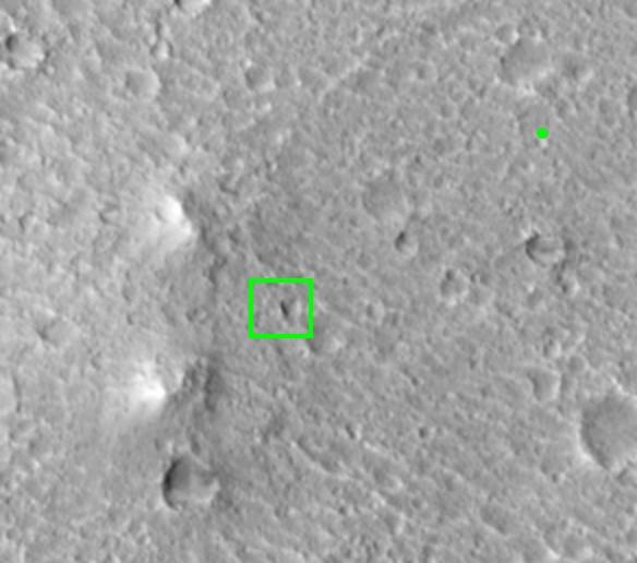
MRO Images Pathfinder Landing Site
 Earlier today, NASA released the first MRO images of the Mars Pathfinder landing site (19.5 degrees N by 33 degrees W). They show, among other things, the lander itself, some of the bigger rocks in the vicinity, and the surrounding area. The context images show many of the familiar features we have come to know and love around Pathfinder, like the Big Crater and the famous "Twin Peaks." Some of you may remember that several years ago I authored two articles on the Enterprise Mission web site concerning what appeared to be a distant (and artificial) object in the Pathfinder panoramas, apparently at the base of the Twin Peaks. I dubbed this object the "Pathfinder Sphinx." I was of course immediately attacked by the usual twits (like Mac Tonnies -- do we post anything he doesn't attack out of hand?) who claimed that the object should have been visible in images of the site taken by Mars Global Surveyor. They were of course wrong about that, but in any event I was hopeful that MRO images might resolve the issue. Today, we got an image that could in fact prove I'm right and Tonnies and his pals are wrong. In the new MRO image, a bright straight line, precisely where I claimed the "Sphinx" was located, is visible at the base of the Twin Peaks. It is casting a distinct shadow, and there is nothing else in the image that is anywhere near as straight or casting a similar shadow. Unfortunately, the context image that I am drawing from is nowhere near the maximum resolution of the MRO camera, which can see objects just a few inches across. Only a small enlargement of the Pathfinder lander itself was released in full resolution. The context shots are "high resolution jpegs" -- a laughable term in any event. So far, NASA has not released a full resolution version of the entire image strip, and it may not be easy to obtain one. But based on today's image and the anomalous nature and (perfect placement) of the shadowed object, I'm willing to bet it will show that we're right, and Tonnies is wrong. That makes it about: Enterprise 87 - Tonnies 0
|
|
|
|
|
Campos electromagnéticos torcidos es la especialidad de los físicos rusos:http://www.amasci.com/freenrg/tors/doc17.htmlMe llama mucho la atención al experimento hecho con pirámides en miniatura pues usando COBRE (el metal preferido de los antiguos) y procedimientos técnicos de Nikolai Tesla permite escapar a partir del ápice de la pirámide una energía en forma de DNA! Vean la foto:http://www.keelynet.com/unclass/hardy1.htmEn Egipto esto era llamado de Ben Ben o serpiente arco iris y en verdad el DNA parece el símbolo de la medicina usado desde antes de Hipócrates en Grecia: 2 serpientes cruzadas. El mismo símbolo usado por los mayas:http://fotolog.terra.com/detodounpoco:75Este hombre es el austriaco Antón Zeilenger:http://www.andyross.net/zeilinger.jpgÉl dobló fotones (luz) en forma de DNA múltiple.http://www.physics.gla.ac.uk/Optics/play/photonOAM/Hay muchos que especulan por qué la Gran Pirámide no tiene su piedra faltante o piramidión. Sospechan que pudo ser algo de cuarzo o un meteorito o de basalto cubierto con láminas de oro, cobre, aleación de metales, etc. Es probable que nunca tuviera ninguna piedra de ángulo coronándola. La masonería conoce bien esto y era parte del conocimiento de Tolkien quien escribió El Señor de los Anillos donde una torre poderosa tenía un OJO  omnipresente y poderoso. Esto nos vuelve a llamar la atención a la Gran Pirámide de Egipto que tuve ocasión de ver y equivale a un rascacielos de 45 pisos hecho de un tipo de granito especial.Christopher Dunn escribió un libro muy interesante con base científica y menos especulativa sugiriendo que la Gran Galería de la pirámide tenía 27 resonadores Helmholtz cuyas marcas son visibles hasta hoy (vean fotos y traduzcan el documento). Esto sugiere que todo el edificio fue hecho como una máquina pétrea generadora de poder nuclear que funcionaba con ultrasonido. Lo que demuestra que hubo una explosión nuclear dentro de la Gran Pirámide. Las paredes interiores fueron calcinadas.http://www.gizapower.com/Blast.htmEl físico ucraniano, Dr.Volodymyr Krasnoholovets comparte el entusiasmo de esta teoría y literalmente se saca el sombrero en base a las conclusiones de Dunn. Quien quiera escribirle -algunos de esos idiotas que me critican en el foro- puede anotar la dirección aquí:http://www.gizapower.com/updates.htmlSu website es éste:http://www.inerton.cjb.net/Y su e-mail es éste:krasnoh@iop.kiev.ua */ // -->Su especialidad es materia condensada e inertons. No es un “charlatán” amateur sino que tiene 20 años de experiencia en alta física que ni en sueños tendremos en Perú:http://www.gizapyramid.com/BIO-DrK.htmOtra versión del asunto es el uso de Fisión nuclear con plutonio. omnipresente y poderoso. Esto nos vuelve a llamar la atención a la Gran Pirámide de Egipto que tuve ocasión de ver y equivale a un rascacielos de 45 pisos hecho de un tipo de granito especial.Christopher Dunn escribió un libro muy interesante con base científica y menos especulativa sugiriendo que la Gran Galería de la pirámide tenía 27 resonadores Helmholtz cuyas marcas son visibles hasta hoy (vean fotos y traduzcan el documento). Esto sugiere que todo el edificio fue hecho como una máquina pétrea generadora de poder nuclear que funcionaba con ultrasonido. Lo que demuestra que hubo una explosión nuclear dentro de la Gran Pirámide. Las paredes interiores fueron calcinadas.http://www.gizapower.com/Blast.htmEl físico ucraniano, Dr.Volodymyr Krasnoholovets comparte el entusiasmo de esta teoría y literalmente se saca el sombrero en base a las conclusiones de Dunn. Quien quiera escribirle -algunos de esos idiotas que me critican en el foro- puede anotar la dirección aquí:http://www.gizapower.com/updates.htmlSu website es éste:http://www.inerton.cjb.net/Y su e-mail es éste:krasnoh@iop.kiev.ua */ // -->Su especialidad es materia condensada e inertons. No es un “charlatán” amateur sino que tiene 20 años de experiencia en alta física que ni en sueños tendremos en Perú:http://www.gizapyramid.com/BIO-DrK.htmOtra versión del asunto es el uso de Fisión nuclear con plutonio.  La Cámara del Rey contenía -según el autor- óxido de uranio además de otros ingredientes dentro del sarcófago de granito mucho más duro y denso que el resto del granito en esa Cámara que aparentemente estaba sellada para que entrase agua. Es importante mencionar QUE NUNCA SE HA ENCONTRADO ALGUNA MOMIA EN EL INTERIOR DE LAS PIRÁMIDES como acostumbran mentir. Las momias están en el Valle de los Reyes y se supone que fueron llevadas allá desde las pirámides pero no hay evidencia. El sarcófago no era más que un CENOTAFIO, una cámara ritual o de otros propósitos. Agua aparentemente pudo entrar por la Gran Galería. Durante siglos han estado robando partes encontradas y el gobierno egipcio realmente no muestra todo lo que encuentra “al vivo” como han documentado. Vale la pena imprimir y traducir lo siguiente:http://www.nuclearpyramid.com/great_pyramid.phphttp://www.nuclearpyramid.com/other_two_pyramids.phpEl problema, sin embargo, es que quien escribe en este caso sugiere que debe investigarse tal o cual cosa porque él mismo no debe haber tenido acceso como sí lo tuvo Chris Dunn mencionado más arriba.Habían 144.000 piedras externas que fueron removidas por los árabes y los registros indican que habían marcas de agua hasta la mitad de la pirámide. Fue en 1920 que el francés Antoine Boyis hizo un descubrimiento que, a pesar de la alta humedad y el calor en la cámara principal, los cuerpos de los animales muertos no se descomponían sino que estaban completamente deshidratados. Él fue el iniciador de hacer modelos a escala orientados en la misma dirección de la Gran Pirámide y colocó un gato muerto a aproximadamente el mismo nivel de la cámara principal. El resultado fue el mismo. Ya en la década de los 60 los investigadores de Checoslovaquia (notan que en esa región del globo son ellos siempre los pioneros y no los americanos?) hicieron estudios limitados con relación a la geometría y repitieron los experimentos con los mismos resultados. Resulta que el formato en sí permite preservar comidas, afilar hojas de afeitarse, inducir a la germinación de plantas y su crecimiento más veloz o sanar heridas de animales. Otros científicos creen que es el contenido de cuarzo (a propósito el silicio del computador es tomado de joyas) en los bloques de granito y la increíble presión a que tales bloques son sometidos que creen que tal cámara es el foco principal de campos piezoeléctricos. Las medidas del magnetómetro dentro de la cámara muestran altos niveles de un campo geomagnético. ¡Esto me llama la atención porque recordé que en Machu Picchu las piedras cargan pilas cerca al Intihuatana que “amarra el Sol” y que la aguja de las brújulas puede ser alterada. Resulta que la Gran Pirámide es la más pesada estructura en un solo punto que está al medio de los continentes!http://www.world-mysteries.com/mpl_2_ps.jpghttp://www.biblebelievers.org.au/images/pyr4.gifhttp://www.gizapyramid.com/Image34.gifEsto en un planeta que gira como un trompo sobre su propio eje y que quizás sea como un imán en su interior. Es como si los egipcios hubiesen hecho el monumento para servirse de la gravedad o el electromagnetismo. Un dínamo o máquina de piedra con facultad de usar poder nuclear. PERO NO COMO EN EL FILM STARGATE. Esto no es una pirámide-cohete:http://fotolog.terra.com.br/inca:39http://fotolog.terra.com.br/inca:40Esa película original tiene conceptos interesantes como el efecto especial acuoso que recuerda el extraño EFECTO CASIMIR LÍQUIDO conocido en física. También vemos que el Et que se transporta a la nave usa ANILLOS y ya hay físicos que creen que la Gran Pirámide pudo de alguna forma estar relacionado con ANILLOS TORO. http://fotolog.terra.com.br/inca:138Traduciendo: para mí ciertos fenómenos conocidos por las antiguas civilizaciones y actualmente la masonería y la NASA masónica funcionan en los “ombligos” electromagnéticos del mundo. En determinados días como eclipses, solsticios, equinoccios, etc., es posible que las estructuras del espacio-tiempo se abran si se construyen los megalitos de piedra –huesos de la Tierra- en esos puntos. ESA ES LA RAZÓN POR LA CUAL TODOS LOS MEGALITOS ANTIGUOS ESTÁN SEPARADOS MATEMÁTICAMENTE A INTERVALOS Y LATITUDES EXACTAS a pesar de que cada una de esas civilizaciones no co-existiese con otras necesariamente o siempre. Es como si el proyecto hubiese sido visto desde arriba (y desde adentro de la Tierra) por entidades hiperdimensionales que usaron las mentes de los hombres para sus fines. Vean el mapa de los megalitos en el mundo:http://fotolog.terra.com/detodounpoco:767Solo que en todos esos megalitos (excepto quizás la Gran Pirámide pero no sé) sangre fue derramada como holocausto a los dioses. No hay jeroglíficos de dioses hum-animales en la Gran Pirámide. Era como si el proyecto fuese literalmente llenar la Tierra de violencia y sabemos que las batallas acostumbran librarse en los mismos lugares por generaciones o que fenómenos paranormales acostumbran pasar donde homicidio o suicidio ya aconteció antes.Los masones de la NASA en el 97 enviaron el Pathfinder tetraédrico a aterrizar en Marte a la latitud 19.5 Norte y 33 Oeste mientras la Tierra estaba posicionada a 19.5 grados arriba del horizonte oriental marciano visto desde el Pathfinder. Por buenas razones ellos están OBSESIONADOS con las latitudes como 19.5 y 33. Saben por qué? Lo que voy a decirles ahora es un SECRETO EN EL PERÚ y deseo compartirlo con ustedes aunque me llamen de los nombres o adjetivos que gusten. Todas las esferas rotatorias con cuerpos líquidos permiten una CASCADA DE ENERGÍA HIPERDIMENSIONAL que simplemente hace aparecer “de la nada” formas geométricas. Es en la latitud 19.6 N que se encuentra el más grande volcán terrestre en Hawai, Mauna Kea; el fenómeno del Niño a 19.5 en Marte los mayores volcanes de la Vía Láctea están en Olympus Mons en latitud 19.3 N. La mancha roja de Júpiter está justamente en la latitud 19.5 Sur. Formas geométricas también aparecen en los polos de planetas así como hexágonos solares. Producción de nubes brillantes en Saturno en 1994 fueron en la latitud 19.5 grados N. El inmenso Mare Orientale de la Luna es en la misma latitud. Lo mismo es cierto en la gran mancha azul de Neptuno cerca de la latitud 19.5 y su gemelo Urano irradiando 3 veces + energía que la que reciben del Sol, etc. La pirámide del Sol en Teotihuacan además de los volcanes Iztaccihuatl y Popocatepetl en México están en la misma latitud. No es extraño que la NASA se ofrezca a ayudar a los arqueólogos mexicanos a encontrar ruinas mayas.Quien desee saber + sobre hiperfísica lea aquí:http://www.bibliotecapleyades.net/ciencia/ciencia_hyperphysics1.htmhttp://www.enterprisemission.com/hyper3.html¿La Tierra ha estado desacelerando en su movimiento alrededor de su eje?http://www.enterprisemission.com/images/hyper/time.gifCurioso porque se supone que se ha mantenido “estable” más o menos 1 segundo en un millón de años. Solo que literalmente para “ajustar” tuvieron que usar relojes atómicos ajustando más de 20 segundos en 20 años. En otras palabras hay un cambio entre la rotación de la Tierra y las constantes a nivel atómico que gobiernan el quantum Standard de los relojes. Un cambio en el momento angular de la Tierra. Simultáneamente LOS PROPIOS RELOJES SON ALTERADOS INTERNAMENTE. Una reestructura de la realidad hiperdimensional a cada 13.000 años:http://www.enterprisemission.com/hyper3.html La Cámara del Rey contenía -según el autor- óxido de uranio además de otros ingredientes dentro del sarcófago de granito mucho más duro y denso que el resto del granito en esa Cámara que aparentemente estaba sellada para que entrase agua. Es importante mencionar QUE NUNCA SE HA ENCONTRADO ALGUNA MOMIA EN EL INTERIOR DE LAS PIRÁMIDES como acostumbran mentir. Las momias están en el Valle de los Reyes y se supone que fueron llevadas allá desde las pirámides pero no hay evidencia. El sarcófago no era más que un CENOTAFIO, una cámara ritual o de otros propósitos. Agua aparentemente pudo entrar por la Gran Galería. Durante siglos han estado robando partes encontradas y el gobierno egipcio realmente no muestra todo lo que encuentra “al vivo” como han documentado. Vale la pena imprimir y traducir lo siguiente:http://www.nuclearpyramid.com/great_pyramid.phphttp://www.nuclearpyramid.com/other_two_pyramids.phpEl problema, sin embargo, es que quien escribe en este caso sugiere que debe investigarse tal o cual cosa porque él mismo no debe haber tenido acceso como sí lo tuvo Chris Dunn mencionado más arriba.Habían 144.000 piedras externas que fueron removidas por los árabes y los registros indican que habían marcas de agua hasta la mitad de la pirámide. Fue en 1920 que el francés Antoine Boyis hizo un descubrimiento que, a pesar de la alta humedad y el calor en la cámara principal, los cuerpos de los animales muertos no se descomponían sino que estaban completamente deshidratados. Él fue el iniciador de hacer modelos a escala orientados en la misma dirección de la Gran Pirámide y colocó un gato muerto a aproximadamente el mismo nivel de la cámara principal. El resultado fue el mismo. Ya en la década de los 60 los investigadores de Checoslovaquia (notan que en esa región del globo son ellos siempre los pioneros y no los americanos?) hicieron estudios limitados con relación a la geometría y repitieron los experimentos con los mismos resultados. Resulta que el formato en sí permite preservar comidas, afilar hojas de afeitarse, inducir a la germinación de plantas y su crecimiento más veloz o sanar heridas de animales. Otros científicos creen que es el contenido de cuarzo (a propósito el silicio del computador es tomado de joyas) en los bloques de granito y la increíble presión a que tales bloques son sometidos que creen que tal cámara es el foco principal de campos piezoeléctricos. Las medidas del magnetómetro dentro de la cámara muestran altos niveles de un campo geomagnético. ¡Esto me llama la atención porque recordé que en Machu Picchu las piedras cargan pilas cerca al Intihuatana que “amarra el Sol” y que la aguja de las brújulas puede ser alterada. Resulta que la Gran Pirámide es la más pesada estructura en un solo punto que está al medio de los continentes!http://www.world-mysteries.com/mpl_2_ps.jpghttp://www.biblebelievers.org.au/images/pyr4.gifhttp://www.gizapyramid.com/Image34.gifEsto en un planeta que gira como un trompo sobre su propio eje y que quizás sea como un imán en su interior. Es como si los egipcios hubiesen hecho el monumento para servirse de la gravedad o el electromagnetismo. Un dínamo o máquina de piedra con facultad de usar poder nuclear. PERO NO COMO EN EL FILM STARGATE. Esto no es una pirámide-cohete:http://fotolog.terra.com.br/inca:39http://fotolog.terra.com.br/inca:40Esa película original tiene conceptos interesantes como el efecto especial acuoso que recuerda el extraño EFECTO CASIMIR LÍQUIDO conocido en física. También vemos que el Et que se transporta a la nave usa ANILLOS y ya hay físicos que creen que la Gran Pirámide pudo de alguna forma estar relacionado con ANILLOS TORO. http://fotolog.terra.com.br/inca:138Traduciendo: para mí ciertos fenómenos conocidos por las antiguas civilizaciones y actualmente la masonería y la NASA masónica funcionan en los “ombligos” electromagnéticos del mundo. En determinados días como eclipses, solsticios, equinoccios, etc., es posible que las estructuras del espacio-tiempo se abran si se construyen los megalitos de piedra –huesos de la Tierra- en esos puntos. ESA ES LA RAZÓN POR LA CUAL TODOS LOS MEGALITOS ANTIGUOS ESTÁN SEPARADOS MATEMÁTICAMENTE A INTERVALOS Y LATITUDES EXACTAS a pesar de que cada una de esas civilizaciones no co-existiese con otras necesariamente o siempre. Es como si el proyecto hubiese sido visto desde arriba (y desde adentro de la Tierra) por entidades hiperdimensionales que usaron las mentes de los hombres para sus fines. Vean el mapa de los megalitos en el mundo:http://fotolog.terra.com/detodounpoco:767Solo que en todos esos megalitos (excepto quizás la Gran Pirámide pero no sé) sangre fue derramada como holocausto a los dioses. No hay jeroglíficos de dioses hum-animales en la Gran Pirámide. Era como si el proyecto fuese literalmente llenar la Tierra de violencia y sabemos que las batallas acostumbran librarse en los mismos lugares por generaciones o que fenómenos paranormales acostumbran pasar donde homicidio o suicidio ya aconteció antes.Los masones de la NASA en el 97 enviaron el Pathfinder tetraédrico a aterrizar en Marte a la latitud 19.5 Norte y 33 Oeste mientras la Tierra estaba posicionada a 19.5 grados arriba del horizonte oriental marciano visto desde el Pathfinder. Por buenas razones ellos están OBSESIONADOS con las latitudes como 19.5 y 33. Saben por qué? Lo que voy a decirles ahora es un SECRETO EN EL PERÚ y deseo compartirlo con ustedes aunque me llamen de los nombres o adjetivos que gusten. Todas las esferas rotatorias con cuerpos líquidos permiten una CASCADA DE ENERGÍA HIPERDIMENSIONAL que simplemente hace aparecer “de la nada” formas geométricas. Es en la latitud 19.6 N que se encuentra el más grande volcán terrestre en Hawai, Mauna Kea; el fenómeno del Niño a 19.5 en Marte los mayores volcanes de la Vía Láctea están en Olympus Mons en latitud 19.3 N. La mancha roja de Júpiter está justamente en la latitud 19.5 Sur. Formas geométricas también aparecen en los polos de planetas así como hexágonos solares. Producción de nubes brillantes en Saturno en 1994 fueron en la latitud 19.5 grados N. El inmenso Mare Orientale de la Luna es en la misma latitud. Lo mismo es cierto en la gran mancha azul de Neptuno cerca de la latitud 19.5 y su gemelo Urano irradiando 3 veces + energía que la que reciben del Sol, etc. La pirámide del Sol en Teotihuacan además de los volcanes Iztaccihuatl y Popocatepetl en México están en la misma latitud. No es extraño que la NASA se ofrezca a ayudar a los arqueólogos mexicanos a encontrar ruinas mayas.Quien desee saber + sobre hiperfísica lea aquí:http://www.bibliotecapleyades.net/ciencia/ciencia_hyperphysics1.htmhttp://www.enterprisemission.com/hyper3.html¿La Tierra ha estado desacelerando en su movimiento alrededor de su eje?http://www.enterprisemission.com/images/hyper/time.gifCurioso porque se supone que se ha mantenido “estable” más o menos 1 segundo en un millón de años. Solo que literalmente para “ajustar” tuvieron que usar relojes atómicos ajustando más de 20 segundos en 20 años. En otras palabras hay un cambio entre la rotación de la Tierra y las constantes a nivel atómico que gobiernan el quantum Standard de los relojes. Un cambio en el momento angular de la Tierra. Simultáneamente LOS PROPIOS RELOJES SON ALTERADOS INTERNAMENTE. Una reestructura de la realidad hiperdimensional a cada 13.000 años:http://www.enterprisemission.com/hyper3.html |
|
|
|
|
Sitio de Aterrizaje del Mars Pathfinder

En la imagen de arriba (el Norte está arriba), puede ver la región general de los sitios de aterrizaje del Viking 1 y el Pathfinder, ambos en Chryse Planitia.
Algunas características principales, como Amazonis Planitia, el Olympus Mons, Alba Patera, Uranius Tholus, Ceraunius Tholus, Fesenkov, Tharsis Tholus, los tres Tharsis Montes, Valles Marineris, Tempe Terra, Sharonov, Chryse Planitia, Xanthe Terra, Margaritifer Sinus, Acidalia Planitia, y el Ares Vallis, también están marcados.
Los tres Tharsis Montes son: Norte: Ascraeus Mons, Centro: Pavonis Mons, Sur: Arsia Mons
La imagen de arriba es parte de un mapa del Mars Atlas Web site. (en Inglés)
Las características en él, fueron marcadas por el Observatorio ARVAL.
Para otra buena fuente de mapas de Marte, enlace con el Planetary Data System's Mars Explorer. (en Inglés)
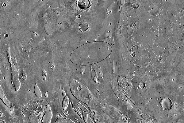
Un sitio de aterrizaje para el Mars Pathfinder ha sido escogido en 19.5 N, 32.8 W, en la Chryse Planitia, área del Ares Vallis, al Nor-Este del Valles Marineris.
El sitio se muestra arriba. La imagen muestra el área nominal de aterrizaje como un óvalo superpuesto sobre una imagen del Orbitador Viking. El blanco de aterrizaje está en el centro del óvalo de 200 Km por 70 Km.
La resolución aproximada de esta imagen es de 32 pixels por grado = 1,8 Kilómetros por pixel = 1 milla náutica por pixel.
El borde superior de la imagen está aproximadamente a 23 grados Norte.
El borde inferior de la imagen está aproximadamente a 15 grados Norte.
El tamaño de la imagen es de unos 460 Km (255 MN) desde el borde del Norte al borde del Sur.
El sitio real de aterrizaje fue en 19,33 N, 33,55 W, está marcado por una X en la imagen de arriba.
NASA ha seleccionado una antigua planicie de inundación en Marte como el sitio de aterrizaje de la misión Pathfinder. Hace ya eones, cuando el agua corría en Marte, hubo grandes inundaciones en el sitio de aterrizaje, localizado en una planicie rocosa de un área conocida hoy en día como Ares Vallis. El sitio está 850 Kilómetros (527 millas) al Sur-Este de la posición del Viking 1, que en 1976 fue la primera nave que aterrizó en Marte. El Pathfinder será el primero en aterrizar en Marte desde que los módulos de aterrizaje gemelos Viking llegaron hace casi 21 años. La nave, planificada para llegar el 4 de Julio de 1997, bajará en paracaídas en el Ares Vallis, en la boca de un antiguo canal de descarga, escogido por la variedad de rocas y muestras de suelo que puede presentar.
El Ares Vallis, que cumple con las restricciones de ingeniería, fue escogido luego de seminarios, al principio de este año, en los que participaron invitados de toda la comunidad científica involucrada con Marte. Asistieron más de 60 científicos de los Estados Unidos y Europa.
El sitio en el Ares Vallis es también un sitio ideal de recolección, según Golombeck, situado en la salida de un gran canal de descarga en el que una amplia variedad de rocas está potencialmente dentro del alcance del rover. Aún cuando los orígenes exactos de las muestras no serán conocidos, dijo, la oportunidad de hacer un muestreo de una variedad de rocas en un área pequeña podría revelar mucho sobre Marte. Las rocas habrían sido arrastradas desde las tierras altas en la época en que las inundaciones se movían sobre la superficie de Marte.
Varios sitios potenciales fueron listados, en donde antiguos canales de inundación se vaciaron en la Chryse Planitia, habiendo cortado a través de bloques de corteza y planicies aserradas, donde el agua pudo haber recogido materiales para depositarlos en la planicie. Todos los sitios fueron estudiados usando datos del orbitador Viking.
Actualizada: Julio 9 '97
Optimizada para ser vista con MS Internet Explorer.
Regreso a la página de la Misión Mars Pathfinder en ARVAL
Mensajes:
Comunicaciones
|
|
|
|
|
NASA and the Ancient Egypt Connection While reading the new book “Dark Mission” by Bara and Hoagland, I was amazed when I came to chapter 5 A Conspiracy Unfolds. The book delves into the aspect that NASA’s planners for mission times and locations were basing all of it on the Ancient Egyptian religion of Horus and Isis! It started when Hoagland looked closely at the NASA “Apollo” insignia and discovered the three stars of Orion’s Belt forming the horizontal line in the “A”, which as been accepted as representing “Apollo”. Here are just some of the discoveries he made using a program (Red Shift) that shows the location of the stars during major events in the “Apollo” program. a) The rest of the stars in the constellation of Orion were present on the patch. b) The “A” on the patch represents not Apollo, but Asar: the Greek name for Osiris. c) The “communion” that Aldrin preformed in the “Sea of Tranquility” was not done in the Christian tradition, but in the tradition of the Ancient Egyptian custom of paying homage to Osiris (upon study, Hoagland discovered that the communion rite originated in Ancient Egypt in honor of Osiris, and not by Christianity as it is accepted today). What’s more is that Armstrong flew the Lunar Module (Eagle), 5 miles further west from the intended landing site to get to the location of Tranquility to mark this as the Apollo 11 Landing Zone, risking the fuel supply claiming that it was too “rocky”. At the exact time and that the communion rite would be performed in this spot by Aldrin, Sirius (the Star of Isis) would be waiting, directly above the site at 19.5 degrees on the night of July 20th 1969 exactly 33 minutes after touchdown. Waiting 33 minutes after touchdown represents the highest level of Masonry: the 33rd degree. d) Upon further study of the alignment of the stars at the time and location of landing sites, as well as the names of the missions and the names of the missions and hardware used, such as “Falcon” and “Atlantis” and found unbelievable “hidden meaning” behind them ALL as well as the alignments of "sacred stars" during every single mission! e) Upon putting in all the coordinates for the time when the very first image was snapped of the “Face of Cydonia” on 7/25/1976, he was amazed to see that the star “Alnitak”, one of the stars of Orion’s Belt, was directly overhead! This implies that those who are really behind the NASA program knew it was there already! f) When Apollo 8 fired it’s rocket to descend into lunar orbit for the first time on 12/24/1968, “Mintaka”, another of Orion’s Belt was “dead on the horizon”. There are countless other alignments that were also discovered, too many to mention in fact. One worth mentioning though is the fact that Hoagland discovered that Masonry did not get it’s start in 1717 as is accepted today, but goes all the way back to Ancient Egypt. He also mentions that, because of the importance of dates and star location in the Ancient Egyptian way, he discovered the 10,500 B.C. dates of the Pyramids and Sphinx in Giza as well, based on the work of Hancock in “The Quest for Lost Civilizations” where Hancock was able to use precession to show that all major structures on Earth, including the “Spider” in Nazca aligning with the constellation “Scorpio” in 10,500 B.C. To me, this gives enormous credibility to the ancient text’s of Egypt as well as how seriously it is revered and followed by those who really run NASA behind the scenes. Hoagland also points out that the Ancient Egyptians, though relating their story to the stars, spoke to the fact that they did not see these deity’s as “representations” of the stars, but were living, breathing beings! Although I fully believe that the ancient Sumerians and Egyptians were right on, proven by their incredible knowledge of the Galactic time-lines and make-up, I am shocked to see this taken as serious by NASA "insiders"! http://www.abovetopsecret.com/forum/thread328501/pg1 |
|
|
|
|
"Path" es como sendero o camino, "finder" viene de encontrar, entonces yo diría que es algo como "explorador/descubridor de caminos/senderos" |
|
|
|
|
I think that would be an always changing number, not a constant. We're always moving around! On the Sun: sunspot activity and the region of peak temperatures is limited to 19.5 degreees north and south. On Venus: the presumably active major volcano complexes Alpha and Beta Regio are near 19.5 degrees. On Earth: Mauna Loa, Hawaii (19 degrees 28 minutes N, 155 degrees 37 minutes W) The largest shield volcano is at 19.6 degrees north. This is Mauna-Kea volcano on the island of Hawaii. Mexico City, Mexico (19 degrees 23 minutes N, 99 degrees 10 minutes W) The Pyramid of the Sun at Teotihuacan is at 19.6 degrees north. Dzibalchen, (Yucatan), Mexico (19 degrees 28 minutes N, 89 degrees 46 minutes W) Georgetown, Grand Cayman Island (19 degrees 18 minutes N, 81 degrees 26 minutes W) Mount Emi Koussi, Chad, Africa (19 degrees 47 minutes N, 18 degrees 34 minutes E) Mount Kalsubai, (near Bombay), India (19 degrees 33 minutes N, 73 degrees 43 minutes E) Mountain near Xiangkhoang, Laos (19 degrees 17 minutes N, 103 degrees 17 minutes E) Mountain near Potosi, Bolivia (19 degrees 13 minutes S, 66 degrees 22 minutes W) Yasur Volcano, Tanna Island, Vanuatu (South Pacific Ocean) (19 degrees 31 minutes S, 169 degrees 25 minutes E) Mount Samuel, Northwest Territory, Australia (19 degrees 13 minutes S, 134 degrees 8 minutes E) Gweru, Zimbabwe, Africa (19 degrees 31 minutes S, 29 degrees 49 minutes E) On Mars: the "vast" Olympus Mons shield cone volcano is at 19.5 degrees. On Jupiter: the "red spot" which is an obvious vortex is at 19.5 degrees. On Neptune: in 1986 Voyager II discovered a similar spot at 19.5 degrees north. Based on Richard Dannelley's book, Sedona: Beyond the Vortex and Bruce Rawles Why '19.5 degrees' is Significant 19.5 degrees is the angle that's been found by researchers (Richard C. Hoagland, Stanley McDaniel, Erol Torun, Horace W. Crater, etc.) to be repeatedly encoded in the structures of Cydonia. It is viewed as a definite 'signal in the noise' - some kind of a 'message' left there by some intelligence. 19.5 is called t, the 'tetrahedral constant', because of its significance in tetrahedral geometry (a tetrahedron is a pyramid shape composed of four equilateral triangular sides): the apexes of a tetrahedron when placed within a circumscribing sphere, one of the tetrahedron's apexes touching the north pole, the other three apexes touch the surface of the sphere at 19.5 degrees south latitude. Why this number would be important to the builders of the Martian structures is not clear (though Hoagland is theorizing that it has to do with what he calls "hyperdimensional physics"). Nile Time-Map & tetrahedral geometry -- 19.5 degrees http://prophetic.simplenet.com/elysium/nile-timemap.htm The emphasis on 19.5 degrees is not confined to the Martian structures. It has been found to be associated with various ancient structures here on earth - Giza pyramids, Avebury (the largest stone circle in the world, near Stonehenge), Pyramids of the Sun and Moon at Teotihuacan, etc. It is also worth noting that the Egyptian hieroglyph for Sirius, the brightest star in the sky which was extremely important to ancient Egyptians, is an equilateral triangle which can be viewed as a 2-dimensional representation of a tetrahedron; and in the Egyptian translation, it means a doorway... a sort of 'stargate'. Curiously, it has also been observed that 19.5 degrees is closely linked, for some reason, with the NASA space missions (for example, Mars Pathfinder landed at 19.5 degrees lat. of Mars on July 4, '97). In fact, not only did Pathfinder landed at 19.5 N, the longitude of the landing site was approximately 33 W - which is the very number of the longitude of the apex of the Great Bend of the Nile (33 E)! Now, this strongly insists on the relevance of the Nile numbers, and someone behind the scenes is well aware of it. As we move on, the number, 19.5, will also be very important in my Nile Time-map theory. Perhaps, as the Nile-Mars connection bridged by '19.5' appears to suggest, Mars was somehow involved during the 'Prometheus / Pandora period'. http://www.vortexmaps.com/planets.php
|
|
|
 Primer
Anterior
2 a 12 de 72
Següent
Primer
Anterior
2 a 12 de 72
Següent Darrer
|