This article is about the Mexican islands. For the Falkland island known as Isla María, see
Bleaker Island. For the Czech card game known as Mariáš which is similar to a German game, see
Sixty-Six (card game).
Islas Marías
 |
| Geography |
| Location |
Pacific Ocean |
| Coordinates |
 21°31′N 106°29′WCoordinates: 21°31′N 106°29′W 21°31′N 106°29′WCoordinates: 21°31′N 106°29′W |
| Archipelago |
Islas Marías |
| Total islands |
9 |
| Major islands |
María Madre, María Magdalena, María Cleofas & San Juanito |
| Area |
244.970 km2(94.583 sq mi) |
| Highest elevation |
616 m (2,021 ft) |
| Highest point |
Punta Rocallosa |
| Administration |
| Mexico |
| State |
Nayarit |
| Municipality |
San Blas, Nayarit |
| Largest settlement |
Puerto Balleto (pop. 602) |
| Demographics |
| Population |
1,116 (2005) |
| Pop. density |
7.68 /km2 (19.89 /sq mi) |
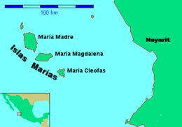
The Islas Marías ("Mary Islands") are an archipelago of four islands that belong to Mexico. They are located in the Pacific Ocean, some 100 km (62 mi) off the coast of the state of Nayarit and about 230 miles (370 km) southeast of the tip of Baja California.[1][2] They are part of the municipality (municipio) of San Blas, Nayarit. As of 2011, the islands are still being used as a penal colony, containing the Islas Marías Federal Prison.
The first European to discover the islands was Diego Hurtado de Mendoza, a cousin of Hernán Cortés in 1532, who gave them the name Islas Magdalenas. He found no evidence of prior habitation by the Native Americans.
In 2010 the archipelago was designated the Islas Marías Biosphere Reserve by UNESCO[3][4]
Geography[edit]
The islands have an aggregate area of 244.970 km². 1,116 people lived on Isla María Madre as of the census of 2005 along with around 8000 prisoners.[5] The other islands are uninhabited. The main settlement is Puerto Balleto, with a population of 602.
Isla María Madre is the largest of the islands, with a surface area of 145.282 km². It houses the Islas Marías Federal Prison which was established there in 1905. The next two largest islands are Isla María Magdalena (70.440 km²) and, further south, Isla María Cleofas (19.818 km²). They were named after three women called Mary in the Biblical New Testament: respectively, Mary, the mother of Jesus, Mary Magdalene, and Mary, the wife of Cleopas, and are referred to as the Tres Marias. A smaller island, San Juanito, with an area of 9.105 km² lies off the north coast of Isla María Madre.[6]
The islands are listed from north to south in the following table:
Geology[edit]
Research supports the hypothesis that the Islas Marias are fragments of continental crust left over from the separation of the Baja California Peninsula from the mainland of Mexico. Rocks found on the islands correspond with rocks found around Cabo San Lucas as well as Puerto Vallarta.[7]
Populated places[edit]
All populated places of the Islas Marías are on Isla María Madre. They are listed from north to south in the following table:
Each populated center features a different economic activity. The primary population center is Puerto Balleto, the location of the administrative offices and the primary centers of commerce and recreation. It is subdivided into four jefaturas[1]:
- Balleto, 21°38′02″N 106°32′21″W
- Bellavista, 21°38′19″N 106°32′30″W
- Unit Habitacional Miguel Hidalgo (UHMH), 21°38′13″N 106°32′26″W
- Primero de Mayo, 21°38′20″N 106°32′23″W
In addition to prisoners, on Maria Madre island there are employees of diverse institutions of the federal government, such as the Secretariat of Public Education, the Secretariat of the Environment, the Secretariat of Communications and Transport, post office, and the Secretariat of the Navy. Another group of settlers is made up of religious ministers and acolytes of the Catholic Church, nuns of the Order of Social Service, and invited teachers, technicians and their relatives.
The colony is governed by a state official who is both the governor of the islands and chief judge. The military command is independent and is exercised by an officer of the Mexican Navy.