|
|
ORIGEN DEL PATRON PLEYADES-ORION-SIRIO, EN EL MARCO A LA INDEPENDENCIA DE LOS ESTADOS UNIDOS, A LA MASONERIA, LA EGIPTOLOGIA, EL ISLAM, EL CATOLICISMO ESOTERICO, LA CIENCIA, EL SIONISMO, EL CAPITALISMO, CULTURA BABILONICA, SUMERIA, MAYA, ETC, ETC TIENE FUERTE RELACION CON LA CIUDAD DE JERUSALEN (LOBO, PERRO, CHACAL)-ULTRA SECRETO ESOTERICO DEL PORQUE DE LAS "RELACIONES CARNALES" ENTRE LOS ESTADOS UNIDOS CON EL SIONISMO
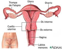
DAVINCI/DAVID
A/ESPADA/BLADE/SIMBOLO FALICO
V/CALIZ/CHALICE/RECIPIENTE/SIMBOLO FEMENINO
JERUSALEN/USA
JERUSALEN/JUAN/JVAN/33
HECHOS 12:12 (33)
JER/33
| milky way in Simple Gematria Equals: 119 |
( |
m 13 |
i9 |
l 12 |
k 11 |
y 25 |
0 |
w 23 |
a1 |
y 25 |
) |
| queen mary in Simple Gematria Equals: 119 |
( |
q 17 |
u 21 |
e5 |
e5 |
n 14 |
0 |
m 13 |
a1 |
r 18 |
y 25 |
|
| hebrew calendar in Simple Gematria Equals: 119 |
( |
h8 |
e5 |
b2 |
r 18 |
e5 |
w 23 |
0 |
c3 |
a1 |
l 12 |
e5 |
n 14 |
d4 |
a1 |
r 18 |
| mary magdalene in Simple Gematria Equals: 119 |
( |
m 13 |
a1 |
r 18 |
y 25 |
0 |
m 13 |
a1 |
g7 |
d4 |
a1 |
l 12 |
e5 |
n 14 |
e5 |
|
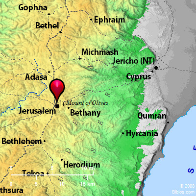
JERUSALEN ESTABA EN EL ANTIGUO TERRITORIO DE BENJAMIN/PERRO/LOBO/CHACAL
1. Génesis 49:27: Benjamín es LOBO arrebatador; A la mañana comerá la presa, Y a la tarde repartirá los despojos.
|
Apocalipsis 17:9. Para comprender esto, es necesario tener inteligencia y sutileza. Las siete cabezas son las siete colinas, sobre las cuales está sentada la mujer.
Veamos cuantas colinas tiene Jerusalén de los tiempos de Jesús y de San Juan Apóstol quien escribe estas palabras.

En la cultura oriental a la que pertenece San Juan, Jerusalén era conocida como “la ciudad de las siete colinas”. Esto lo confirma el texto histórico judío Pirke de-Rabbi Eliezer en la sección 10. Las siete colinas son Ophel, Sión, Moria, Besetha, Acra, Gareb y Goath. Recordemos que “siete” es el número de Dios en el lenguaje judío. Por eso allí la Ciudad para el Señor.
Si nos fijamos bien, podemos ver en esta ilustración algunas de las colinas. Se contempla Ophel, Moria y algo de Sión y Acra.


|
|
JOSUE 18
20. Y el Jordán era el límite al lado del oriente. Esta es la heredad de los hijos de Benjamín por sus límites alrededor, conforme a sus familias.
21. Las ciudades de la tribu de los hijos de Benjamín, por sus familias, fueron Jericó, Bet-hogla, el valle de Casis,
22. Bet-arabá, Zemaraim, Bet-el,
23. Avim, Pará, Ofra,
24. Quefar-haamoni, Ofni y Geba; doce ciudades con sus aldeas;
25. Gabaón, Ramá, Beerot,
26. Mizpa, Cafira, Mozah,
27. Requem, Irpeel, Tarala,
28. Zela, Elef, Jebús (que es Jerusalén), Gabaa y Quiriat; catorce ciudades con sus aldeas. Esta es la heredad de los hijos de Benjamín conforme a sus familias.
NUMERO 33 (RELACION CON EL PERIODO SIDEREO DE MERCURIO) / ESTRELLA DE DAVID / INTERRELACION CON ORION EN FUNCION AL AFELIO Y PERIHELIO DE MERCURIO
|
|
A gauche, l'emblème maçonnique.
A droite, l'"étoile de David".
Deux barres ou lignes horizontales appliquées sur le compas et l'équerre maçonniques suffisent à faire de l'emblème une étoile de David.
|
|
|
|
USA/UVA/VID/LINAJE
VA=ESTRELLA DE 6 PUNTAS=33=LL-AV-E DE D-AV-ID/D-AV-INCI
En aquel tiempo, respondiendo Jesús, dijo:
Te alabo, Padre, Señor del cielo y de la tierra,
que hayas escondido estas cosas (la Gnosis, la Sabiduría Oculta)
de los sabios (de los eruditos) y de los entendidos, (de los intelectuales)
y las hayas revelado á los niños. (A los Iniciados). Así, Padre, pues que así agradó en tus ojos."
(Mateo 11: 25-26). (El cielo y la tierra, es la alquimia, osea la ESCALERA DE JACOB. La cuadratura del circulo es el patron matematico de la alquimia y esta basado, insisto, en el numero de oro. Justamente Salomon es un tipo del GRIAL.)
"¡Oh profundidad de las riquezas de la sabiduría (sophia)
y de la ciencia (gnwsiV, gnosis) de Dios!
¡Cuán incomprensibles son sus juicios, e inescrutables sus caminos!"
(Romanos, 11: 33). (Camino es una referencia a MERCURIO y Juicio es una referencia a ORION=ESPADA. EL NUMERO 33 NO ESTA POR CASUALIDAD. ES UNA REFERENCIA A LA ESTRELLA DE 6 PUNTAS. OSEA QUE EN LA MISMA PALABRA ESTA CODIFICADA LA RELACION ORION-MERCURIO-VIA LACTEA. PENSAR QUE HAY IGNORANTES QUE DICEN QUE LOS ESCRITORES DE LA BIBLIA NO CONOCIAN EL PI. ESA ES LA SOBERBIA DEL SER HUMANO QUE SE CREE TENER MAS DERECHOS QUE EL CREADOR. ASI ESTA EL MUNDO. SOLO EN JESUCRISTO ESTA LA VERDADERA LIBERACION DE LA EGOLATRIA, IDOLATRIA Y DEL PECADO.)
BENJAMIN/PERRO/
LOBO/CHACAL
|
|
|
|
|
|
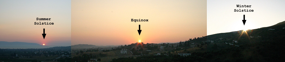
Why March 21st?
Bookmark or cite this page as <http://www.sym454.org/mar21/>
by Dr. Irv Bromberg, University of Toronto, Canada 
[Click here to go back to the Symmetry454 / Kalendis home page]
Churches take March 21st as the Ecclesiastical Vernal Equinox in calculating the date of Easter. This page takes an astronomical look at the equinox and March 21st.
The astronomical March equinox (northward equinox, spring equinox for the northern hemisphere) corresponds to the moment when Sun is at 0° ecliptic longitude, at which point the ecliptic intersects the celestial equator.
Even for ancient astronomers the observation of the approximate day of the equinox would have been easy — an appropriate fixed structure is all that is required to assess the solar altitude at local apparent noon, or a structure oriented in an east-west direction for assessing the proximity of sunrise to due east or the proximity of sunset to due west.
In the days of the Roman Empire, the word "equinox" had the literal Latin meaning "equal night", because the duration of daytime and night time are approximately equal on the date of an equinox. Due to atmospheric refraction, however, when Sun is near either horizon it always appears to be at a higher apparent altitude than its true geocentric position, so daytime at an astronomical equinox is always longer than night time.
For example, on the date of the March 2005 equinox in Jerusalem, the duration of the night was 11 hours and 44 minutes, whereas the duration of the day was 12 hours and 16 minutes, so that day was 32 minutes longer than the night. The actual date of equal day and night was March 12th, or 8 days before the astronomical March equinox. On the date of the astronomical September 2005 equinox in Jerusalem the duration of the day was 12 hours and 17 minutes, whereas the duration of the night was 11 hours and 42 minutes (this doesn't add up to exactly 24 hours because the seconds were rounded as they are insignificant and because it is already changing for the next day). That day was 35 minutes longer than the night. The actual date of equal day and night in Jerusalem in the autumn of 2005 was October 1st, or 8 days after the astronomical September equinox (southward equinox, autumnal equinox for the northern hemisphere).
The number of days that separate the equinoxes from the date of equal daytime and night time varies with latitude, with the least separation at higher latitudes where the length of the day changes more rapidly in the vicinity of the equinoxes. For example, in Toronto the equal day and night occurs about 5 days before the March equinox and 4–5 days after the September equinox. Saying that the day and night are equal is the same as saying that the daytime temporal hour, calculated as (sunset – sunrise) / 12, is exactly 60 minutes.
Click here to see charts of the variation of daytime length with latitude at the equinoxes and solstices  42KB. 42KB.
Click here to see charts of the variation of daytime length with latitude throughout the year 133KB. This chart shows that in both the north and south hemisphere the dates of equal length daytime and nightime (where the daytime lengths cross the 12-hour line) are several days prior to the spring equinox and several days after the autumn equinox. The gaps separating the 12-hour days from the equinoxes are unequal and differ between hemispheres, because of differences in Earth's orbital velocity, and are shorter at higher latitudes (further away from the equator), because the length of day changes more rapidly near the equinoxes at latitudes further away from the equator, as shown in the chart.
It is patently absurd to propose that the Church selected March 21st as the date of equal duration of day and night, because that introduces a discrepancy of more than a week regardless of whether one is speaking of Jerusalem, Alexandria, Vatican City, Nicaea or nearby Constantinople (today known as Istanbul).
The Babylonian Talmud (tractate Eruvin, page 56a) defined the equinox as the day on which Sun rises from the true east direction and sets to the true west direction (these are not the same as the directions shown by a magnetic compass, because the magnetic poles wander relative to the global axial poles). In modern astronomical terminology we would describe that as the day when the sunrise azimuth is 90° east of north or when the sunset azimuth is 90° west of north. True east was defined in Eruvin as the horizon mid-point between the furthest north-east sunrise on the day of the north solstice (summer solstice for the northern hemisphere) and the furthest south-east sunrise on the day of the south solstice (winter solstice for the northern hemisphere). True west was defined in Eruvin as the horizon mid-point between the furthest north-west sunset on the day of the north solstice and the furthest south-west sunset on the day of the south solstice. This definition is astronomically valid for all inhabited non-polar locales on planet Earth, but only within plus or minus a day or so because Sun rises exactly from true east only when the equinox moment occurs at sunrise for the observer's locale, and Sun sets exactly to true west only when the equinox moment occurs at sunset for the observer's locale, and because of errors due to the elevation of the locale as well as variations in atmospheric light refraction at the horizons.
Click here to see charts of the variation of the direction of sunrise and sunset with latitude at the equinoxes and solstices 42KB.
Rather than requiring the sunrise to be exactly from true east or sunset exactly to true west, which is unlikely unless an equinox moment occurs exactly at sunrise or sunset for that locale, one could define the northward equinox as the first day when the sunrise azimuth is less than 90° east of north, or as the first day when the sunset azimuth is less than 90° west of north, at some specified location.
The Hebrew calendar always begins calendar days at sunset, therefore the sunset azimuth is of observationally greater interest than the sunrise azimuth. Very possibly the early Christians, having had their origins in Judaism, also regarded days as starting at sunset. The modern practise of regarding civil time as starting at mean solar midnight is a relatively recent innovation, since the invention of mechanical clocks.
It is said that March 21st was selected as the ecclesiastical vernal equinox because the Church of Alexandria, whose staff were reputed to have astronomical expertise, reckoned that March 21st was the date of the equinox in 325 AD, the year of the First Council of Nicaea. The actual equinox moment that year occurred on Julian March 20th near local apparent noon in Alexandria. If the early Christians did regard days as starting at sunset then that equinox was 3/4 of the way through March 20th. More significantly, the selection of March 21st was sensible if the equinox was determined on the basis of the sunset azimuth. Taking 0° as true west, negative degrees as south of west, and positive degrees as north of west, I calculated the following sunset azimuths for March in 325 AD for the locale of Alexandria, Egypt:
Julian
Date in
325 AD | Proleptic
Gregorian
Date | Solar Position at Local Apparent Noon in Alexandria | Sunset Azimuth
at Alexandria
(0°=True West) |
| Solar Longitude | Solar Declination |
| March 18 |
March 19 |
358° 3' 2" |
– (0° 46' 55") |
– 0.8° |
| March 19 |
March 20 |
359° 1' 38" |
– (0° 23' 25") |
– 0.3° (last sunset of winter) |
| March 20 |
March 21 |
0° 0' 15"
(northward equinox moment near noon) |
0° 0' 6" |
+ 0.1° (first sunset of spring) |
| March 21 |
March 22 |
0° 58' 47" |
0° 23' 35" |
+ 0.6° |
| March 22 |
March 23 |
1° 57' 20" |
0° 47' 4" |
+ 1.0° |
Many religious as well as secular and even scientific sources regard the equinoxes and solstices as marking the beginning of the seasons, but astronomically, in terms of the insolation of solar energy, they actually mark the middle of their respective seasons (the Chinese got this right for the major solar terms of their traditional lunisolar calendar). Surface temperatures depend on the balance between solar insolation and the passive radiation of energy from Earth into space. During winter, radiative losses are increased by reflection from cloud cover and from surface snow and ice. In Rome, surface weather seasons lag behind their corresponding astronomical seasons by about 3+1/2 weeks. The astronomical spring season begins 1/2 season or about 6+1/2 weeks before the spring equinox. Thus the spring weather season begins (6+1/2) – (3+1/2) = about 3 weeks before the spring equinox, which is the beginning of the month of March. Arranging the calendar so that the spring equinox lands on March 21st causes the entire month of March to fall within the spring weather season in Rome. Could it be that the historical "theft" of a day and later another day from February was actually an early attempt to compensate for the equinox drifting earlier in March on the Julian calendar?
To compute the alignment of the astronomical March equinox on the Julian and Gregorian calendars, and to prepare the collection of charts offered in the table below, I used the calendrical calculation functions and astronomical algorithms described in "Calendrical Calculations" by Nachum Dershowitz and Edward M. Reingold, third edition published in 2008 by Cambridge University Press. I also employed some algorithms from "Astronomical Algorithms" by Jean Meeus, second edition, published in 1998 by Willmann-Bell, Richmond, Virginia, USA. Since neither of these books details the arithmetic for the revised Julian calendar, I used my own implementation (thanks to crucial help from Robert Harry van Gent of The Netherlands).
For each chart you may click on the thumbnail image to view it as a PNG (Portable Network Graphics image) your web browser, or click on the PDF icon to view a higher-quality image of the chart using a PDF reader such as the freely available Adobe Acrobat Reader. The PDF files are larger because they include a second page that covers a much longer term (to year 2800 AD for Julian, and to year 8500 AD for the Gregorian and revised Julian calendars).
On the following charts each astronomical March equinox moment is expressed in Universal Time (UT, the meridian of Greenwich, England). To convert UT to the mean solar time of Alexandria, Egypt (about 30° E) add 2 hours to the UT moment. For the mean solar time of Jerusalem, Israel (about 35° E) add 2 hours and 21 minutes to the UT equinox moment. For the mean solar time of Washington DC (77° W, the American Prime Meridian) subtract 5 hours and 8 minutes from the UT equinox moment.
| # | PNG Image | PDF | Description and Comments |
| 1. |

42KB
|

160KB
|
The moments of the March equinox on the Julian calendar for the years 1 to 400 AD (in the PDF up to 2800 AD).
For most of the 4th century and certainly from around the year of the Council of Nicaea in 325 AD and thereafter the equinox moment landed on March 20th. This graph is plotted in Universal Time for the Prime Meridian. If it were in terms of Alexandria mean solar time then the points would be 2 hours later. If the early Christians regarded days as starting at sunset then the points would be another 5+3/4 hours later, because sunset in Alexandria around the time of the equinox is about 5+3/4 hours before midnight. That would place about half of the equinox moments of the decade prior to 325 AD on March 21st.
The mean year of the Julian calendar is 365+1/4 days = 365 days and 6 hours, or approximately 11 minutes per year longer than the present-day northward equinoctial year. Soon after 325 AD the equinox landed no later than March 20th and has advanced earlier on the Julian calendar ever since. During the present century, shown on the second page of the PDF, most of the equinox moments will land on March 7th.
Note that in the first year after the Julian calendar epoch the equinox was on March 23rd.
|
| 2. |

42KB
|
255KB
|
The moments of the March equinox on the Gregorian calendar for the years 1583 to 2400 AD (in the PDF up to 8500 AD).
The graphically depicted "jitter" range of the Gregorian leap cycle, relative to the mean northward equinox, spans 2.1975 = 2 + 79/400 days. The jitter range of a smoothly spread 400-year leap day cycle would be 399/400 of a day, so the excess equinox jitter due to the unsmooth spread of Gregorian leap years amounts to 1.2 = 1 + 1/5 days.
For most of this time, with the exception of about half of the equinoxes of the 20th century, the equinox moment lands on March 20th. The chart suggests that March 21st was selected as the first day after the equinox, or, as Protestants since John Dee have asserted, that a 10-day correction was applied to the Julian calendar when actually an 11-day correction was required. The mean year of the Gregorian calendar, 365+97/400 days, is slightly too long, so in future millennia the equinox will drift to earlier dates.
The accuracy of the Gregorian calendar mean year was limited by the sexigesimal numeric notation that was used in the era of the Gregorian reform. The mean spring equinoctial year was expressed to the nearest 1/3600 of a day as 365+14/60+33/3600 days ≡ 365+97/400 days, which is exactly 3/400 ≡ 27/3600 of a day shorter than the Julian calendar mean year. Each 1/3600 of a day is 24 seconds. Deducting a further 1/3600 of a day yields the mean year of the Revised Julian calendar, discussed in the last row, below.
The future accelerated drift of the equinox towards earlier dates in March will commence when Earth's orbital perihelion appoaches the March Equinox, as explained on my web page: "The Lengths of the Seasons".
By constraining the equinox to land on March 21st, the Gregorian Reform implicitly shifted the epoch of the proleptic Gregorian calendar two days later than the Julian calendar, as it was pointed out above that in the first year after the Julian calendar epoch the equinox was on March 23rd.
The proleptic Gregorian calendar dates were the same as the Julian calendar from March 1st, 200 AD until February 28th, 300 AD. The years 200 and 300 AD were Julian leap years but not Gregorian leap years. As a consequence, as tabulated above, in 325 AD the northward equinox in Alexandria (or Jerusalem, whose mean solar time is only 21m 4s ahead) landed within a few minutes of noon on March 21st of the proleptic Gregorian calendar.
|
| 3. |

507KB
|
100KB
|
The moments of the March equinox on the Dee calendar for the years 1600 to 3600 AD, reckoned for the meridian of 77°W longitude = Washington, DC, which John Dee called "God's Longitude".
With a leap cycle of 33 years and 8 leap days per cycle the Dee calendar mean year is 365+8/33 days = 365 days 5 hours 49 minutes 5+5/11 seconds = 365.24... days.
Having a shorter mean year than the Gregorian calendar, and an epoch that was one day earlier, the equinox landed exactly on March 21st in the 17th century, when reckoned for 77°W longitude (an American "Prime Meridian").
The medium-term equinox "jitter" range is substantially less than the Gregorian calendar, in fact it equals the minimum that is possible for a leap day calendar, because the leap years of the Dee calendar are inherently distributed at intervals that are as smoothly spread as possible (seven 4-year intervals and one 5-year interval per 33-year cycle).
The future equinox drift rate of the Dee calendar will be less than half that of the Gregorian calendar.
|
| 4. |

33KB
|
262KB
|
The moments of the March equinox on the Revised Julian calendar (otherwise known as the "New Orthodox Calendar") for the years 1900 to 2400 AD (in the PDF up to 8500 AD).
The graphically depicted "jitter" range of the Revised Julian leap cycle, relative to the mean northward equinox, spans 2.362... = 2 + 163/450 days. The jitter range of a smoothly spread 450-year leap day cycle would be 449/450 of a day, so the excess equinox jitter due to the unsmooth spread of Revised Julian leap years amounts to 1.364... = 1 + 82/225 days.
For most of this time the equinox moment, in terms of Universal Time at the Prime Meridian, will land on March 20th. Again, it is highly improbable that the group of astronomers and mathematicians who recommended this calendar reform to the All-Orthodox Conference of 1923 in Constantinople, lead by the great Serbian astronomer, Milutin Milankovitch, could have erred significantly in predicting the date of the equinox, so it seems as if March 21st was selected as the first day after the equinox, or they simply forced their calendar reform to agree with the Gregorian calendar in the 20th century. The mean year of the revised Julian calendar, 365+109/450 days, is slightly too short, but as a consequence of the future shortening of the astronomical northward equinoctial year the revised Julian calendar will retain relatively good equinox alignment to beyond the year 8000 AD.
The future accelerated drift of the equinox towards earlier dates in March will commence when Earth's orbital perihelion appoaches the March equinox, as explained on my web page: "The Lengths of the Seasons".
By constraining the equinox to land on March 21st, the Orthodox Churches made the revised Julian calendar match the Gregorian calendar in the 20th century, implicitly shifting the proleptic revised Julian calendar epoch two days later than the Julian calendar epoch. The Gregorian and revised Julian calendars will have identical dates until March 1st, 2800 (because 2800 will be a Gregorian leap year but will not be a revised Julian leap year).
|
In non-leap years on the Julian, Gregorian, and revised Julian calendars, March 21st is day number 80, counting January 1 as day number 1, so 79 days elapse prior to March 21st. In leap years March 21st is day number 81, with 80 prior days elapsed. In the present era the March equinox on the Gregorian and revised Julian calendars, referred to Universal Time at the Prime Meridian, lands on the 79th day.
http://individual.utoronto.ca/kalendis/mar21.htm |
|
|
|
|
Earth's most recent solstice, the moment when the South Pole was closest to the Sun, was at 17:47 UT on 21 December 2009. Using Starry Night, the date of the solstice two thousand years ago appears to be 23 December, two days later.
Azimuth of the Sun at Sunrise:
Jerusalem 1 AD
21 December - 117° 36.763'
22 December - 117° 37.524'
23 December - 117° 37.695'
24 December - 117° 37.337'
25 December - 117° 36.381'
Why has the solstice date changed by two days over the last two thousand years?
Has the change of solstice date been a steady astrophysical drift or is it a calendrical artifact?
In addition to the switch from Julian to Gregorian calendar (which might not matter---I'd assume Starry Night uses Gregorian all the way, right?) there's precession and nutation. If the earth were likened to a spinning top, the slow wobble of the axis, rotating in the opposite direction of the spin, is precession. If you were to bump the spinning top, the axis would in addition, bob up and down as it makes the slow precession circle, and that's called nutation. The principles of physics for the top and Earth are similar.
But Precession is the primary cause of the slow drift of the equinoxes and solstices. The nutation is a smaller effect. |
|
|
|
|
The three stars do not line up at sunrise, but the night before (24 December), giving people and worshippers the direction where the next morning the sun will rise again. You can se this with any astronomical simulation software. The following are two shots of the simulated sky: one of the night of 24 and the other the morning of 25, in Jerusalem in the year 1 AD (the year when Jesus was supposedly born). Both the night of the 24 december and the sunrise of 25 december are shown from the same position and looking at the same azimuth.  High resolution version (click to enlarge):  In the Age of Aries (2000 BC), at the time of Horus, it was the same: This is the result for 2000 BC (when the winter solstice was january 6):  Hires version:  Quote:
What has me intrigued however is the concept that the Christ died for 3 days and then rises from the dead is indeed the static position of the sun on the 22nd of dec and sits there for 3 days before rising again
-where does thi knowledge come from ?
This too can be seen with any astronomical software. It was the most renowed characteristic of the sun path. Matthew 12:40 - "For just as JONAH WAS THREE DAYS AND THREE NIGHTS IN THE BELLY OF THE SEA MONSTER, so will the Son of Man be three days and three nights in the heart of the earth." The word "solstice" derive from the days of sun standstill at the Winter Solstice (Christmas). Its root is from latin: sōlstitium, equiv. to sōl, sun, + -stitium, from latin: sistere, to make stand. Here are the calculations made with SNPro, both in Jerusalem and Rome, that shows the standstill of the sun at the bottom is really 3 days (note: the last 3 digits were too small to be noticed with the naked eye, so the sun appears to completely stop moving in the sky): Azimuth of the Sun at Sunrise: Jerusalem 1 AD 15 December - 117° 19.938' 16 December - 117° 24.218' 17 December - 117° 27.837' 18 December - 117° 30.927' 19 December - 117° 33.390' 20 December - 117° 35.388' 21 December - 117° 36.763' 22 December - 117° 37.524'
23 December - 117° 37.695'
24 December - 117° 37.337' 25 December - 117° 36.381' 26 December - 117° 34.826' 27 December - 117° 32.676' 28 December - 117° 29.997' Rome 1 AD 15 December - 121° 26.891' 16 December - 121° 31.950' 17 December - 121° 36.252' 18 December - 121° 39.870' 19 December - 121° 42.727' 20 December - 121° 44.997' 21 December - 121° 46.585' 22 December - 121° 47.415'
23 December - 121° 47.564'
24 December - 121° 47.122' 25 December - 121° 45.909' 26 December - 121° 44.024' 27 December - 121° 41.380' 28 December - 121° 38.139' In the Age of Aries: Jerusalem 2000 BC 1 January - 117° 48.932' 2 January - 117° 51.190' 3 January - 117° 52.859' 4 January - 117° 54.004'
5 January - 117° 54.554'
6 January - 117° 54.577' 7 January - 117° 53.940' 8 January - 117° 52.776' 9 January - 117° 51.097' 10 January - 117° 48.762' 11 January - 117° 45.896' Calculations made with Starry Night Pro Plus v.6.2.3 http://freethoughtnation.com/forums/viewtopic.php?p=16312 |
|
|
|
|
The astral body position on the celestial sphere
The two coordinate systems
The following article recalls basic calculations to determinate the astral object position on the celestial sphere. These elements allow particularly to evaluate the solstitial rectangle dimensions, a rectangle joining Sunrise and Sunset positions at solstices and playing a key role within traditions facing East such as Celtic, Biblical, Roman and Christian ones.
According to the description of the celestial sphere, the observer position on Earth is determined by the latitude φ (phi). He may identify the position of stars and other astral objects on the celestial sphere by two coordinate systems, related either to the horizon or to the equator:
Horizontal coordinates
Altitude h: Angular distance above the horizon:
0 ≤ h ≤ 90°
Azimuth a: Angular distance measured along the horizon, eastwards from the south point:
0 ≤ a < 360°
Equatorial coordinates
Declination δ (delta): Angular distance measured along the star meridian, north or south the equator:
0 ≤ δ ≤ 90°, north the equator;
- 90° ≤ δ < 0, south the equator.
Hour angle τ (tau): Angular distance measured along the equator, from the observer to the star meridian:
0 ≤ τ < 360°
The change from one system to the other
The conversion of horizontal coordinates into equatorial coordinates and conversely can be derived from the properties of the spherical triangle ZNS delimited by the Zenith, the North Pole and the Star.
The angles and sides of that spherical triangle, measured respectively on the surface and from the centre of the celestial sphere, are the following:
- ang S= ?; ZN = 90°-φ
- ang Z= 180°-a; NS = 90°-δ
- ang N = τ; ZS = 90°-h
From spherical geometry, we get the three following main formulas:
- sin(ang Z)×sin(ZS) = sin(ang N)×sin(NS)
- sin(180°-a)×sin(90°-h)=sin(τ)×sin(90°-δ)
- sin(a)×cos(h) = sin(τ)×cos(δ)
- cos(ZS) = cos(ZN)×cos(NS)+sin(ZN)×sin(NS)×cos(ang N)
- cos(90°-h) = cos(90°φ)×cos(90°-δ)+sin(90°-φ)×sin(90°-δ)×cos(τ)
- sin(h) = sin(φ)×sin(δ)+cos(φ)×cos(δ)×cos(τ)
- cos(NS) = cos(ZN)×cos(ZS)+sin(ZN)×sin(ZS)×cos(ang Z)
- cos(90°- δ) = cos(90°-φ)×cos(90°-h)+sin(90°-φ)×sin(90°-h)×cos(180°-a)
- sin(δ) = sin(φ)×sin(h)-cos(φ)×cos(h)×cos(a)
These three formulas allow us to express a and h in terms of δ and τ and conversely. They will be useful to determinate the apparent Sun position at rising and setting time as well as at its zenith. Let us recall that the ecliptic plan, run by the Sun during its apparent move around the Earth, is titled by an angle of 23.5° with respect to the equator plan. It follows that the Sun declination varies from -23.5° to 23.5° (for more details, see the description of the celestial sphere).
Solstice Sunrise and Sunset azimuth
At Sunrise or Sunset, h = 0, and the last formula has the simple form:
- sin(δ) = - cos(φ)×cos(a)
- cos(a) = - sin(δ)/cos(φ)
Considering particularly the solstice and equinox Sun positions, we get the following results:
 - - At summer solstice, δ = 23.5° and
- cos(a) = - sin(23.5°)/cos(φ)
- - At winter solstice, δ = - 23.5° and
- cos(a) = sin(23.5°)/cos(φ)
- - At spring equinox, δ = 0 and
- a = 90°
- - At autumn equinox,δ = 0 and
- a = 270°
The above picture depicts the “solstitial rectangle” for Jerusalem located at latitude φ = 31.8°.
The “solstitial rectangle” is a square if a = 45° and cos(φ) = sin(23.5°)/cos(45°), that means at the latitude φ = 55.7° corresponding, for instance, to the Northern tip of Ireland.
High Sun altitude
The Sun occupies its highest position in the sky when it goes through the meridian of the observation place (at noon, solar time), i.e. when a = τ = 0 or 180°.
Let us consider the second formula with τ = 0:
- sin(h) = sin(φ)×sin(δ) + cos(φ)×cos(δ)
- sin(h) = cos(φ-δ) = sin[90°±(φ - δ)]
- h = 90°±(φ - δ)
As h ≤ 90°, we obtain the following formula:
- h = 90°-φ+δ, if φ > δ
- h = 90°+φ-δ, if φ ≤ δ
Consequently, the Sun can only reach the zenith (h = 90°) within the latitude band limited by the Cancer (φ = 23.5°) and Capricorn (φ = -23,5°) tropics. Then, the astral body declination must equal the latitude of the observation place. Such an event can, in particular, be observed in the Mesoamerica regions, formerly inhabited by the Mayas.
In the more general case, where δ may also be different from φ, let us consider the solstice and equinox Sun positions:
- - At summer solstice, δ = 23.5° and
- h = 113.5°-φ, if φ > δ
- h = 66.5°+φ, if φ ≤ δ
- - At winter solstice, δ = -23.5° and
- h = 66.5°-φ, if φ > δ
- h = 113.5°+φ, if φ ≤ δ
- - At equinoxes, δ = 0 and
- h = 90°-φ, if φ > δ
- h = 90°+φ, if φ ≤ δ
 The following picture gives the altitude results for Jerusalem located at latitude φ = 31.8°. The following picture gives the altitude results for Jerusalem located at latitude φ = 31.8°.
The Sun does not rise at all at winter solstice (h = 0) when the latitude equals (or exceeds) 66.5°, which corresponds to the Arctic Circle and, for instance, the Northern tip of Iceland.
A similar reasoning with τ = 180° would lead to comparable results.
http://users.skynet.be/lotus/column/elem-en.htm
|
|
|
|
|
◄ Benjamin Gate (Jerusalem) ►
|
Atlas
Benjamin Gate (Jerusalem) and surrounding area
Maps Created using Biblemapper 3.0
Additional data from OpenBible.info
You are free to use up to 50 Biblos coprighted maps (small or large) for your website or presentation. Please credit Biblos.com.
Occurrences
Jeremiah 20:2 Then Pashhur struck Jeremiah the prophet, and put him in the stocks that were in the upper gate of Benjamin, which was in the house of Yahweh.
Jeremiah 37:13 When he was in the gate of Benjamin, a captain of the guard was there, whose name was Irijah, the son of Shelemiah, the son of Hananiah; and he laid hold on Jeremiah the prophet, saying, You are falling away to the Chaldeans.
Jeremiah 38:7 Now when Ebedmelech the Ethiopian, a eunuch, who was in the king's house, heard that they had put Jeremiah in the dungeon (the king then sitting in the gate of Benjamin),
Encyclopedia
JERUSALEM
je-roo'-sa-lem:
I. THE NAME
1. In Cuneiform
2. In Hebrew
3. In Greek and Latin
4. The Meaning of Jerusalem
5. Other Names
II. GEOLOGY, CLIMATE AND SPRINGS
1. Geology
2. Climate and Rainfall
3. The Natural Springs
III. THE NATURAL SITE
1. The Mountains Around
2. The Valleys
3. The Hills
IV. GENERAL TOPOGRAPHY OF JERUSALEM
1. Description of Josephus
2. Summary of the Names of the Five Hills
3. The Akra
4. The Lower City
5. City of David and Zion
V. EXCAVATIONS AND ANTIQUITIES
1. Robinson
2. Wilson, and the Palestine Exploration Fund (1865)
3. Warren and Conder
4. Maudslay
5. Schick
6. Clermont-Ganneau
7. Bliss and Dickie
8. Jerusalem Archaeological Societies
VI. THE CITY'S WALLS AND GATES
1. The Existing Walls
2. Wilson's Theory
3. The Existing Gates
4. Buried Remains of Earlier Walls
5. The Great Dam of the Tyropoeon
6. Ruins of Ancient Gates
7. Josephus' Description of the Walls
8. First Wall
9. Second Wall
10. Third Wall
11. Date of Second Wall
12. Nehemiah's Account of the Walls
13. Valley Gate
14. Dung Gate
15. Fountain Gate
16. Water Gate
17. Horse Gate
18. Sheep Gate
19. Fish Gate
20. The "Old Gate"
21. Gate of Ephraim
22. Tower of the Furnaces
23. The Gate of Benjamin
24. Upper Gate of the Temple
25. The Earlier Walls
VII. ANTIQUARIAN REMAINS CONNECTED WITH THE WATER SUPPLY
1. Gihon: The Natural Spring
2. The Aqueduct of the Canaanites
3. Warren's Shaft
4. Hezekiah's "Siloam" Aqueduct
5. Other Aqueducts at Gihon
6. Bir Eyyub
7. Varieties of Cisterns
8. Birket Israel
9. Pool of Bethesda
10. The Twin Pools
11. Birket Chammam el BaTrak
12. Birket Mamilla
13. Birket es Sultan
14. "Solomon's Pools"
15. Low-Level Aqueduct
16. High-Level Aqueduct
17. Dates of Construction of these Aqueducts
VIII. TOMBS, ANTIQUARIAN REMAINS AND ECCLESIASTICAL SITES
1. "The Tombs of the Kings"
2. "Herod's Tomb"
3. "Absalom's Tomb"
4. The "Egyptian Tomb"
5. The "Garden Tomb"
6. Tomb of "Simon the Just"
7. Other Antiquities
8. Ecclesiastical Sites
IX. HISTORY
1. Tell el-Amarna Correspondence
2. Joshua's Conquest
3. Site of the Jebusite City
4. David
5. Expansion of the City
6. Solomon
7. Solomon's City Wall
8. The Disruption (933 B.C.)
9. Invasion of Shishak (928 B.C.)
10. City Plundered by Arabs
11. Hazael King of Syria Bought Off (797 B.C.)
12. Capture of the City by Jehoash of Israel
13. Uzziah's Refortification (779-740 B.C.)
14. Ahaz Allies with Assyria (736-728 B.C.)
15. Hezekiah's Great Works
16. Hezekiah's Religious Reforms
17. Manasseh's Alliance with Assyria
18. His Repair of the Walls
19. Josiah and Religious Reforms (640-609 B.C.)
20. Jeremiah Prophesies the Approaching Doom
21. Nebuchadnezzar Twice Takes Jerusalem (586 B.C.)
22. Cyrus and the First Return (538 B.C.)
23. Nehemiah Rebuilds the Walls
24. Bagohi Governor
25. Alexander the Great
26. The Ptolemaic Rule
27. Antiochus the Great
28. Hellenization of the City under Antiochus Epiphanes
29. Capture of the City (170 B.C.)
30. Capture of 168 B.C.
31. Attempted Suppression of Judaism
32. The Maccabean Rebellion
33. The Dedication of the Temple (165 B.C.)
34. Defeat of Judas and Capture of the City
35. Judas' Death (161 B.C.)
|
|
|
|
|
|
36. Jonathan's Restorations37. Surrender of City to Antiochus Sidetes (134 B.C.)38. Hasmonean Buildings39. Rome's Intervention40. Pompey Takes the City by Storm41. Julius Caesar Appoints Antipater Procurator (47 B.C.)42. Parthian Invasion43. Reign of Herod the Great (37-4 B.C.)44. Herod's Great Buildings45. Herod Archelaus (4 B.C.-6 A.D.)46. Pontius Pilate47. King Agrippa48. Rising against Florus and Defeat of Gallus49. The City Besieged by Titus (70 A.D.)50. Party Divisions within the Besieged Walls51. Capture and Utter Destruction of the City52. Rebellion of Bar-Cochba53. Hadrian Builds Ella Capitolina54. Constantine Builds the Church of the Anastasis55. The Empress Eudoxia Rebuilds the Walls56. Justinian57. Chosroes II Captures the City58. Heracleus Enters It in Triumph59. Clemency of Omar60. The Seljuk Turks and Their Cruelties61. Crusaders Capture the City in 109962. The Kharizimians63. Ottoman Turks Obtain the City (1517 A.D.)X. MODERN JERUSALEM1. Jews and "Zionism"2. Christian Buildings and InstitutionsLITERATURE I. The Name.1. In Cuneiform:The earliest mention of Jerusalem is in the Tell el-Amarna Letters (1450 B.C.), where it appears in the form Uru-sa-lim; allied with this we have Ur-sa-li-immu on the Assyrian monuments of the 8th century B.C.The most ancient Biblical form is yerushalem, shortened in Psalm 76:2 (compare Genesis 14:18) to Salem, but in Massoretic Text we have it vocalized yerushalaim. In Jeremiah 26:18 Esther 2:6 2 Chronicles 25:1; 2 Chronicles 32:9 we have yerushalayim, a form which occurs on the Jewish coins of the Revolt and also in Jewish literature; it is commonly used by modern Talmudic Jews.2. In Hebrew:The form Hebrew with the ending -aim or -ayim is interpreted by some as being a dual, referring to the upper and lower Jerusalem, but such forms occur in other names as implying special solemnity; such a pronunciation is both local and late.3. In Greek and Latin:In the Septuagint we get (Ierousalem), constantly reflecting the earliest and the common Hebrew pronunciation, the initial letter being probably unaspirated; soon, however, we meet with (Hierousalem)-with the aspirate-the common form in Josephus, and (Hierosoluma) in Maccabees (Books II through IV), and in Strabo. This last form has been carried over into the Latin writers, Cicero, Pliny, Tacitus and Suetonius. It was replaced in official use for some centuries by Hadrian's Aelia Capitolina, which occurs as late as Jerome, but it again comes into common use in the documents of the Crusades, while Solyma occurs at various periods as a poetic abbreviation.In the New Testament we have (Hierousalem), particularly in the writings of Luke and Paul, and (ta Hierosoluma) elsewhere. The King James Version of 1611 has Ierosalem in the Old Testament and Hierusalem in the New Testament. The form Jerusalem first occurs in French writings of the 12th century.4. The Meaning of Jerusalem:With regard to the meaning of the original name there is no concurrence of opinion. The oldest known form, Uru-sa-lim, has been considered by many to mean either the "City of Peace" or the "City of (the god) Salem," but other interpreters, considering the name as of Hebrew origin, interpret it as the "possession of peace" or "foundation of peace." It is one of the ironies of history that a city which in all its long history has seen so little peace and for whose possession such rivers of blood have been shed should have such a possible meaning for its name.5. Other Names:Other names for the city occur. For the name Jebus see JESUS. In Isaiah 29:1, occurs the name 'ari'el probably "the hearth of God," and in 1:26 the "city of righteousness." In Psalm 72:16 Jeremiah 32:24; Ezekiel 7:23, we have the term ha`ir, "the city" in contrast to "the land." A whole group of names is connected with the idea of the sanctity of the site; `ir ha-qodhesh, the "holy city" occurs in Isaiah 48:2; Isaiah 52:1 Nehemiah 11:1, and yerushalayim ha-qedhoshah, "Jerusalem the holy" is inscribed on Simon's coins. In Matthew 4:5; Matthew 27:53 we have he hagia polis, "the holy city," and in Philo, Hieropolis, with the same meaning.In Arabic the common name is Beit el Maqdis, "the holy house," or el Muqaddas, "the holy," or the common name, used by the Moslems everywhere today, el Quds, a shortened form of el Quds esh Sheref, "the noble sanctuary."Non-Moslems usually use the Arabic form Yerusalem.II. Geology, Climate, and Springs.1. Geology:The geology of the site and environs of Jerusalem is comparatively simple, when studied in connection with that of the land of Palestine as a whole (see GEOLOGY OF PALESTINE). The outstanding feature is that the rocks consist entirely of various forms of limestone, with strata containing flints; there are no primary rocks, no sandstone (such as comes to the surface on the East of the Jordan) and no volcanic rocks. The lime stone formations are in regular strata dipping toward the Southeast, with an angle of about 10 degrees.On the high hills overlooking Jerusalem on the East, Southeast and Southwest there still remain strata of considerable thickness of those chalky limestones of the post-Tertiary period which crown so many hilltops of Palestine, and once covered the whole land. On the "Mount of Olives," for example, occurs a layer of conglomerate limestone known as Nari, or "firestone," and another thicker deposit, known as Ka`kuli, of which two distinct strata can be distinguished. In these layers, especially the latter, occur pockets containing marl or haur, and in both there are bands of flint.Over the actual city's site all this has been denuded long ages ago. Here we have three layers of limestone of varying density very clearly distinguished by all the native builders and masons:(1) Mizzeh helu, literally, "sweet mizzeh," a hard, reddish-grey layer capable of polish, and reaching in places to a depth of 70 ft. or more. The "holy rock" in the temple-area belongs to this layer, and much of the ancient building stone was of this nature.(2) Below this is the Melekeh or "royal" layer, which, though not very thick-35 ft. or so-has been of great importance in the history of the city. This rock is peculiar in that when first exposed to the air it is often so soft that it can be cut with a knife, but under the influence of the atmosphere it hardens to make a stone of considerable durability, useful for ordinary buildings. The great importance of this layer, however, lies in the fact that in it have been excavated the hundreds of caverns, cisterns, tombs and aqueducts which honeycomb the city's site.(3) Under the Melekeh is a Cenomanian limestone of great durability, known as Mizzeh Yehudeh, or "Jewish mizzeh." It is a highly valued building stone, though hard to work. Geologically it is distinguished from Mizzeh helu by its containing ammonites. Characteristically, it is a yellowish-grey stone, sometimes slightly reddish. A variety of a distinctly reddish appearance, known as Mizzeh ahmar, or "red mizzeh," makes a very ornamental stone for columns, tombstones, etc.; it takes a high polish and is sometimes locally known as "marble." |
|
|
|
|
This deep layer, which underlies the whole city, comes to the surface in the Kidron valley, and its impermeability is probably the explanation of the appearance there of the one true spring, the "Virgin's Fount." The water over the site and environs of Jerusalem percolates with ease the upper layer, but is conducted to the surface by this hard layer; the comparatively superficial source of the water of this spring accounts for the poorness of its quality.2. Climate and Rainfall:The broad features of the climate of Jerusalem have probably remained the same throughout history, although there is plenty of evidence that there have been cycles of greater and lesser abundance of rain. The almost countless cisterns belonging to all ages upon the site and the long and complicated conduits for bringing water from a distance, testify that over the greater part of history the rainfall must have been, as at present, only seasonal.As a whole, the climate of Jerusalem may be considered healthy. The common diseases should be largely preventable-under an enlightened government; even the malaria which is so prevalent is to a large extent an importation from the low-lying country, and could be stopped at once, were efficient means taken for destroying the carriers of infection, the abundant Anopheles mosquitoes. On account of its altitude and its exposed position, almost upon the watershed, wind, rain and cold are all more excessive than in the maritime plains or the Jordan valley. Although the winter's cold is severely felt, on account of its coinciding with the days of heaviest rainfall (compare Ezra 10:9), and also because of the dwellings and clothes of the inhabitants being suited for enduring heat more than cold, the actual lowest cold recorded is only 25 degrees F., and frost occurs only on perhaps a dozen nights in an average year. During the rainless summer months the mean temperature rises steadily until August, when it reaches 73, 1 degrees F., but the days of greatest heat, with temperature over 100 degrees F. in the shade at times, occur commonly in September. In midsummer the cool northwest breezes, which generally blow during the afternoons and early night, do much to make life healthy. The most unpleasant days occur in May and from the middle of September until the end of October, when the dry southeast winds-the sirocco-blow hot and stifling from over the deserts, carrying with them at times fine dust sufficient in quantity to produce a marked haze in the atmosphere. At such times all vegetation droops, and most human beings, especially residents not brought up under such conditions, suffer more or less from depression and physical discomfort; malarial, "sandfly," and other fevers are apt to be peculiarly prevalent. "At that time shall it be said.... to Jerusalem, A hot wind from the bare heights in the wilderness toward the daughter of my people, not to winnow, nor to cleanse" (Jeremiah 4:11).During the late summer-except at spells of sirocco-heavy "dews" occur at night, and at the end of September or beginning of October the "former" rains fall-not uncommonly in tropical downpours accompanied by thunder. After this there is frequently a dry spell of several weeks, and then the winter's rain falls in December, January and February. In some seasons an abundant rainfall in March gives peculiar satisfaction to the inhabitants by filling up the cisterns late in the season and by producing an abundant harvest. The average rainfall is about 26 inches, the maximum recorded in the city being 42, 95 inches in the season 1877-78, and the minimum being 12, 5 inches in 1869-70. An abundant rainfall is not only important for storage, for replenishment of the springs and for the crops, but as the city's sewage largely accumulates in the very primitive drains all through the dry season, it requires a considerable force of water to remove it. Snow falls heavily in some seasons, causing considerable destruction to the badly built roofs and to the trees; in the winter of 1910-11 a fall of 9 inches occurred.3. The Natural Springs:There is only one actual spring in the Jerusalem area, and even to this some authorities would deny the name of true spring on account of the comparatively shallow source of its origin; this is the intermittent spring known today as `Ain Umm edition deraj (literally, "spring of the mother of the steps"), called by the native Christians `Ain Sitti Miriam (the "spring of the Lady Mary"), and by Europeans commonly called "The Virgin's Fount." All the archaeological evidence points to this as the original source of attraction of earliest occupants of the site; in the Old Testament this spring is known as GIHON (which see). The water arises in the actual bottom, though apparent west side, of the Kidron valley some 300 yards due South of the south wall of the Charam. The approach to the spring is down two flights of steps, an upper of 16 leading to a small level platform, covered by a modern arch, and a lower, narrower flight of 14 steps, which ends at the mouth of a small cave. The water has its actual source in a long cleft (perhaps 16 ft. long) running East and West in the rocky bottom of the Kidron valley, now many feet below the present surface. The western or higher end of the cleft is at the very entrance of the cave, but most of the water gushes forth from the lower and wider part which lies underneath the steps. When the water is scanty, the women of Siloam creep down into the cavity under the steps and fill their water-skins there; at such times no water at all finds its way into the cave. At the far end of the cave is the opening of that system of ancient tunnel-aqueducts which is described in VI, below. This spring is "intermittent," the water rising rapidly and gushing forth with considerable force, several times in the 24 hours after the rainy season, and only once or twice in the dry. This "intermittent" condition of springs is not uncommon in Palestine, and is explained by the accumulation of the underground water in certain cavities or cracks in the rock, which together make up a reservoir which empties itself by siphon action. Where the accumulated water reaches the bend of the siphon, the overflow commences and continues to run until the reservoir is emptied. Such a phenomenon is naturally attributed to supernatural agency by the ignorant-in this case, among the modern fellahin, to a dragon-and natives, specially Jews, visit the source, even today, at times of its overflow, for healing. Whether this intermittent condition of the fountain is very ancient it is impossible to say, but, as Jerome (Comm. in Esa, 86) speaks of it, it was probably present in New Testament times, and if so we have a strong argument for finding here the "Pool of Bethesda."SeeBETHESDA.In ancient times all the water flowed down the open, rocky valley, but at an early period a wall was constructed to bank up the water and convert the source into a pool. Without such an arrangement no water could find its way into the cave and the tunnels. The tunnels, described below (VI), were constructed for the purpose(1) of reaching the water supply from within the city walls, and(2) of preventing the enemies of the Jews from getting at the water (2 Chronicles 32:4).The water of this source, though used for all purposes by the people of Siloam, is brackish to the taste, and contains a considerable percentage of sewage; it is quite unfit for drinking. This condition is doubtless due to the wide distribution of sewage, both intentionally (for irrigation of the gardens) and unintentionally (through leaking sewers, etc.), over the soil overlying the rocks from which the water flows. In earlier times the water was certainly purer, and it is probable, too, that the fountain was more copious, as now hundreds of cisterns imprison the waters which once found their way through the soil to the deep sources of the spring.The waters of the Virgin's Fount find their way through the Siloam tunnel and out at `Ain Silwan (the "spring" of Siloam), into the Pool of Siloam, and from this source descend into the Kidron valley to water the numerous vegetable gardens belonging to the village of Siloam (see SILOAM).The second source of water in Jerusalem is the deep well known as Bir Eyyub, "Job's well," which is situated a little below the point where the Kidron valley and Hinnom meet. In all probability it derives its modern name from a legend in the Koran (Sura 38 5, 40-41) which narrates that God commanded Job to stamp with his foot, whereupon a spring miraculously burst up. The well, which had been quite lost sight of, was rediscovered by the Crusaders in 1184 A.D., and was by them cleaned out. It is 125 ft. deep. The supply of water in this well is practically inexhaustible, although the quality is no better than that of the "Virgin's Fount"; after several days of heavy rain the water overflows underground and bursts out a few yards lower down the valley as a little stream. It continues to run for a few days after a heavy fall of rain is over, and this "flowing Kidron" is a great source of attraction to the native residents of Jerusalem, who pour forth from the city to enjoy the rare sight of running water. Somewhere in the neighborhood of Bir Eyyub must have lain `En-Rogel, but if that were once an actual spring, its source is now buried under the great mass of rubbish accumulated here (see EN-ROGEL).Nearly 600 yards South of Bir Eyyub is a small gravelly basin where, when the Bir Eyyub overflows, a small spring called `Ain el Lozeh (the "spring of the almond") bursts forth. It is not a true spring, but is due to some of the water of Job's well which finds its way along an ancient rock-cut aqueduct on the west side of the Wady en Nar, bursting up here.The only other possible site of a spring in the Jerusalem area is the Chammam esh Shefa, "the bath of healing." This is an underground rock-basin in the Tyropeon valley, within the city walls, in which water collects by percolation through the debris of the city. Though once a reservoir with probably rock-cut channels conducting water to it, it is now a deep well with arches erected over it at various periods, as the rubbish of the city gradually accumulated through the centuries. There is no evidence whatever of there being any natural fountain, and the water is, in the dry season, practically pure sewage, though used in a neighboring Turkish bath.G.A. Smith thinks that the JACKAL'S WELL (which see) mentioned by Nehemiah (2:13), which must have been situated in the Valley of Hinnom, may possibly have been a temporary spring arising there for a few years in consequence of an earthquake, but it is extremely likely that any well sunk then would tap water flowing a long the bed of the valley. There is no such "spring" or "well" there today. |
|
|
|
|
III. The Natural Site.Modern Jerusalem occupies a situation defined geographically as 31 degrees 46 feet 45 inches North latitude., by 35 degrees 13 feet 25 inches East longitude. It lies in the midst of a bare and rocky plateau, the environs being one of the most stony and least fruitful districts in the habitable parts of Palestine, with shallow, gray or reddish soil and many outcrops of bare limestone. Like all the hill slopes with a southeasterly aspect, it is so thoroughly exposed to the full blaze of the summer sun that in its natural condition the site would be more or less barren. Today, however, as a result of diligent cultivation and frequent watering, a considerable growth of trees and shrubs has been produced in the rapidly extending suburbs. The only fruit tree which reaches perfection around Jerusalem is the olive.1. The Mountains Around:The site of Jerusalem is shut in by a rough triangle of higher mountain ridges: to the West runs the main ridge, or water parting, of Judea, which here makes a sweep to the westward. From this ridge a spur runs Southeast and East, culminating due East of the city in the MOUNT OF OLIVES (which see), nearly 2,700 ft. above sea-level and about 300 ft. above the mean level of the ancient city. Another spur, known as Jebel Deir abu Tor, 2,550 ft. high, runs East from the plateau of el Buqei`a and lies Southwest of the city; it is the traditional "Hill of Evil Counsel." The city site is thus dominated on all sides by these higher ranges-"the mountains (that) are round about Jerus" (Psalm 125:2)-so that while on the one hand the ancient city was hidden, at any considerable distance, from any direction except the Southeast, it is only through this open gap toward the desert and the mountains of Moab that any wide outlook is obtainable. This strange vision of wilderness and distant mountain wall-often of exquisite loveliness in the light of the setting sun-must all through the ages have been the most familiar and the most potent of scenic influences to the inhabitants of Jerusalem.2. The Valleys:Within the enfolding hills the city's proper site is demarked by two main valleys. That on the West and Southwest commences in a hollow occupied by the Moslem cemetery around the pool Birket Mamilla. The valley runs due East toward the modern Jaffa Gate, and there bends South, being known in this upper part of its course as the Wady el Mes. In this southern course it is traversed by a great dam, along which the modern Bethlehem road runs, which converts a large area of the valley bed into a great pool, the Birket es Sultan. Below this the valley-under the name of Wady er Rabadi-bends Southeast, then East, and finally Southeast again, until near Bir Eyyub it joins the western valley to form the Wady en Nar, 670 ft. below its origin. This valley has been very generally identified as the Valley of Hinnom (see HINNOM, VALLEY OF.)The eastern valley takes a wider sweep. Commencing high up in the plateau to the North of the city, near the great water-parting, it descends as a wide and open valley in a southeasterly direction until, where it is crossed by the Great North Road, being here known as Wady el Joz (the "Valley of the Walnuts"), it turns more directly East. It gradually curves to the South, and as it runs East of the city walls, it receives the name of Wady Sitti Miriam (the "Valley of the Lady Mary"). Below the Southeast corner of the temple-area, near the traditional "Tomb of Absalom," the valley rapidly deepens and takes a direction slightly to the West of South. It passes the "Virgin's Fount," and a quarter of a mile lower it is joined by el Wad from the North, and a little farther on by the Wady er Rababi from the West. South of Bir Eyyub, the valley formed by their union is continued under the name of Wady en Nar to the Dead Sea. This western valley is that commonly known as the Brook Kidron, or, more shortly, the "Brook" (hachal), or ravine (see KIDRON), but named from the 5th century onward by Christians the Valley of Jehoshaphat (see JEHOSHAPHAT, VALLEY OF). The rocky tongue of land enclosed between these deep ravines, an area, roughly speaking, a little over one mile long by half a mile wide, is further subdivided into a number of distinct hills by some shallower valleys. The most prominent of these-indeed the only one noticeable to the superficial observer today-is the great central valley known to modern times by the single name el Wad, "the valley." It commences in a slight depression of the ground a little North of the modern "Damascus Gate," and after entering the city at this gate it rapidly deepens-a fact largely disguised today by the great accumulation of rubbish in its course. It traverses the city with the Charam to its east, and the Christian and Moslem quarters on rapidly rising ground to its west. Its course is observed near the Babylonian es Silseleh, where it is crossed by an ancient causeway, but farther South the valley reappears, having the walls of the Charam (near the "wailing place" and "Robinson's arch") on the East, and steep cliffs crossed by houses of the Jewish quarter on the West. It leaves the city at the "Dung Gate," and passes with an open curve to the East, until it reaches the Pool of Siloam, below' which it merges in the Wady Sitti Miriam. This is the course of the main valley, but a branch of great importance in the ancient topography of the city starts some 50 yards to the West of the modern Jaffa Gate and runs down the Suwaikat Allun generally known to travelers as "David's Street," and thus easterly, along the Tarik bab es Silseleh, until it merges in the main valley. The main valley is usually considered to be the Tyropeon, or "Cheesemongers' Valley" of Josephus, but some writers have attempted to confine the name especially to this western arm of it.Another interior valley, which is known rather by the rock contours, than by surface observations, being largely filled up today, cuts diagonally across the Northeast corner of the modern city. It has no modern name, though it is sometimes called "St. Anne's Valley." It arises in the plateau near "Herod's Gate," known as es Sahra, and entering the city about 100 yards to the East of that gate, runs South-Southeast., and leaves the city between the Northeast angle of the Charam and the Golden Gate, joining the Kidron valley farther Southeast. The Birket Israel runs across the width of this valley, which had far more influence in determining the ancient topography of the city than has been popularly recognized. There is an artificially made valley between the Charam and the buildings to its north, and there is thought by many to be a valley between the Southeast hill, commonly called "Ophel" and the temple-area. Such, then, are the valleys, great and small, by which the historic hills on which the city stood are defined. All of them, particularly in their southern parts, were considerably deeper in ancient times, and in places the accumulated debris is 80 ft. or more. All of them were originally torrent beds, dry except immediately after heavy rain. The only perennial outflow of water is the scanty and intermittent stream which overflows from the Pool of Siloam, and is used to irrigate the gardens in the Wady Sitti Miriam.3. The Hills:The East and West valleys isolate a roughly quadrilateral tongue of land running from Northwest-West to South-Southeast, and tilted so as to face Southeast. This tongue is further subdivided by el Wad into two long ridges, which merge into each other in the plateau to the North. The western ridge has its actual origin considerably North of the modern wall, being part of the high ground lying between the modern Jaffa road to the West, and the commencement of the Kidron valley to the East. Within the city walls it rises as high as 2,581 ft. near the northwestern corner. It is divided by the west branch of the Tyropeon valley into two parts: a northern part-the northwestern hill-on which is situated today the Church of the Holy Sepulchre and the greater part of the "Christian quarter" of the city, and a southern hill-the southwestern-which is connected with the northwestern hill by but a narrow saddle-50 yards wide-near the Jaffa Gate. This hill sustains the citadel (the so-called "Tower of David"), the barracks and the Armenian quarter within the walls, and the Coenaculum and adjacent buildings outside the walls. This hill is from 2,500 to 2,350 ft. high along its summit, but drops rapidly on its southwestern, southern and southeastern sides. In its central part it falls much more gently toward the eastern hill across the now largely filled valley el Wad.The eastern ridge may be reckoned as beginning at the rocky hill el-Edhemiyeh-popularly known as Gordon's Calvary-but the wide trench made here by quarrying somewhat obscures this fact. The ridge may for convenience be regarded as presenting three parts, the northeastern, central or central-eastern, and southeastern summits.
|
|
|
 Primer
Anterior
32 a 46 de 196
Següent Primer
Anterior
32 a 46 de 196
Següent Darrer
|


The blade and chalice guarding o'er her gates.
Adorned in masters' loving art, she lies.
She rests at last beneath the starry skys.