|
|
GIZE, STONEHENGE, CHICHEN ITZA, ETC,ETC: STONEHENGE AMERICANO, EN UNA MISMA LINEA QUE TEOTIHUACAN, LIBANO, NEW YORK, ETC
Choose another message board |
|
Reply |
Message 1 of 29 on the subject |
|
EL STONEHENGE AMERICANO, EN UNA MISMA LINEA CON TEOTIHUACAN, NEW YORK, EL STONEHENGE BRITANICO Y EL LIBANO (ANTIGUA FENICIA-PHOENIX, EN EL PARALELO 33, QUE ES EL PARALELO DEL GRIAL)
Phoenician Ties to Canaanites
The inscriptions at the site represent markings in Ogham, Phoenician, and Iberian scripts. Phoenicians are ties to this place because the “BAAL Stone” which was found on the Mystery Hill land reveals an interesting inscription, “To Baal on behalf of the Canaanites, this is dedicated.” Baal was the most infamous Phoenician god.
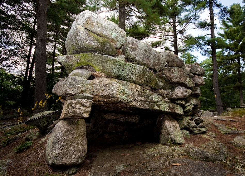
Upton Chamber
This building known as the Upton Chamber, one of the many, was what they called, “unexplained stone works” of the area. But, it is also an extraordinary building due to the fact that it is one of the largest and most perfectly built stone chambers in New England, and is all underground.
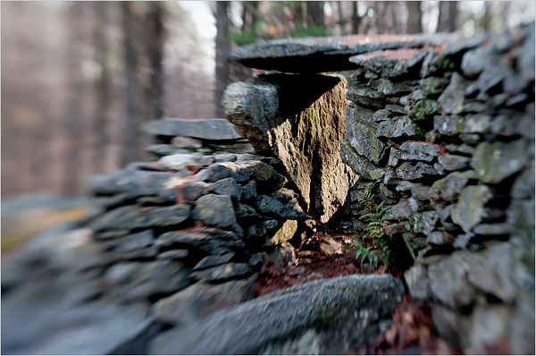
Watch Tower
Known as the Watch Tower and Watch house, this structure leads into a larger interior space. The chamber contains a high percentage of white quartz, a stone found in many Neolithic structures worldwide and treasured by ancient people for its reflective qualities. This chamber is aligned to the February sunrise and lunar minor south. At sunrise on this date the sunlight enters the entrance of the chamber and slowly moves along one wall until it illuminates the quartz crystals at the back wall, making the semi-precious gems sparkle noticeably.
Various websites on the internet claim the stones of Limestone, Quartz, and Megnetite have amazing abilities to generate residual haunting. This is said to be an event of the past which gets imprinted at a certain location and is released into the world. Quartz cut at an angle on it’s axis, with pressure on it generated a minute electrical charge. It transmits short light waves (ultraviolet) better than glass.
I personally believe that these stones are able to perform more paranormal activities than current scientific evidence can prove.
I also think that these antiquated and modern visits from these ‘sky gods’ who these people around the world worship.
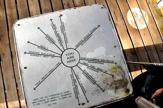
The Oracle Chamber
It too bears a striking resemblance to altar stones found at megalithic sites in Europe. And we do know that blood sacrifice and altars such as these were connected firmly to Neolithic religions.
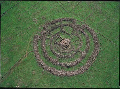
Another frequently occurring megalithic structure familiar to all readers is the stone circle. We know of the great Stonehenge complex in England with its huge Sarcen (meaning “heathen stones” and derived from the word Saracen) stones found there and the many calendrical alignments they delineate. But there are ancient stone circles in New England as well.
http://www.crystalinks.com/mysteryhill.html
Sacrificial Table/Clock
The program inferred this table to a clock, but many other prehistoric sites like this one reveals sacrifices to Baal were a main objective in the worship sequence. This table has grooves which lend the path for blood flow to be caught into a basin beneath the table. A sound effect could be heard from this very spot from the underground Oracle Chamber if one were to speak. This is called Archaeolacoustics and is seen in sites from Mexico pyramids to the Egypt Giza.
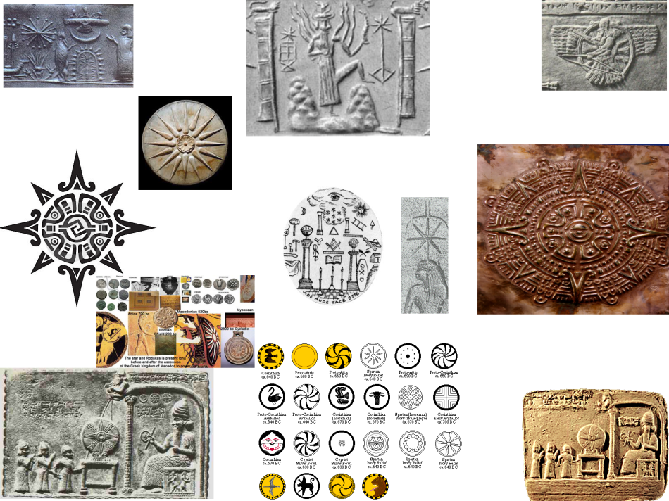
This land contains other anomalies which I found to be interesting on Google Earth. A Triangle marks this circumference of this ancient site. Then we also see a * in the ground. A symbol of the star? Or something else? We find this symbol in other ancient and modern pictures/pictographs.
HERE:
Connections Far & Wide
Purposely shrouded in mystery, these kinds of sites reveal astronomical alignments. Archaeoastromony is the use of the Sun, Moon, stars and planets in archeological architecture and design.
Places all around the earth present us with many interesting theories and questions. But what I really find interesting is the FACT that these sites align. Yes, align.
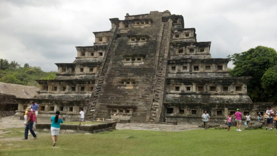
If you bring up GOOGLE EARTH, you can use the map tool and designate the beginning spot at BAALBEK, Beriut…yes the place where the Phoenicians (also called Canaanites in the Bible), to the site here in New Hampshire (America’s Stonehenge) to Mexico! In Mexico, the Pyramid of Niches, also called the “Place of the Dead” aligns to these landmarks. It is also called “PLACE OF THE INVISIBLE BEINGS OR SPIRITS”.
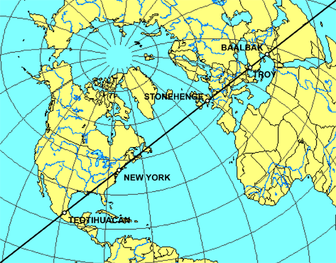
Connecting the New World to the Old World
From Baalbek to New Hampshire down to Mexico, we have sites which can be connected to the mythological legends of Phoenicians (Canaanites) to Atlantis then to the Fallen Angels.
Call it what you will…theory to fact there is no denying that we live in a strange world.
Swedish Stonehenge
Ancient Scandinavians seemed to have arranged their own Stonehenge. Archeologists agree it was assembled more than 1000 years ago, some say 2500!
It too is an astronomical calendar with the same underlying geometry as England’s Stonehenge.
http://www.livescience.com/19747-stonehenge-ales-stenar-astronomical-calendar.html
Gobekli Tepe, Turkey-Mount Nemrut …198 feet of that mountain is completely artificially covered with the same size stones. 30 acres of limestone pillars placed in circles twelve thousand years ago.
[link] http://missiongalacticfreedom.wordpress.com/2012/09/18/part-1-mysterious-12000-year-old-gobekli-tepe/
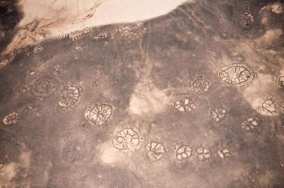
Giant Wheels
The area near the Azraq Oasis in Jordan has hundreds of wheels. These structures made of stone date back at least 2000 years. Often found on the lava fields, these strange anomalies were said to be used as a cemetery.
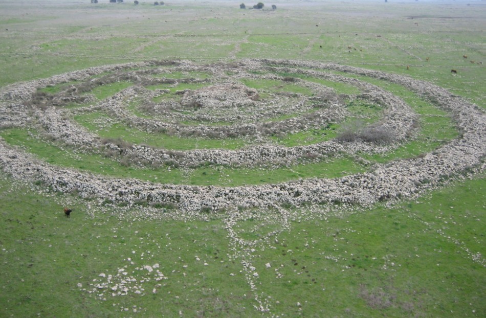
ISRAEL’S STONEHENGE
“The Circle of the Rafaim” or “Wheel of the Rafaim” is one of the most mysterious archeological sites in the world. It is a monument! This monument consists of five concentric stone rings whose diameter is 165 meters. The best preserved of these are the outermost; whose height reaches two meters with a thickness of 3.3 meters.
The central dolmen is built from relatively smaller rocks. Connecting it to are four main stone walls. The first wall, shaped like a semicircle, is 50m in diameter and 1.5m wide. That wall is connected to a second one, an almost complete circle 90m in diameter. The third wall is a full circle, 110m in diameter and 2.6m wide. The fourth and outermost wall is the largest: 150m in diameter and 3.2m wide.
The circles are connected by smaller stone walls. In the center is a mound, or dolmen, approximately 20 meters in diameter and 5 m in height. Some of the stones are used to create the ring weighing 20 tons.
The total weight of the stones is 37,000 tons. In the middle of the rings is a cairn, topped by a tumulus, measuring twenty meters across. Despite the obvious attraction to archaeologists, the rings remained hidden while the suspicious Syrian regimes held the Golan Heights and were only opened to inspection after Israel won the area in the Six Day War of 1967.
Gilgal Refaim גלגל רפאים, is a stone circle and ancient megalithic monument in the Golan Heights, not far from Gamla, some 16 kilometers east of the eastern coast of the Sea of Galilee, in the middle of a large plateau covered with hundreds of dolmens. Nearby is an ancient settlement dating from the Early Bronze Age.
The complex comprises more than 42,000 basalt rocks, arranged in circles. In the center is a mound 5-6 meters tall, from which protrude several layers of stone walls. Some of the walls form complete circles, and others incomplete. The outermost wall has a circumference of close to half a kilometer, and a diameter of more than 150 meters. The site was probably built during the Copper Age, and is estimated to be about 5,000 years old. There are several hypotheses about the site’s purpose, ranging from a calendar, to a tomb or site of worship.
In 1968 Harvard University and Prof. Anthony Aveni of Colgate University discovered that in 3000 BCE, the first rays of the summer solstice would have appeared directly through the northeast opening as seen from the central tumulus. At the same time, the southeast opening provided a direct view of Sirius.
Moshe Hartal, Chief Archaeologist of the Golan explains, “We have identified 8,500 dolmens of twenty separate styles on the Golan Heights. Each tribe had its own dolmen style. The biggest dolmen stones weigh over 50 tons and are seven meters in height. Graves are found within some domens but not all.
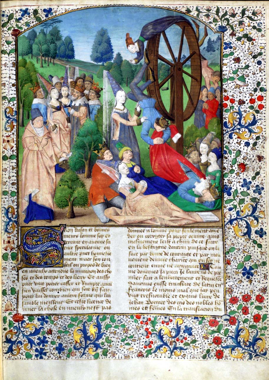
Rota Fortuna, The Wheel of Fortune
|
|
|
|
Reply |
Message 2 of 29 on the subject |
|
|
|
|
Reply |
Message 3 of 29 on the subject |
|
20/04/2009 – Get the latest in science news, including space, physics, planet earth, discoveries , NASA, satellites, and space travel from Wired.com.
America's Stonehenge is open to the public for a fee. Part of a recreational area that includes snowshoe trails and an alpaca farm, it is a tourist attraction, with ...
The structure is sometimes referred to as an "American Stonehenge." The monument is 19 feet 3 inches (5.87 m) tall, made from six granite slabs weighing ...
Outdoor museum located at a 4000 year old prehistoric site in Salem, NH. Features archaeology, astronomy and archaeoastronomy.
15/01/2013 – I was so happy to discover that there are only two episodes left in the first season of America Unearthed. [Update: I am informed that the full first ...
In America Unearthed, forensic geologist Scott Wolter, a real-life Indiana Jones, will reveal that the history ... Stonehenge in America: Wednesday, Jun 26, 9/8c.
The American Stonehenge's reference to establishing a world court ... The message of the American Stonehenge also foreshadowed the current drive for ...
America's oldest archaeological site or muddled case of wishful thinking...
Illustrated description of a megalithic site 40 miles north of Boston, USA, with theories of its builders and use, from The Museum of Unnatural Mystery.
|
|
|
|
Reply |
Message 4 of 29 on the subject |
|
The first 5 American Cities of the American Colonies, right ?
Did you know that they are all on the same exact precise straight line ?
(A great circle, e.g. the Equator, is a straight line on a globe/sphere, aka Great Circle = Riemannian Circle)
Top View "Orthographic Projection" Showing PERFECTLY STRAIGHT LINE
Connecting the 5 "revolutionary" cities in a Stonehenge Sandwich with British
Stonehenge, as well as American Stonehenge, aka Georgia Guidestones.
Did you know that each of these first 5 American cities it is said were surveyed by Sir Walter Raleigh under the secret direction of the Queen of England in the late 1500s & early 1600s while he was supposedly over here setting up the Roanoke Island Colony ?
Did you know that on this same VERY precise Great Circle, extended out from the 5 cities in either direction are the Two Stonehenges, the one in England, circa 3000BC, and the American Stonehenge, aka Georgia Guide-Stones, dedicated in March 22, 1980 according to its engravings, which to this day no one takes credit for erecting ! {the fact that no mention of this is made in the otherwise most excellent film above is further proof of an ongoing conspiracy !}
We verified this ourselves, of course, as you must as well, with this most excellent Great Circle Mapping Tool used by aircraft pilots. (use any tool you like)
Have fun trying other options, like the night view, and the different projections, and please do tell us what other major cities you find on the complete Great Circle, left to you most astute idle reader as an exercise.
Keep in mind this is all FACT, no speculation or obfuscation here, all verifiable BY YOU, unlike so much else today which is nearly impossible to verify, without FAITH or trust of any kind, facts are simply facts, even if they were arranged 400+ years ago !!! Why believe when you can always KNOW the truth ! Stick always with the obvious truth first, avoid speculation always, please, please, please, we beg you. FAITH & TRUST are anathema for the innocently wise who KNOW that the TRUTH is so good, that it is literally BEYOND beLIEf !!! and can only be KNOWN by YOU most sacred friends.
Take no one's word for anything, if faith is required, you are sure to be shorn, why not look into it yourself ? If it is not obvious, you better do your due diligence, TRUST NO ONE, VERIFY EVERYTHING, just as we did with this most impressive GREAT CIRCLE !!! You deserve the truth in everything. Make sure you get it !!! That is just how powerful and beautiful the truth is and why so many hide it from others foolishly !! To not have the truth is not good. Yes it really is that simple. Only lies are complex. The truth is always obvious.
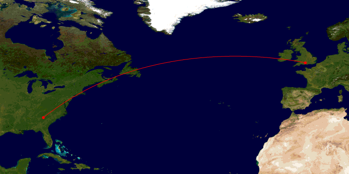
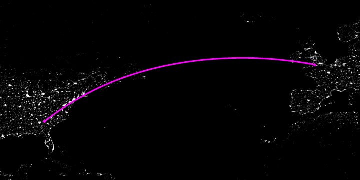
Night shot, showing the 5 cities of DC, Baltimore, Philadelphia, NY & Boston as brightly lit.
Notice DC and Baltimore are very close together as they indeed are.
Orthographic Projection
Polar Aspect Orthographic
|
|
|
|
Reply |
Message 5 of 29 on the subject |
|
Scientists Confirm 10,000 Year Old Structure and Carvings Found in Michigan Breaking News: Stonehenge is discovered in America. Although hard to believe, this is actually a true story. In 2007, a team of archaeologists was hired to survey several ancient boat wrecks in the waters of Lake Michigan when they came across some large stones that were arranged in a circular pattern with one of the stones appearing to have a Mastodon carved into it. The stones were under approximately 40 feet of water and were detected using a new form of sonar. Below is a picture of what the sonar scan revealed with the Stonehenge like structure. lots of skepticism but there ya have it the solar scan under the water shows large stones arranged in a circular pattern like Stonehenge 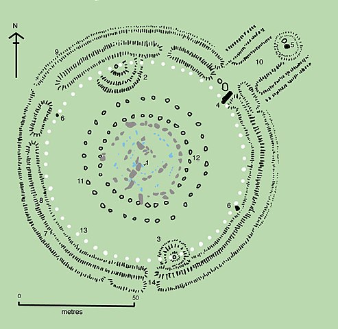
_________________
Everything is Connected and there are no
coincidences |
|
|
|
|
Reply |
Message 6 of 29 on the subject |
|
The Oracle Chamber
It too bears a striking resemblance to altar stones found at megalithic sites in Europe. And we do know that blood sacrifice and altars such as these were connected firmly to Neolithic religions.
Another frequently occurring megalithic structure familiar to all readers is the stone circle. We know of the great Stonehenge complex in England with its huge Sarcen (meaning “heathen stones” and derived from the word Saracen) stones found there and the many calendrical alignments they delineate. But there are ancient stone circles in New England as well.
http://www.crystalinks.com/mysteryhill.html
|
|
|
|
|
Reply |
Message 7 of 29 on the subject |
|
Baalbek
De Wikipedia, la enciclopedia libre
- Este artículo es sobre Heliópolis syriae (en el actual Líbano). Para otros usos ver Heliópolis (desambiguación)
Baalbek, en árabe Ba'lbakk (بعلبك), es actualmente una localidad de Líbano de 25.000 habitantes a 86 km al este de Beirut. La economía se basa en el cultivo de viñas y árboles frutales. En la antigüedad fue un santuario fenicio dedicado al dios Baal; fue ciudad griega, y a partir de la época de los seléucidas se le llamó Heliópolis, siendo colonia romana desde Augusto. Según algunas versiones cristianas Santa Bárbara (mártir) vivió en esta ciudad.
Es uno de los yacimientos arqueológicos más importantes del cercano oriente, declarado Patrimonio de la Humanidad por la Unesco en 1984. Es notable una zona de templos de entre los siglos I-III d.C. en honor de la Tríada heliopolitana: Júpiter, Mercurio y Venus. Las primeras excavaciones se iniciaron hacia 1900.
Historia del yacimiento[editar]
Los orígenes de Baalbek se remontan a dos asentamientos cananitas que las excavaciones arqueológicas bajo el templo de Júpiter han permitido datar su antigüedad, siendo de la edad del bronce antigua (2900-2300 a. C.) y media (1900-1600 a. C.).
La etimología del topónimo está relacionada al sustantivo bá'al o bēl que en varias lenguas del área semítida noroccidental (como el hebreo o el acadio) significa "señor". El término Baalbek significaría entonces "señor de la Bekaa" y estaría, probablemente, relacionado con el oráculo y el santuario dedicado al dios Baal o Bēl (a menudo identificado como Hadad, dios del sol, de la tempestad y de la fertilidad de la tierra) y a Anat, diosa de la violencia y de la guerra, hermana y consorte de Baal (más tarde se identificaría con Astarté), quizá asociada a Tammuz (más adelante identificado con Adonis), dios de la regeneración primaveral. Las prácticas religiosas de estos templos contemplaban seguramente, como en otras culturas vecinas, la prostitución sacra, los sacrificios animales (y quizá también humanos) y las ofrendas rituales a las divinidades.
La ciudad, situada en una posición favorable desde el punto de vista estratégico, cerca de las fuentes de los ríos Orontes y Litani, no tendría de todas maneras, al menos inicialmente, un importante valor comercial y estratégico, no siendo mencionada en las fuentes egipcias y asirias.
La identificación con la bíblica Baal-Gad (Libro de Josué 11,17; 12,7), recogida como el límite septentrional de la conquista de Josué, es hoy contestada, sosteniendo más bien que la localidad bíblica se debe identificar con la ciudad de Ḥāṣbayyā, en el sureste de Líbano, o tal vez con Bāniyās (la antigua Cesarea de Filipo), sobre los Altos del Golán.
Fase helenística[editar]
El historiador hebreo Flavio Josefo (siglo I) recoge el paso de Alejandro Magno por Baalbek en su marcha hacia Damasco. En la época helenística, bajo el dominio de la Dinastía Ptolemaica, y a partir de 198 a. C. por el Imperio Seléucida, la ciudad fue rebautizada con el nombre de Heliópolis ("ciudad del sol"). Los soberanos ptolemaicos favorecieron probablemente la identificación del dios Baal con el dios del sol egipcio, Ra, y el dios griego Helios, con el fin de cementar una mayor fusión cultural en el interior de sus propios territorios.
El patio del templo fue modificado en su extremidad occidental, iniciándose la construcción de un templo de formas griegas por el cual se construye una gigantesca plataforma (88 por 48 metros). Para esta construcción son empleados bloques colosales: los tres que constituyen el llamado τρίλιθον (trilithon) pesan cerca de 750 toneladas cada uno, mientras un cuarto bloque, de dimensiones incluso mayores (21,5 metros de longitud, con una sección cuadrada de 4,3 metros de lado), hoy conocido con el nombre de ﺣﺠﺮ ﺍﻠﺤﺒﻠﻰ (ḥaǧar al-ḥublā o "piedra de la gestante"), fue abandonado en la cantera.
Fase romana[editar]
Tras la conquista romana de la ciudad en el 64 a. C., la divinidad del santuario fue identificada con Júpiter, conservando todavía alguno de las características de la antigua divinidad indígena y asumiendo la forma y el nombre de Júpiter Heliopolitano. El dios estaba representado con rayos en las manos y encuadrado entre dos toros, el animal que acompañaba al dios Baal. Los otros dioses asociados fueron identificados con Venus y Baco. El culto asume un carácter mítico y misterioso, lo que favoreció probablemente su difusión.
En el 15 a. C. el santuario entró a formar parte del territorio de la Colonia Iulia Augusta Felix Beritus, actual Beirut. La edificación del templo fue nuevamente emprendida sobre la plataforma helenística y concluye en diversas etapas: el templo propio y verdadero (templo de Júpiter), fue terminado en el 60, bajo Nerón. A la vez es edificado el altar a torre que precede al templo. Bajo Trajano (98-117) se inició la construcción del gran patio. Bajo Antonino Pío (138-161) es erigido el templo de Baco. Los trabajos, incluso aquellos referidos al templo de Venus, fueron completados durante la dinastía de los Severos, particularmente durante el gobierno de Caracalla (211-217). Bajo Filipo el Árabe (244-249), emperador romano de la vecina Damasco, fue construido el patio hexagonal del santuario.
En esta época Heliópolis, elevada por Septimio Severo (193-211) al rango de colonia de derecho itálico con el nombre de Colonia Iulia Augusta Felix Heliopolis”, se convierte en el centro principal de la provincia de Siria-Fenicia, instituida en el 194 con capital en Tiro.
Fase árabe-islámica[editar]

El "Gran Patio" del Templo de Júpiter.
Descubrimiento europeo y misiones arqueológicas[editar]

Las columnas del templo de Júpiter.
En el siglo XVIII los exploradores europeos descubrieron las ruinas del santuario y reportaron detalladas descripciones y planos del lugar. En el 1751 Robert Wood describe las ruinas como entre las obras más audaces de la arquitectura de la antigüedad. Quedaban en pie nueve columnas del templo de Júpiter, pero tres se derrumbaron, posiblemente como consecuencia del terremoto del 1759. Otros viajeros fueron Volney (1871), Cassas (1875), Laborde (1837) y David Roberts (1839).
Una primera expedición científica fue realizada en el 1873 por el Fondo de Exploraciones de Palestina, y siguió de una visita del emperador Guillermo II de Alemania que llevó al establecimiento de una misión arqueológica alemana (1898-1905), dirigida por Otto Puchstein, durante la cual fueron efectuadas las primeras restauraciones. Después de la Primera Guerra Mundial, se establecieron otras misiones durante el Mandato francés, obra de C. Virolleaud, R. Dassaud, S. Ronzevalle, H. Seyrig, D. Schlumberger, F. Anus, P. Coupel y P. Collard. Luego de la independencia de Líbano, en el 1943, las operaciones de restauración y conservación pasaron a ser jurisdicción de Servicio de la Antigüedad del Líbano. En 1984 el yacimiento de Baalbek es inscrito en las listas de los Patrimonio de la Humanidad de la Unesco.
Descripción del santuario[editar]

Esquema planimétrico del santuario de Júpiter y del templo de Baco (A : templo de Júpiter; B : templo de Baco; C : Patio hexagonal; D: Gran patio.).
Fueron construidos en los inicios del siglo III, en la época de Caracalla encima de una escalinata monumental y constituían el acceso al área sagrada del templo de Júpiter. En origen formaban parte de una fachada de 12 columnas, entre dos torres muy altas, sobre la que se asentaba un frontón.
En el muro restante se abría un ingreso central por el arco y dos pasos laterales, que más tarde fueron tapiados. El muro estaba decorado por dos pisos de hornacinas que en origen debían albergar estatuas, encuadradas por un pequeño santuario con frontones alternativamente triangulares y arqueados, sostenidos por lesenas de orden corintio en la planta baja y de orden jónico en la planta superior.
Patio hexagonal[editar]
De los propileos se accedía a un patio de planta hexagonal (mitad del siglo III, bajo Filipo el Árabe), circundado por pórticos que se abría sobre el fondo con exedras rectangulares, un templo ricamente decorado. El patio sufrió importantes modificaciones en la época en la que fue instalada la capilla dedicada a la Virgen y sucesivamente por la transformación en bastión defensivo de la ciudadela árabe.
Templo de Baco[editar]

Fachada lateral del templo de Baco.
Elevado sobre un podio de 5 metros de altura, mide 69 por 36 metros y se accede a él por una escalinata con 33 peldaños. Estaba precedido por patio porticado con un acceso monumental. Se remonta a la mitad del siglo II (Antonio Pío, 128-161) y se trata de un templo períptero con ocho columnas sobre el frente ("octástilo") y quince sobre los lados largos, estando muy bien conservado (salvo el techo de la cella y parte de las columnas laterales). Las columnas estriadas alcanzaban con basa y capitel una altura de 19 metros y también en este caso el friso estaba decorado con prótomes de toros y leones.
Baalbek en la actualidad[editar]
|
|
|
|
Reply |
Message 8 of 29 on the subject |
|
El misterio de Baalbek
Baalbek (o Balbek) se encuentra en el este del Líbano, en el famoso valle de Beqa’a, entre los ríos Litani y Asi. Se localiza en el cruce de dos rutas comerciales de importancia histórica, una entre el Mediterráneo y la Siria Interior, y la otra entre el norte de Siria y el Norte de Palestina.

Localización de Baalbek
Los orígenes de Baalbek son un misterio. Se ha supuesto que inicialmente fue una ciudad fenicia, centro del culto al dios babilónico Baal-Hadad, y su nombre significaría “Ciudad de Baal”; posteriormente, los griegos asimilarían esta deidad a Helios, de ahí que pasara a llamarse Heliópolis. Sin embargo, no existe ninguna evidencia arqueológica de ese supuesto asentamiento fenicio inicial, y dada la ausencia de referencias en las fuentes históricas de un asentamiento semejante, lo más probable es que éste haya sido o de muy escasa importancia o, mucho más probablemente, inexistente. El nombre “Baalbek” no denota una inconmensurable antigüedad. Ni se usó durante la época romana, ni existe evidencia de que se haya utilizado alguna vez con anterioridad a ésta. No parece muy probable que el sitio comenzara a llamarse “Baalbek” en honor a un Baal cualquiera en tiempos posteriores, pues para entonces la región ya se había cristianizado, para ser más tarde sometida por el Islam.
Las primeras referencias firmes acerca de la ciudad datan precisamente del período posterior a la conquista romana.

Baalbek
La famosa terraza de Baalbek es una de las principales bazas de los defensores de la hipótesis de los “Antiguos Astronautas“, según la cual, en un pasado lejano, habitantes de otros mundos habrían visitado la Tierra. Esos navegantes de los espacios interestelares habrían dejado como prueba de su paso mitos dispersos y edificios inexplicables.
La Gran Terraza es una plataforma construida con las mayores piedras talladas conocidas, bloques megalíticos que fueron cortados con gran precisión y colocados para formar unos fundamentos de 460.000 metros cuadrados de superficie. En esta plataforma se encuentran los tres colosales bloques conocidos como el Trilithon, cada uno de los cuales mide casi 20 metros de largo, con una altura de aproximadamente 4 metros y un ancho de 3. El peso de cada uno de esos monolitos monstruosos se ha estimado entre mil y dos mil toneladas; son de granito rojo, y fueron extraídos de la cantera a más de un kilómetro de distancia, valle abajo respecto a la construcción.

Una de las 3 piedas del Trilithon
Aún es más extraordinario el hecho de que en la cantera haya quedado un bloque aún mayor, conocido por los árabes como Hajar el Gouble, o Piedra del Sur.

En 1851, el estudioso francés Louis Felicien de Saulcy, quien más tarde realizaría una de las primeras excavaciones sistemáticas de Jerusalén, permaneció en Baalbek dos días, del 16 al 18 de mayo, y se convenció de que el basamento de la Gran Terraza eran los restos de un templo prerromano; dejó sentada esta opinión en su libro “Voyage autour de la Mer Morte” (“Viaje alrededor del Mar Muerto”) que data de 1864.
La hipótesis del origen extraterrestre de la terraza de Baalbek aún tardaría en llegar. El primero en exponerla fue el físico bielorruso Matest M. Agrest, en 1959. Agrest es considerado como el primer científico en avanzar la hipótesis de que la Tierra fue visitada en tiempos prehistóricos por inteligencias venidas del espacio exterior; su famoso artículo “Astronautas de la Antigüedad” (Kosmonauty Drevnosty) se publicó en 1961. En sus hipótesis, Agrest le da una gran importancia a la historia bíblica de Enoch, y a la oscura referencia del Génesis que habla de los Nefilin. Propuso, asimismo, que las tectitas son prueba de esas visitas extraterrestres y que lo que realmente ocurrió en Sodoma y Gomorra fue una explosión nuclear. Para Agrest, la Gran Terraza habría sido una pista de aterrizaje para los cosmonautas de la antigüedad. Curiosamente, la única fuente de información de Agrest respecto a Baalbek parece haber sido un indefinido libro publicado en París en 1898.

La hipótesis de Agrest respecto a Baalbek en particular, y a los “antiguos astronautas” en general, hizo escuela. Zacharia Sitchin y Däniken siguen también esta misma línea. Las innumerables toneladas de los bloques de Baalbek parecen ser tan fascinantes que existen autores que no se resisten a mencionarlas, aunque no tengan nada que ver con el tema del que están tratando; por ejemplo, Charles Berlitz, quien en medio de un catálogo de maravillas que aparece en su magna obra “El Triángulo de las Bermudas” menciona “las enormes piedras de las fundaciones del templo de Júpiter (NEXO SANTA CENA = SACERDOCIO DE MELQUISEDEC), en Baalbek, Siria, emplazadas allí mucho antes de la construcción del templo y una de las cuales pesa 2.000 toneladas”. Por cierto, en la actualidad Baalbek no queda en Siria, sino en el Líbano, pero pasémosle por alto este pequeño lapsus.
Es de hacer notar que las especulaciones que atribuyen la Terraza de Baalbek a la acción de los “antiguos astronautas” parten de dos supuestos básicos: que la plataforma fue construida en un pasado muy remoto, mucho antes de los templos que la coronan, que el peso de los grandes bloques supera la capacidad de transporte de la tecnología humana de la época en que se levantó la plataforma (¡y aún en el día de hoy!). Pero ¿son ciertas estas suposiciones? Si seguimos al pie de la letra la leyenda, tal y como se repite una y otra vez, sólo podemos concluir que las ruinas de Baalbek son simplemente imposibles e inexplicables, un misterio sin solución humana.
En los años 1904 – 1905 una expedición alemana realizó la primera excavación sistemática en las ruinas de Baalbek. Los arqueólogos alemanes excavaron a través de la plataforma y realizaron hallazgos muy interesantes. La aparentemente sólida terraza está construida de sólidos megalitos únicamente en sus muros externos. En el interior, bajo el foro, encontraron un laberinto de cámaras rellenas de escombros compactados, con paredes de ladrillo en la típica forma romana de panal; debajo de todo esto, el lecho de roca sólida. En resumen, sólo albañilería y restos romanos. Los cimientos de los templos están fundamentados en el lecho de rocas para poder soportar su peso, ya que la plataforma simplemente se hundiría si descansaran sobre ella. Las paredes megalíticas son en realidad un muro de contención en declive.
Del supuesto asentamiento fenicio previo no se encontraron restos, ni tampoco de ningún otro de una inconmensurable antigüedad. Mucho menos, restos de equipos de láser, pilas de fusión atómica o motores de plasma.
Uno de los recursos más efectivos e impresionantes de los que se sirvieron los ingenieros y arquitectos romanos fue la creación de masivas plataformas en terrazas para soportar grandes edificios o grupos de ellos. Esta idea venía de Grecia, pero fueron los romanos quienes lograron desarrollar todas las ventajas estructurales de construir masivas subestructuras para explotar el potencial funcional de lugares geográficamente accidentados. Ejemplos de estas terrazas se han encontrado en Tiddis (África del Norte), Terracina (Italia), Praeneste (Palestina), y muchos otros sitios.
La conclusión, por extraño que parezca, es que, de acuerdo a los datos disponibles, el emplazamiento es de origen romano. Ni fenicio, ni extraterrestre. Y en cualquier caso, como pista de aterrizaje hubiera resultado francamente deficiente, pues cualquier nave espacial de regular peso hubiera hundido el pavimento.
¿Y los bloques del famoso Trilithon? ¿Cómo es posible que hayan sido desplazados desde la cantera hasta su posición final en la plataforma, por los romanos o por quien fuera?
Aquí son necesarias algunas precisiones. La primera: los bloques no son tan pesados como suelen afirmar los divulgadores de la hipótesis de los “antiguos astronautas”. Ya vimos que von Daeniken les atribuye “casi 2.000 toneladas” y “20 metros de lado”; esto último hace pensar de inmediato en un monstruoso cubo, pero en realidad se trata de “aproximadamente 20 metros de largo”, ya que cada megalito tiene forma de paralelogramo. Berlitz sigue a von Daeniken en el dislate, y habla también de “2.000 toneladas”. Puestos a fantasear, no falta quien les atribuya “millones de toneladas”. Todo esto hace sospechar que existe mucha gente que habla del tema sin molestarse en hacer algunas comprobaciones elementales, para las cuales no es necesario viajar a Baalbek ni excavar en la plataforma. Todo lo que se requiere es conocer la densidad del granito, las dimensiones de los bloques y una modesta calculadora de mano.
La densidad del granito, dependiendo de su tipo, varía entre 2,63 y 2,75 g/cm3. Respecto a las dimensiones de los bloques, no hay dos fuentes que den las mismas medidas; sin embargo, todas coinciden en que ninguno llega a los 20 metros de largo. Según parece, el mayor de los megalitos del Trilithon mide 19,80 por 4 por 3,6 metros. Esto daría un volumen de 285,12 m3. Asumiendo que la densidad de la piedra es de 2,75 g/cm3, el peso del bloque sería de 784,08 toneladas. Por debajo de las 800 toneladas y muy lejos de las 2.000 que Daeniken y Berlitz citan tan alegremente. Por supuesto, en este cálculo casero pueden haberse filtrado varios errores: las piedras pueden tener unas dimensiones reales un poco mayores (¡o menores!) que las mencionadas; la densidad del granito puede ser menor que 2,75 g/cm3 (intencionalmente he usado el valor mayor que he encontrado y no el menor); en la conversión de pies a metros siempre se pierden algunos decimales. De hecho, existen estimaciones aún más moderadas y probablemente más precisas, en torno a las 600 toneladas, y en todo caso, siempre por debajo de las 800.
En cuanto a la piedra más pesada, la llamada “Piedra del Sur” (otras fuentes le dan el nombre de “Piedra de la Mujer Preñada”), esta sí pesa más de 1.000 toneladas. Mide nada menos que 21,31 metros de largo, por 4,08 por 4,72, para un volumen de algo más de 410 m3. Diversas estimaciones le atribuyen un peso entre 1.050 y 1.200 toneladas (mi cálculo casero da aproximadamente 1.127 toneladas). Aunque estamos aún muy lejos de las “2.000 toneladas”, de todas formas resulta impresionante. Salvo por un detalle, que siempre se menciona de pasada y sin darle mayor importancia: este fenomenal pedrusco no llegó a salir de la cantera, por lo que de ningún modo se puede hacer un misterio de su transporte, ya que simplemente no fue transportado a ninguna parte. ¿Por qué dejaron los ingenieros romanos este monstruo en la cantera? A este respecto, y a falta de documentos, sólo se pueden aventurar hipótesis: quizás cometieron un error de cálculo y se encontraron con que habían tallado un bloque demasiado grande y que luego les fue imposible mover, o quizás modificaron el proyecto de la obra, o… En cualquier caso, la misma pregunta habría que hacérsela a los que le atribuyen el bloque a la tecnología alienígena.
Sigamos con las precisiones. La cantera de donde se extrajeron los famosos bloques no se encuentra “valle abajo” respecto a la construcción; se encuentra entre 10 y 15 metros por encima de ella. La cantera está a 1.160 metros de altura y el templo a unos 1.145. Indudablemente siempre resultará más fácil transportar una gran masa cuesta abajo que cuesta arriba. Por otra parte, la cantera se encuentra a sólo 600 metros de la plataforma, aunque al tener que sortear una zanja, la distancia a recorrer se alarga hasta unos 1.100 metros.
Sin embargo, podría parecer que aunque algo minimizado, el misterio aún persiste. ¿Tenían los romanos la capacidad técnica para movilizar bloques de semejante peso, aunque fuera en una distancia relativamente corta?
Los ingenieros romanos fueron expertos en la movilización de bloques pétreos de gran tamaño, incluso en condiciones mucho más difíciles que las que pudieran haberse dado en Baalbek, donde la cantera se encontraba relativamente próxima. Durante la época imperial, muchos obeliscos egipcios fueron transportados desde sus emplazamientos de origen hasta la península itálica; al menos una docena de éstos fueron erigidos de nuevo en Roma misma. Entre éstos el que actualmente se encuentra en la plaza de San Juan de Letrán, erigido inicialmente por Tutmosis III en Karnak, hacia el siglo XV a.C. Su altura es de 32 metros, los lados de la base miden 2,70 y los de la cúspide 1,88.
Durante el reinado de Teodosio I (379-395), otro obelisco procedente de Karnak fue colocado en la “spina” del hipódromo de Constantinopla. Los detalles al respecto se conocen a través de la obra del historiador bizantino Marcelino Comes (siglo VI d.C.) y por las inscripciones en el plinto de mármol de seis metros de alto sobre el que fue erigido. Este obelisco mide 19,59 metros de altura. Los relieves de la cara norte del plinto muestran escenas de la erección del monumento, bajo la vigilancia atenta del Emperador. Estos relieves son un valioso registro de las técnicas de la época.
El obelisco tuvo que ser trasladado una distancia de alrededor de tres kilómetros en subida desde el nivel del mar hasta su emplazamiento final en el hipódromo, mientras que en Baalbek la distancia fue bastante menor y cuesta abajo. Para realizar el trabajo, los romanos no dependían de la pura fuerza bruta de un ejército de esclavos tirando al unísono a una orden del capataz, sino que empleaban máquinas diseñadas ex profeso. Una de las novedades tecnológicas introducidas por los ingenieros romanos fue el amplio uso del movimiento rotatorio; por ejemplo, el uso de grúas potenciadas por norias. Para el traslado de bloques de gran peso, utilizaban malacates, en los que el movimiento rotatorio se transformaba en tracción.
El transporte del obelisco de Teodosio se logró al parecer con doce malacates, manejado cada uno por veinticuatro hombres.
Los malacates eran colocados en postes enterrados en el suelo a los lados de la vía de transporte, en dos hileras paralelas, a ambos lados del bloque a desplazar; cada malacate se ubicaba a cinco metros del siguiente. Cada una de las parejas de malacates de cada lado tenían un ángulo diferente para halar el peso. Cuando el ángulo de dos de los malacates era impracticable, los malacates se desmontaban y se colocaban más adelante. Por supuesto, el transporte era lento (se ha estimado en unos 30 metros diarios), por la necesidad de desmontar y volver a montar las máquinas cada pocos metros para aprovechar mejor la fuerza. Sin embargo, en vista de que en Baalbek se movieron varios bloques, es posible que los malacates se hayan armado en forma de callejón sin llegar a desmontarlos, para utilizarlos con los bloques sucesivos. El traslado de cada bloque hubiera sido así algo más rápido.
Conclusión
Sin la menor duda, la construcción de Baalbek fue una verdadera hazaña. Pero una hazaña humana, no el producto de alguna privilegiada mente extraterrestre. Si bien no ha alcanzado aún, ni quizás alcance nunca, la fama de la Gran Pirámide, Baalbek sigue siendo una referencia ineludible a la hora de especular sobre viajeros procedentes del espacio exterior. En rigor, su misterio ni siquiera debiera haber nacido, pues ya en 1905 no era misterio. Y sin embargo, la misma historia sigue repitiéndose una y otra vez…
Referencias:
http://intercosmos.iespana.es/reportajes/ciencia/baalbek.htm
http://www.akasico.com/noticia.asp?ref=1217
http://en.wikipedia.org/wiki/Baalbek
http://www.paleoastronautica.com/088_baalbek.html
|
|
|
|
Reply |
Message 9 of 29 on the subject |
|
The Georgia Guidestones
Introduction
In Elbert County, Georgia (USA), there is a nearly 6m tall monument made of six astronomically aligned granite slabs; there is a capstone, one slab stands in the center, and around it stand four vertical slabs. The north/south pair of vertical granite is aligned to the poles. The central hollow of the structure is designed to be lit by light from the sun at noontime no matter the time of year. The entire monument weighs in at an appreciable 118 tons, and is fitted with a small hole that will allow one to stand at the base and observe the North Star. An additional stone tablet, which is set in the ground a short distance to the west of the structure, provides some clarifying notes on the history and purpose of the Guidestones.

The Georgia Guidestones are supposed to be a Stonehenge replica of sorts, but also a time capsule, and a Rosetta Stone to mutant societies of the far-flung future.
A message consisting of a set of ten guidelines or principles is engraved on the Georgia Guidestones
in eight different languages, one language on each face of the four large upright stones.
Location
Coordinates: 34°13′55″N 82°53′40″W Google Earth: 34.231944, -82.894444
The Georgia Guidestones are located on a hilltop in Elbert County, Georgia, approximately 90 miles (145 kilometers) east of Atlanta, 45 miles (72 km) from Athens (precise distance is 44.3322 miles), GA and 9 miles (15 kilometers) north of the center of Elberton. The stones are standing on a rise a short distance to the east of Georgia Highway 77 (Hartwell Highway), and are visible from that road. Small signs beside the highway indicate the turnoff for the Guidestones, which is identified by a street sign as "Guidestones Rd."
Astronomical Alignment
An eye-level, oblique hole is drilled from the South to the North side of the center, Gnomon stone, so that the North Star is always visible, symbolizing constancy and orientation with the forces of nature.
A slot is cut in the middle of the gnomon stone to form a window which aligns with the positions of the rising sun at the Summer and Winter Solstices and at the Equinox, so that the noon sun shines to indicate noon on a curved line.
The cap stone includes a calendar of sorts, where sunlight beams through a 7/8 inch hole at noon, and shines on the South face of the center stone. As the sun makes its travel cycle, the spot beamed through the hole can tell the day of the year at noon each day. Allowances are made because of variations between standard time and sun time to set the beam of sunlight at an equation of time.
The site was chosen because it commands a view to the East and to the West and is within the range of the Summer and Winter sunrises and sunsets. The stones are oriented in those directions.
History
Joe H. Fendley, Sr., Elberton Granite Finishing Company Inc.'s President, said it all began late on a Friday afternoon in June 1979 when a well-dressed and articulate man walked into his offices in Elberton and wanted to know the cost of building a large monument to conservation. He identified himself as "Mr. Christian." He told Fendley that he represented a small group of loyal Americans living outside Georgia who wished to remain anonymous forever, and that he chose the name "Christian" because he was a Christian. He inquired where Fendley banked and Joe put him in touch with both local banks. Wyatt C. Martin, President of the Granite City Bank, was selected by "Mr. Christian" to be the intermediary for the mysterious project.
According to Martin, the man showed up at his office 30 minutes later, explained the project, and said after completion he hoped other conservation-minded groups would erect even more stones in an outer ring and carry the monuments message in more languages. He told Martin that he wanted the monument erected in a remote area away from the main tourist centers. The gentleman also said that Georgia was selected because of the availability of excellent granite, generally mild climate, and the fact that his great-grandmother was a native Georgian.
Martin persuaded the mystery man that Elbert County was the ideal location for the memorial; and he agreed, provided a suitable location could be found. He returned later and he and Martin inspected sites. "Mr. Christian", who now called himself "R. C. Christian", chose a five-acre plot on the farm of contractor Wayne Mullenix. It is the highest point in Elbert County. A few weeks later , Martin contacted Joe Findley and told him that funds for the project were in an escrow account and to start work immediately. Martin promised that when the project was completed, he would deliver his file on the affair to the anonymous sponsors and that the secret would never be known.
He said "Christian" told him that the sponsors had planned the monument for years and that the ten "guides" for the conservation of mankind and the earth were carefully worded as a moralistic appeal to all peoples of nationality, religion, or politics.

The Georgia Guidestones. Image source: Robert's Elberton
The project was one of the most challenging ever for his quarrying and monument manufacturing concern - partly because of the magnitude of the materials and partly because of the exacting specifications from the mysterious group of sponsors, "and those specifications were so precise that they had to be compiled by experts on stone as well as construction," said Fendley.
The main cluster was completed on March 22, 1980, using granite quarried from nearby Elberton.
The message
A message consisting of a set of ten guidelines or principles is engraved on the Georgia Guidestones in eight different languages, one language on each face of the four large upright stones. Moving clockwise around the structure from due north, these languages are: English, Spanish, Swahili, Hindi, Hebrew, Arabic, ancient Chinese, and Russian.
|
The message in English reads:
MAINTAIN HUMANITY UNDER 500,000,000
IN PERPETUAL BALANCE WITH NATURE
GUIDE REPRODUCTION WISELY —
IMPROVING FITNESS AND DIVERSITY
UNITE HUMANITY WITH A LIVING
NEW LANGUAGE
RULE PASSION — FAITH — TRADITION
AND ALL THINGS
WITH TEMPERED REASON
PROTECT PEOPLE AND NATIONS
WITH FAIR LAWS AND JUST COURTS
LET ALL NATIONS RULE INTERNALLY
RESOLVING EXTERNAL DISPUTES
IN A WORLD COURT
AVOID PETTY LAWS AND USELESS
OFFICIALS
BALANCE PERSONAL RIGHTS WITH
SOCIAL DUTIES.
PRIZE TRUTH — BEAUTY — LOVE —
SEEKING HARMONY WITH THE
INFINITE
BE NOT A CANCER ON THE EARTH —
LEAVE ROOM FOR NATURE —
LEAVE ROOM FOR NATURE
Click of the photo to enlarge >>
|
 |
A shorter message appears on the four vertical surfaces of the capstone, again in a different language and script on each face.
The explanatory tablet near the Guidestones identifies these languages/scripts as Babylonian Cuneiform (north), Classical Greek (east), Sanskrit (south), and Egyptian Hieroglyphs (west), and provides what is presumably an English translation:
"Let these be guidestones to an age of reason."
The phrase Let these be guidestones to an age of reason is a reference to the book, The Age of Reason, by Thomas Paine and appears to be a nod to Thomas Carlyle's Sartor Resartus.
Explanatory tablet
A few feet to the west of the artifact, an additional granite ledger has been set level with the ground. This tablet identifies the structure and the languages used on it, lists various facts about the size, weight, and astronomical features of the stones, the date it was installed, and the sponsors of the project. It also speaks of a time capsule buried under the tablet, but the positions on the stone reserved for filling in the dates on which the capsule was buried and is to be opened are missing, so it is not clear whether the time capsule was ever put in place. The tablet is with one edge to each of the cardinal directions, and is inscribed such that the northern edge is the "top" of the inscription.

The explanatory tablet, immediately west of the edifice. Click to enlarge.
The complete text of the explanatory tablet is detailed below.
The accompanying image shows the overall layout. The tablet is somewhat inconsistent with respect to punctuation, and also misspells "pseudonym".
The original spelling, punctuation, and line breaks in the text have been preserved in the transcription which follows.
The text of the tablet is as follows:
At the center of each tablet edge is a small circle, each containing a letter representing the appropriate compass direction (N, S, E, W).
At the top center of the tablet is written:
THE GEORGIA GUIDESTONES
CENTER CLUSTER ERECTED MARCH 22, 1980
Immediately below this is the outline of a square, inside which is written:
LET THESE BE
GUIDESTONES
TO AN AGE
OF REASON
Around the edges of the square are written the names of four ancient scripts/languages, one per edge. Starting from the top and proceeding clockwise, they are:
BABYLONIAN CUNEIFORM
CLASSICAL GREEK
SANSKRIT
EGYPTIAN HIEROGLYPHICS
("Egyptian Hieroglyphics" is not properly the name of a script; a better name would be "Demotic.")
On the left side of the tablet is the following column of text:
ASTRONOMIC FEATURES:
- CHANNEL THROUGH STONE
INDICATES CELESTIAL POLE.
- HORIZONTAL SLOT INDICATES
ANNUAL TRAVEL OF SUN.
- SUNBEAM THROUGH CAPSTONE
MARKS NOONTIME THROUGHOUT
THE YEAR
AUTHOR: R.C. CHRISTIAN
(A PSEUDONYN)
SPONSORS: A SMALL GROUP
OF AMERICANS WHO SEEK
THE AGE OF REASON
TIME CAPSULE:
PLACED SIX FEET BELOW THIS SPOT
ON TO BE OPENED ON
The words appear as shown under the time capsule heading; no dates are engraved. (The word pseudonym is misspelled on the stone.)
On the right side of the tablet is the following column of text:
PHYSICAL DATA
- OVERALL HEIGHT - 19 feet 3 inches (5.9 m)
- TOTAL WEIGHT - 237, 746 POUNDS
- FOUR MAJOR STONES ARE 16 feet (4.9 m),
FOUR INCHES (102 mm) HIGH, EACH WEIGHING
AN AVERAGE OF 42, 437 POUNDS.
- CENTER STONE IS 16 feet (4.9 m), FOUR-
INCHES HIGH; WEIGHS 20, 957
POUNDS.
- CAPSTONE IS 9 feet (2.7 m), 8-INCHES
LONG; 6 feet (1.8 m), 6-INCHES WIDE;
1-foot (0.30 m), 7-INCHES THICK. WEIGHS
24,832 POUNDS.
- SUPPORT STONES (BASES) 7-FEET,
4 INCHES LONG 2 feet (0.61 m) WIDE.
1-foot (0.30 m), 4 INCHES THICK, EACH
WEIGHING AN AVERAGE OF 4,875
POUNDS.
- SUPPORT STONE (BASE) 4-FEET,
2 1/2 INCHES LONG, 2 feet (0.61 m), 2-INCHES
WIDE; 1-foot (0.30 m), 7-INCHES THICK.
WEIGHT 2,707 POUNDS.
- 951 cubic feet (26.9 m3) GRANITE.
- GRANITE QUARRIED FROM PYRAMID
QUARRIES LOCATED 3 MILES WEST
OF ELBERTON, GEORGIA.
Below the two columns of text is written the caption:
GUIDESTONE LANGUAGES:
Below this is a schematic diagram of the upright stones of the structure, consisting of a small rectangle surrounded by four longer rectangles projecting to the northwest, northeast, southwest and southeast. The names of eight modern languages are inscribed along the long edges of the projecting rectangles, one per edge. Starting from due north and moving clockwise around the diagram (so that the upper edge of the northeast rectangle is listed first), they are:
ENGLISH
SPANISH
SWAHILI
HINDI
HEBREW
ARABIC
CHINESE
RUSSIAN
At the bottom center of the tablet is the following text:
ADDITIONAL INFORMATION AVAILABLE AT
ELBERTON GRANITE MUSEUM & EXHIBIT
COLLEGE AVENUE
ELBERTON, GEORGIA
The Controversy
The Guidestones are of particular interest to mystery fans and conspiracy theorists.
The specific world population guideline: "Maintain Humanity under 500,000,000 in perpetual balance with Nature" is interpreted by some conspiracy theorists as call for eradication of over 90% of the current world’s population ( 6.8 billion in April 2009).
The next item: "GUIDE REPRODUCTION WISELY — IMPROVING FITNESS AND DIVERSITY" sounds a little like eugenics, which still bears a vile stigma after the way the Nazis wanted to breed undesired traits from the world.
Despite of controversy, perhaps we shouldn’t bother destroying the monument regardless of whether we agree with its sentiments or not; if there is to be an age of reason...
Fairly recently
Sources:
|
|
|
|
Reply |
Message 10 of 29 on the subject |
|
Freemasonry, Astrology, and the Washington D.C. Street Plan
During the 1790s French Freemason Pierre L’Enfant designed the street plan and architectural layout of Washington D.C. to include many occult talismans. If you see D.C. from an aerial view, you may be shocked to find things like an iron cross (used by Hitler), the Star of David (used by the Rothschilds), an upside down (satanic) pentagram pointing to the White House, and even a pyramid with a huge owl sitting atop at the Capitol building. The Egyptian hieroglyph for the Illuminati Goddess Isis/Sirius is a star, an oval, and an obelisk all drawn together. In Washington D.C. there just happens to be the Washington Monument obelisk, the Oval office, and a pentagram encoded in the streets/architecture.
“The Egyptian hierogram for the star Sirius consists of three shapes: a five-pointed star, an oval, and an obelisk. Amazingly, this is just what we find in stone in Washington D.C. The entire city is dedicated astromantically to the star Sirius and its occult deities. Astrology is good enough for the ruling Plutocrats it seems. Pity that when the ordinary person seeks to use the divination arts for their own personal physical and spiritual empowerment, they are considered freaks and devil-worshippers.” -David Ovason, “Secret Architecture of Our Nation’s Capitol”
“Millionaires do not use astrology, billionaires do.” -J. P. Morgan
In Washington DC we have the phallic "Monument" facing the female "Oval" office, plus the pentagon and L’Enfant’s pentagrams. In Paris we find “Cleopatra’s Needle” another obelisk in front of the Notre Dame ("Virgin" Mary’s) Cathedral. The Vatican has another masculine obelisk surrounded by a feminine circular building structure. In London, New York, and many other places you will find the same. The Brotherhood has placed their sexual architecture at key geomantic points all over the Earth.
“The obelisk and the dome are common sights in the monuments and buildings of the Brotherhood. The obelisk is an ancient phallic symbol of the male energy and solar energy and the dome represents the female or moon energy. Often they are placed together or close to each other. This is the symbolism of the Oval Office (the womb, female) in the White House which looks out on the Washington Monument, the vast stone obelisk (phallic, male). These symbols attract and generate the energy they represent: they are a physical thought form. The obelisk also symbolizes the penis of the Egyptian Sun god, Osiris. According to legend, after Osiris had been sliced into pieces by his rival, Set, the Queen Isis found all the pieces except his willy. An obelisk claimed to come from Alexandria in Egypt stands in Central Park, New York, and its twin was erected in the 19th century, during the reign of Queen Victoria, on the former Templar lands alongside the River Thames not far from the Houses of Parliament. It is known as Cleopatra’s Needle and originally stood in On (Heliopolis), the Egyptian City of the Sun, from at least 1500 BC, before it was moved to Alexandria... A sphinx has been placed on either side at its London location. Another Egyptian obelisk which was built in Luxor 3,200 years ago now stands in the Place de Concorde in Paris, less than a minute’s drive from the scene of Diana’s crash. On the other side of the crash scene is the Eiffel Tower, another gigantic obelisk in disguise. The Washington Monument in Washington DC is a colossal obelisk. The dome (from a Greek word meaning Place of the Gods) draws in and harnesses energy, as does the pyramid.” -David Icke, “The Biggest Secret” (354)
They also keep the secrets of ancient ley lines and continue building along them. For instance the cities of Boston, New York, Philadelphia, Baltimore, and Washington D.C. are all on a perfect diagonal that continues down to Teohitican and all the way up to Stonehenge, Troy, and Baalbak. London to Giza and Paris to Dendera are almost equidistant parallel lines as well. This geomantic knowledge was understood and kept hidden by ancient builders/Masons and remains that way today.
“Has anyone ever asked themselves why a war memorial nearly always has to be an obelisk? And why do you think the Washington monument in the centre of Washington DC is a giant obelisk? Because obelisks, like all these symbols and geometrical shapes, generate the energy they represent. I remember climbing some stone steps inside a big obelisk near Hebden Bridge in England and feelig enormous male sexual energy all around me. I wondered what on Earth was happening until I remembered where I was ... inside a male penis in effect. What a symbol is built to represent is the energy it will generate, because symbols are a physical manifestation of the thoughts which create them. These guys don’t put their symbols everywhere just for fun. They do it because it helps to re
Freemasonry, Astrology, and the Washington D.C. Street Plan
During the 1790s French Freemason Pierre L’Enfant designed the street plan and architectural layout of Washington D.C. to include many occult talismans. If you see D.C. from an aerial view, you may be shocked to find things like an iron cross (used by Hitler), the Star of David (used by the Rothschilds), an upside down (satanic) pentagram pointing to the White House, and even a pyramid with a huge owl sitting atop at the Capitol building. The Egyptian hieroglyph for the Illuminati Goddess Isis/Sirius is a star, an oval, and an obelisk all drawn together. In Washington D.C. there just happens to be the Washington Monument obelisk, the Oval office, and a pentagram encoded in the streets/architecture.
“The Egyptian hierogram for the star Sirius consists of three shapes: a five-pointed star, an oval, and an obelisk. Amazingly, this is just what we find in stone in Washington D.C. The entire city is dedicated astromantically to the star Sirius and its occult deities. Astrology is good enough for the ruling Plutocrats it seems. Pity that when the ordinary person seeks to use the divination arts for their own personal physical and spiritual empowerment, they are considered freaks and devil-worshippers.” -David Ovason, “Secret Architecture of Our Nation’s Capitol”
“Millionaires do not use astrology, billionaires do.” -J. P. Morgan
In Washington DC we have the phallic "Monument" facing the female "Oval" office, plus the pentagon and L’Enfant’s pentagrams. In Paris we find “Cleopatra’s Needle” another obelisk in front of the Notre Dame ("Virgin" Mary’s) Cathedral. The Vatican has another masculine obelisk surrounded by a feminine circular building structure. In London, New York, and many other places you will find the same. The Brotherhood has placed their sexual architecture at key geomantic points all over the Earth.
“The obelisk and the dome are common sights in the monuments and buildings of the Brotherhood. The obelisk is an ancient phallic symbol of the male energy and solar energy and the dome represents the female or moon energy. Often they are placed together or close to each other. This is the symbolism of the Oval Office (the womb, female) in the White House which looks out on the Washington Monument, the vast stone obelisk (phallic, male). These symbols attract and generate the energy they represent: they are a physical thought form. The obelisk also symbolizes the penis of the Egyptian Sun god, Osiris. According to legend, after Osiris had been sliced into pieces by his rival, Set, the Queen Isis found all the pieces except his willy. An obelisk claimed to come from Alexandria in Egypt stands in Central Park, New York, and its twin was erected in the 19th century, during the reign of Queen Victoria, on the former Templar lands alongside the River Thames not far from the Houses of Parliament. It is known as Cleopatra’s Needle and originally stood in On (Heliopolis), the Egyptian City of the Sun, from at least 1500 BC, before it was moved to Alexandria... A sphinx has been placed on either side at its London location. Another Egyptian obelisk which was built in Luxor 3,200 years ago now stands in the Place de Concorde in Paris, less than a minute’s drive from the scene of Diana’s crash. On the other side of the crash scene is the Eiffel Tower, another gigantic obelisk in disguise. The Washington Monument in Washington DC is a colossal obelisk. The dome (from a Greek word meaning Place of the Gods) draws in and harnesses energy, as does the pyramid.” -David Icke, “The Biggest Secret” (354)
They also keep the secrets of ancient ley lines and continue building along them. For instance the cities of Boston, New York, Philadelphia, Baltimore, and Washington D.C. are all on a perfect diagonal that continues down to Teohitican and all the way up to Stonehenge, Troy, and Baalbak. London to Giza and Paris to Dendera are almost equidistant parallel lines as well. This geomantic knowledge was understood and kept hidden by ancient builders/Masons and remains that way today.
“Has anyone ever asked themselves why a war memorial nearly always has to be an obelisk? And why do you think the Washington monument in the centre of Washington DC is a giant obelisk? Because obelisks, like all these symbols and geometrical shapes, generate the energy they represent. I remember climbing some stone steps inside a big obelisk near Hebden Bridge in England and feelig enormous male sexual energy all around me. I wondered what on Earth was happening until I remembered where I was ... inside a male penis in effect. What a symbol is built to represent is the energy it will generate, because symbols are a physical manifestation of the thoughts which create them. These guys don’t put their symbols everywhere just for fun. They do it because it helps to resonate the energy field to the vibrational frequency they want. In turn, this affects the thoughts and feelings of the people.” -David Icke, “The Biggest Secret” (136)
“The extraordinary truth is that the very existence of the Washington Monument is intimately linked with the Egyptian star, Sirius the Sihor, which the ancients represented in their sacred hieroglyphics as an obelisk as well as a star. How is it possible that this most important star of the ancient world should find itself, as it were, resurrected in the architecture of the United States. …in the course of that day, when the cornerstone of the Washington Monument was laid, the Sun would have passed over Sirius … Computations clearly show that on the day the Declaration of Independence was agreed in Philadelphia, the Sun was on Sirius. The Mason who first signed the Declaration of Independence would have been aware of the particular significance of July 4 as a cosmic event. The day was the second in the so-called dog days…which begin on July 3. The dog days are so-called because they refer to the rising of the star Sirius.” -David Ovason, "Secret Architecture of Our Nation’s Capitol"
sonate the energy field to the vibrational frequency they want. In turn, this affects the thoughts and feelings of the people.” -David Icke, “The Biggest Secret” (136)
“The extraordinary truth is that the very existence of the Washington Monument is intimately linked with the Egyptian star, Sirius the Sihor, which the ancients represented in their sacred hieroglyphics as an obelisk as well as a star. How is it possible that this most important star of the ancient world should find itself, as it were, resurrected in the architecture of the United States. …in the course of that day, when the cornerstone of the Washington Monument was laid, the Sun would have passed over Sirius … Computations clearly show that on the day the Declaration of Independence was agreed in Philadelphia, the Sun was on Sirius. The Mason who first signed the Declaration of Independence would have been aware of the particular significance of July 4 as a cosmic event. The day was the second in the so-called dog days…which begin on July 3. The dog days are so-called because they refer to the rising of the star Sirius.” -David Ovason, "Secret Architecture of Our Nation’s Capitol"
|
|
|
|
Reply |
Message 11 of 29 on the subject |
|
Los Angeles
I went to LA in November and had a chance to take a closer look at the All Seeing Eye Pyramid in Century City, to experience the Magic of Holly Wood, and to investigate the mysteries surrounding the Santa Monica Pier. I made a bunch of interesting discoveries that I think you’ll enjoy especially if you have been following my work. Here’s what Century City Plaza looks like in Google Earth:

The two equilateral triangle buildings at the base of the pyramid are 44 stories each, making 88 floors of symbolic power. There are 88 constellations in the night sky and the road flanking the buildings on the right just happens to be called Constellation Boulevard.

I saw only two signs identifying what corporations are housed in the Century Plaza towers: JP Morgan and City National Bank; the latter’s logo reminds me of Jacob’s ladder.

Perhaps the towers are “the way up” to Orion and Sirius? The ancient Egyptians certainly believed that building copies of the stars on the earth would confer particular benefits.
“Whoever shall make a copy of the Duat, and shall know it upon earth, it shall act as a magical protector for him both in heaven and in earth, unfailingly, regularly, and eternally.” -The Book of What is in the Duat (circa 1400 BCE)
The long rectangular building above the top of the pyramid is the Creative Artists Agency. It has an inner void which a talented pilot might fly a helicopter through in some high budget movie.

The address of CAA is 2000 Avenue of the Stars. Constellations of stars are members of CAA:
“Creative Artists Agency is a talent and literary agency with offices in Los Angeles, Nashville, New York, Beijing, and London. CAA represents the most creative and successful artists working in music, film, television, theatre, sports, and games, and provides a range of strategic marketing services to corporate clients. The agency serves as the access point through which artists, consumers and global brands intersect to create, acquire and sell entertainment properties, and to enrich entertainment and brand experiences.” -Source
When I was standing there for my 15-minutes of observing fame, a drop dead gorgeous woman (I don’t have a clue who, but she looked Italian) got out of a brand new Porsche and walked past me into CAA.
The “eye” is really a semi-circular stone plaza in the middle of Century Park. It’s not really perceptible as an eye within a pyramid on the ground unless you think like an architect. You’d be able to see it plain as day from high up in the either of the twin towers which seem to resonate with Jachin and Boaz.
Put them together and you have the Star of David.
“How deeply Jewish is Hollywood? When the studio chiefs took out a full-page ad in the Los Angeles Times a few weeks ago to demand that the Screen Actors Guild settle its contract, the open letter was signed by: News Corp. President Peter Chernin (Jewish), Paramount Pictures Chairman Brad Grey (Jewish), Walt Disney Co. Chief Executive Robert Iger (Jewish), Sony Pictures Chairman Michael Lynton (surprise, Dutch Jew), Warner Bros. Chairman Barry Meyer (Jewish), CBS Corp. Chief Executive Leslie Moonves (so Jewish his great uncle was the first prime minister of Israel), MGM Chairman Harry Sloan (Jewish) and NBC Universal Chief Executive Jeff Zucker (mega-Jewish). If either of the Weinstein brothers had signed, this group would have not only the power to shut down all film production but to form a minyan with enough Fiji water on hand to fill a mikvah.” -Source

I took the above photo from the Annenburg Space for Photography which looks down on the plaza. The Space was closed the day I visited but the exhibit they were hosting was called Beauty CULTure, showing a number of incarnations of the goddess Isis, or Lilith if you prefer her Babylonian Talmud version.

We drove down Santa Monica Blvd and saw people filming a scene seemingly for the cult of beauty…

…on the way to Hollywood & Highland (H&H) and the Kodak Theatre which is the permanent home of the Academy Awards ceremony. Hmm, the sign is just one letter off from Isis.

I wanted to get a closer look at what I call the Ishtar Gate. It’s bigger than I imagined, but the real shocker was what is framed perfectly under the gate off in the distance.

It’s the Hollywood sign. This is especially interesing because of the Hulu commercial I referenced in the Magic of Holly Wood where Alec Baldwin enters a secret alien base underneath this sign. The developers must have oriented the plaza in reference to this iconic sign:

Update: Thank you Christopher Hunter Myers for your comment on my Synchronicity in the City post relating to your blog post which in turn references an article by Philip Coppens called “The Phallis of Osiris in Hollywood?” Both are utterly fascinating and well worth reading.
To summarize, the best selling author Linda Goodman who wrote Sun Signs (1968), believed that there was an underground chamber underneath the cross on Hollywood Hill literally containing the phallis of Osiris.
“There are some hints that Goodman might not have been the first interested in this piece of land. Interestingly, the summit of the [Hollywood] hill is the only piece of property in LA that is circular in shape!” -Source

Richard Cassaro asks the intriguing question, “Was Jesus the Second Coming of Egypt’s Christ?“
Goodman spent a great deal of her own money having scientific tests performed that apparently showed that there is indeed a secret underground chamber under the cross on Hollywood Hill.
Philip Coppens wrote, “Hollywood Hill was a private project of Linda Goodman, which largely died when she died in 1995.” I wish her investigation will someday be reopened.
The line connecting the Ishtar gates goes right between Hollywood Hill and Hollwood Bowl on the other side of the the 101 freeway.

Conductors use another type of holly wood in the form of batons to entrance their audiences at the summer concerts at Hollywood Bowl.

Don’t forget the original Ishtar gate is 6555 miles away from the Ishtar Gate of Hollywood & Highland along a line that perfectly traces the city wall of Babylon itself.

Winged Babylonian gods holding pinecones flank the entrace to Victoria’s Secret inside H&H’s courtyard on one side of the Ishtar gate.

What is Victoria’s secret really? You know what those catalogs represent, that same CULT of beauty. Here’s an earlier issue:

The Whore of Babylon
Bel-Air is just a stone’s throw from H&H. In my post on 666, I mentioned that in 1989 Ronald and Nancy Reagan retired to 666 St. Cloud Road in Bel-Air. Nancy had the street number changed to 668. Also Ronald Wilson Reagan had 6 letters in each of his 3 names, making 666 by concatenation.
Bel, signifying “lord” or “master”, is a title rather than a genuine name, applied to various gods in Babylonian religion. -Source
The axis coming from Babylon goes right through the Ishtar gate of H&H and continues across the street to Disney’s El Capitan theatre. El Capitan must therefore be Bel.
In fact the precise axis is centered on the star at the top of the marquee. That might explain why the ticket booth is at the extreme right edge of the building. You can see the Hollywood Masonic Temple next door, where Jimmy Kimmel Live is currently filmed.

Incidentally Michael Eisner has a star that just happens to be right in front of the Hollywood Masonic Temple. Eisner was the CEO of Disney for 21 years. Remember Disneyland’s Club 33?

Thank you to Boodabill who commented on the Magic of Holly Wood post that the structure on top of the El Capitan looks like an obelisk. There is a resemblance.

It was with all these things in mind that we left H&H and drove west down Santa Monica Blvd into the setting sun. There are signs along the way that identify Santa Monica Blvd as Historic Route 66 (most people in LA probably don’t know this).
Route 66 served as a major path for those who migrated west, especially during the Dust Bowl of the 1930s.
I didn’t realize it until arriving on site but the Santa Monica Pier is literally the terminus of Route 66. This sign is on the pier.

Route 66 was known as The Mother Road before the interstate highway system replaced it. Here is Blaze Starr, burlesque dancer from the 1940s, getting her kicks on route 66.
wanted to go to the end of Santa Monica pier because of something I discovered last summer in Google Earth: the tip of the Santa Monica Pier has the exact same latitude as the Temple of Baalbek in Lebanon. The circle shown on the pier corresponds precisely to the latitude of the center of the hexagonal temple atop the platform of Baalbek.


Linguistically Bel is a cognate of Ba’al. Baalbek was the cult center of Ba’al worship going back nine thousand years. The megaliths of Baalbek are some of the greatest mysteries on the planet. How did the ancients move 1200 ton stones when we can’t do it today?

Image courtesy Ralph Ellis under the Creative Commons Attribution-Share Alike 3.0 Unported license.
There is also a ferris wheel on the Santa Monica Pier. Another all-seeing-eye held up by compasses if you will, reminding me of the Millennium Wheel in London.

My friend Jan Thulstrup sent me a picture of a Highway 66 in northern Israel, which isn’t too far from Baalbek incidentally; Israel’s route 66 goes through Megiddo – better known under its Greek name of Armageddon.

There’s just something about 66 that we all subconsciously know spells trouble.
|
|
|
|
Reply |
Message 12 of 29 on the subject |
|
|
|
|
Reply |
Message 13 of 29 on the subject |
|
|
|
|
Reply |
Message 14 of 29 on the subject |
|
|
|
|
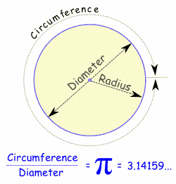
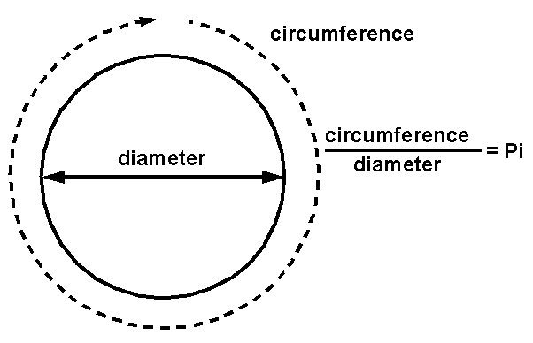
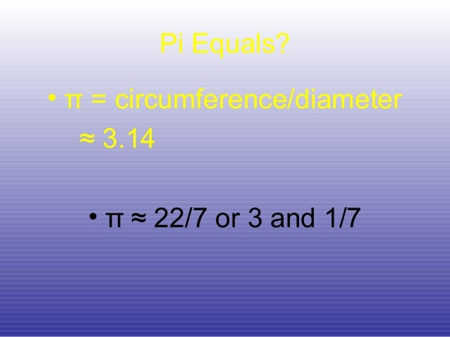
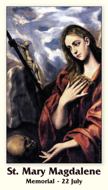
La razon de la circunferencia y el diametro es obvio que es el numero PI.
22/7=DIA DE MARIA LA MAGDALENA=3.14 =PI

SABIDURIA=SABADO=LETRA S=$
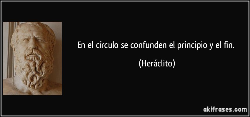
EN EL CIRCULO SE CONFUNDEN EL PRINCIPIO Y EL FIN- HERACLITO
y la Omega, principio y fin, dice el Señor, el que es y que era y que ha de venir, el Todopoderoso.
16. Apocalipsis 1:11 que decía: Yo soy el ALFA y la Omega, el primero y el último. Escribe en un libro lo que ves, y envíalo a las siete iglesias que están en Asia: a Efeso, Esmirna, Pérgamo, Tiatira, Sardis, Filadelfia y Laodicea.
17. Apocalipsis 2:27 y las regirá con vara de hierro, y serán quebradas como vaso de ALFArero; como yo también la he recibido de mi Padre;
18. Apocalipsis 21:6 Y me dijo: Hecho está. Yo soy el ALFA y la Omega, el principio y el fin. Al que tuviere sed, yo le daré gratuitamente de la fuente del agua de la vida.
19. Apocalipsis 22:13 Yo soy el ALFA y la Omega, el principio y el fin, el primero y el último.
|
|
|
|
|
 First
Previous
2 a 14 de 29
Next
First
Previous
2 a 14 de 29
Next Last
Last
|
|
| |
|
|
©2026 - Gabitos - All rights reserved | |
|
|

.jpg)