|
|
RELACION DEL CUBO/METATRON CON EL NUMERO 19
Metatron's Cube
|
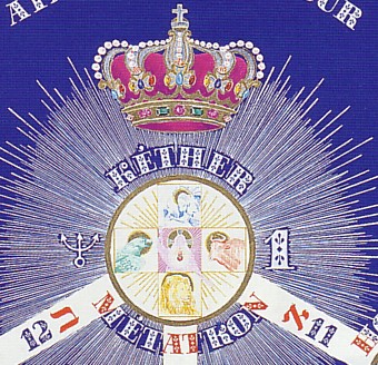
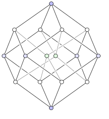
Metatron's Cube is usually presented as thirteen circles and the lines that connect the middles of those. When you look at this image, the eye is first presented with hexagons and hexagrams; then with triangles and rectangles.
Note that the figure depicts the "six directions in space" (3 dark lines), and is essentially an expansion (by adding six circles) of the Star of David, located at the center. Note especially that the Star of David consists of seven points, although the center point is seldom emphasized. The Cube is a depiction of 12 around 1 like the disciples or the 12 tribes, the labors of Hercules and the zodiac signs.

The Cube is easier to see if we fill in six more circles. Note that adding the Pythagorean "Y" to the hexagon yields three rhombus, which is how we depict a 3D cube in two dimensional drawings. Studying this cube is a lesson in perspective drawing.

Overlapping the circles (so that the center of one is on the circumference of another) and making them opaque, yields this figure; the cube of three, composed of 27 spheres, 8 of which (2 cubed) are hidden, leaving 19 visible. This means that the cube of two is hidden with in the cube of three, just as the cube of 1 is hidden in the cube of 2. The cube of 4 conceals the cube of three.

Making the spheres transpart yields the figure known as "the flower of life", composed of vesicas. Note how you can see the "hidden" spheres, and how the center circle represents three different spheres; one at the front corner, one at the opposite corner and one in the middle of the cube.

The cube of 13 circles is an abbreviation of, or short-hand for, the cube with 27 spheres.
|
NUMERO 19/DAN/OPHIUCO/ JUSTICIA/ $$$ / SCORPION / SOPHIA/ SABIDURIA / NUMERO DE ORO PHI/ PUERTA DE ORO
|
|
|
|
|
Metatron's Cube
|
Here is a recent aerial photo to use for reference.

This image marks the major landmarks in the DC map layout.

In these images, it is easy to see both the pentagram and New Hampshire Avenue touching two points of that. The pentagram alone accounts for 6 of the eleven points of the Tree of Life; spheres 2-6, as well as Daath located at Scott Circle, north of the White House, where the diagonals of the pentagram cross. The other points are Logan Circle, DuPont Cr, Washington Cr, Mt Vernon Square, and the White House, all of which fall right where they need to be on the tree/cube.
Six of the points lie on or adjacent to the 16th Street axis, the House of the Temple at the top, on the east side of the street, Scott Circle where the diagonals of the pentagram cross, north of the White House, the White House, the Washington Monument which was located 371 feet east of the axis due to marshy ground at the axis, and the Jefferson Memorial, also on the axis.
That's all but two of eleven (including Daath) accounted for by the axis and the pentagram. The only ones missing at the Archives and the Medical Center.
Note how NH Ave (in yellow below) is directed at the Custis-Lee Mansion in Arlington, the location of the National Cemetery. [Robert E. Lee, who married a descendent of Mary Custis (George Washington's wife, who inherited the land), was the last private owner of the property.] As you can see, a line from that point back toward the city (in purple) passes through the Lincoln Memorial (circled in purple) and is directed to the Ellipse, south of the White House. This line is parallel to the other sets of purple lines that connect points on the pentagram.
The streets were numbered beginning at the Capitol Building (in the green rectangle), so the blue axiis at 8th Street, 16th Street, etc., effectively quarter the city east and west. Rememeber that the two versions of the cube have 13 and 19 circles, and note that Logan and DuPont Circles (at the top corners of the pentaram) are located on the 13th and 19th Street axiis (in orange below), half way between the blue axiis. 32nd Street is in Georgetown.
As noted above, the 16th Street axis, provides the location of six of spheres on the tree. In the image below we see the Scottish Rites House of the Temple (at the top) and the Jefferson Memorial (at the bottom) circled in blue. The White House is marked by a red square.
The National Archives Building (circled in blue) lies half way between the White House and the Capitol, where PA (in green) crosses the blue axis. The Navy Medical and Surgical Center is sligthly offset from the axis on the west side. Extending PA to the NW past the WH, locates the corner of the large rectangle opposite to the Capitol, at Georgetown where the avenue cross the blue axis there.

The reason that I have painted the Capitol and two of the streets a differnt color (green) will become apparent when you look at the following image which illustrates the fact that Penn Ave has been constructed in three different sections. In order for the avenue to run straight all the way from Georgetown to the East Branch, the CB would have been located to the south a bit.

The topographic image below shows us why the Capitol was located where it was. The spot on the blue axis that would have provided a straight avenue, was located on the side of a steep hill. The building was simply moved due north to the next best location on that line.

If you look at the pair of lines coming from the west side of the CB (segments of Penn and Maryland Ave's) you will see that they are symmetrical to one another. This means that both of these streets were shifted when the CB was displaced; which also relocated the Jeff Mml (circled in green) at the SW end of Maryland Ave.
This means that if the CB had been placed further south, Penn Avenue would have been straight (meaning a diff angle), which would have changed the angle of Maryland Ave, thereby relocating the Jeff Mml and the National Archives Bldg (in the green square) on PA between the CB and WH. If you go back a page and look at the hexagon in the map, you see that the bottom of that figure is distorted; and that is because the CB and Jeff Mml are displaced.

Moving the CB would also put it in the correct spot in relationship to the corners of the rectangle, which we see re-drawn (in purple) above. This shows the CB and Georgetown at two corners, and the opposite, un-marked corners, as well as Scott Circle in the pentagram in the middle of the top side of the rectangle, and the Wash Mmt, which would lie north of the bottom line of the new figure.
|
|
|
|
|
|
Metatron's Cube
|
Here we see an idealized verion of the shortened, 13 circle Metatron's Cube, superimposed on the DC map. The three axiis that determine the six directions in space (black lines) are provided by 16th Street, Pennsylvania and New York Avenues. You can see how the displacement of the Capitol Building has resulted in the mis-alignment of Penn Ave, which moved the Archives Building (on PA between the CB and WH), the Wash Mmt, the Lincoln Mml, and the Jeff Mml.

Note that, while the Lincoln Mml does lie in line with the axis at 23rd Street, as well as the line from the CB running through the Wash Mmnt, it does not correlate to a feature on the tree/cube. It is the largest monument which does not fit, and derives from the McMillan Plan of 1901. As I point out elsewhere, several elements of the 1901 plan were never adopted, and those responsible for that plan, appear not to have been part of the inner circle of planners who are in control recently. The placement of the LM emphasizes that fact.
This image shows an overlay of the shortened version of Metatron's Cube (with ellipses rather than circles) onto the DC map. The thirteen ellipses have been numbered beginning at the center and then moving clockwise from the top, two times round. The idea here is to show how closely the monuments are to the centers of these ellipse making up the cube.
The WH at 1 is located at the exact center of it's ellipse, as is Scott Circle at 2, Mt Vernon Square at 3, and Washington Circle at 7. These are the four corners of the rhombus formed by the overlap of the pentagon and the hexagon. The HOT at the top at 8, is located low, actually at the bottom edge of it's ellipse (where it touches sphere 2).
The NW corner of the blue hexagon falls in the middle of Georgetown at 13, while the opposite corner falls on an intersection in the middle of ellipse 9. This point is directly north of the CB and east of Scott Circle.

The SW corner at 12 is not marked by a landmark that I know of yet. The Medical and Surgical Center is just offset from the center of 6. The Wash Mmt is north and east of the center of 5. The Archive Building is at the center of 4.
Since the position of the Jeff Mml at 11, was tied to the pos of the CB at 10, and since the CB was moved to the north a little bit, both of these lie north of their centers.
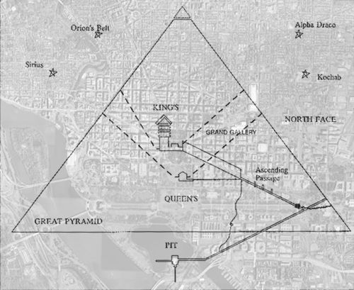
My assertion is that the planners utilized Metatron's Cube as a template for the map, but before doing so, they reduced it in height so that the triangle which had been equilateral, now has base angles of 52 degrees, like the cross-section of the Great Pyramid, and I hope that I have proven my point.
|
|
|
|
|
|
Metatron's Cube
|
Yggdrasil
This image is entitled "The Nine Worlds of the Odinic Mysteries", and is taken from Manley P. Hall's book "Secret Teachings of All Times". This is the basic shape of Yggdrasil, the Nordic version of the Tree of Life.
Note that this image differs from the Hebrew Tree of Life in two ways; one is that the Hebrew tree has ten spheres, and the other is that the sun lies at the center of the Hebrew tree, instead of the earth. Here the sun instead of the Throne of God, as the goal of the spirit, is placed at the top of the tree, somewhat like a star atop a Christmas Tree.

Yggdrasil is a geocentric (earth centered) view of things, while the Kabbalistic tree is heliocentric (centered on the sun). This figure is essentially the six directions in space imagery, the Cartesian coordinate grid, where the four outer spheres of the cube (the Big Rectangle) have been replaced by the directions, N,S,E and W, and space has been depicted as curved rather than square. The Templar Cross is the 2D version, an abbreviation, of this image.
Remember that previously we have discussed two versions of the tree that resulted from altering the original (13 circle) cube image. One of those was based on a dodecahedron with overlapping pentagon and hexagon, and the other on a double cube (1x1x2) with overlapping circles and hexagons. The changes in the cube image were necessitated by a move from nine to ten spheres, and were accomplished by splitting the second sphere from the top in to two spheres, and de-emphasizing that sphere; this is called Daath, and is not depicted explicitly in the Kabbalistic tree.
Here the cube remains intact, yet has been conceptually divided into 9 and 4 spheres. According to Hall, the number 9 relates to chambers used for initiation practices by both the Norse and Greeks:
"The Nordic Mysteries were given in nine chambers or caverns, the candidate advancing through them in sequential order. These chambers of initiation represented the nine spheres into which the Drottars divided the Universe. There is undoubtably a relationship between the nine worlds of the Scandinavians and the nine spheres, or planes, through which the initiates of the Eleusian Mysteries passed in their ritual of regeneration."
Enoch
According to tradition, Metatron is seen as the entity who transmitted Kaballistic knowledge to man (in the same manner as Mercury, Apollo and Isis are said to have given man Mathematics, writing, etc). In Kabbalistic stories, Enoch is said to have become the Archangel Metatron after ascending to the Throne of God. Note that the notion of Enoch living 365 years before being taken, marks him as a solar figure.
"And Enoch lived sixty and five years, and begat Methuselah: And Enoch walked with God after he begat Methuselah three hundred years, and begat sons and daughters: And all the days of Enoch were three hundred sixty and five years: And Enoch walked with God: and he was not; for God took him." KJV Genesis 5:21-24
By faith Enoch was taken away so that he did not see death, "and was not found, because God had taken him"; for before he was taken he had this testimony, that he pleased God. Hebrews 11:5
Loss, Recovery and Preservation
Encoh is associated with the transmission and preservation of Knowledge. Recall that, in the Bible, it was Enoch who was responsible for constructing the two pillars of brick and stone that were intended to preserve human knowledge, which had remained an oral tradition since the time of Adam, thru the Flood. This notion ties in with the legend that Enoch invented writitng.
The legend of Enoch is commemorated by Scottish Rite Masonry in the Royal Arch Degree, a Jewish degree based on Kabbalistic philosophy. It is the 13th degree and called the Royal Arch of Enoch, or the Master of the Ninth Arch.
Enoch is said to have "received" the True Name of God in a vision, and with the help of his son Methuselah, to have excavated nine apartments or chambers in the earth in Canaan, one below the other, and each with a supporting arch. In the lowest, or ninth, he placed a CUBE of agate with a triangular plate of gold with the Ineffable Name engraved on it and sunk into one face of the cube.
Recalling that Enoch's name signified in the Hebrew, INITIATE or INITIATOR, it appears clear that the Enoch legend refers to both a place of initiation, nine chambers in the earth, analagous to the Odinic and Eleusian Mysteries, and to a Secret Tradition concealed there in. The term excavation is used in allegories to indicate study and meditation, as in "the Templars were excavating below the Temple".
A Cube and a Triangle
As the story goes, when Solomon began surveying for his Temple, workmen "discovered" the opening to the vaults; in which were discovered the cube of agate into the surface of which he had placed a triangular plate of gold emblazoned with the Name of God.
[The Kircher tree features a pair of circles and hex/cubes like a vesica, while the a-shaped tree uses overlapping pent and hexagons symbolizing the macrocosm and the microcosm (above and below), the enoch story juxtaposes triangles and squares or cubes.]
Concerning the hexagon/cube, we hear from Albert Pike (p 827; Morals and Dogma): "The hexagon faintly images to us a cube, not visible at first glance, and therefore a fit emblem in faith in things invisible....reminding you of the cubical stone deposited by Enoch". This reminds us of Metatron's Cube, which is composed of hexagons, and of how the cube of 2 remains hidden in the cube of three formed by M's Cube, and the One (at the center of it all) that is contained within that.
In Henry Calusen's "Commentaries on Morals and Dogma" (page 72) we read:
"Secrets are hidden from all but a discerning few and are revealed only through fuller and deeper study. For example, in ancient mythology a square is the symbol of the material principle; a cube, the symbol of the material man (and universe). A triangle is the symbol of Deity and by association of all things divine and of the spiritual. Hence a triangle within a square, or upon the face of a cube which appears similar, symbolizes the divine within the material."
This, of course refers to the Gnostic and Hasidic notion of the divine spark, and the alchemical notion of gold in basic matter.
Then from Pike again (Morals and Dogma; p 209):
"The Holy of Holies of the Temple formed a cube..four represented Nature..three represented the Supreme Being...the name of the Deity engraved on a triangular plate and sunken into a cube of agate..teaches us that the true knowledge of God is written by him upon the leaves of the great Book of Universal Nature... This knowledge of God, so written there...is the Master Mason's Word."
Metatron = Enoch
Look again at cube, and note the triangle on and "within" the cube, and recall what Clausen said about that. It is my contention that the story of Metatron's Cube, and the Cube of Enoch are the same. Note how the earth at the bottom, is outside the triangle, and remember the notion of the Shekinah, the "divine presence", being an exiled Bride.

Plato correlated the cube to the element of earth and the dodecahedron to the whole of the Universe. Metatron's Cube is intimately related to both these figures. While the square and cube have material connotations, the triangle symbolizes things spiritual. The Royal Arch legend juxtaposes a cube and a triangle, which was golden with the Name of God inscribed on it.
The A-shaped "Portae Lucis" (Gates of Light) version of the Tree of Life, which depicts the emanation of the Many from the One, fits the triangle form within Metatron's Cube. If we add the numerical values for the letters in the name Jehovah (J=10, H=5, V=6 H=5) we get 26. If we add the values of the spheres up the middle of the tree (the straight way) we get 10+9+6+1 or 26 again. Here is that name graphically. God man man in his own image.

The A-shaped tree utilizes the symbolism of an overlapping pentagon and hexagon to illustrate the hermetic notion of the analogy between the macrocosm and the microcosm. Extending the sides of the hexagon inside the tree image, points to top corners of the pentagon.

If you do this in all three axiis of the triangle, you are presented with a figure that maps to the front 3 faces of the dodecahedron. The upright yellow triangle below marks the centers of these 3 faces. The three small yellow triangles above, point to the three faces that are just out of view, while the other three outer circles match faces that are turned to us. The upside down orange triangle indicates the centers of the three faces on the far side.
All of the elements of the cube, except for 2, also fit the DC landcape.

The Kircher tree does not work here, or in the DC map. The city planners seem to favor this version of the tree. I hope that this helps to show that there was more to the pentagram in the map than a goat's head.
|
|
|
|
|
|
Metatron's Cube
|
After showing that the A-shaped Tree of Life relates to Metatron's Cube, and how both the tree and cube map to the dodecahedron and the DC map, the intention here is to present a mental exercise where we imagine the DC ladscape overlaid on to a stellated dodecahedron, just like the tree and cube.
This image from earlier shows how the dodecahedron relates to a 3D depiction of a cube, and how the Tree of Life maps to points on the dodecahedron. It also illustrates how the 13 circles in Metatron's Cube relate to the corner and faces of the dodecahedron. Three of the outer circles map to faces that we can see, three others to faces turned slightly away from us.

Three of the inner circles map to the three faces on this side, while the other three correlate to three faces (turned upside down) on the opposite side. These last three are all marked by features in the map relating to G Washington; Washington Circle, Mt Vernon Square and the Wash Mmt (5,4 and 9).
The image below is what's called a stellated dodecahedron, where the points in the centers of the faces are raised so that a straight line connects them. Compare this figure with the grey Metatron's Cube above. This image results from bringing 5 equilateral triangles together at a point.
Notice how when the edges of the pentagons meet, 2 of these equilateral triangles form a flat plane, and the line between the new middles of the faces (in blue below) bisects the line formed where two faces meet, creating the same rhombus figure that is generated by the vesica. 5 of these rhombus figures meet at the center of each pentagon here. Just as elsewhere, three of these rhombus depict a 3D cube (in blue above).

This image shows the overlapping pentagon and hexagon/cube on both the map and deodecahedron. These account for 9 of the eleven points in the tree figure.
The Wash Mmt is at the bottom of the hexagon
The WH, which is at the corner of the dodeachedron, is at the bottom of the pentagon
Scott Circle is at the top of the hexagon, in the middle of a pentagonal face
Wash Cr, MtV Sq, and the WM (all affiliated with GW) all lie at points where 3 faces meet (at corners of pentagons).
The triangle at the top of the map figure is one of the five triangles making up a stellated face, so the top is at the center of a face.
The Jefferson Memorial, at the bottom of the tree, falls on the center of a face
The other two corners of the hexagon, the Archives Bldg and the Med Ctr, both lie in the middle of a face, like Scott Cr (accounting for 5 of 12 faces, so far).
The illusion of the hex/cube derives from a series of lines that connect a pentagon corner to a center, then that center to another corner, and to another center, etc. Rememeber that the CB and Jeff Mml are located north of where they should be.

The sides of a dodecahedron come together in threes just like a cube does, but it forms a different solid since it has different angles and number of sides on it's faces. When you view these next images, remember that we are attempting to lay the map on a dodecahedron like a rubber sheet. Note what was said before about finding the corners of pentagons by extending the sides of hexagons.
As you can see, extending P and NY Aves (in purple) indicate the directions to 4 other centers of faces (peaks on the dodecahedron). These are the corners of the Big Rectangle in Metatron's Cube. NY, Penn Ave and 16th Street mark the x, y and z axis in the cube map. Two of the corners are marked by the CB and Georgetown, at opposite ends of PA.

The position of the NE corner is determined by running a line north of the CB, and extending NY Avenue. These meet in the same place where N Street (which runs through the middle of Scott Circle) crosses there. Running west, N Street marks the NW corner where it crosses PA in G'town. The southwest corner can be found by extending NYA to the SW, but no landmark exists there.
The centers of four faces correlate to the four corners above, three more to the front faces in red, and two more the point at the top and the Jeff Mml at the bottom of the tree; that's nine of the 12 faces. The red circles correlate to the centers of three faces on the opposite side of the dodecahedron. I suspect that extension of PA past the Capitol and the section of DC east of the CB, wraps around the figure, but I have not worked that out yet.
DC Symbols Homepage
|
|
|
|
|
|
From Pentagram to Pyramids:

Masonic and Kabbalistic Symbols
in the Washington, D.C. Map
As there is a lot of material contained here, I have posted a list of my DC Symbols webpages and related videos. I will be putting new pages/sections at the top of that listing. I conceptually divide the material into a historical area, an area about geometric design principles, and an area about Masonry and the Kabbalah. But, as these inter-relate in the DC map story, it is hard to separate the three.
"Into whatsoever city or town ye shall enter, inquire who in it is worthy; and there abide till ye go thence. And when ye come into an house, salute it. And if the house be worthy, let your peace come upon it: but if it be not worthy, let your peace return to you. And whosoever shall not receive you, nor hear your words, when ye depart out of that house or city, shake off the dust of your feet." Matt.10
Please note that if you are offended by critique, satire or ridicule, you might want to turn back now, as critique is half of what I do. The same holds true if you are not a reader. You will, I hope forgive any typos and the fact that this page repeats in places, as this has been put together over a period of 17 years now.
54 Degrees, Not 52 Degrees.
I have posted a pair of Utube videos that contain a very slight revision of my 1999 thesis about the Washington, D.C. map template. This is being posted as two parts because there are so many images in them and due to time restraints on Utube videos. Earlier, I had measured the angle created by New Hampshire Avenue in the map, and had found it to be 53 + degrees, which is larger than the ~52 degrees of the Great Pyramid base angle, which I saw as one template for the map. For a long time, I was unable to resolve this discrepancy. I even considered that the images that I was measuring on my computer screen were not at the correct 'aspect ratio', so I decided to reserve judgement until later.

Re-reading "Secrets of the Great Pyramid" (P. Tompkins), I was reminded that the base line casing stones of the GP (seen above) were not discovered until 1836. That is, in 1791-2, the DC planners had no accurate information about the base angles. Jim Alison measured the map at 54 degrees, and associated that with the 36-54-90 'mr' triangle from ancient Egypt, which was seen as a building block of the cosmos. It is now my opinion that both the mr triangle and the GP were used as templates for the map. So were Metatron's Cube and the Tree of Life. Those two were shortened until the equilateral triangle was 80% of it's height.

I suggest that the planners thought, in 1791-2, that the GP had 54 degree base angles to match the pentagon. Note that Sandusky , Ohio has a 54 degree triangle included in its map plan. If you inscribe a pentagon in a circle, and draw lines from the center of the circle to each of the points, you generate five triangles. Each triangle has a 72 degree angle at the center of the circle and two base angles of 54 degrees. New Hampshire Avenue forms the left side of one of these triangles in the DC map.
The Utube videos are called "The Washington, D.C. Map and the 36-54-90 Triangle: Introduction and Part 2.
Masonic-friendly
I contend that this website represents the first original, comprehensive, and Masonic-friendly examination of the subject of Symbolisms Embedded in the District of Columbia Map Layout.
It is original in the sense that what I present here concerning templates that were used for the Washington, D.C. map are My Own Ideas (first posted online in 2001), and is comprehensive in that I have made an attempt to cover all the bases so to speak, from history to astronomy and architectural design principles - including dealing with the huge amount of Misinformation about the ongoing DC planning project that is being broadcast without regard to the Truth, mainly across the internet by anti-Masonic individuals , although some book authors are guilty as well.
I would like to point out that I was originally inspired to write and post online comments about the DC map, after seeing things on the internet that were intended to make Masons look bad based on what was supposedly going on in the map. After that I continued to write and post about things that I saw that came from book writers/sellers, who just can't seem to get their facts straight.
Facts and Fiction
For instance, on page 1 of "The Magic of Obelisks", Peter Tompkins calls George Washington 'a thirty-third degree Mason'. Now, any one who knows anything at all about Masonry knows that the group with 33 degrees is the Scotish Rites, and they didn't even institute the 33 degree system until after George Washington died. Also, in his book "Solomon's Builders", Mason Christopher Hodap suggested that there we 10,000 lots up for sale in the City of Washington. However, if you look at a map that shows lot numbers, you actually find just over 1000. Later Hodap recommends that the new city was being started from 'scratch' and the area where it was located was 'wilderness', as if no one had ever been there before.
The truth is that George Washington's home, Mt. Vernon, was just a few miles straight down the Potomac from the eventual White House location, and his wife, Martha Custis Washington, owed 900 acres that is now the Arlington Cemetery. Please see this webpage, and see the maps that depict the properties in the area before 1791. Near the bottom of the page, you can see that small towns of Hamburg and Carrollsburg lay within the area encompassed by the new city. Figure 4 on that page, shows the Hawkins topo map of the area that clearly depict a road that ran from Georgetown past the White House location and south of the Capitol location, to the ferry on the East Branch of the Potomac, which served as the basis for Pennsylvania Avenue.
Then there is the story about the Ellicott Brothers having made 'revisions' to L'Enfant's map, including eliminating diagonal streets and straightening Massachusetts Avenue. If you read about the history of the map, you will find that L'Enfant presented drawing to Washington, three different times, in the spring of 1791, in June of 1791 and in August of 1791. The August drawing is in the Library of Congress, accompanied by a letter to George Washington, and it shows Mass Ave to have been 'straightened' by L'Enfant himself, not by the Ellicotts. And none of this came from anti-Masons!!
I recently completed reading a 2007 book entitled "Grand Avenues" written by Scott W. Berg. Berg has a website but there isn't any useful information there. Note the section called 'Facts and Fiction', where you read only "Coming Soon".
I will have to say that I like Berg's treatment of the planning of the map much better than I do Bob Arnebeck's in his book "Through a Fiery Trial", his book is STILL full of the tired old fictions about DC. The most common of those being that the White House and the Capitol Building were located on the two highest points in the area. To prove that is not true, you need only go to the Library of Congress Map Collection, click on search by Keyword and enter "Washington DC Hawkins". You will be led to a drawing entitled, "Topography of the federal city, 1791 : [Washington D.C.] / by Don A. Hawkins, Washington, D.C.".
You can search the image and prove that there are locations near both the WH and the CB location which are higher than both of those are. Another fictional statement in Berg's book can be found on page 185, where he states categorically that "The only known copy of a plan for the federal city in L'Enfant's own hand" is referred to as the manuscript plan. If you go back the the search option at the LOC Map Collection, you can now enter "Washington DC L'Enfant", and change to 'Gallery View' after you click.
There you find, not one but several versions of the manuscript plan, plus another map by L"Enfant. The OTHER map is labeled "[Dotted line map of Washington, D.C., 1791, before Aug. 19th]". That is the map that contains the revisions to the manuscript plan that George Washington requested that he make in June 1791. The dotted line map proves that L'Enfant was the one who straightened Massachusetts Avenus, and not Ellicott. Beware of what you find in these books about planning Washington, D.C., as they were written by book sellers.
Anti-Masonic Forces
Perhaps the saddest and most pitiful players in this story, are those who try to make themselves out to be the 'good guys', while trying to make Masons out to be the 'bad guys'. Unfortunately for their self esteem, they never really study Masonry, and as a result have no REAL understanding of the symbolisms involved, and they have to result to lying to do that. My two unfavorite examples of that are connected to the number 666, which every one knows is 'bad' or evil. The first is a popular notion with people who never took the time to look at the map, like Christopher Hodap, who proclaimed that there were 10,000 lots in DC. The idea that was presented was that the Capitol was placed on lot number 666 for occult reason (cue the scary music). Any one who has read about the history of DC knows that only lots that were to be sold were numbered, so that is a lie, pure and simple. A perfect example of the good guys resorting to bad behavior to try and make their supposed opponents look badder.
Another 66 story, involves the idea that the Washington Monument is 555 feet tall, but that it has a base that goes 111 feet into the ground to make it actually 666 feet tall. The story goes on to suggest that Egyptians buried their obelisks in the ground for stability too. The problem is that the Egyptians balanced theirs on the end above the ground like you see in New York and at the Vatican. The monument is NOT 11 feet in the ground. That is another lie made up to make some one else look bad. Guess who it makes look bad to me??
People Say and Write the Silliest Things
As you can well imagine, in the 15 + years that I have been studying the Washington D.C. map layout, I have read some of the silliest things that you have ever heard in your life, all designed to negate the idea that the city planners put in place a system of Masonic Symbolism in the map. I suggest that if you read this whole page, it will become apparent to you that people who make those comments have never looked closely at the map, as I have.
The comments range from casual comments like, "Oh, you could probably find geometric shapes in the maps of any city that you look at" (from Dan Brown), to supposedly serious comments from people like Robert Hieronimus, who suggests that he 'made his own drawings' of the pentagram. Of course, there is no need to ever do that will zillions of copies of the map available to us.
Look at the image at the top of the page and note that a pentagram is composed of five lines that cross and form a total of 15 segments. In the map ONE of those is missing. Robert tells us that he made his own drawings and found that the map pentagram 'doesn't have ANY legs'; which is stupid. You can easily see that the intention was to represent a pentagram and that New Hampshire Avenues represents one side of an equilateral triangle with 52 degree base angles like the Great Pyramid. The right side of the triangle doesn't have to be filled in for you to see that.
The more you look the more figures you see, like rhombus and hexagrams etc. But you have to look, rather than just talking about it in a discussion group with others who never studied geometry or surveying. He is my most recent favorite comment which I have received from a Mason, who seem to feel that being a card carrying member makes them better qualified to divine what is going on in the map (without studying it) than others (who don't study it).
"We DC Masons argue back and forth whether there is any intentional Masonic symbolism in the District's layout. One thing we tend to agree on, whether we're on the yay or nay side, is that no one knows just what the hell the founding fathers would have inlaid them on the DC map for. Cubes, pentagrams, lines this, and lines that ... and?"
No one knows? That is just silliness, as I said. I have studied the map long and hard, and I contend that I know as much as any one alive today 'what the hell the founding fathers' put in the map. I welcome you to read closely and see what you think. You will notice that people who make comments like the above do not have extensive web site or videos covering the subject matter.
Try This
Watch the animation at the top of the page until you get a feel for the grid pattern that forms the basis of the Washington, D.C. map. See how the grid develops out of the lines which connect the points of the inverted pentagram. Now cut a narrow strip of paper and tie it into an overhand knot and notice the pattern that it makes.

Compare the lines in the form that results to the lines in the DC map grid, and pay particular attention to the pentagram that is formed.

If you were able to tie a strip of paper five times, you would find that it would create a larger pentagram as seen below.

Here is another image, in case you might have trouble seeing the pentagram that some people can't see.

Hopefully you can see that this is pure geometry and that Satanism was not involved in this demonstration in any way. If you either can't see the pentagrams or you believe that Satan rules certain geometric forms in God's Creation, you might not want to continue past this point.
A Surveyor Looks at the Washington DC Planing Map
When I was first introduced to the idea that there were symbols embedded in the Washington, D.C. landscape I was working as a carpenter. It didn't take long for me to figure out that if I really wanted to understand the processes that were involved in the design and layout of the city, I would need to work with surveyors. When ever you read a history of D.C. you are continually reminded that Washington, Jefferson and Ellicott were all master surveyors. When you read modern attempts to account for the features and structures that we see in the map, it is painfully apparent that none of them have been written by people with surveying backgrounds.
The thesis that I present here is that the map plan was based on a rhombus grid that develops from extending the lines of the pentagram located north of the White House. In the design world, this method is called 'polygonal projection', because you are projecting lines of a polygon (a rhombus). If you know anything about geometry, you know that a rhombus is derived from a vesica; and that it is composed of two isosceles triangles. In the animation at the top of the page, you see that the map grid results from extending the lines of the rhombus north of the WH.
The second part of my thesis is that the Capitol Building was 'dis-placed' from its ideal location since that fell on the steep side of Jenkins Heights. I suggest that the CB is about 600 feet north of where it should be to fit the rhombus grid. A line connecting the points on the right side of the pentagram show the displacement, and indicate the ideal CB location on a straightened Pennsylvania Avenue.
When you read David Ovason's book "Secret Architecture of Our Nation's Capital", you see that he suggests that the map designed centered on the right triangle that has the CB and the WH at two of its corners. On page 349 he writes that:
"Either Ellicott or L'Enfant drew a line from the top of a wooded hillside, and directed it toward a specific point of sunset. From this single line, the planner subtended another which ran due west from the hill. At a certain point along the second line, he drew across it, at right angles. a third. He extended this, so that it cut the first line - the sunset line. In this way, he formed a triangle on the earth."
In his version of the story, the first line to be surveyed ran from the future location of the Capitol to the future location of the White House. Then a second line was drawn due west. Then a third north-south line was drawn from the WH location. If you look at the map, you can see that the 'first line' does not match the rhombus grid of the upper parts of the map. That means that he has you beginning a survey with the mis-matched part of the map, rather than with the 'regular' part that surrounds the WH.
It also means that he makes no attempt to account for tying the survey down in any way. When you do a survey, you like to 'tie it down' by locating some adjacent know location as a reference base point. If you study the history of the survey of the Mason-Dixon line, you find that it was tied down to three different points. I suggest that the DC map is tied down to a point where Pennsylvania Avenues and N Street meet in Georgetown; and that the 'base line' for the survey was the section of Penn. Ave, between there and the WH. location. If you extend that line to the East Branch of the Potomac, you see that it points to the place where Penn. Ave. is directed today. If the CB were 600 feet south, PA would be straight all the way.
A third part of my thesis about the map grid shows that in the 20th century, elements were placed in the map, like the Pentagon Building, which were once again in line with the bearings established in the original rhombus grid. The 'front' of the Pentagon is directed, not toward the actual location of the CB, but toward its ideal location. In addition to that, the designers included a cross-section image of the Great Pyramid in the plan. Instead of an equilateral triangle, New Hampshire Avenue forms a 52 degree angle like the base angle of the pyramid.
I have added a section called "A Surveyor Looks at the Washington, DC Map". I recommend that you read that section with "A Geometer's DC Notebook" and "Washington DC's Isometric Map Grid".

You can see a series of videos entitled "A Surveyor Looks at the Washington DC Map", at my Youtube channel. Here are links to Part 1, 2, 3, 4, 5, and Part 6.
I have added a section that is a look at the symbols in and related to the legend of The Judgement of Paris, and a comparison of those symbols to elements contained in Dan Brown's book The DaVinci Code. The suggestion that is made is that the elements in Brown's book mainly derive from that legend, although Brown never mentions it in the book.
If you have read Brown's book, you know 1) that it opens in Paris, 2) that you are quickly introduced to the symbol of a pentagram within a circle which he ties to the goddess Venus by virtue of the orbit of the planet Venus, and 3) that the code word in the middle of the book turns out to be 'apple' which he connects to the Biblical figure Eve. If you look at the story of the Garden of Eden in the book of Genesis, you find that the word apple does not appear there; the word that is used is 'fruit'.
The story of the Judgement of Paris, is the story of how the Trojan War got started. A golden apple with the words "For the Fairest" is thrown into a wedding party at Mount Olympus which, of course, disrupts the party. In the story, Paris, from Troy, is asked to judge a beauty contest among three goddesses, and he ends up giving the apple to Venus. As to the connection to the pentagram, you find that figure displayed if you cut an apple in half cross-wise. That means that the key elements of Brown's book are presented in the story in a simplified manner since Paris gives Venus the apple.
Sky Watching in Washington, D.C. -
An Astronomer Looks at the Washington DC Map
If you are in DC the first week of May, you can go to the west side of the Capitol Building at sunset and looked toward the White House to see the sun. The image above shows the sun setting May the first, 20 degrees north of due west in DC. This event is the flip side of the story told by David Ovason about the sun setting over Penn Avenue in August, which you can see in the image below. Here you can see that the sun also sets there in May. Now, re-read his book where he talks about Pennsylvania Ave having been aligned to one sunset on one day.

If you are in DC the second week of November, you can stand on the west side of the CB to watch the sunset near the Jefferson Memorial to the left of the Wash Mmt. If you were there in February, the sun will be setting in the same place again after having made its southerly most pass in December. David Ovason never mentions that Maryland and Penn Aves are symmetrical to one another.

Penn Ave is NOT aligned to one sunset, but to two of them, just as Maryland Ave is!!
From page 339 Secret Architecture, "Both L'Enfant and Ellicott would have insisted that only one day (which is to say, one particular sunset) would mark precisely the orientation between the Capitol and the President's House." Parentheses are his.
I remind Serious Students that these dates, early Feb, May, Aug and November correspond to what are known as the 'cross-quarter' days - the days half-way between the solstices and the equinoxes. In the northern hemisphere the cold peaks statistically on about Feb 6th, while the heat of the summer peak about Aug 6th. The mid-points are in May and November.
Students of astrology should note that the solstice and equinoxes happen on the cusp (beginning) of the cardinal signs, Aries, Cancer, Libra and Capricorn. The cross-quarter days occur at 15 degrees of the fixed signs, Taurus, Leo, Scorpio and Aquarius, 45+ days after the equinoxes and the solstices. If you know your zodiac symbolism you will recognize these four as relating to the four creatures which were depicted in Ezekiel and Revelation as - a bull, a lion, a man and an eagle. Here is a standard Royal Arch image used by Masons that bears the same creatures.
If you were to watch the sunset for a year from the west side of the Capitol, you would see the sun set in front of you in March and September, it would set on Penn Ave in May, it would set 31 degrees north of due west in late June, and on PA again in August - as Ovason points out.
Next you would see the sun set over Maryland Ave in November, it will set 31 degrees south of due west in Dec and over MA again in Feb. Instead of being oriented to one sunset on one day, the city appears to have been oriented to four sunsets on four days, as seen by Penn and Maryland Aves. The city is not aligned to the solstices but to the cross-quarter days; the fixed zodiac signs, not the cardinal ones.

Some of you may have seen David Icke's demonstration where he uses the image above from Charles Westrbrook's book to prove the DC streets were aligned to the solstices. Please note, first of all, that those three sets of lines are not all parallel, yet they are all labeled as a solstice alignment. (I have added the numbers on the right.)
If you study the solar arc, you will find that while the sun moves to 23.5 degrees north and south of the equator at the solstices, as seen from the equator, that arc widens as you move north or south on the globe. At the latitude of DC, the total solar arc is 62 degrees, 31 north and south. That is, the sun is located 31 degrees north of due east on June 21 in DC.
Since the sun moves 71% of the arc between the equinox and solstice in half that time (45 days), The cross quarter day sunrises and sets happen at 31 x .71, or 22 degrees from due east-west in DC. That matches the alignment of Penn and Maryland Aves.
Take a look at the DVD named "Riddles in Stone" at about 17:00, where they are discussing the star Sirius, the brightest star in the sky. When you look at the earth's orbit around the sun, you will see that on July 4th, the earth is at its far point from the sun, and it is in such a position that the sun aligns with Sirius. That means that the sun is in front of Sirius, so that you can't see it.
In the DVD, it points to the cornerstone ceremony for the Washington Monument, noting that the sun aligned with Sirius then. They fail to point out that the ceremony took place on July 4th, and that the sun aligns with Sirius then every year. Next they present an image of DC looking east -

They proclaim that on the day of the cornerstone ceremony for the monument, you would have been able to see Sirius rising in the east, and hovering over the Capitol Building as seen above. You now know that you can not see Sirius July 4th, since the sun lies directly in front of it then!! What you would have seen would have been the sun only. Sirius does not emerge from behind the sun until August, the time that David Ovason writes so much about.
Note also that in the DVD it is suggested that the pyramid was 'aligned' to Sirius; that is was built so that the light of Sirius would travel down one of the air shafts and fall on an initiate located in the Queen's Chamber. Have a look at a drawing of the Queen's Chamber and the shafts, and you can see that it is impossible for that to happen, as the southern shaft has a bend in it.
|
|
|
|
|
The Straight Line Hypothesis
revised 12/10/2006
|
While Ovason suggests that the alignment of the section of Penn Ave between the CB and the WH is purposely oriented to an August sunset, I recommend that the current position of the Capitol is not where the planners would have like for it to have been, and has nothing to do with the Virgo constellation.
"The center of the city was a viewing point, located near the western front of the Capitol Building." (Ovason page 340) Making the Capitol the center, Ovason suggests that the orientation of Pennnsylvania was determined by moving the White House to the proper location. He sees Penn Ave as a 'ray' emanating from the CB toward the WH. After determining the WH location, the position of the Washington Monument resulted from dropping a meridian line from the WH and an east line from the CB, thereby creating a right triangle.
Ovason asserts that Pennsylvania Avenue was designed in three distinct sections on purpose in order that the middle section between the White House and the Capitol would align with the sunset on a certain day. We know that the "one day, one sunset" arguement is considerably weakened because the sun sets there in May as well as in August, although he fails to mention the May date.
My arguement is that the Capitol Building is not in the position that it was meant to be in, and that the city was designed around a straight line and not a crooked one. I contend that the location that the plan dictated for the CB fell on the side of a steep hill (Jenkins Heights) and they didn't have the time to do the landscaping for that, so they moved the building due north, to it's current location.
The Ferry Road
According to the story, the commissioners asked that a 'post road' that took the easiest to build route from the Capitol to the President's House and then to Georgetown be marked on the engraved map. L'Enfant gave them Pennsylvania Avenue that, as he said, ran from the Eastern Branch to the wharves of Georgetown. Looking at the image below you can see that there was aleady an existing ferry road that connected those two places. L'Enfant just moved the end point on the river so as to straighten the avenue.

[He appears to have located the southeast end of Virginia Avenue at the 'old' ferry location. Virginia runs northwest through the location of City Hall to the Washington Monument site and Jefferson Pier.]
Topography
Today we see Penn Ave in three sections, but if we extend the top segment (Between G'town and the WH) past the White House, we see that it points to the location that L'Enfant chose on the East Branch. That is, a straight line from Georgetown to the East Branch passes through the WH location and south of the CB. The over-all alignment appears to be determined by segment 1, and not by segment 2 as Ovason suggests.
If the Capitol had been a little bit to the south the avenue would have been straight, but

The location on the line falls on a hillside, where each line is 10 feet of elevation.

What Ovason tells us has L'Enfant choosing the site for the Capitol, then positioning the White House from there so as to align with two sunsets, then presumably connecting the WH to Georgetown and the CB to the East Branch. I suggest that the avenue was designed around a straight line from Georgetown to the Eastern Branch of the river; the WH location falls on this line but the location for the CB fell on the side of a steep hill, so it was moved due north to the closest suitable location.
19.5 Degrees
The conspiracy angle on this Capitol move idea, besides Ovason's solar alignment theory, focuses on the fact that Penn and Maryland Avenues run at a 19.5 degree angle to the east-west line, meaning that in the original plan the distance between the WH and the Wash Mmt was one third of that from the WH to the CB. The sine of 19.5 degrees is .333333.
We are told that the Washington Mmt was moved 371+ feet to the east and 123+ feet south, which is also the 1:3 ratio.
Connect the dots
We can confirm this planned location of the CB with the map. Notice how Penn and New York Aves 1) mirror each other at 16th Street, 2)meet at the WH and 3)connect two corners of the pentagram. NY Ave is also a straight line.
New Hampshire Avenue connects two corners on the left side of the pentagram, as well as pointing to Arlington. If we draw a line from where New Hampshire crosses 16th Street back through the other two corners on the right side, you can see it points to the same place as above (on the straight line south of the current CB position).


Click to see large image
You can see a grid system develop from this. Even the line from Arlington through the Lincoln Mml to the Ellipse is parallel to the grid lines generated by connecting the corners of the pentagram. This grid constitutes the 'correct' part of the original map, since it is derived from either the straight line, or a mirror of it, or parallel to it. Note the twin rhombus.
Projecting N Street east and west from Scott Circle locates two corners of another rhombus where it crosses New York and Penn Ave's. These two triangulate with the Jeff Mml, completing the Star of David.

You will probably recognize this as being based on Metatron's Cube.

Below the paths on the Tree of Life follow the grid lines.

Note that the Lincoln Memorial is the largest monument that does not fit the templates.
The DC map layout accomodates an image of the Great Pyramid cross-section, Metatron's Cube and the Tree of Life, from both Egyptian and Hebrew cultures. If the CB had been located on the 'straight line', that and the Washington Monument and Jefferson Memorial would be in tune with the grid formed by the pentagram. The move of the Washington Monument made it possible for it to serve as a representation of the Queen's Chamber in the map/pyramid.
Click to see large image
Disregarding everything else that was positioned by the old CB, we look at what depends on the pentagram, presuming that segement 1 of Penn Ave is 'the straight line' which we project to the river. New York Avenue connects Mt Vernon Sq and the WH and eventually intersects with New hampshire providing the last corner of the rhombus on the west bank of the Potomac. Mass Ave parallels Penn Ave and Rhode Island Ave parallels New York, each connecting two corners of the pentagram and intersecting at Scott Circle, north of the WH on 16th.
Click to see large image
One side of the pentagon faces that point as well.

The line between the Pentagon and the 'new location' crosses 16th Street at a point the same distance from the WH as is the tip of the triangle above it. We prove this with a circle. This would be the new Jefferson Mml position, and the line is the redefined Maryland Ave.

This appears to show the White House at the center of this image.
This shows the implications for repositioning the CB. All the purple lines would be moved that radiate from there, this would move Licoln Park, The Lincoln Memorial, the Washington Monument and the Jefferson Memorial to the south, changing the street angles as well.
|
|
|
|
|
|

When molten sulphur is cooled, it solidifies into monoclinic sulphur. Sublimate of sulphur is called ‘flower of sulphur’. When sulphur is obtained by a chemical reaction as precipitate it is called ‘milk of sulphur’. These are made up of rhombic sulphur. Scientists have discovered many more allotropes of sulphur under different conditions.
All of them get transformed into rhombic sulphur at room temperature.
Sulphur has catenating power. It forms strong S-S covalent bonds. This results in formation of Sg molecules. Sg molecules have a shape of a crown like ring (Fig. 1.5). Both, rhombic and monoclinic sulphur contain S8 rings. At high temperatures smaller molecules like Sg, S4, S2, S also exist.

 |
| Rhombic sulfur and the unfinished pyramid |
 |
| Kether the Crown of the Kabbalah |
Sulfur or sulphur ( /ˈsʌlfər/ SUL-fər; see spelling below) is the chemical elementwith atomic number 16, represented by the symbol S. It is an abundant, multivalentnon-metal. At normal conditions, sulfur atoms form cyclic octatomic molecules with chemical formula S8. Elemental sulfur is a bright yellow crystalline solid. Chemically, sulfur can react as either an oxidant orreducing agent. It oxidizes most metals and several nonmetals, including carbon, which leads to its negatives charge in mostorganosulfur compounds, but it reduces several strong oxidants, such as oxygenand fluorine. /ˈsʌlfər/ SUL-fər; see spelling below) is the chemical elementwith atomic number 16, represented by the symbol S. It is an abundant, multivalentnon-metal. At normal conditions, sulfur atoms form cyclic octatomic molecules with chemical formula S8. Elemental sulfur is a bright yellow crystalline solid. Chemically, sulfur can react as either an oxidant orreducing agent. It oxidizes most metals and several nonmetals, including carbon, which leads to its negatives charge in mostorganosulfur compounds, but it reduces several strong oxidants, such as oxygenand fluorine.
In nature, sulfur can be found as the pure element and as sulfide and sulfate minerals. Elemental sulfur crystals are commonly sought after by mineral collectors for their brightly colored polyhedron shapes. Being abundant in native form, sulfur was known in ancient times, mentioned for its uses inancient Greece, China and Egypt.

 |
| St Peters Square Vatican octagonal division |
 |
| Mount temple top view |
 |
| Mount temple fron view |
 |
| Orpheus ceiling |


Honey comb


 |
| Copper sulfate crystal |
The rhombic dodecahedron forms the hull of the vertex-first projection of a tesseract to 3 dimensions. There are exactly two ways of decomposing a rhombic dodecahedron into 4 congruent parallelepipeds, giving 8 possible parallelepipeds. The 8 cells of the tesseract under this projection map precisely to these 8 parallelepipeds.
The rhombic dodecahedron forms the maximal cross-section of a 24-cell, and also forms the hull of its vertex-first parallel projection into 3 dimensions. The rhombic dodecahedron can be decomposed into 6 congruent (but non-regular) square dipyramids meeting at a single vertex in the center; these form the images of 6 pairs of the 24-cell’s octahedral cells. The remaining 12 octahedral cells project onto the faces of the rhombic dodecahedron. The non-regularity of these images are due to projective distortion; the facets of the 24-cell are regular octahedra in 4-space.
This decomposition gives an interesting method for constructing the rhombic dodecahedron: cut a cube into 6 congruent square pyramids, and attach them to the faces of a second cube. The triangular faces of each pair of adjacent pyramids lie on the same plane, and so merge into rhombuses. The 24-cell may also be constructed in an analogous way using two tesseracts.
The tesseract represents 4 th dimension and is the projection or shadow of the rhombic dodecahedron
 |
| A 3D projection of an 8-cell performing adouble rotation about two orthogonal planes |
1111 familiar ?
 |
| The rhombic dodecahedron forms the convex hull of the tesseracts vertex-first parallel-projection. The number of vertices in the layers of this projection is 1 4 6 4 1 – the fourth row in Pascal’s triangle. |
Pascal triangle
 |
| Each number in the triangle is the sum of the two directly above it. |
Patterns and properties
Pascal’s triangle has many properties and contains many patterns of numbers.
- When adding all the digits in a single row, each successive row has twice the value of the row preceding it. For example, row 1 has a value of 1, row 2 has a value of 2, row 3 has a value of 4, and so forth.
- The value of a row, if each entry is considered a decimal place (and numbers larger than 9 carried over accordingly) is a power of 11 ( 11n, for row n). Thus, in row two, ’1,2,1′ becomes 112, while ’1,5,10,10,5,1′ in row six becomes (after carrying) 161,051, which is 115. This property is explained by setting x = ’10′ in the binomial expansion of (x + 1)row=n, and adjusting values to the decimal system. But x can be chosen to allow rows to represent values in any base – such as base 3; 1 2 13['1,2,1'] = 42 (16), 2 1 0 13 ['1,3,3,1'] = 43 (64) – or base 9; 1 2 19 = 102 (100), 1 3 3 19 = 103 (1000) and 1 6 2 1 5 19 ['1,5,10,10,5,1'] = 105 (100,000). In particular (see next property), for x = 1 place value remains constant(1place=1). Thus entries can simply be added in interpreting the value of a row.
- The sum of the elements of row m is equal to 2m−1. For example, the sum of the elements of row 5 is 1 + 4 + 6 + 4 + 1 = 16, which is equal to 24 = 16. This follows from the binomial theorem proved above, applied to (1 + 1)m−1.
- If rows are numbered starting with n = 0, the sum of the elements in the row is simply 2n, so row 0 adds to 20 = 1, row 1 adds to 21 = 2, etc.
- Some of the numbers in Pascal’s triangle correlate to numbers in Lozanić’s triangle.
- The sum of the squares of the elements of row m equals the middle element of row (2m − 1). For example, 12 + 42 + 62 + 42 + 12 = 70. In general form:
- Another interesting pattern is that on any row m, wherem is odd, the middle term minus the term two spots to the left equals a Catalan number, specifically the (m + 1)/2 Catalan number. For example: on row 5, 6 − 1 = 5, which is the 3rd Catalan number, and (5 + 1)/2 = 3.
- Another interesting property of Pascal’s triangle is that in rows where the second number (immediately following ’1′) is prime, all the terms in that row except the 1s are multiples of that prime.
Square dipyramids or octahedron
A particularly popular polyhedron is the pyramid. If we restrict ourselves to regular polygons for faces, there are three possible pyramids: the triangle-based tetrahedron, the square pyramid, and the pentagonal pyramid. Being bounded by regular polygons, these last two fall within the class of Johnson solids. One interesting property of pyramids is that like the tetrahedron, their duals are also pyramids. (Incidentally, the Egyptian pyramids have square bases but the triangular side faces are not quite equilateral; they are very close to half a golden rhombus.)

 |
Louvre Pyramid and rhombic sulfur
|
Everything is Connected and there are no
coincidences
|
|
|
|
|
EN EL BILLETE DE UN DOLAR ESTA CODIFICADA LA RESURRECCION DEL AVE PHOENIX (INDEPENDENCIA DE EEUU) EN FUNCION A LOS EQUINOCCIOS. RECORDEMOS QUE LA VERDADERA INDEPENDENCIA DE EEUU FUE EN FUNCION A LA RESURRECCION DE CRISTO EN EL EQUINOCCIO DEL 22 DE MARZO, CUANDO "RESUCITA EL SOL"
In the DVD, it points to the cornerstone ceremony for the Washington Monument, noting that the sun aligned with Sirius then. They fail to point out that the ceremony took place on July 4th, and that the sun aligns with Sirius then every year. Next they present an image of DC looking east -
They proclaim that on the day of the cornerstone ceremony for the monument, you would have been able to see Sirius rising in the east, and hovering over the Capitol Building as seen above. You now know that you can not see Sirius July 4th, since the sun lies directly in front of it then!! What you would have seen would have been the sun only. Sirius does not emerge from behind the sun until August, the time that David Ovason writes so much about.

Esfinge de Gizeh en el equinoccio de primavera
La anotación de los periódos del año, equinoccios y solsticios, es importantísimo para la fijación del calendario anual, y para el seguimiento y datación de la precesión de los equinoccios, como veremos más adelante.

Equinoccios y Solsticios.
Vamos a ver en imágenes como se producía esta anotación en función de la esfinge de Gizeh.
1. Equinoccio de primavera. Durante el equinoccio de primavera, el 21 de Marzo, el Sol sale justo por el Este durante 2 días.

2. Solsticio de Verano.
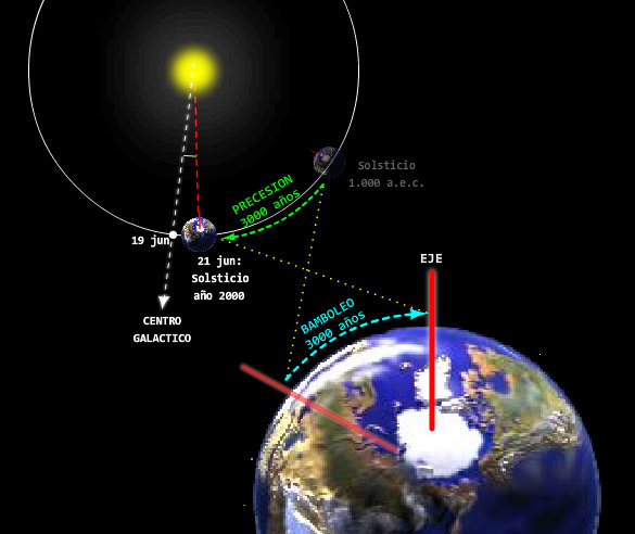
Actualmente, cada 19 de junio del calendario gregoriano, la Nave Tierra en la que viajamos se coloca en el punto de su órbita en el que cruza por la línea que une al Sol y al centro de la Galaxia, es decir, que el planeta se coloca entre dos centros cósmicos: el centro del Sistema solar (el Sol) y el común a todas las estrellas, el Centro de la Galaxia. El centro del Ser galáctico es el punto de referencia fundamental para nuestra orientación en un Espacio en el que no existen fechas ni horas, y por ello es un "vacío terrible" para la mente acostumbrada a "marcapasos".
Teniendo en cuenta que el Sol (Sistema solar, y con él las órbitas de los planetas como la Tierra) gira alrededor de otro centro como puede ser el propio centro galáctico, y que los calendarios son estructuras mentales estáticas no vivientes y por ello incapaces de adaptarse a la dinámica de los movimientos de los astros en el Espacio, es fácil imaginar que hace 2000 años (por ejemplo) esta circunstancia ocurriera en otra fecha, en tal caso de hace 2000 años el 24 de mayo. Pero para los astros no existen nuestras fechas sino sus movimientos circulares y sus alineaciones que se producen cíclicamente en el infinito EspacioTiempo (88) del Ser universal. Sus astros (sus reflejos, sus señales, nuestros guías) son los puentes para la reintegración de nuestra conciencia en la dinámica universal. Los calendarios, al ser estáticos, "congelan" la conciencia, y se hacen útiles sólo para una existencia lineal con una esperanza media de 70 años (tal es la duración media de una persona moderna).
Durante el solsticio de verano, el 21 de Junio, el Sol salía por el Noreste a 28º a la izquierda de la visión de la esfinge.

3. Equinoccio de Otoño. Durante el equinoccio de otoño, el 21 de Septiembre, el Sol salía justo por el Este durante 2 días.

4. Solsticio de invierno. Durante el solsticio de invierno, el 21 de Diciembre, el Sol salía a 28º Sureste de la visión de la esfinge.

http://sercomunitario2010ulahumanidades.blogspot.com/2011/06/el-m-d-del-solsticiohor-em-akhet-del.html
La conexion con "la serpiente de bronce" esta codificada en funcion al mismo signo $$$ al tener forma de serpiente. Recordemos que la SERPIENTE segun GENESIS es la misma tribu de DAN con nexo con A-DAN.
7. Génesis 49:17: Será Dan SERPIENTE junto al camino, Víbora junto a la senda, Que muerde los talones del caballo, Y hace caer hacia atrás al jinete.
6. Génesis 3:14: Y Jehová Dios dijo a la SERPIENTE: Por cuanto esto hiciste, maldita serás entre todas las bestias y entre todos los animales del campo; sobre tu pecho andarás, y polvo comerás todos los días de tu vida.
8. Número 21:6: Y Jehová envió entre el pueblo SERPIENTEs ardientes, que mordían al pueblo; y murió mucho pueblo de Israel.
9. Número 21:7: Entonces el pueblo vino a Moisés y dijo: Hemos pecado por haber hablado contra Jehová, y contra ti; ruega a Jehová que quite de nosotros estas SERPIENTEs. Y Moisés oró por el pueblo.
10. Número 21:8: Y Jehová dijo a Moisés: Hazte una SERPIENTE ardiente, y ponla sobre una asta; y cualquiera que fuere mordido y mirare a ella, vivirá.
11. Número 21:9: Y Moisés hizo una SERPIENTE de bronce, y la puso sobre una asta; y cuando alguna SERPIENTE mordía a alguno, miraba a la SERPIENTE de bronce, y vivía.
LA ESFINGE DE GIZE TIENE CARA DE MUJER (VIRGO) CON CUERPO DE LEON (LEO). EN EL MISMO BILLETE DE UN DOLAR, MONEDA DE USO MUNDIAL, ESTA CODIFICADO EL LINAJE DE ADAN Y EVA. Esto explica desde OTRA PERSPECTIVA EL NEXO DAN BROWN CUYO LIBRO "EL CODIGO DA VINCI" FUE ESTRENADO EN EL AÑO 2003, A LOS 227 (22/7=3.14=PI), DE LA INDEPENDENCIA DE EEUU (2003-1776=227). Recordemos que dicha cifra tambien es la misma que hay desde el 1 de enero hasta el 15 de Agosto (asuncion de la virgen). EN EL MISMO DOLAR ESTABA CODIFICADO EL "CODIGO DA VINCI" OBVIAMENTE BASADO EN PREMISAS BIBLICAS.
Everything is Connected and there are no
coincidences
|
|
|
|
|
PATRICK COWLEY
MEGATRON MAN
WASHINGTON D.C
MEGATRON
|
|
|
|
|

| washington in Simple Gematria Equals: 130 |
( |
w
23 |
a
1 |
s
19 |
h
8 |
i
9 |
n
14 |
g
7 |
t
20 |
o
15 |
n
14 |
) |
WASHINGTON D.C
|
|
|
|
|
NUMERO 19/DAN/OPHIUCO/ JUSTICIA/ $$$ / SCORPION / SOPHIA/ SABIDURIA / NUMERO DE ORO PHI/ PUERTA DE ORO
|
|
|
 Primer
Anterior
6 a 20 de 50
Siguiente Primer
Anterior
6 a 20 de 50
Siguiente Último
|