The Carnac stones (Breton: Steudadoù Karnag) are an exceptionally dense collection of megalithic sites near the south coast of Brittany in northwestern France, consisting of stone alignments (rows), dolmens (stone tombs), tumuli (burial mounds) and single menhirs (standing stones). More than 3,000 prehistoric standing stones were hewn from local granite and erected by the pre-Celtic people of Brittany and form the largest such collection in the world.[1] Most of the stones are within the Breton municipality of Carnac, but some to the east are within neighboring La Trinité-sur-Mer. The stones were erected at some stage during the Neolithic period, probably around 3300 BC, but some may date to as early as 4500 BC.[2]
Although the stones date from 4500–3300 BC, modern beliefs associated them with 1st century AD Roman and later Christian occupations. A Christian legend associated with the stones held that they were pagan soldiers in pursuit of Pope Cornelius when he turned them to stone.[3][4][5] Brittany has its own local versions of the Arthurian cycle. Local tradition similarly claims that the reason they stand in such perfectly straight lines is that they are a Roman legion turned to stone by Merlin.
In recent centuries, many of the sites have been neglected, with reports of dolmens being used as sheep shelters, chicken sheds or even ovens.[6] Even more commonly, stones have been removed to make way for roads, or as building materials. The continuing management of the sites remains a controversial topic.[1][7]
According to Neil Oliver's BBC documentary A History of Ancient Britain,[8] the alignments would have been built by hunter-gatherer people ("These weren't erected by Neolithic farmers, but by Mesolithic hunters"). That would place them in a different category from Stonehenge in England, which has been claimed to be the work of Early European Farmers.[9] The question of which people Carnac stones are to be attributed to is still debated.[10]

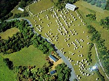
Model of the
Ménec alignment

Model of the
Kermario alignment
Model of the
Kerlescan alignment
There are three major groups of stone rows – Ménec, Kermario and Kerlescan. They may have once formed a single group but have been split up as stones were removed for other purposes.
The standing stones are made of weathered granite from local outcroppings that once extensively covered the area.[11]
Eleven converging rows of menhirs stretching for 1,165 by 100 metres (3,822 by 328 feet). There are what Alexander Thom considered to be the remains of stone circles at either end. According to the tourist office there is a "cromlech containing 71 stone blocks" at the western end and a very ruined cromlech at the eastern end. The largest stones, around 4 metres (13 feet) high, are at the wider, western end; the stones then become as small as 0.6 metres (2 feet 0 inches) high along the length of the alignment before growing in height again toward the extreme eastern end.
Kermario alignment
[edit]
This fan-like layout recurs a little further along to the east in the Kermario (House of the Dead)[12] alignment. It consists of 1029 stones[13] in ten columns, about 1,300 m (4,300 ft) in length.[citation needed] A stone circle to the east end, where the stones are shorter, was revealed by aerial photography.[14]
Kerlescan alignments
[edit]
A smaller group of 555 stones, further to the east of the other two sites. It is composed of 13 lines with a total length of about 800 metres (2,600 ft), ranging in height from 80 cm (2 ft 7 in) to 4 m (13 ft).[15] At the extreme west, where the stones are tallest, there is a stone circle which has 39 stones. There may also be another stone circle to the north.[citation needed]
Petit-Ménec alignments
[edit]
A much smaller group, further east again of Kerlescan, falling within the commune of La Trinité-sur-Mer. These are now set in woods, and most are covered with moss and ivy.[16]
There are several tumuli, mounds of earth built up over a grave. In this area, they generally feature a passage leading to a central chamber which once held neolithic artifacts.
Three exceptionally large burial mounds are known from the Carnac and Morbihan area, dating from the mid-5th millennium BC and known collectively as 'Carnacéen tumuli': Saint-Michel, Tumiac and Mané-er-Hroëk.[17] Each of these tumuli contained a megalithic burial chamber, containing the burial of only one individual, along with numerous large polished stone axeheads, stone arm-rings, and jewellery made from callaïs (variscite and turquoise).[18] Scientific analyses have shown that many of the axeheads are made of jade from the Italian Alps, whilst the callaïs was imported from south-western Iberia.[19][20] Archaeological evidence indicates that the callaïs was brought from Iberia by boat, across the Bay of Biscay, rather than along the coast or overland.[19] Some of the Carnacéen jade axeheads are up to 46 cm in length and may have taken over a thousand hours to produce, on top of the time required to quarry the material and transport it to Carnac.[21] The extraordinary nature of these burials, the scale of the tumuli, the logistics and effort involved, all indicate that these were the burials of extremely important elite individuals, that some researchers have described as "divine kings".[22][23][24] The large-scale effort and organisation involved in the construction of megalithic monuments, such as the 20.6 metre-tall Grand Menhir of Er Grah, further suggests the existence of rulers or kings in the Carnac and Morbihan region.[25][26][27] A similar situation has been described for the later megalithic culture in Ireland, which shows some close similarities to the megalithic culture in Brittany.[28] Based on archaeological, DNA and ethnographic evidence it has been suggested that an elite male buried in the Newgrange passage grave, c. 3200 BC, may have been a "god-king" and part of a "dynastic elite".[29] Similarities have also been noted with the Michelsberg culture in northeastern France and Germany (c. 4200 BC), which featured large tumulus burials within fortified settlements and the use of Alpine jade axes, all associated with the emergence of "high-ranking elites".[30][31] Engravings on megalithic monuments in Carnac also feature numerous depictions of objects interpreted as symbols of authority and power, such as curved throwing weapons, axes and sceptres.[32][33]
The Carnacéen tumuli were contemporary with the rich burials of the Varna culture in Bulgaria (c. 4500 BC), which contained more gold than all excavated sites from the rest of the world combined in the 5th millennium BC.[34] The Varna burials attest to the existence of powerful elites in southeastern Europe at the same time as they appear in Carnac.[35] Grave 43 of the Varna necropolis, which contained a single male buried with a sceptre and numerous gold ornaments, also contained an Alpine jade axehead.[36][37]
The tumulus of Saint-Michel was constructed between 5000 BCE and 3400 BCE. At its base it is 125 by 60 m (410 by 197 ft), and is 12 m (39 ft) high. It required 35,000 cubic metres (46,000 cu yd) of stone and earth. Its function was a tomb for the members of the ruling class. It contained various funerary objects, such as 15 stone chests, large jade axes, pottery, and callaïs jewellery, most of which are currently held by the Museum of Prehistory of Carnac.[38] It was excavated in 1862 by René Galles with a series of vertical pits, digging down 8 m (26 ft). Le Rouzic also excavated it between 1900 and 1907, discovering the tomb and the stone chests.[39]
A chapel was built on top in 1663 and was rebuilt in 1813, before being destroyed in 1923. The current building is an identical reconstruction of the 1663 chapel, built in 1926.

Tumulus of Tumiac
The tumulus of Tumiac is located in Arzon, in the Rhuys peninsula, south of the Gulf of Morbihan. It is also known as 'Caesar's mound' because, according to local legend, it served as an observatory for Julius Caesar during his war against the Veneti in 56 BC.
The site was excavated in 1853. The crater visible at the top of the tumulus corresponds to the vertical hole made at the time for its exploration. It was the subject of new excavations and work in 1934, which brought to light several secondary burials.
The tumulus, circular/elliptical in shape, is made up of layers of clay. It measures 50 m in diameter and 15 m in height. It contains a central rectangular burial chamber 4.40 m long, 2.40 m wide and 1.75 m high. This chamber is made up of three monolithic supports and is covered with a quartz slab 4.80 m long. It had a wooden floor and two engraved side slabs. The funerary chamber contained rich furniture consisting of 11 jadeite axes, 26 fibrolite axes and 249 callaïs beads. These objects are kept in the Archaeological Museum of Vannes. According to carbon-14 dating, the tumulus of Tumiac was erected between 4790 and 4530 BC.
The tumulus of Tumiac has been classified as a historical monument since 1923.

Entrance to the Mané-er-Hroëk burial chamber
The Tumulus of Mané-er-Hroëk (also known as the Tumulus du Ruyk) is located in Locmariaquer, Morbihan, immediately west of the hamlet of Er-Hroueg and about 1 km northeast of the Pierres Plates dolmen.
The tumulus comprises a rectangular burial vault of about 5 m by 3 m, covered with two roofing slabs, supporting a mound about 100 m long and 60 m wide. The tumulus rises to approximately 15 m above sea level, or almost 8 m above the natural ground. The current entrance, with a staircase, is a modern addition. An engraved stele, found broken into three pieces, stands next to the entrance.