|
|
Columbus and the Templars
Was Columbus using old Templar maps when he crossed the Atlantic? At first blush, the navigator and the fighting monks seem like odd bedfellows. But once I began ferreting around in this dusty corner of history, I found some fascinating connections. Enough, in fact, to trigger the plot of my latest novel, The Swagger Sword.
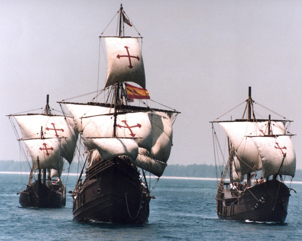
To begin with, most history buffs know there are some obvious connections between Columbus and the Knights Templar. Most prominently, the sails on Columbus’ ships featured the unique splayed Templar cross known as the cross pattée (pictured here is the Santa Maria):
Additionally, in his later years Columbus featured a so-called “Hooked X” in his signature, a mark believed by researchers such as Scott Wolter to be a secret code used by remnants of the outlawed Templars (see two large X letters with barbs on upper right staves pictured below):
Other connections between Columbus and the Templars are less well-known. For example, Columbus grew up in Genoa, bordering the principality of Seborga, the location of the Templars’ original headquarters and the repository of many of the documents and maps brought by the Templars to Europe from the Middle East. Could Columbus have been privy to these maps? Later in life, Columbus married into a prominent Templar family. His father-in-law, Bartolomeu Perestrello (a nobleman and accomplished navigator in his own right), was a member of the Knights of Christ (the Portuguese successor order to the Templars). Perestrello was known to possess a rare and wide-ranging collection of maritime logs, maps and charts; it has been written that Columbus was given a key to Perestrello’s library as part of the marriage dowry. After marrying, Columbus moved to the remote Madeira Islands, where a fellow resident, John Drummond, had also married into the Perestrello family. Drummond was a grandson of Scottish explorer Prince Henry Sinclair, believed to have sailed to North America in 1398. It is, accordingly, likely that Columbus had access to extensive Templar maps and charts through his familial connections to both Perestrello and Drummond.
Another little-known incident in Columbus’ life sheds further light on the navigator’s possible ties to the Templars. In 1477, Columbus sailed to Galway, on the west coast of Ireland, from where the legendary Brendan the Navigator supposedly set sale in the 6th century on his journey to North America. While there, Columbus prayed at St. Nicholas’ Church, a structure built over an original Templar chapel dating back to around the year 1300. St. Nicholas’ Church has been compared by some historians to Scotland’s famous Roslyn Chapel, complete with Templar tomb, Apprentice Pillar, and hidden Templar crosses. (Recall that Roslyn Chapel was built by another grandson—not Drummond—of the aforementioned Prince Henry Sinclair.) According to his diary, Columbus also famously observed “Chinese” bodies floating into Galway harbor on driftwood, which may have been what first prompted him to turn his eyes westward. A granite monument along the Galway waterfront, topped by a dove (Columbus meaning ‘dove’ in Latin), commemorates this sighting, the marker reading: On these shores around 1477 the Genoese sailor Christoforo Colombo found sure signs of land beyond the Atlantic.
In fact, as the monument text hints, Columbus may have turned more than just his eyes westward. A growing body of evidence indicates he actually crossed the north Atlantic in 1477. Columbus wrote in a letter to his son: “In the year 1477, in the month of February, I navigated 100 leagues beyond Thule [to an] island which is as large as England. When I was there the sea was not frozen over, and the tide was so great as to rise and fall 26 braccias.” We will turn later to the mystery as to why any sailor would venture into the north Atlantic in February. First, let’s examine Columbus’ statement. Historically, ‘Thule’ is the name given to the westernmost edge of the known world. In 1477, that would have been the western settlements of Greenland (though abandoned by then, they were still known). A league is about three miles, so 100 leagues is approximately 300 miles. If we think of the word “beyond” as meaning “further than” rather than merely “from,” we then need to look for an island the size of England with massive tides (26 braccias equaling approximately 50 feet) located along a longitudinal line 300 miles west of the west coast of Greenland and far enough south so that the harbors were not frozen over. Nova Scotia, with its famous Bay of Fundy tides, matches the description almost perfectly. But, again, why would Columbus brave the north Atlantic in mid-winter? The answer comes from researcher Anne Molander, who in her book, The Horizons of Christopher Columbus, places Columbus in Nova Scotia on February 13, 1477. His motivation? To view and take measurements during a solar eclipse. Ms. Molander theorizes that the navigator, who was known to track celestial events such as eclipses, used the rare opportunity to view the eclipse elevation angle in order calculate the exact longitude of the eastern coastline of North America. Recall that, during this time period, trained navigators were adept at calculating latitude, but reliable methods for measuring longitude had not yet been invented. Columbus, apparently, was using the rare 1477 eclipse to gather date for future western exploration. Curiously, Ms. Molander places Columbus specifically in Nova Scotia’s Clark’s Bay, less than a day’s sail from the famous Oak Island, legendary repository of the Knights Templar missing treasure.
The Columbus-Templar connections detailed above were intriguing, but it wasn’t until I studied the names of the three ships which Columbus sailed to America that I became convinced the link was a reality. Before examining these ship names, let’s delve a bit deeper into some of the history referred to earlier in this analysis. I made a reference to Prince Henry Sinclair and his journey to North American in 1398. The Da Vinci Code made the Sinclair/St. Clair family famous by identifying it as the family most likely to be carrying the Jesus bloodline. As mentioned earlier, this is the same family which in the mid-1400s built Roslyn Chapel, an edifice some historians believe holds the key—through its elaborate and esoteric carvings and decorations—to locating the Holy Grail. Other historians believe the chapel houses (or housed) the hidden Knights Templar treasure. Whatever the case, the Sinclair/St. Clair family has a long and intimate historical connection to the Knights Templar. In fact, a growing number of researchers believe that the purpose of Prince Henry Sinclair’s 1398 expedition to North America was to hide the Templar treasure (whether it be a monetary treasure or something more esoteric such as religious artifacts or secret documents revealing the true teachings of the early Church). Researcher Scott Wolter, in studying the Hooked X mark found on many ancient artifacts in North American as well as on Columbus’ signature, makes a compelling argument that the Hooked X is in fact a secret symbol used by those who believed that Jesus and Mary Magdalene married and produced children. (See The Hooked X, by Scott F. Wolter.) These believers adhered to a version of Christianity which recognized the importance of the female in both society and in religion, putting them at odds with the patriarchal Church. In this belief, they had returned to the ancient pre-Old Testament ways, where the female form was worshiped and deified as the primary giver of life.
It is through the prism of this Jesus and Mary Magdalene marriage, and the Sinclair/St. Clair family connection to both the Jesus bloodline and Columbus, that we now, finally, turn to the names of Columbus’ three ships. Importantly, he renamed all three ships before his 1492 expedition. The largest vessel’s name, the Santa Maria, is the easiest to analyze: Saint Mary, the Virgin Mary, the mother of Jesus. The Pinta is more of a mystery. In Spanish, the word means ‘the painted one.’ During the time of Columbus, this was a name attributed to prostitutes, who “painted” their faces with makeup. Also during this period, the Church had marginalized Mary Magdalene by referring to her as ‘the prostitute,’ even though there is nothing in the New Testament identifying her as such. So the Pinta could very well be a reference to Mary Magdalene. Last is the Nina, Spanish for ‘the girl.’ Could this be the daughter of Mary Magdalene, the carrier of the Jesus bloodline? If so, it would complete the set of women in Jesus’ life—his mother, his wife, his daughter—and be a nod to those who opposed the patriarchy of the medieval Church. It was only when I researched further that I realized I was on the right track: The name of the Pinta before Columbus changed it was the Santa Clara, Portuguese for ‘Saint Clair.’
So, to put a bow on it, Columbus named his three ships after the Virgin Mary, Mary Magdalene, and the carrier of their bloodline, the St. Clair girl. These namings occurred during the height of the Inquisition, when one needed to be extremely careful about doing anything which could be interpreted as heretical. But even given the danger, I find it hard to chalk these names up to coincidence, especially in light of all the other Columbus connections to the Templars. Columbus was intent on paying homage to the Templars and their beliefs, and found a subtle way of renaming his ships to do so.
Given all this, I have to wonder: Was Columbus using Templar maps when he made his Atlantic crossing? Is this why he stayed south, because the maps showed no passage to the north? If so, and especially in light of his 1477 journey to an area so close to Oak Island, what services had Columbus provided the Templars in exchange for these priceless charts?
It is this research, and these questions, which triggered my novel, The Swagger Sword. If you appreciate a good historical mystery as much as I, I think you’ll enjoy the story.
http://westfordknight.blogspot.com/2018/09/columbus-and-templars.html |
|
|
|
|
GAINING TRUST FROM QUEEN ISABELLA
In 1485, Columbus presented his plans of crossing the Atlantic to John II, King of Portugal. He proposed that the king equip three sturdy ships and grant Columbus one year's time to sail out into the Atlantic, search for a western route to the Orient, and return.
Columbus also requested he be made "Great Admiral of the Ocean", appointed governor of any and all lands he discovered, and given one-tenth of all revenue from those lands.
The king submitted Columbus' proposal to his experts, who rejected it. It was their considered opinion that Columbus' estimation of a travel distance of 2,400 miles (3,860 km) was, in fact, far too low.
In 1488, Columbus appealed to the court of Portugal once again, and once again, John II invited him to an audience. That meeting also proved unsuccessful, in part because not long afterwards Bartolomeu Dias returned to Portugal with news of his successful rounding of the southern tip of Africa (near the Cape of Good Hope). With an eastern sea route to Asia apparently at hand, King John was no longer interested in Columbus's far-fetched project.
Columbus traveled from Portugal to both Genoa and Venice, but he received encouragement from neither. Columbus had also dispatched his brother Bartholomew to the court of Henry VII of England, to inquire whether the English crown might sponsor his expedition, but also without success.
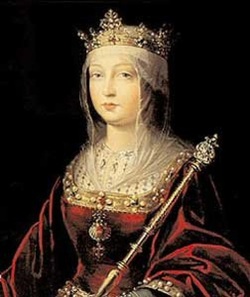
Columbus had sought an audience from the monarchs Ferdinand II of Aragon and Isabella I of Castile, who had united many kingdoms in the Iberian Peninsula by marrying, and were ruling together. On 1 May 1486, permission having been granted, Columbus presented his plans to Queen Isabella, who, in turn, referred it to a committee. After the passing of much time, the savants of Spain, like their counterparts in Portugal, replied that Columbus had grossly underestimated the distance to Asia. They pronounced the idea impractical and advised their Royal Highnesses to pass on the proposed venture.
However, to keep Columbus from taking his ideas elsewhere, and perhaps to keep their options open, the Catholic Monarchs gave him an annual allowance of 12,000 maravedis and, in 1489, furnished him with a letter ordering all cities and towns under their domain to provide him food and lodging at no cost.
After continually lobbying at the Spanish court and two years of negotiations, he finally had success in January 1492. Ferdinand and Isabella had just conquered Granada, the last Muslim stronghold on the Iberian Peninsula, and they received Columbus in Córdoba, in the Alcázar castle. Isabella turned Columbus down on the advice of her confessor, and he was leaving town by mule in despair, when Ferdinand intervened. Isabella then sent a royal guard to fetch him, and Ferdinand later claimed credit for being "the principal cause why those islands were discovered".
About half of the financing was to come from private Italian investors, whom Columbus had already lined up.
https://hhscolumbus.weebly.com/queen-isabella.html |
|
|
|
|
QUEST OF THE CARIBBEAN ™
For the entire 15th century, a prophecy had circulated that “the restorer of the House of Mt. Zion will come from Spain. ” For hundreds of years, the holy sites of Jerusalem had been held captive by the Muslims. But according to ancient prophecy, that day would soon end. And Columbus believed he would be part of making it happen. In his a pursuit, and beyond doubt, Columbus sailed to fulfill a religious quest. Columbus’s voyages were intense religious missions. He saw them as the fulfillment of a divine plan for his life—and for the soon-coming end of the world. As he put it in 1500, “God made me the messenger of the new heaven and the new earth of which he spoke in the Apocalypse of St. John [Rev. 21:1] after having spoken of it through the mouth of Isaiah; and he showed me the spot where to find it. ”
Columbus thought that Ferdinand and Isabella were God’s chosen instruments to recapture Jerusalem and place the Holy City under Christian control. This was not some sidelight in Columbus’s mind; it was a central passion. As scholar Pauline Moffitt Watts has written, “This was Columbus’s ultimate goal, the purpose of all his travels and discoveries—the liberation of the Holy Land. ” The Crusaders Book of Secrets, written in the early fourteenth century, said it would take 210,000 gold florins to mount a new crusade. If Columbus could find enough gold in the Indies especially if he could find the lost mines of Solomon, which were known to be in the East—he could pay for a Holy Land crusade. That is what started his quest...
 |
The Knights Templar by the end of the 14th century had established effectively an monarch, an international identity with its head, the Grand Master, exercising the role of sovereignty. Having established a system of banking from England to the Levant, vast agricultural holdings, and a military and naval force, the people of their communities enjoyed relative peace, better nutrition and ability to travel.
The King of France sought to plunder their wealth by an infamous inquistion that began on Friday the 13th, 1307. By 1312, a complicit Pope ordered the dissolution of the Order, and Europe plunged into strife and famine. The Black Death, also known as the Great Plague, was one of the most devastating pandemics in human history, resulting in the deaths of an estimated 75 to 200 million people in Eurasia and peaking in Europe from 1347 to 1351. People began looking for religous freedom, new lands, adventure, and food. The completed conquest of Granada was the context of the Spanish voyages of discovery and conquest (Columbus got royal support in Granada in 1492, months after its conquest), and the Americas—the "New World"—ushered in the era of the Spanish and Portuguese colonial empires. The antillean isles would quickly follow...
|
During the Age of Discovery, the conquistadors were Knights that sailed beyond Europe to the Americas, Oceania, Africa and Asia, claiming territory and opening trade routes. They colonized much of the world for Britain, Spain, the Dutch Republic, and Portugal in the 16th, 17th and 18th centuries. In what has become known as the Columbian Exchange, Columbus’ voyages enabled the exchange of plants, animals, cultures, ideas (and, yes, disease) between the Western and Eastern Hemispheres. Once the Europeans were able to reach nearly all parts of the globe, a new modern age would begin, transforming the world forever.
Much has been published of Columbus' connections with the Knights Templar. He was married to a daughter of a former Grand Master of the Knights of Christ, a Portuguese order that had emerged after the Templars had been driven underground. It's been noted as significant that Columbus navigated ships whose sails carried the distinctive Red Cross 'patte' of the Templars.
Christopher Columbus was looking for a western route to the Orient, and he carried with him letters of introduction to the Great Khan of China. His mission was to convince the Great Kahn to join forces and reclaim Jerusalem under the Christian Flag. All of the significant Caribbean islands were first discovered by Knights (and Conquistadors) from Europe. Most people think in terms of the “Crusades” having been conducted in the Holy Land of Jerusalem from the eleventh through the thirteenth centuries. However, the Crusades actually continued throughout the sixteenth century into the New World.
Effectively, the crusades of the Americas were founded by the same religious, military Orders for the very reason of executing plans to explore the world, make contact with the Great Khan and mobilize an army to retake Jerusalem. Christopher Columbus and his voyages were backed and financed by the Brotherhood and the Church of Rome, with his ships' sails bearing Red Cross on a white background, the symbol of the Knights Templar.
The Hospitaller colonization of the Americas occurred during a 14-year period in which the Knights of St. John (Knights of Malta) possessed four Caribbean islands: Saint Christopher, Saint Martin, Saint Barthélemy, and Saint Croix.
The Knights' presence in the Caribbean grew out of their order's close relationship with the French nobility and the presence of many members in the Americas as French administrators. The key figure in their brief colonization was Phillippe de Longvilliers de Poincy, who was both a Knight of St. John and governor of the French colonies in the Caribbean. Poincy convinced the Knights to purchase the islands of the Lesser Antilles from the bankrupt Compagnie des Îles de l'Amérique in 1651 and remained to govern them until his death in 1660. During this time, the Order acted as proprietor of the islands, while the King of France continued to hold nominal sovereignty.
Poincy was not only a naval admiral, but also an agronomist. He established the successful cultivation of sugar cane and by the end of the 17th century, St. Christopher and Nevis' exports of 'white gold' would exceed the gross products of the entire continental america. Spain plundered only for gold, while the rest of Europe sought stabile colonization and establishment of the New Jerusalem. The world's most beautiful tree, the Royal Poinciana, would later be named after him. Sir Poincy established the most beautiful estate, La Fontaine, known in the Caribbean with least assistance from mother France. The colonists of France in Britian were largely left to fend on their own. Each island was left to create its own mini-monarch, and that would include Pirate Republics. This is a large part of the untold history of the Caribbean. Read these web pages for the corrected perspective...
http://aosj.org/quest.html
|
|
|
|
|
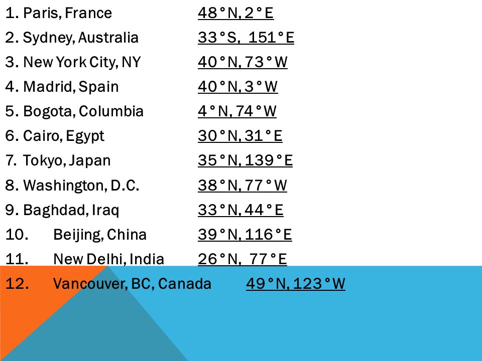
Columbia (Carolina del Sur)
Columbia es la capital y segunda ciudad más poblada (136 632 habitantes en 2020) del estado estadounidense de Carolina del Sur. Ubicada en los condados de Richland y Lexington, se encuentra en el centro del estado, en la zona donde confluyen los ríos Saluda y Broad, formando el río Congaree.1
La ciudad fue fundada el 22 de marzo de 1786, nombrada en honor al descubridor del continente americano, el navegante Cristóbal Colón. En su mayor parte corresponde a un estilo residencial suburbano.2
 Ubicación de Columbia en un mapa de la cuenca del rio Santee
Columbia se encuentra ubicada en las coordenadas  33°59′27″N 81°4′4″O. Según la Oficina del Censo, la ciudad tiene un área total de 133,8 km² (51,7 mi²), de la cual 131,3 km² (50,7 mi²) es tierra y 6,4 km² (2,5 mi²) (1.96%) es agua. 33°59′27″N 81°4′4″O. Según la Oficina del Censo, la ciudad tiene un área total de 133,8 km² (51,7 mi²), de la cual 131,3 km² (50,7 mi²) es tierra y 6,4 km² (2,5 mi²) (1.96%) es agua.
|
|
|
|
|
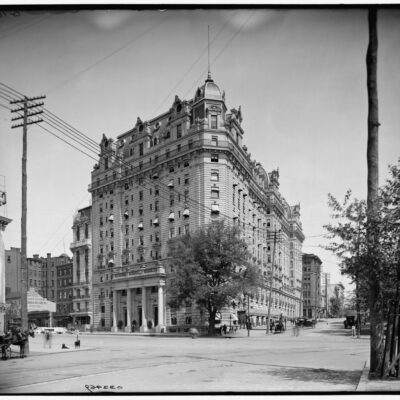
https://ghostsofdc.org/2013/07/24/washington-dc-district-of-columbia/ |
|
|
 Primer
Anterior
12 a 26 de 26
Siguiente Primer
Anterior
12 a 26 de 26
Siguiente
 Último
|


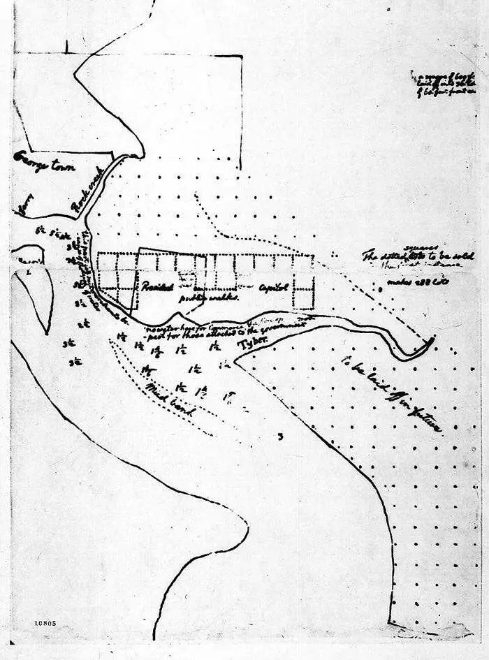 sketch of new federal capital by Thomas Jefferson (March 1791)
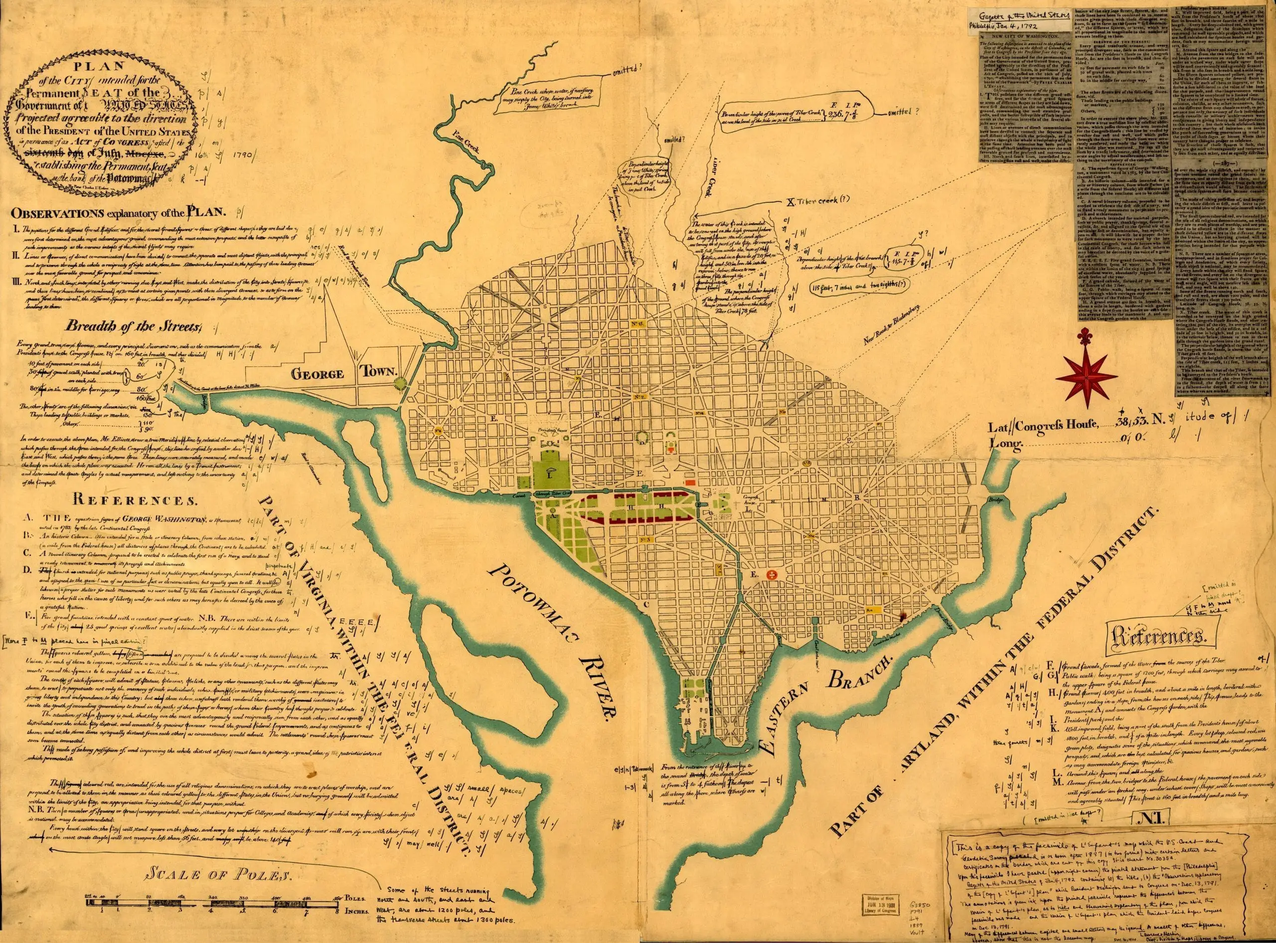 Plan of the city intended for the permanent seat of the government of the United States…