IMPRESIONANTE CONEXION 11 DE SEPTIEMBRE DEL 2001, 11 DE MARZO DEL 2004 Y 7 DE JULIO DEL 2004 CON EL 22 DE DICIEMBRE DEL 2012-FUERTE INTERRELACION DE WASHINGTON D.C (DISTRICT OF COLUMBIA) CON COLOMBIA (RIO MARIA MAGDALENA)-DICHO RIO ESTA UBICADO ENTRE LOS MERIDANO 74 WEST (NUEVA YORK) Y 77 WEST (WASHINGTON D.C)
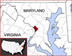
Hay un impresionante interrelacion del 911 con la REPUBLICA DE COLOMBIA en el contexto al RIO MARIA MAGDALENA que esta ubicado entre los meridianos de NUEVA YORK (MERIDIANO 74W) Y WASHINGTON D.C (MERIDIANO 77W). WASHINGTON D.C esta ubicado actualmente en el estado de COLUMBIA. Recordemos que la tierra adonde esta ubicada la capital actual de los EEUU fue donada por los ESTADOS DE MARYLAND Y VIRGINIA (HAY un obvio nexo con MARIA MAGDALENA). Otro nexo con el 77 tambien lo tenemos en la BOMBA DE LONDRES que fue un 7/7/2004.
OBSERVEN EL NEXO WEST VIRGINIA, VIRGINIA Y PHILADELPHIA. ESTA TODO CODIFICADO PARA GLORIA DE YHWH TODOPODEROSO. ES OBVIO EL NEXO DE LA VIRGEN CON EL NUMERO DE ORO PHI PARA QUE A USTED NO QUEDE DUDA. YHWH NOS INVITA A SALIR DE BABILONIA(BABY-LON/CONFU-SION)- LON-DON/BABY-LON. BABY TIENE NEXO CON DON/DAN/JUSTICIA/JUICIO EN LA TORA. LA VIUDA PIDE JUSTICIA.
Santa Marta Map — Satellite Images of Santa Marta
original name: Santa Marta geographical location: Santa Marta (Dist. Esp.), Magdalena, Colombia, South America geographical coordinates: 11° 14' 50" North, 74° 12' 6" West
Welcome to the Santa Marta google satellite map! This place is situated in Santa Marta (Dist. Esp.), Magdalena, Colombia, its geographical coordinates are 11° 14' 50" North, 74° 12' 6" West and its original name (with diacritics) is Santa Marta. See Santa Marta photos and images from satellite below, explore the aerial photographs of Santa Marta in Colombia. Santa Marta hotels map is available on the target page linked above
AQUI HAY un mapa adonde vemos el RIO MARIA MAGDALENA e incluso vemos que la actual CAPITAL DE COLOMBIA (SANTA FE DE BOGOTA) TIENE UN NEXO CON EL "MISTERIO DE LA FE" EN LA ACTUAL MISA CATOLICA.
CONCRETAMENTE EL 911 TIENE FUERTE NEXO ESPIRITUAL CON LA "CONSPIRACION" CONTRA MARIA MAGDALENA Y EL SANTO GRIAL. EN ESTE CASO YA LO VEMOS POR PRUEBAS GEOGRAFICAS. YHWH MANEJA TODO PARA MALDICION DE LOS EGOLATRAS E IDOLATRAS. LA UNICA VERDAD ES LA DE YHWH, EN CRISTO Y MAGDALENA.
LA TOLERANCIA ES BUENA, PERO JAMAS SERÁ MAS GRANDE QUE LA VERDAD
"La verdad es la verdad aunque solo haya uno que la defienda".
Juan 8:32: y conoceréis la VERDAD, y la VERDAD os hará libres.
La conexion 911 con LONDRES, en contexto al NUMERO 8, aparentemente tiene nexo CON LA NACION DE LA REINA DE LOS MARES. UN FUERTE NEXO ESOTERICO CON MARIA MAGDALENA.
Gordon "Gordy" Brewer (Arnold Schwarzenegger), es un bombero de la ciudad de Los Ángeles que vive con Anne (Lindsay Frost), su esposa. Una mañana ella se lleva al hijo de ambos, Matt (Ethan Dampf), al médico y él accede a recogerlos más tarde. Mas tarde
son asesinados la esposa y el hijo de GORDON (ARNOLD SCHWARZENEGGER
).
Más tarde, ve en las noticias las imágenes de la explosión y se fija que la moto era del policía, e informa al FBI de ello. El FBI se lo lleva para ser interrogado, le muestran un video terrorista y descubre que el policía era en realidad el terrorista llamado "El Lobo" y que el ataque tenía como objetivo al agente de la CIA Peter Brandt (Elias Koteas) debido a las actividades de
dicha organización en Colombia
. Le dicen que “El Lobo” ha vuelto a Colombia y no hay nada que puedan hacer, pero “Gordy” se niega a ello y decide ir tras él.
Después de eludir muchos guerrilleros en la selva, “Gordy” finalmente se infiltra en la zona donde opera la guerrilla. Es localizado tanto por la guerrilla (quienes lo quieren capturar para pedir rescate) como por la CIA (quienes no quieren que se inmiscuya en sus planes) y por la policía, pero son estos últimos quienes llegan primero hasta él y lo encierran en una prisión. Una vez allí, contacta con un estafador canadiense, Sean Armstrong (John Turturro). Los terroristas atacan la prisión para tratar de llegar a “Gordy” y liberar a algunos de sus miembros, pero “Gordy” consigue escapar y rescata a Sean. Sean le devuelve el favor ayudándolo a encontrar a Félix Ramírez (John Leguizamo), que gestiona la producción de droga que financia a los terroristas.
Después de alcanzar la planta de drogas, “Gordy” la destruye con explosivos. Félix es culpado por ello y ejecutado instantáneamente.
A continuación, “Gordy” se infiltra en el cuartel de "El Lobo", donde planta una bomba cerca de su habitación y se marcha. Desde fuera observa a una mujer y un niño caminando hacia el edificio y se da cuenta que si los deja morir no será mejor que "El Lobo", así que corre hacia ellos para advertirles. "El Lobo" lo oye y salta fuera del edificio en el momento de la explosión. “Gordy” es capturado y recibe una paliza. La mujer, Selena Perrini (Francesca Neri) -la esposa de “El Lobo”- evita que sea asesinado.
“Gordy” es hecho prisionero. Él habla con Selena, tratando de obtener su ayuda. Selena le explica a “Gordy” que su marido se volvió un terrorista como consecuencia de un ataque americano indiscriminado contra la guerrilla, el cual acabó con la vida de su hijo así como la de los padres del niño que ahora cuidan como su hijo. “Gordy” le dice que sin importar la razón, lo que está haciendo está mal y que ella lo debe ayudar a detenerlo. Selena dice que “Gordy” y "El Lobo" son lo mismo, consumidos por el odio y la venganza.
Mientras tanto, la explosión llama la atención de la CIA quienes localizan el campamento terrorista y lanzan un ataque. Durante la confusión, Selena ayuda a escapar a “Gordy” con la condición que la lleve a ella y su hijo a los Estados Unidos y le informa que "El Lobo" ha vuelto a Washington para otro ataque.
“Gordy”, Selena, y su hijo son devueltos al Departamento de Estado en Washington para ayudar a capturar a "El Lobo". Selena informa que el objetivo es Union Station y mientras el FBI va a investigar, Selena se va al baño y le pide a su hijo que le acompañe quien se niega pese al enfado de ella. “Gordy” le dice que su hijo estará bien y ella acepta a regañadientes. “Gordy” sospecha de esta extraña situación y entonces recuerda que la persona que apareció en el primer video que le mostró el FBI hacía los mismos gestos que Selena; se da cuenta que el verdadero objetivo era el Departamento de Estado, avisa a todos y lanza por la ventana el juguete del niño que no había sido comprobado justo antes de explotar.
“Gordy” persigue a Selena hasta el sótano del edificio, "El Lobo" está esperándola para escapar, pero “Gordy” manipula los controles del túnel y cierra las puertas principales. "El Lobo" y Selena tienen que volver a buscar los controles, “Gordy” abre algunas líneas de gas a lo largo de las paredes del túnel y espera. Selena dispara a “Gordy”, el disparo inflama el gas y el túnel explota, cuando “Gordy” vuelve a estudiar los daños, Selena y "El Lobo" habían sobrevivido y le atacan. Él lanza a Selena a través de un panel de control y muere electrocutada. "El Lobo" y “Gordy” siguen luchando, pero “Gordy” acaba con él.
Al final, “Gordy” abandona el Departamento de Estado junto con el hijo de Selena, mientras una voz en off informa que “Gordy” va a recibir la Medalla Presidencial de la Libertad al evitar una de los peores ataques terroristas en la historia de EE.UU.[2]
ESTA TODO EN CLAVE. YHWH MANEJA TODO.
EL MUNDO CIEGO, DE LO UNICO QUE HABLA ES DE $$$$$$$$$$ PARA "CAGARLO" AL PROJIMO.
The Jordan River, in the state of Utah, United States, is a river about 51 miles (82 km) long. Regulated by pumps at its headwaters at Utah Lake, it flows northward through the Salt Lake Valley and empties into the Great Salt Lake. Four of Utah's six largest cities border the river: Salt Lake City, West Valley City, West Jordan, and Sandy. More than a million people live in the Jordan Subbasin, part of the Jordan River watershed that lies within Salt Lake and Utah counties. During the Pleistocene, the area was part of Lake Bonneville.
Members of the Desert Archaic Culture were the earliest known inhabitants of the region; an archaeological site found along the river dates back 3,000 years. Mormon pioneers led by Brigham Young were the first European American settlers, arriving in July 1847 and establishing farms and settlements along the river and its tributaries. The growing population, needing water for drinking, irrigation, and industrial use in an arid climate, dug ditches and canals, built dams, and installed pumps to create a highly regulated river.
Although the Jordan was originally a cold-water fishery with 13 native species, including Bonneville cutthroat trout, it has become a warm-water fishery where the common carp is most abundant. It was heavily polluted for many years by raw sewage, agricultural runoff, and mining wastes. In the 1960s, sewage treatment removed many pollutants. In the 21st century, pollution is further limited by the Clean Water Act, and, in some cases, the Superfund program. Once the home of bighorn sheep and beaver, the contemporary river is frequented by raccoons, red foxes, and domestic pets. It is an important avian resource, as are the Great Salt Lake and Utah Lake, visited by more than 200 bird species.
The Jordan River is Utah Lake's only outflow. It originates at the northern end of the lake between the cities of Lehi and Saratoga Springs. It then meanders north through the north end of Utah Valley for approximately 8 miles (13 km) until it passes through a gorge in the Traverse Mountains, known as the Jordan Narrows. The Utah National Guard base at Camp Williams lies on the western side of the river through much of the Jordan Narrows.[7][8] The Turner Dam, located 41.8 miles (67.3 km) from the river's mouth (or at river mile 41.8) and within the boundaries of the Jordan Narrows, is the first of two dams of the Jordan River. Turner Dam diverts the water to the right or easterly into the East Jordan Canal and to the left or westerly toward the Utah and Salt Lake Canal. Two pumping stations situated next to Turner Dam divert water to the west into the Provo Reservoir Canal, Utah Lake Distribution Canal, and Jacob-Welby Canal. The Provo Reservoir Canal runs north through Salt Lake County, Jacob-Welby runs south through Utah County. The Utah Lake Distribution Canal runs both north and south, eventually leading back into Utah Lake.[9] Outside the narrows, the river reaches the second dam, known as Joint Dam, which is 39.9 miles (64.2 km) from the river's mouth. Joint Dam diverts water to the east for the Jordan and Salt Lake City Canal and to the west for the South Jordan Canal.[10][11][12]
Map of the Salt Lake Valley
The river then flows through the middle of the Salt Lake Valley, initially moving through the city of Bluffdale and then forming the border between the cities of Riverton and Draper.[7] The river then enters the city of South Jordan where it merges with Midas Creek from the west. Upon leaving South Jordan, the river forms the border between the cities of West Jordan on the west and Sandy and Midvale on the east. From the west, Bingham Creek enters West Jordan. Dry Creek, an eastern tributary, combines with the main river in Sandy. The river then forms the border between the cities of Taylorsville and West Valley City on the west and Murray and South Salt Lake on the east. The river flows underneath Interstate 215 in Murray. Little and Big Cottonwood Creeks enter from the east in Murray, 21.7 miles (34.9 km) and 20.6 miles (33.2 km) from the mouth respectively. Mill Creek enters on the east in South Salt Lake, 17.3 miles (27.8 km) from the mouth. The river runs through the middle of Salt Lake City, where the river travels underneath Interstate 80 a mile west of downtown Salt Lake City and again underneath Interstate 215 in the northern portion of Salt Lake City. Interstate 15 parallels the river's eastern flank throughout Salt Lake County. At 16 miles (26 km) from the mouth, the river enters the Surplus Canal channel. The Jordan River physically diverts from the Surplus Canal through four gates and heads north with the Surplus Canal heading northwest. Parley's, Emigration, and Red Butte Creeks converge from the east through an underground pipe, 14.2 miles (22.9 km) from the mouth.[7] City Creek also enters via an underground pipe, 11.5 miles (18.5 km) from the river's mouth. The length of the river and the elevation of its mouth varies year to year depending on the fluctuations of the Great Salt Lake caused by weather conditions. The lake has an average elevation of 4,200 feet (1,300 m) which can deviate by 10 feet (3.0 m).[3] The Jordan River then continues for 9 to 12 miles (14 to 19 km) with Salt Lake County on the west and North Salt Lake and Davis County on the east until it empties into the Great Salt Lake.[7][8][11]
The United States Geological Survey maintains a stream gauge in Salt Lake City that shows annual runoff from the period 1980–2003 is just over 150,000 acre-feet (190,000,000 m3) per year or 100 percent of the total 800,000 acre-feet (990,000,000 m3) of water entering the Jordan River from all sources. The Surplus Canal carries almost 60 percent of the water into the Great Salt Lake, with various irrigation canals responsible for the rest. The amount of water entering the Jordan River from Utah Lake is just over 400,000 acre-feet (490,000,000 m3) per year. Inflow from the 11 largest streams feeding the Jordan River, sewage treatment plants, and groundwater each account for approximately 15 percent of water entering the river.[13]
El relicario, que fue realizado aproximadamente entre 1190 y 1225 por el orfebre Nicolás de Verdún, es considerado el relicario más grande y artísticamente exigente que se ha conservado de la Edad Media. Está construido en dos niveles en forma de basílica y decorado con figuras doradas, joyas de piedras preciosas, gemas, camafeos y esmaltes, que ilustran la historia de la salvación cristiana desde los comienzos del Antiguo Testamento hasta el Juicio Final. Se le considera el punto culminante del arte mosano y el relicario más grande en el mundo occidental.
Moneda de plata de Colonia de 1516 que representa a los Reyes Magos.
Durante la Segunda cruzada, el obispo de Milán San Eustorgio, religioso noble de origen helénico, visitó Constantinopla para que el Emperador le permitiera aceptar su reciente nombramiento; este no sólo le dio su consentimiento, sino que además le hizo un regalo inolvidable: las veneradas reliquias rescatadas en el año 300 d. C. por la emperatriz Elena, madre del emperador romano Constantino I, en Saba.
En los días de Felipe de Heinsberg fue construido el relicario de los tres magos. Esto me fue confirmado por algunos testigos oculares que estaban presentes cuando los tres magos fueron puestos en el relicario.
Partes del relicario fueron diseñadas por el famoso orfebre medieval, Nicolás de Verdún, que empezó el trabajo en el año 1180 o 1181. Tiene esculturas de oro elaboradas de los profetas y apóstoles, y de las escenas de la vida de Cristo. El relicario se completó hacia 1225.
Alrededor de 1199, el emperador Otón IV entregó tres coronas áureas para los reyes magos como un donación a la iglesia de Colonia: «Otto rex coloniensis curiam celebrans tres coronas de auro capitibus trium magorum imposuit»; MGSS 17, 292. A causa de la importancia del relicario y la catedral para el posterior desarrollo de la ciudad, el escudo de armas de Colonia muestra todavía las tres coronas que simbolizan a los Tres Reyes.
La construcción de la actual catedral de Colonia se empezó en 1248 para albergar estas importantes reliquias. La construcción de la catedral tomó 632 años, para llegar a ser actualmente la iglesiagótica más grande de Europa septentrional.
El 20 de julio de 1864, el relicario se abrió, y fueron descubiertos restos de los Tres Reyes y monedas de Philipp von Heinsberg. El informe de un testigo ocular cuenta:
En un compartimiento especial del relicario que ahora se ve —junto con lo que queda de antiguas, viejas y podridas vendas, probablemente de biso, y con restos de resinas aromáticas y sustancias semejantes— numerosos huesos de tres personas, que bajo la guía de varios expertos presentes se podrían reunir en cuerpos casi completos: uno en su juventud temprana, el segundo en su virilidad temprana, el tercero más bien envejecido. Dos monedas, bracteates argentinos acuñados sólo por una cara, acompañaban lo anterior; uno, probablemente de los días de Philipp von Heinsberg, mostraba una iglesia, el otro mostraba una cruz, acompañado de la espada de mando a un lado, y del báculo obispal al otro.2
Nota: «Así como la moneda de Philipp en Hartzheim, coloniensis de nummariae de rei de historia, tabla 3 n.os 14, 16 (1754),3 pero sin inscripción; la otra (moneda) en forma cuadrada, con en el centro una cruz, acompañada de la espada de mando a un lado, y del báculo obispal al otro, también sin inscripción, ciertamente no es más reciente y podría ser quizá una moneda de Reinaldo [de Dassel]».4
Los huesos se envolvieron en seda blanca y fueron devueltos al relicario.
El relicario de los Reyes Magos tiene unas dimensiones aproximadas de 110 cm de ancho, 153 cm de alto, y 220 cm de largo. Los tres sarcófagos están superpuestos, tomando la forma de una especie de basílica: dos sarcófagos descansan pegados el uno al otro, y el tercer sarcófago descansa sobre las aristas superiores de los otros dos. Los laterales están completamente cubiertos, así que no hay espacio visible entre los sarcófagos. La estructura básica está hecha de madera, recubierta de oro y plata y decorada con filigranas, esmalte, y unas mil piedras preciosas. Estas últimas incluyen muchos camafeos y piezas grabadas, alguna aún precristiana.
Todo el relicario está envuelto con una elaborada cubierta decorativa. Hay 74 figuras en bajorrelieve de plata dorada en total, sin contar las figuras adicionales, más pequeñas, en la decoración del fondo. En los lados, las imágenes de profetas decoran la parte más baja, mientras que las imágenes de los apóstoles y evangelistas decoran la parte superior. Un extremo muestra (a través del fondo, de izquierda a derecha) imágenes de la Adoración de los Magos, María entronizada con el niño Jesús, y el Bautismo de Cristo, y arriba, Cristo entronizado en el Juicio Final. El otro extremo muestra las escenas de la Pasión: El Martirio de Cristo (abajo izquierda) y la Crucifixión (abajo izquierda), con Cristo resucitado arriba. Este extremo tiene asimismo un busto de Reinaldo de Dassel en el centro.
En la novela Baudolino (2000), Umberto Eco describe el descubrimiento y el donativo subsiguiente de las reliquias de Magos como un bulo del siglo xii perpetrado por el protagonista de la novela.
En la novela Mapa de huesos (2005), de James Rollins, el relicario contiene oro en estado monoatómico, producido por los Reyes Magos, en lugar de las santas reliquias.
En la novela Mercado de espejismos (2007) de Felipe Benítez Reyes, se describe irónicamente las aventuras de un grupo de traficantes de reliquias a las que se les dio como encargo el robo del relicario. La novel
"[T]his makes it rather clear that Janet Jackson, via exposing her right breast and her juxtaposition with Beyonce (representing the American spirit), was 'designed' to embody Lady Justice/Liberty - signifying or prompting the rebirth of the spirit of 'Columbia'. The prevalent 'blackness' additionally alludes to the pertinence of another related figure Mary Magdalene, recently made popular by the huge success of the book The Da Vinci Code, as this biblical/esoteric 'wife' of Jesus - embodying the feminine and sexuality - was sometimes portrayed as the 'Black Madonna'."
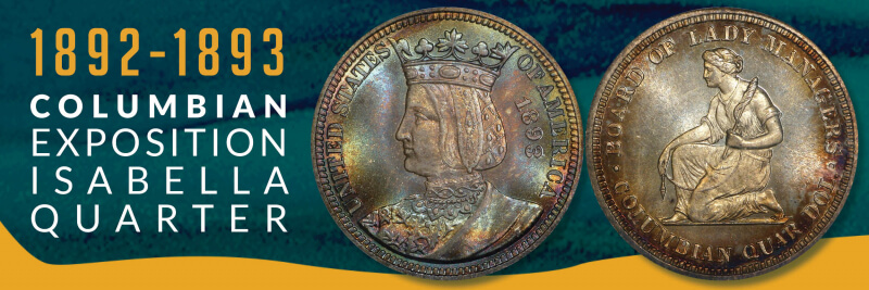
1893 Queen Isabella Commemorative Quarter. (Image via me)
A few things I’ve picked up from researching early commemorative coins:
The people behind them always hope they can raise a ton of money for a pet project or monument or expo. They rarely do.
The designs usually get denigrated by the numismatic press – oftentimes with a venom critics reserve for Limp Bizkit albums or Michael Bay movies.
The mint melts down the excess/unsold coins. As a result, the ones that did sell end up becoming valuable decades later – screwing over collectors on a budget like yours truly.
Those issues were all in play for the 1893 Isabella Quarter.
The Queen Isabella commemorative quarter traces its beginnings to the World’s Fair: Columbian Exposition, held in Chicago in 1893. Congress had already authorized the minting of a commemorative half dollar featuring Christopher Columbus, but a group of women, led by Bertha Palmer, whose husband, Potter, owned the famed Palmer House hotel in Chicago, thought they could do better.
Spearheaded by renowned women’s rights activist, and future $1 coin subject, Susan B. Anthony, the Board of Lady Managers had been awarded $10,000 in federal funds to help manage the Columbian Expo. In early 1893, the Board went before the House Appropriations Committee to ask that the $10,000 could be paid to them in the form of 40,000 specially designed commemorative quarters, which they could then sell at a profit. Congress obliged and the Board set about becoming “the authors of the first really beautiful and artistic coin that has ever been issued by the government of the United States.”
Obviously, the Board wanted a female on the obverse and decided on Queen Isabella I of Castile, who had provided vital financial support for Columbus’s voyages. Putting a foreign monarch on U.S. currency was unprecedented (indeed, there had a been a revolution over it), but according to Coin Week, the main source of conflict was over design.
Caroline Peddle, a former student of famed artist and coin designer Augustus Saint-Gaudens, was hired by the Board to design the coin. However, her sketches, which included a seated Isabella on the obverse and the inscription “Commemorative coin issued for the Board of Lady Managers of the World’s Columbian Exposition by Act of Congress, 1492–1892” on the reverse, were deemed to look too token-like and rejected. Rather than be allowed to redesign the coin, the Mint took away the reverse side and gave it to one of their in-house artists, Charles Barber, to design.
After some more back-and-forth and additional restrictions imposed by the Mint, Peddle resigned. The Mint then cobbled together some portraits of Isabella and ultimately produced an image of a young Isabella wearing a crown on her head for the obverse. On the reverse, the Mint went with an image of a woman kneeling while holding a distaff and spindle- symbolizing her industry. The Board had suggested an image of the Woman’s Building at the Expo, and Palmer later stated that the Board disliked the Mint’s reverse image because “we did not consider [it] typical of the woman of the present day.” However, the Mint made the final decision and approved the coin design.
To say that the reception for the commemorative quarter was not warm is a bit like saying that the American public didn’t embrace Apple’s Newton. The American Journal of Numsimatics was particularly brutal:
[W]e do not know who designed it, but in this instance, as in the half dollar, the contrast between examples of the numismatic art of the nation, as displayed on the Columbian coins, on the one hand, and the spirited and admirable work of the architects of the buildings, for instance, on the other, is painful. If these coins really represent the highest achievements of our medalist and our mints, under the inspiration of an opportunity without restrictions, the like of which has never been presented hitherto in the history of our national coinage, we might as well despair of its future…
The American Journal of Numismatics in October 1893, quoted by PCGS.
The Journal also drew a “mournful” comparison between the reverse design of the kneeling woman holding the distaff and spindle and the well-known “Am I Not a Woman and a Sister?” anti-slavery Hard Times Token. Surely, the Board felt vindicated by that line – although there’s no evidence Palmer or anyone else affiliated with them ever wrote to the Mint to say: “See? I told you we should gone with the building on the reverse.”
1838 HT-81 “Am I Not A Woman & A Sister?” (Image via me)
Sales figures, meanwhile, were disappointing. Of the 40,000 coins minted, a little more than half (21,180) ended up selling. According to NGC, the quarter’s sales were cannibalized by the Columbian Expo half dollar, which sold for the same price and was more widely available at the fair (5 million Columbian Expo half dollars were minted – 125 times as many compared to the Isabella quarter). While it didn’t come close to selling out, Coin Week points out that the quarters, which sold for $1 each, ended up being profitable for the Board. A $20,000-plus stream of revenue may not have been much, but it was double the original federal appropriation awarded to the Board. Of the remaining 19,000-plus quarters, approximately 15,000 went back to the Mint for melting.
1893 Columbian Expo Half Dollar. (Image via me)
In recent years, the coin’s reputation has been rehabilitated and has become a highly sought-after collector’s item. Contemporary reviewers have praised its quaint design and its uniqueness among U.S. commemorative coins (until the modern commemoratives came around, it held the distinction as the only commemorative quarter in U.S. history – as well as the only one to depict a foreign monarch). Even the reverse of the coin has been somewhat vindicated. Art historian Cornelius Vermeule argued that the design wasn’t necessarily evocative of the anti-slavery token and even traced elements of it back to antiquities. “[S]ome details of drapery to a servant girl from the East Pediment of the Temple of Zeus at Olympia, work of about 460 B.C. with additions and revisions in the first or second centuries A.D.,” he wrote.
I love the design and how it distinguishes this coin from other early commemoratives. Too many coins from that era have a generic male bust on the obverse and either an eagle or state symbol on the reverse. Because of the relative scarcity of this coin, buying one wasn’t cheap (this one had been cleaned, which lowered its value, but it still ended up costing over $100). The price tag was worth it, as this has become one of my favorite coins.
So I guess the lesson here is that I should buy more modern commemoratives – even those that I think are ugly. After all, maybe they’ll skyrocket in value in 100 years…
hace 8 horas — Más que un ornamento, el escudo de León XIV es una declaración de principios: unidad, espiritualidad encarnada y una vocación marcada por el ...
hace 11 horas — Como miembro de la Orden de San Agustín desde 1977 y habiendo sido prior general de la misma, León XIV es el primer pontífice agustino en la ...
hace 3 días — La imagen fue tomada el 28 de agosto de 2004 en la parroquia San Agustín, ubicada en el barrio porteño de Recoleta, durante una celebración ...
hace 2 horas — Es el segundo papa de procedencia americana así como también es el primer papa perteneciente a la Orden de San Agustín. Pese a que Eugenio IV y otros ...
hace 3 días — El nuevo Papa elegido este jueves, León XIV, es el primer agustino en dirigir la Iglesia católica. Como indica su nombre, la orden sigue la ...
hace 2 días — El Vaticano publica el escudo oficial del Papa León XIV, vinculado a San Agustín. El escudo pontificio conserva la forma y los elementos ...


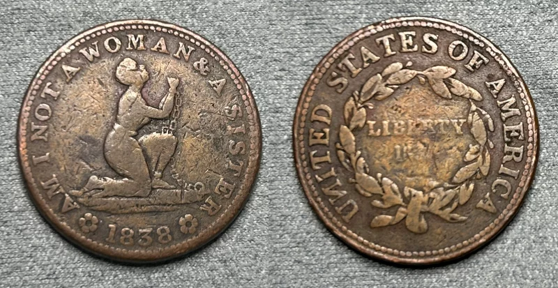 1838 HT-81 “Am I Not A Woman & A Sister?” (Image via me)
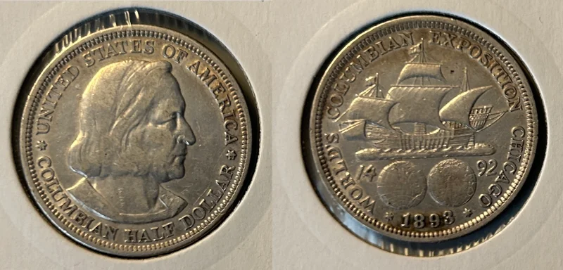 1893 Columbian Expo Half Dollar. (Image via me)