|
|
General: ARIZONA(EEUU)=TIERRA ROJA=PARALELO 33=PHOENIX=SANTO GRIAL=ORION
Choose another message board |
|
Reply |
Message 1 of 21 on the subject |
|
|
|
|
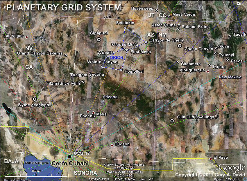
Arizona Orion Correlation (left) and constellation reversed 180 degrees (right).
|
|
|
|
The belt stars correspond to Third, Second, and First Mesas. The distance between Betatakin and Canyon de Chelly is stretched about 12 miles in relation to the constellation; the distance between Walnut Canyon and Homolovi is stretched about 10 miles--not bad, considering it's over 110 miles between Betatakin in the north and Homolovi in the south.
|
|
|
Solstice relationships between villages. Read more about the Arizona Orion Correlation in my book The Orion Zone.
|
|
|
|
Aries, Taurus, Orion, and Canis Major correlations in the American Southwest.
|
|
|
Arizona-New Mexico-California map with Star Hexagon.
Read more in my new book The Kivas of Heaven.
|
|
|
The red dot at the center of the Flower of Life is called the Tuuwanasavi, literally "sand-middle." It is is conceptualized as the Center-place,
the spiritual heart of the Hopi cosmos. This sandy plain is actually located about 4 miles south-southwest of the village of Oraibi on Third Mesa.
In the ancient Egyptian cosmogony, a similar spot corresponds to the Primordial Mound rising from the Ocean of Creation, where the temple at Heliopolis was later constructed. This axis mundi housed the conically shaped, meteoric benben stone, upon which the Bennu bird (phoenix) perched. The inner rectangle (above) is comprised of four loci: (1) Betatakin / Keet Seel (Navajo National Monument), (2) Canyon de Chelly National Monument (which jointly form the base of the Orion projection on the Arizona desert and run along the northeastern escarpment of Black Mesa), (3) Sunset Crater National Monument (a volcano that erupted in 1064 AD), and (4) a point about 18 miles south of Homolovi Ruins State Park, which is located on the right arm of the terrestrial Orion as it reaches southward toward the ancient Hohokam territory in the Phoenix Basin. It's too bad that the Flower of Life doesn't pass through Las Vegas, as it would likely improve the luck of those taking advantage of Vegas vacation packages!
|
|
|
|
Overlaid on the hexagon / cube and the Flower of Life is Solomon's Seal (Star of David), composed of two interlocking equilateral triangles.
|
|
|
Winter solstice sunrise lines (parallel) extend from the Arizona Orion Correlation to both Roswell and Trinity Site in New Mexico.
A summer solstice sunrise line extends from First Mesa, Arizona, through Canyon de Chelly and terminates at the Dulce site.
Read more in my new book The Kivas of Heaven.
|
|
|
Canis Major (Great Dog) superimposed on a Google Earth shot of New Mexico.
Sirius, the brightest star in the heavens, corresponds to Chaco Canyon, the largest Ancestral Puebloan ruin site in the American Southwest.
Gary David's books contend that the Chichimecs (literally "Sons of the Dog") lived in Chaco Canyon and perhaps constructed the pueblos there,
before they migrated southward in the 13th century AD to become the Aztecs in the Valley of Mexico.
Read more in my new book The Kivas of Heaven. It's a great read the next time you're at all inclusive resorts in Jamaica!
|
|
|
About 45 miles south of Ajo, Arizona, on the U.S.-Mexico border is Vertex 17 of the Becker-Hagens "Earthstar" Planetary Grid System.
This grid point is one of 62 major vertices of the mercator-based hexakis icosahedron projected on the Earth globe. With 120 faces, 180 edges,
and 62 vertices, the hexakis icosahedron can be conceptualized as a giant earth-crystal. Coordinates for Cerro Cubabi: 31.72° N, 112°.80W.
Two great circles enclose the Arizona Orion Correlation: an orange “Yang” great circle and a lime-green “Balance” great circle.
This respectively represents Orion's characteristic male, or yang, energy and the Hopi ceremonial cycle that functions to keep the Earth in balance.
Articles by Prof. Bethe Hagens. |
|
|
|
|
This Golden Mean spiral starts at the Throat chakra located at Grand Falls, arcs through the San Francisco Peaks (home of the kachinas, or katsinam), sweeps by the Hopi villages of Oraibi, Shungopovi, and Walpi (the Belt), intersects Orion's right hand, circles into the Hyades horns, and passes through Gamma Tauri.
|
This Golden Mean spiral starts at the Sipapuni (Hopi "Place of Emergence"), arcs through Oraibi (oldest continuously inhabited community on the continent, settled c. A.D. 1100), swings through the Third Eye chakra of Orion at Walnut Canyon, then continues its sweep through the middle of the horns of Taurus.
|
For more on the Golden Mean Spiral, read "Spiral Gate: The Arc of the Covenant"
|
|
The Arizona Orion Correlation's upper part is oriented southwest. The left arm extends from Bellatrix/Wupatki Ruin toward Grand Canyon. It passes Hopi Point on the South Rim, and terminates within the canyon near a butte named Osiris Temple. It celestially corresponds to Pi 3 Orionis.
The Sipapuni (Sípàapuni), or Hopi "Place of Emergence," is a travertine (limestone) dome located on the north bank of the Little Colorado River.
Specifically, it corresponds to Pi 5 Orionis. However, the possible exoplanet status of Pi 3 Orionis and the wormhole nature of the Sipapuni
jointly represent the general function of Grand Canyon in Hopi cosmology. The Hopi perhaps see the Sipapuni as the most sacred spot on Earth.
|
|
|
Looking towrd the southeast, we see the location of the ancestral Hopi ruin site of Wupatki National Monument (corresponding to Bellatrix,
left shoulder of the Ari-zona Orion Correlation). The San Francisco Peaks, home of the Hopi kachinas from July until December, are a few miles
to the south. The Hopi Mesas are over 50 miles northeast of Wupatki. The Sipapuni is located on the Little Colorado River 3.5 miles upstream
from its confluence with the Colorado River. Osiris Temple (corresponding to Pi 3 Orionis) is downstream on the north bank of the Colorado River.
The ancient Egyptians associated Osiris with Orion. Today some people believe that a "Lost City of the Dead," was once located in Grand Canyon. It was reputedly found in 1909 by G.E. Kincaid on an expedition for the Smithsonian Institution. He described it as being filled with ancient Egyptian artifacts, mummies, and hieroglyphics as well as some Asian artifacts. Other people believe the complex is still there, waiting to be rediscovered.
|
|
|
1. Base Chakra = Mesa Verde, the Sun (Orion) Temple in southwestern Colorado.
2. Sacral Chakra = Burnt Corn Ruins near the village of Pinon, Arizona (corresponding to the Orion Nebula).
3. Solar Plexus (Navel) Chakra = Second Mesa and the Hopi village of Shongopovi.
4. The Heart Chakra = Kachina Points, a mesa southwest of Oraibi (also called Monument Point).
5. Throat Chakra = Grand Falls on the Little Colorado River.
6. Third Eye (Pineal) Chakra = Walnut Canyon Ruins in the foothills of the San Francisco Peaks.
7. Crown Chakra = Tuzigoot Ruins and the red rock country of Sedona in Verde Valley.
|
|
|
|
Orion Correlation and adjacent constellations projected upon the American Southwest.
|
|
|
Crown: Alexandria (Pharos Lighthouse) 29° 53’ E
Third Eye: Great Pyramid, Giza, Egypt 31° 09’ E
Throat: Napta Playa, southern Egypt 30° 42’ E
Heart: Rwenzori Mountains, Uganda 29° 57’ E
Solar Plexus: Great Zimbabwe, Zimbabwe 30° 56’ E
Sacral: Mapungubwe, South Africa 29° 22’ E
Root: Boomplaas, South Africa 30° 24’ E
Prime Meridian: about 30° east longitude. Distance between Giza and Boomplaas: over 3,800 miles!
For a description of Napta Playa, the world’s oldest astronomical observatory, see Thomas G. Brophy, The Origin Map.
The Zulu sangoma (shaman) Credo Mutwa states that creatures from a certain star in Orion built an ancient subterranean city of copper in the Rwenzori Mts. ("Mountains of the Moon"), located on the border between Uganda and the Democratic Republic of Congo.
Great Zimbabwe in southern Zimbabwe (formerly Rhodesia) is 320 miles south of the Zambezi River, 1270 – 1550 AD, population c. 18,000. At this eponymous site the roofless oval structure of the "Great Enclosure" is 800 ft long. Its mortar-less granite walls are 30 ft. high and 20 ft. thick at the base. Small monoliths on top of the eastern arc of the Great Enclosure align with three stars in the constellation Orion: Bellatrix, Alnilam, and Saiph shortly before sunrise on winter solstice.
Mapungubwe on the Limpopo River in northern South Africa, 900 – 1300 AD, population c. 5,000.
For a description of Boomplaas (“Tree Farm”) Petroglyph Site in Mpumalanga Provence of South Africa, see Appendix 1 by Rob Milne in my book Eye of the Phoenix.
Read a chapter about South Africa in my new book The Kivas of Heaven.
|
|
|
|
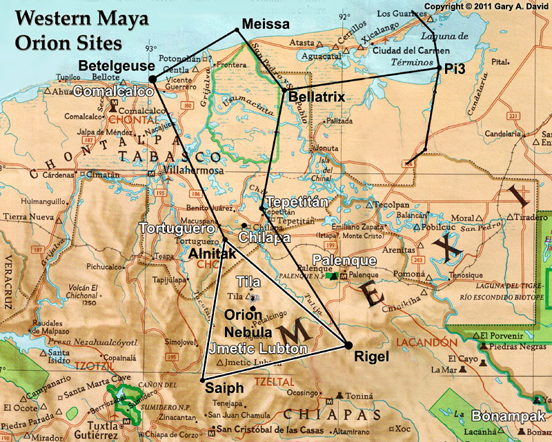
This possible Orion Correlation is located in the Mexican states of Tabasco and Chiapas. Tortuguero corresponds to Alnitak. (The Great Pyramid at Giza and Hopi First Mesa in Arizona also mirror this belt star.) Chilapa corresponds to Alnilam (the middle belt star), and Tepetitán corresponds to Mintaka. Comalcalco corresponds to Betelgeuse, but perhaps only symbolically so. This Maya city that burgeoned between 700 and 900 AD is unique because its pyramids are constructed of kiln-fired bricks. Moreover, many of the mud bricks had been inscribed with Mayan glyphs, but over 500 of them contain various foreign scripts, such as Phoenician, Egyptian, Libyan, Tifinagh, Chinese, Burmese, and even Ogam.
Jmetic Lubton, which corresponds to Saiph, was a ceremonial city with a carved sculpture of what in Tzotzil means “Our Mother Tired Rock.” The famous Maya site of Palenque corresponds to Rigel. However, even if that apex of the constellation is moved north to coincide with the actual site, we still have Tila/Orion Nebula at the center of the three Mayan hearthstones.
According to National Geographic photographer Stephen Alvarez, the Maya hold a ceremony at Tila dedicated to a black earth god, perhaps Ek Chuuah or God M/L. “Every June [solstice?] thousands and thousands of people crowd into the Chiapas town of Tila to see the Black Christ which hangs in the Catholic church in town. The town more than triples in size during the pilgrimage. Maya scholars have told me that the Black Christ is an embodiment of a Maya earth lord and that the blending of Catholic and Maya traditions is a prime example of syncretic religion.”
The stele known as Monument 6 at Tortuguero, Mexico, contains the only known reference carved in stone
of the end of the 13th Baktun--that is, December 21, 2012 !
Read more in my new book The Kivas of Heaven.
|
 Primer Anterior 2 a 2 de 2 Siguiente Primer Anterior 2 a 2 de 2 Siguiente  Último Último |
|
|
|
|
Reply |
Message 2 of 21 on the subject |
|
HOPI EN ARIZONA (TIERRA ROJA Y EN EL PARALELO 33)-NEXO CON ORION
Haz hecho público que te gusta. Deshacer
|
|
|
|
www.youtube.com/watch?v=0MfpWDP_xyM4 Oct. 2011 - 6 min. - Subido por aReaganDesignee
A collection of clips about ancient civilizations and their fascination/tracking of the stars Orion & Sirius. See ...
|
|
|
|
|
www.youtube.com/watch?v=w4KbkyxYs_g20 Nov. 2011 - 4 min. - Subido por lucianaoti01
PLEASE READ BELOW: I think we can now theorize that with the evidence at hand gathered from the Catholic ...
|
|
|
|
|
www.dailymotion.com/.../xbtxqr_the-hopi-nation-the-...12 Ene. 2010 - 8 min.
Links to Pari's articles can be found at:http://globalbrahmakumaris.weebly. comThis video has to be seen ...
|
|
|
|
|
www.youtube.com/watch?v=VGUMorQW3Oo23 Nov. 2011 - 98 min. - Subido por ResistNWOrder
Gary A. David Interview ~ Ancient Hopi Starlore, Orion Zone, Prophecy Author of - The Kivas of Heaven ...
|
|
|
|
|
Reply |
Message 3 of 21 on the subject |
|
|
|
Winter solstice sunrise lines (parallel) extend from the Arizona Orion Correlation to both Roswell and Trinity Site in New Mexico.
A summer solstice sunrise line extends from First Mesa, Arizona, through Canyon de Chelly and terminates at the Dulce site.
Read more in my new book The Kivas of Heaven.
|
|
|
Canis Major (Great Dog) superimposed on a Google Earth shot of New Mexico.
Sirius, the brightest star in the heavens, corresponds to Chaco Canyon, the largest Ancestral Puebloan ruin site in the American Southwest.
Gary David's books contend that the Chichimecs (literally "Sons of the Dog") lived in Chaco Canyon and perhaps constructed the pueblos there,
before they migrated southward in the 13th century AD to become the Aztecs in the Valley of Mexico.
Read more in my new book The Kivas of Heaven.
|
|
|
About 45 miles south of Ajo, Arizona, on the U.S.-Mexico border is Vertex 17 of the Becker-Hagens "Earthstar" Planetary Grid System.
This grid point is one of 62 major vertices of the mercator-based hexakis icosahedron projected on the Earth globe. With 120 faces, 180 edges,
and 62 vertices, the hexakis icosahedron can be conceptualized as a giant earth-crystal. Coordinates for Cerro Cubabi: 31.72° N, 112°.80W.
Two great circles enclose the Arizona Orion Correlation: an orange “Yang” great circle and a lime-green “Balance” great circle.
This respectively represents Orion's characteristic male, or yang, energy and the Hopi ceremonial cycle that functions to keep the Earth in balance.
Articles by Prof. Bethe Hagens. Professor Hagens is currently a member of faculty in the Individualized Bachelors of Arts program at Goddard College as well as a member in Public Policy and Administration at Walden University which offers college online for a broader access to education. |
|
|
|
|
This Golden Mean spiral starts at the Throat chakra located at Grand Falls, arcs through the San Francisco Peaks (home of the kachinas, or katsinam), sweeps by the Hopi villages of Oraibi, Shungopovi, and Walpi (the Belt), intersects Orion's right hand, circles into the Hyades horns, and passes through Gamma Tauri.
|
This Golden Mean spiral starts at the Sipapuni (Hopi "Place of Emergence"), arcs through Oraibi (oldest continuously inhabited community on the continent, settled c. A.D. 1100), swings through the Third Eye chakra of Orion at Walnut Canyon, then continues its sweep through the middle of the horns of Taurus.
|
|
|
The Arizona Orion Correlation's upper part is oriented southwest. The left arm extends from Bellatrix/Wupatki Ruin toward Grand Canyon. It passes Hopi Point on the South Rim, and terminates within the canyon near a butte named Osiris Temple. It celestially corresponds to Pi 3 Orionis.
The Sipapuni (Sípàapuni), or Hopi "Place of Emergence," is a travertine (limestone) dome located on the north bank of the Little Colorado River.
Specifically, it corresponds to Pi 5 Orionis. However, the possible exoplanet status of Pi 3 Orionis and the wormhole nature of the Sipapuni
jointly represent the general function of Grand Canyon in Hopi cosmology. The Hopi perhaps see the Sipapuni as the most sacred spot on Earth.
|
|
|
Looking towrd the southeast, we see the location of the ancestral Hopi ruin site of Wupatki National Monument (corresponding to Bellatrix,
left shoulder of the Ari-zona Orion Correlation). The San Francisco Peaks, home of the Hopi kachinas from July until December, are a few miles
to the south. The Hopi Mesas are over 50 miles northeast of Wupatki. The Sipapuni is located on the Little Colorado River 3.5 miles upstream
from its confluence with the Colorado River. Osiris Temple (corresponding to Pi 3 Orionis) is downstream on the north bank of the Colorado River.
The ancient Egyptians associated Osiris with Orion. Today some people believe that a "Lost City of the Dead," was once located in Grand Canyon. It was reputedly found in 1909 by G.E. Kincaid on an expedition for the Smithsonian Institution. He described it as being filled with ancient Egyptian artifacts, mummies, and hieroglyphics as well as some Asian artifacts. Other people believe the complex is still there, waiting to be rediscovered.
|
|
|
|
|
Reply |
Message 4 of 21 on the subject |
|
The Mayans are very specific in their views about Orion, they consider it to be a point of all creation. In 3114 B.C., they believe these gods came in a convention. This site is linked to the Giza calculations of the pyramids and many wonder how these people thousands of miles apart gained these same mathematical stats of advanced alignments.

ARIZONA, BLACK MESA
Once called Mesa de las Vacas or “Mesa of the Cows” (likened to the Cult of HATHOR)…this place reminds me of the Hopi prophecies of the ‘sky gods’. The Native American tribe of the Hopi’s have called this place home for over a millennium. Some archeologists believe the mythology and design of their structures are centered around the Orion constellation. There are specifically three Hopi mesa’s (1st, 2nd, 3rd) which together form the shape of Orion’s Belt. Collectively others form the entire shape of the entire Orion Constellation.
NEW MEXICO, SANTA FE

Superimposing a map of Orion over this area reveals that Canis Major (Great Dog).
Mexico


NAZCA
Recent research by Phillis Pitluga, a senior astronomer with Chicago’s Adler Planetarium, has demonstrated that the spider, like the Great Pyramids at Giza in Egypt was designed as a terrestrial image in the waist of the spider is of the constellation of Orion. Not only does this spider reflect the Orion Constellation, but its extended arm points to the star SIRIUS.
The straight lines that pass through the geoglyph have been said to point to various directions that the stars of Orion have risen over the local horizon for many, many centuries. The aerial photograph of the spider has white dots placed when the ‘stars of Orion’ have been superimposed over it in the way that some theories have contended. “Mystery on the Desert” by Maria Reiche
http://www.morien-institute.org/nazca8.html
|
|
|
|
Reply |
Message 5 of 21 on the subject |
|
|
|
|
Reply |
Message 6 of 21 on the subject |
|
PROYECTO BIOSFERA II (MUY CERCANO AL PARALELO 33)
Biosfera 2
De Wikipedia, la enciclopedia libre
“Biosfera 2” es una estructura de 1,27 hectáreas[1] (3,15 acres) originalmente construida para formar un ecosistema artificial cerrado en Oracle, Arizona (EE. UU.) por Space Biosphere Ventures, compañía que cuenta como principales delegados con John Polk Allen y Margret Augustine. Construida entre 1987 y 1991, fue diseñada para comprender el complejo entramado de interacciones en un ecosistema, así como para estudiar la viabilidad de biosferas cerradas en la colonización espacial y permitir el estudio y manipulación de una biosfera sin dañar la Tierra. Su nombre se debe a estar modelada sobre una primera biosfera: nuestro ecosistema terrestre. Se financió principalmente a través de la compañía Edward Bass. El proyecto costó 200 millones de dólares y se prolongó de 1985 a 2007.
Con un tamaño similar al de dos campos y medio de fútbol, constituyó el mayor ecosistema cerrado jamás construido. La naturaleza hermética de la estructura permitió a los científicos monitorizar la química del aire, el agua y la tierra contenida en ella. Asimismo, un equipo médico efectuó un seguimiento continuo del estado de salud de la tripulación humana.
En su interior había una selva de 1900 m², un océano de 850 m² con un arrecife de coral, un manglar de 450 m², 1300 m² de sabana, un desierto de 1400 m², 2500 m² de tierras cultivables, un hábitat humano con alojamiento y oficinas, y ciertas instalaciones técnicas bajo tierra. Calefacción y agua fría circulaban por sistemas de tuberías independientes, y la energía eléctrica era proporcionada por una central de gas natural.
En 2006 la estructura dejó de ser hermética y la finca, situada en una zona de ciudades dormitorio alrededor de Tucson, fue propuesta para su urbanización y conversión en futura comunidad residencial.[2]
El 5 de junio de 2007, la propiedad, incluidas tierras circundantes con una extensión de 668 ha (1650 acres), fue vendida a una promotora de casas residenciales por 50 millones de dólares. Parte del terreno sería destinado a viviendas y a un hotel turístico. La reserva, no obstante, permanecería abierta para su exhibición.[3]
El 26 de junio de 2007, la Universidad de Arizona anunció que continuaría con la investigación en Biosfera 2. La noticia acabó con el miedo a la destrucción del famoso terrario de cristal. Responsables de la Universidad comunicaron que gracias a donaciones privadas y becas podrían financiar tanto la investigación como los costes operativos por un espacio de tres años, prorrogables a diez.[4]
Antes de Biosfera se llevaron a cabo tres pequeñas misiones en el Módulo de Pruebas (Test Module o TM), de tamaño bastante menor. Los objetivos de estas pruebas fueron bastante modestos, siendo uno de los más importantes el ensayo del sistema de reciclado de residuos.
John Polk Allen permaneció tres días en el TM; más tarde, Abigail Alling estuvo cinco; y, finalmente, Linda Leigh marcó un nuevo récord mundial con una permanencia de tres semanas. Estas pequeñas misiones fueron, obviamente, demasiado cortas para tan siquiera intentar la cría de animales o el cultivo. Tampoco se recogieron en ellas datos que pudieran ser de utilidad para estimar la capacidad de Biosfera a la hora de mantener a ocho personas durante dos años.
La primera misión en cuarentena duró desde el 26 de septiembre de 1991 hasta el 26 de septiembre de 1993. La tripulación la formaron el investigador y médico Roy Walford, Jane Poynter, Taber MacCallum, Mark Nelson, Sally Silverstone, Abigail Alling (quien reemplazó a última hora a Silke Schneider), Mark Van Thillo y Linda Leigh.
Los plátanos se desarrollaron bastante bien en la estructura, constituyendo una importante fuente de alimentos. Otros cultivos que se incluyeron fueron batatas y cacahuetes. Con todo, los tripulantes denunciaron una continua sensación de hambre al no haber sido capaces de cultivar suficiente comida para ocho personas, que llevaban, además, un estilo de vida ajetreado.
Apareció además otro problema. Durante la primera misión, el oxígeno en el interior de la estación decreció a ritmo constante desde un 20,9% inicial hasta un 14,5% en 16 meses, siendo éste el equivalente al oxígeno disponible a una altura de 4.080 metros. El médico Dr. Roy Walford, miembro de la tripulación, efectuó un seguimiento exhaustivo de los niveles de oxígeno junto con otros doctores del exterior de la Universidad de Arizona, y eventualmente hubo de pedir la adición de oxígeno extra, llevada a cabo hasta en dos ocasiones: el 13 de enero y el 26 de agosto.
Estas complicaciones surgieron en parte motivadas por niveles bajos de luz. El tiempo ese año fue inusualmente nublado, reduciendo la fotosíntesis. Además, las vigas de apoyo de la estructura bloquearon una significativa cantidad de luz, constituyendo así un daño colateral del diseño de la estación.
También surgió la teoría de que la caída de los niveles de oxígeno podría ser debida a la presencia de microbios en el terreno. En las zonas de cultivo, sabana y tropical se inocularon microorganismos con el fin de favorecer el desarrollo de las plantas. Por otro lado, la cantidad de carbono presente en el terreno al comienzo del experimento podría haber sido demasiado elevada, y así los microorganismos estarían consumiendo oxígeno en exceso al convertir el carbono del terreno en dióxido de carbono, utilizando para ello el oxígeno del aire.
No obstante, esta teoría implicaría que los microbios, al consumir tanto oxígeno, habrían de crear cantidades ingentes de dióxido de carbono, por lo que el incremento de CO2 debiera haber sido mayor de lo que se detectó en las lecturas atmosféricas. Más adelante se descubrió que el hormigón de la base de la estructura había estado absorbiendo gran parte de este dióxido de carbono, suavizando así el efecto pernicioso de los microbios en la presencia de oxígeno en el aire.
Según el libro de biología general “Biology”, de Neil Campbell y Jane Reece, Biosfera 2 padeció también de niveles de CO2 “salvajemente variables”, y la mayor parte de las especies vertebradas y todos los insectos polinizadores murieron.
La segunda misión en cuarentena comenzó el 6 de marzo de 1994 con una duración proyectada de diez meses. La tripulación la formaron Norberto Alvarez Romo (capitán), John Druitt, Matt Finn, Pascal Maslin, Charlotte Godfrey, Rodrigo Romo (sin relación con Norberto) y Tilak Mahato.
El 1 de abril graves acusaciones al equipo de dirección provocan su desalojo en cumplimiento de una orden de restricción,[5] quedando la dirección del proyecto a cargo de 'Ed Bass’ Company, Decisions Investment.
A las 3 de la mañana del 5 de abril, Abigail Alling y Mark Van Thillo, miembros de la primera tripulación, sabotearon deliberadamente el proyecto con la apertura de todas las puertas, violando así la cuarentena. Al poco, el capitán Norberto Álvarez Romo, por entonces casado con Margret Augustine, abandonó Biosfera. Fue reemplazado por Bernd Zabel, que ya había sido nombrado capitán de la primera misión pero depuesto a última hora. Dos meses más tarde, Matt Smith reemplazó a Matt Finn.
La compañía Space Biospheres Ventures quedó oficialmente disuelta el 1 de junio. La misión acabaría prematuramente el 6 de septiembre de 1994.
Universidad de Columbia[editar]
En 1995 la dirección de Biosfera 2 fue transferida a la Universidad de Columbia, quien utilizó el complejo como centro de investigaciones en el que sus estudiantes solían pasar un semestre entero. En 2003, Biosfera fue devuelta a sus propietarios originales.
El 10 de enero de 2005 la compañía propietaria de Biosfera 2, Decisions Investments Corporation, anunció la puesta en venta del complejo. En principio se buscaba darle un uso científico, si bien no se excluían compradores con intereses turísticos. En junio de 2007, Associated Press anuncia su venta por 50 millones de dólares a CDO Ranching & Development, L.P.[6] Se construirían 1500 casas y un hotel turístico, si bien la estructura principal se respetaría para la investigación y el uso científico.
Bajo Nueva Administración[editar]
El 26 de junio de 2007, la Universidad de Arizona anuncia que se hará cargo de Biosfera 2, utilizando el enclave como laboratorio para el estudio, entre otras cosas, del cambio climático. La Universidad correrá con los gastos del arrendamiento de la superficie ocupada por Biosfera ante los propietarios. Asimismo, el patrocinador original de Biosfera, Edward P. Bass, donó a la universidad 30 millones de dólares adicionales para el mantenimiento del lugar.[7]

Biosfera 2 por dentro. La vista corresponde a la sabana (en primer plano) y el océano (al fondo).
Al igual que ocurrió con el Proyecto Apollo, Biosfera 2 es más un logro de la ingeniería que de la ciencia. La estructura sobresaliente fue fabricada con tuberías de acero, cristal de alto rendimiento y armazón acerado. El armazón y los cristales fueron diseñados y fabricados por una empresa a cargo de un estudiante de Buckminster Fuller, Peter Pearce (Peter Pearce & Associates). El cierre de las ventanas y las estructuras fue diseñado con el fin de lograr un cierre casi hermético y conseguir así minimizar el flujo de aire, perjudicial para el desarrollo de los experimentos.
Un efecto notable era cómo la estructura se amoldaba a la expansión de la atmósfera interna. Durante el día, el calor del sol provocaba que el aire de dentro se expandiese, mientras que de noche se enfriaba y contraía. Para evitar tener que encargarse de las enormes tensiones que surgirían de mantener un volumen constante, la estructura contaba con unos grandes diafragmas guardados en bóvedas llamadas "pulmones". Éstos permitían a la estructura mantener la presión ambiente en todo momento, sin dejar escapar el aire fuera del hábitat. Esencialmente esto posibilitó que el edificio "creciera" durante el día, y encogiera de noche.
Como la apertura de ventanas no era posible, la estructura también requirió enormes aparatos acondicionadores de aire para controlar la temperatura y evitar la muerte de las plantas del interior. Por cada unidad de energía solar que entraba en la estructura, los acondicionadores debían gastar tres veces más en enfriar el hábitat de nuevo.
Un número especial de la revista Ecological Engineering(Ingeniería Ecológica) editado por B.D.V. Marino y Howard T. Odum en 1999 representa la mayor colección de informes y conclusiones sobre Biosfera 2. Los documentos van desde modelos calibrados describiendo el metabolismo, el balance hidrológico, el calor y la humedad, hasta escritos que hablan de la explotación del bosque tropical, el manglar, el océano y los campos de cultivo en un entorno rico en dióxido de carbono. Los mismos autores escribieron también el libro "Biosphere 2: Research Past and Present (Biosfera 2: Investigación Pasado y Presente)" (ISBN 0-08-043208-5, 330 pp., Elsevier, 1999).
Se ha llegado a decir que en Biosfera 2 se instalaron secretamente purificadores de dióxido de carbono. El hecho de que se añadiese oxígeno y que el suministro eléctrico procediera de gas natural en vez de paneles solares ha suscitado opiniones sobre si esto sería “hacer trampa” o degradaría en algún modo la ciencia que se suponía estaba siendo probada. No obstante, al ser ésta la primera estructura de su tipo, hay también quien considera lógico que fueran necesarios ajustes y alguna adaptación de este complejo sistema.
Psicología y conflictos[editar]
Casi todo lo conocido sobre grupos humanos en aislamiento procede de estudios psicológicos efectuados sobre científicos hibernando en estaciones de investigación en la Antártida. El estudio de este fenómeno se llama “psicología de entorno confinado”, y según Jane Poynter,[8] [9] ésta no fue aplicada correctamente en Biosfera 2.
Antes de que la primera misión en cuarentena alcanzase su ecuador, el grupo ya se había dividido en dos facciones, con antiguos amigos íntimos convertidos en enemigos implacables. Indudablemente, la falta de oxígeno y el bajo suministro de alimentos contribuyeron a minar la moral de todos. La división vino provocada por una disputa entre la tripulación sobre qué era exactamente Biosfera: ¿un experimento científico, una aventura empresarial o quizá sólo una enorme instalación artística? La situación llegó al extremo de que Time Magazine, escribiera:
Ahora, el barniz de credibilidad, ya dañado por acusaciones de manipulación de datos, escondites secretos de comida y suministros de contrabando, se ha roto... El experimento de dos años en autosuficiencia está empezando a parecer menos como ciencia y más como un truco de 150 millones de dólares.
De todos los experimentos, hayan tenido éxito o no, siempre puede extraerse alguna conclusión. En el caso de Biosfera 2, los investigadores aprendieron que los ecosistemas cerrados y pequeños son complejos y vulnerables a eventos no previstos. Esta lección se espera sea aplicable en un futuro al más peligroso entorno del espacio.
Desde un punto de vista empresarial, Biosfera 2 puede ser considerada como un fracaso administrativo. Nunca se pensó que el proyecto llegara a ser rentable, pero sí que podrían costearse algunos de sus enormes gastos suponiendo que 10.000 visitantes al mes pagaran hasta 80 dólares la visita.[11]
Coordenadas:  32°34′43.60″N 110°51′02.14″O / 32.5787778, -110.8505944 (mapa) 32°34′43.60″N 110°51′02.14″O / 32.5787778, -110.8505944 (mapa)
http://es.wikipedia.org/wiki/Biosfera_2
|
|
|
 First
Previous
2 a 6 de 21
Next
First
Previous
2 a 6 de 21
Next Last
Last
|
|
| |
|
|
©2026 - Gabitos - All rights reserved | |
|
|


 Does NASA know more about the star map theory than it cares to mention? Has something conclusive been found on Mars that has inspired a very high risking human journey to it. There have been a lot of internet rumours that NASA is headed by Freemasons. (Try Google word search: Freemason NASA, and decide for yourself). We mention this because there is also 'coincidently' an interesting seven star Freemason 'star map' that the University of Bradford in the UK has revealed. Click the Christos icon and Judas codex icon for more on the Orion secret. Wayne has already officially commented that he will not speak disrespectfully about this society. However we of 'The Hidden Records' research team cannot help questioning the uncanny coincidences that are transpiring here. Is this recognition of the real multi-billion motivation behind the Mars mission?


