Página principal  |  Contacto  

Correo electrónico:

Contraseña:

Registrarse ahora!

¿Has olvidado tu contraseña?

Secreto Masonico
 
Novedades
  Únete ahora
  Panel de mensajes 
  Galería de imágenes 
 Archivos y documentos 
 Encuestas y Test 
  Lista de Participantes
 EL SECRETO DE LA INICIACIÓN 
 Procesos Secretos del Alma 
 Estructura Secreta del Ritual Masónico 
 Los extraños Ritos de Sangre 
 Cámara de Reflexiones 
 
 
  Herramientas
 
General: PROPHECIES OF DANIEL=TRANSFIGURATION=TRAVEL THROUGH TIME=SADRAC MESAC ABED NEGO
Elegir otro panel de mensajes
Tema anterior  Tema siguiente
Respuesta  Mensaje 1 de 44 en el tema 
De: BARILOCHENSE6999  (Mensaje original) Enviado: 18/08/2021 02:04
El emproblemado divorcio de Dan Brown
Origen, la nueva novela de Dan Brown, ya tiene fecha de lanzamiento - La  Tercera
Amazon.com: Dan Brown's Robert Langdon Tetralogy Hardcover Set: Angel's &  Demons / The Da Vinci Code / The Lost Symbol / Inferno (0719534866227): Dan  Brown: Books
Resultado de imagen para DAN BROWN PYRAMID
Resultado de imagen para interes milei javier

Puede ser una imagen de 11 personas y personas sonriendo
Daniel 12:4 (rvr) - Pero tú, Daniel, cierra las palabras y sella...
La Biblia - Daniel - 12:4
Predicación - Daniel, Sadrac, Mesac y Abed Nego - Pastor Joanle Rmz -  YouTube
Sadrac, Mesac y Abed Nego en el Horno de Fuego
Críticas de la película Matrix - SensaCine.com
Resultado de imagen para MARTIN MC LIFE BACK TO THE FUTURE
Imagen relacionada
Resultado de imagen para BACK TO THE FUTURE THREE BROTHERS
Resultado de imagen para LOS TRES PASTORCITOS
Resultado de imagen para travel through time
Resultado de imagen para MEXICO PHI NUMBER GOLDEN NUMBER
Image
Image
the Apple
Resultado de imagen para HAWKING CYGNUS
 
Resultado de imagen para ALDRIN EN ARGENTINA
Resultado de imagen para ALDRIN EN ARGENTINA 16:18 HORA
August 6 THE TRANSFIGURATION OF OUR LORD [Feast] MASS PRAYERS AND READINGS.  - Catholics Striving For Holiness
Desmontando bulos sobre la llegada a la Luna
El cura portugués que no cree en Fátima: "Los pastorcillos fueron  manipulados, las apariciones son mentira"
Resultado de imagen de flower of life freemasonry
Cómo Matrix cambió el cine de ciencia ficción - YouTube


Primer  Anterior  30 a 44 de 44  Siguiente   Último  
Respuesta  Mensaje 30 de 44 en el tema 
De: BARILOCHENSE6999 Enviado: 20/04/2022 02:59
8 Helpful Facts About The 8:8 Lionsgate | Patty Kikos
Resultado de imagen para ROMANTICO
Resultado de imagen para todos los caminos conducen a roma

Resultado de imagen para interes milei javier
Imagen relacionada
Resultado de imagen de FREEMASONRY NUMBER 33
Resultado de imagen para MAQUINA DEL TIEMPO DE VENECIA
ReCreation Thru Coherent Crystal Breathing
Resultado de imagen para Matrix Morpheus


Vesica piscis
TAURO/TORO/PLEYADES/7 COLINAS DEL VATICANO
Image

Fermentation - nigredo - bread and wine of Christ

Image


Image


Image

La vesica piscis (vejiga de pez en latín) es un símbolo hecho con dos círculos del mismo radio que se intersecan de manera que el centro de cada círculo está en la circunferencia del otro. Esta forma se denomina también mandorla (que significa "almendra" en italiano).

Era un símbolo conocido en las antiguas civilizaciones de Mesopotamia, África y Asia.
 
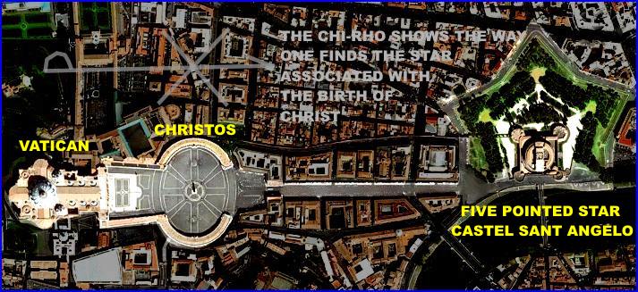
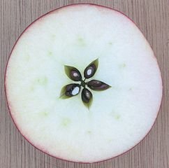
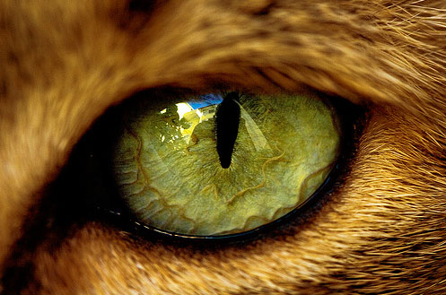
CATOLICO/CAT-OLICO/CAT-EDRAL/CAT/GATO-EL OJO DEL GATO TIENE LA MISMA FORMA QUE LA DEL SEXO FEMENINO "VESCICA PISCIS"
 
C.C. Catch
13/5 (PRIMERA APARICION DE FATIMA)-8/8 (LION S GATE))=88 DIAS EXACTOS
 
13/5-31/5=19 DIAS
 
JUNIO=30 DIAS
 
JULIO=31 DIAS
 
AGOSTO=8 DIAS
 
19+30+31+8=88 DIAS EXACTOS
 
INCLUSO EL PERIODO FATIMA 13/5-13/10=153 DIAS=JUAN 21:11=VESICA PISCIS=OJO DE GATO
 
 
DE TERROR
 
8 Ways to Make Lion's Gate Portal Great (8-8-20) – Chakra Boosters
 
Lion's Gate Opening In Leo: Get Ready for The Shift On August 8th
LXXXVIII finis temporis on Twitter: "BACK TO THE FUTURE codes 8/8 LIONS  GATE PORTAL https://t.co/BLgQp24cbL https://t.co/HffgudFhcL" / Twitter
 
Historia del 13 de mayo: ¿Qué ocurrió en esa fecha?
El cura portugués que no cree en Fátima: "Los pastorcillos fueron  manipulados, las apariciones son mentira"
Santoral de hoy 13 de mayo: Nuestra Señora de Fátima
 
Feline friends: send us your photos | The Murray Valley Standard | Murray  Bridge, SA
International Cat Day 2021- Unknown Facts about the beautiful species of  Cats - YouTube
International Cat Day | Facts From the Stacks
MGM - EcuRed
Metro Goldwyn Mayer despide a su histórico león y lo reemplaza por uno  digital
El nacimiento de la Metro-Goldwyn-Mayer, el primer gran estudio de  Hollywood - Industrias del Cine
Lionsgate (2013-) logo remake by ezequieljairo on DeviantArt
Lionsgate Logo Png - Lionsgate Entertainment Logo Png, Transparent Png ,  Transparent Png Image - PNGitem
Lionsgate toma el 20% de Spyglass Media, la mayor parte de su biblioteca de  200 títulos – Con Pochoclos
Resultado de imagen para NARCISISMO MACHISMO
Happy Cat Day 2021 wishes images for status | 8 August
International cat Day Template | PosterMyWall

Respuesta  Mensaje 31 de 44 en el tema 
De: BARILOCHENSE6999 Enviado: 18/09/2022 03:51
La puerta del sol.docx - [PDF Document]
Tiwanaku Calendar and Sun Gate - YouTube
The Last Supper - Leonardo da Vinci - Zodiac - Astrotheology - The Global  Elite | Gemini and virgo, Last supper, Pisces and taurus
Resultado de imagen para MARS 227000000


22/7=3.14
 
 
¿USTED ES UN NARCISISTA QUE NO CREE EN LA CIENCIA?
Imagen relacionada
Imagen relacionada
Resultado de imagen para MARS 4TH JULY PLANET
 
MOON=RACHEL
YELLOW=JACOB=ISRAEL
RED=BENJAMIN
Resultado de imagen para MARS 4TH JULY PLANET
Resultado de imagen para emmet brown frases
 
Resultado de imagen para BACK TO THE FUTURE THREE BROTHERS
Resultado de imagen para LOS TRES PASTORCITOS
Resultado de imagen de ALBERT EINSTEIN NUMBER PI RELATIVITY
Nuestra Señora de Fátima Y Los Pastorcitos: 13 Mayo -13 Octubre - YouTube
Lucia, Francisco y Jacinta. Los pastorcillos de Fátima - Plan Lector  Editorial Casals -
5 oraciones reveladas en Fátima que todo católico debería conocer
Misterios de Fátima - Wikipedia, la enciclopedia libre
Pastorcitos de la Virgen de Fátima – Misión Fátima
Pin on RIsas de Instagram
Amazon.com: Memorias de la Hemana Lucia Vol. 1: 9789728524227: Lucia de  Jesus, Luis Kondor, Joaquin M. Alonso: Libros
Resultado de imagen para juno temple jupiter capitolino
Elon believes that Earth is doomed to the extent of needing a Noah's Ark  rather than using that time and energy on fixing the problem :  r/EnoughMuskSpam
 
Noah's Ark Turned Up in Kentucky. And Atheists Are Angry - U.S. News -  Haaretz.com
Science and the Bible, Part 7: The Ark on Ararat. - ppt download
The Coming of Noah's 2nd Ark - Home | Facebook
Plantify Vegan Products - Posts | Facebook
 
Musk's plan for 'futuristic Noah's Ark' on Mars trashed by scientists |  Daily Mail Online
Experts May Have Located Noah's Ark's Lost Remains
Noah's Ark hunters claims they've FOUND boat in Turkish mountains as 3D  scans detect 'shape matching Bible description' | The Irish Sun
Real Noah's Ark 'buried in Turkish mountains' and experts say 3D scans will  prove Biblical ship's existence | The Irish Sun
Mirror Now - Referring to Biblical patriarch Noah who... | Facebook
Elon Musk - hurrah - Time Mag Digital Art by James Vaughan | Pixels
Elon Musk Will Build a Futuristic Noah's Ark to Help With Colonizing Mars -  autoevolution
Scientists Criticise Elon Musk's Idea of Creating Futuristic Noah's Ark and  Sending It to Mars
energia cinetica y potencial - Buscar con Google | Energía cinética, Energia  electrica, Tipos de energia
PORQUE EL NARCISISMO ES EL MAYOR ENEMIGO DE CRISTO, MAGDALENA Y JUAN  MARCOS? - DESENMASCARANDO LAS FALSAS DOCTRINAS - Gabitos

Respuesta  Mensaje 32 de 44 en el tema 
De: BARILOCHENSE6999 Enviado: 01/04/2023 17:41


Respuesta  Mensaje 33 de 44 en el tema 
De: BARILOCHENSE6999 Enviado: 24/05/2023 02:32

Utah Elevated: Cathedral of the Madeleine in SLC - YouTube

Jordan River (Utah)


From Wikipedia, the free encyclopedia
 
Jordan River
Proveau's Fork, West Jordan River
Jordan River Dam, 1908-01-28.jpg
Dam at Jordan River Narrows in 1901
Jordan River Utah with locator map.png
Map of the Jordan Subbasin and the location of Salt Lake County in Utah (inset)
Etymology Named after the Jordan River
Location
Country United States
State Utah
Counties UtahSalt Lake
Physical characteristics
Source Utah Lake
 • location Utah CountyUtah
 • coordinates 40°21′34″N 111°53′40″W[1]
 • elevation 4,489 ft (1,368 m)(compromise level)[2]
Mouth Great Salt Lake
 • location Davis CountyUtah
 • coordinates 40°53′52″N 111°58′25″W[1]
 • elevation 4,200 ft (1,300 m)(historical average)[3]
Length 51.4 mi (82.7 km)[4]
Basin size 791 sq mi (2,050 km2)[5]
Discharge  
 • location mouth
 • average 524 cu ft/s (14.8 m3/s)

The Jordan River, in the state of Utah, United States, is a river about 51 miles (82 km) long. Regulated by pumps at its headwaters at Utah Lake, it flows northward through the Salt Lake Valley and empties into the Great Salt Lake. Four of Utah's six largest cities border the river: Salt Lake CityWest Valley CityWest Jordan, and Sandy. More than a million people live in the Jordan Subbasin, part of the Jordan River watershed that lies within Salt Lake and Utah counties. During the Pleistocene, the area was part of Lake Bonneville.

Members of the Desert Archaic Culture were the earliest known inhabitants of the region; an archaeological site found along the river dates back 3,000 years. Mormon pioneers led by Brigham Young were the first European American settlers, arriving in July 1847 and establishing farms and settlements along the river and its tributaries. The growing population, needing water for drinking, irrigation, and industrial use in an arid climate, dug ditches and canals, built dams, and installed pumps to create a highly regulated river.

Although the Jordan was originally a cold-water fishery with 13 native species, including Bonneville cutthroat trout, it has become a warm-water fishery where the common carp is most abundant. It was heavily polluted for many years by raw sewage, agricultural runoff, and mining wastes. In the 1960s, sewage treatment removed many pollutants. In the 21st century, pollution is further limited by the Clean Water Act, and, in some cases, the Superfund program. Once the home of bighorn sheep and beaver, the contemporary river is frequented by raccoonsred foxes, and domestic pets. It is an important avian resource, as are the Great Salt Lake and Utah Lake, visited by more than 200 bird species.

Big CottonwoodLittle CottonwoodRed Butte, Mill, Parley's, and City creeks, as well as smaller streams like Willow Creek at Draper, Utah, flow through the sub-basin. The Jordan River Parkway along the river includes natural areas, botanical gardens, golf courses, and a 40-mile (64 km) bicycle and pedestrian trail, completed in 2017.[6]

Course[edit]

The Jordan River is Utah Lake's only outflow. It originates at the northern end of the lake between the cities of Lehi and Saratoga Springs. It then meanders north through the north end of Utah Valley for approximately 8 miles (13 km) until it passes through a gorge in the Traverse Mountains, known as the Jordan Narrows. The Utah National Guard base at Camp Williams lies on the western side of the river through much of the Jordan Narrows.[7][8] The Turner Dam, located 41.8 miles (67.3 km) from the river's mouth (or at river mile 41.8) and within the boundaries of the Jordan Narrows, is the first of two dams of the Jordan River. Turner Dam diverts the water to the right or easterly into the East Jordan Canal and to the left or westerly toward the Utah and Salt Lake Canal. Two pumping stations situated next to Turner Dam divert water to the west into the Provo Reservoir CanalUtah Lake Distribution Canal, and Jacob-Welby Canal. The Provo Reservoir Canal runs north through Salt Lake County, Jacob-Welby runs south through Utah County. The Utah Lake Distribution Canal runs both north and south, eventually leading back into Utah Lake.[9] Outside the narrows, the river reaches the second dam, known as Joint Dam, which is 39.9 miles (64.2 km) from the river's mouth. Joint Dam diverts water to the east for the Jordan and Salt Lake City Canal and to the west for the South Jordan Canal.[10][11][12]

A map showing the Salt Lake Valley. It shows the locations of the cities inside the valley with mountain ranges on either side of the valley.
Map of the Salt Lake Valley

The river then flows through the middle of the Salt Lake Valley, initially moving through the city of Bluffdale and then forming the border between the cities of Riverton and Draper.[7] The river then enters the city of South Jordan where it merges with Midas Creek from the west. Upon leaving South Jordan, the river forms the border between the cities of West Jordan on the west and Sandy and Midvale on the east. From the west, Bingham Creek enters West Jordan. Dry Creek, an eastern tributary, combines with the main river in Sandy. The river then forms the border between the cities of Taylorsville and West Valley City on the west and Murray and South Salt Lake on the east. The river flows underneath Interstate 215 in Murray. Little and Big Cottonwood Creeks enter from the east in Murray, 21.7 miles (34.9 km) and 20.6 miles (33.2 km) from the mouth respectively. Mill Creek enters on the east in South Salt Lake, 17.3 miles (27.8 km) from the mouth. The river runs through the middle of Salt Lake City, where the river travels underneath Interstate 80 a mile west of downtown Salt Lake City and again underneath Interstate 215 in the northern portion of Salt Lake City. Interstate 15 parallels the river's eastern flank throughout Salt Lake County. At 16 miles (26 km) from the mouth, the river enters the Surplus Canal channel. The Jordan River physically diverts from the Surplus Canal through four gates and heads north with the Surplus Canal heading northwest. Parley's, Emigration, and Red Butte Creeks converge from the east through an underground pipe, 14.2 miles (22.9 km) from the mouth.[7] City Creek also enters via an underground pipe, 11.5 miles (18.5 km) from the river's mouth. The length of the river and the elevation of its mouth varies year to year depending on the fluctuations of the Great Salt Lake caused by weather conditions. The lake has an average elevation of 4,200 feet (1,300 m) which can deviate by 10 feet (3.0 m).[3] The Jordan River then continues for 9 to 12 miles (14 to 19 km) with Salt Lake County on the west and North Salt Lake and Davis County on the east until it empties into the Great Salt Lake.[7][8][11]

Discharge[edit]

The United States Geological Survey maintains a stream gauge in Salt Lake City that shows annual runoff from the period 1980–2003 is just over 150,000 acre-feet (190,000,000 m3) per year or 100 percent of the total 800,000 acre-feet (990,000,000 m3) of water entering the Jordan River from all sources. The Surplus Canal carries almost 60 percent of the water into the Great Salt Lake, with various irrigation canals responsible for the rest. The amount of water entering the Jordan River from Utah Lake is just over 400,000 acre-feet (490,000,000 m3) per year. Inflow from the 11 largest streams feeding the Jordan River, sewage treatment plants, and groundwater each account for approximately 15 percent of water entering the river.[13]

Watershed[edit]

The Jordan River Basin is in northern Utah.
Map of the entire Jordan River Basin


Jordan River
Proveau's Fork, West Jordan River
Jordan River Dam, 1908-01-28.jpg
Dam at Jordan River Narrows in 1901
Jordan River Utah with locator map.png
Map of the Jordan Subbasin and the location of Salt Lake County in Utah (inset)
Etymology Named after the Jordan River
Location
Country United States
State Utah
Counties UtahSalt Lake
Physical characteristics
Source Utah Lake
 • location Utah CountyUtah
 • coordinates 40°21′34″N 111°53′40″W[1]
 • elevation 4,489 ft (1,368 m)(compromise level)[2]
Mouth Great Salt Lake
 • location Davis CountyUtah
 • coordinates 40°53′52″N 111°58′25″W[1]
 • elevation 4,200 ft (1,300 m)(historical average)[3]
Length 51.4 mi (82.7 km)[4]
Basin size 791 sq mi (2,050 km2)[5]
Discharge  
 • location mouth
 • average 524 cu ft/s (14.8 m3/s)
Jordan River (Utah) - Wikipedia
Salt Lake City Map - EXPLAINED - YouTube
Jordan River Crossing into Promised Land, Baptismal Site of Jesus, Qsar al  Yahud | HolyLandSite.com
 
Pin on Travel
Why is the Dead Sea Called the Dead Sea?
How wide and deep was the Jordan River where Israel crossed? | NeverThirsty
Jordan River Parkway Trail | Utah Trails | TrailLink
 
Jordan River source, headwater, tel Dan Paneas, Caesarea philipi 1340 BC
Lot's Wife - A Pillar of Salt

Respuesta  Mensaje 34 de 44 en el tema 
De: BARILOCHENSE6999 Enviado: 30/10/2023 02:04
THE DA TAMAN CODE | Chapter 30
Leonardo's Last Supper • Travel Letter
Las esclusas de los ríos - un invento de Leonardo da Vinci

Respuesta Ocultar Mensaje Eliminar Mensaje  Mensaje 657 de 657 en el tema 
De: BARILOCHENSE6999 Enviado: 29/10/2023 23:00
How the Panama Canal Gate Works: Brilliant Engineering by Leonardo da Vinci  - YouTube
Leonardo da Vinci's GENIUS invention - Miter Locks - YouTube

Respuesta  Mensaje 35 de 44 en el tema 
De: BARILOCHENSE6999 Enviado: 07/12/2023 05:32
Resultado de imagen de flower of life freemasonry
UberFacts on Twitter: "After Marty McFly accidentally knocks down a pine  tree in the past at the site of the future Twin Pines Mall...  http://t.co/tzYaYIsjpc" / Twitter
Pin by Popcorn Label on Favorite Memes | Spinal fluid, Pineal gland, Gland
The Third Eye building is pretty interesting. It is framed directly behind  the Clocktower Lady when she tells Marty the fortune of when the clocktower  would be struck. I believe director Zemeckis
Letra V Del Alfabeto De Oro (símbolo De La Victoria) Ilustraciones Svg,  Vectoriales, Clip Art Vectorizado Libre De Derechos. Image 32994690.
Resultado de imagen para MARTIN MC FLY BABY
Gone With The Wind & The Academy Awards - Hollywood's Massive Golden Gate  Ritual | PeakD
Silver Gate and Golden Gate | Telos
A Silver Gateway on a High Hand | Shamanic Astrology Mystery School
Germanic Astronomy
Germanic Astronomy
Previsualización de la tapa del diario Clarin
Templo san lorenzo by Belen Sïs


EL MITO DE LA CREACIÓN Los olmecas pensaban ser descendientes de una mezcla  entre jaguar, gran depredador de la selva y una mujer humana que dio  nacimiento. - ppt video online descargar
The Four Angels, Corners, and Winds of the Four Elements of God's Creation  | Christian traditions, Angel of the north, Witchcraft books
The Four Archangels of the Elements – Uriel, Gabriel, Raphael, and Michael  | Archangels, Four archangels, Cool symbols
Angels and Demons Tour - Eventland
Illuminating Angels & Demons (Full Documentary) - YouTube
Discover Rome on an Angels and Demons Inspired Walking Tour
A Self-Guided Angels & Demons Tour of Rome by FSM | PDF
Angels and Demons Tour - Eventland
 
Mapa de Ecuador
La Mitad del Mundo incorpora una pirámide ecuatorial Redacción Viajar –  ALNNEWS
ecuador by araceli sotelo
Diario La Hora Loja 22 de Junio 2018 by LA HORA Ecuador - Issuu
Lugares turísticos e históricos de Quito
Paramos el huevo en la Mitad Del Mundo! - #10 Hi Explorers - YouTube
Mitad del mundo, luego de poner el huevo sobre la cabeza de un clavo. -  Mitad Del Mundo, San Antonio de Pichincha Resmi - Tripadvisor
Huevo de gallina de equilibrio en el clavo en su extremo puntiagudo sobre  la línea ecuatorial en el Museo Solar Intinian cerca de Quito, Ecuador  Fotografía de stock - Alamy
La Mitad del Mundo y mi obsesión por las líneas | Patoneando
August 10. St. LAWRENCE, Deacon, Martyr. Feast. Gospel, Commentary, Divine  Office 2nd Reading, And Prayer. - Catholics Striving For Holiness
El 10th de agosto feliz Día de la Independencia de Ecuador diseño con una  bandera Fotografía de stock - Alamy
 
Cinemática - Movimiento relativo a la Tierra
Qué es el efecto Coriolis | Explicación fácil para niños
The Church of Santa Maria della Vittoria in Rome - Walks in Rome (Est. 2001)
 
MARIA DELLA VITTORIA ROME
Día de la Independencia, Ecuador- 10: vector de stock (libre de regalías)  1990770755 | Shutterstock
 
El Sistema Climático Maestría en Geociencias 2022
El Efecto Coriolis:Descripcion del Fenomeno y Causas
En qué consiste el efecto Coriolis? | La respuesta de Trivia |
 
Comprendiendo los remolinos
 
 
Giran todos los remolinos del hemisferio norte en el mismo sentido? –  Aemetblog
Por qué el efecto Coriolis es cero en el ecuador? - Quora

Iglesia de Santa María de la Victoria


Fachada de Santa María de la Victoria.

La Iglesia de Santa María de la Victoria (en italianoSanta María della Vittoria) es una pequeña basílica en Roma (Italia), en la Via XX Settembre.

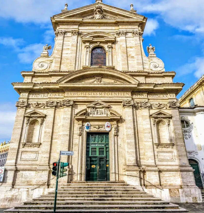
Los Carmelitas descalzos obtuvieron un Breve apostólico de Paulo V para edificar conventos de su Orden en cualquier parte de la Cristiandad; fue este el primero que fundaron en la última parte del Monte Quirinal el año de 1606.

Historia[editar]

La iglesia se fundó en 1605 como una capilla dedicada a san Pablo para los carmelitas descalzos. La propia orden dotó de fondos a la obra del edificio hasta el descubrimiento en las excavaciones de la escultura conocida como el Hermafrodita BorgheseScipione Borghese se apropió de ella, pero a cambio, y quizá para compensar su pérdida de influencia debido a la muerte de su tío y patrón, financió el resto de la obra de la fachada y prestó a la orden a su arquitecto, Giovanni Battista Soria. Estas concesiones, sin embargo, sólo se llevaron a efecto en 1624, aunque la obra se acabó dos años más tarde.

Después de la victoria católica en la batalla de la Montaña Blanca en 1620, que hizo retroceder la Reforma en Bohemia, la iglesia fue consagrada de nuevo a la Virgen María. Una imagen maltrecha había sido recuperada del ámbito de aquella batalla por Fray Domingo de Jesús María, de dicha Orden, de las ruinas de la casa de campo de un noble cristiano bohemio, a la cual se le atribuyó la victoria, llamándola Santa María de la Victoria. La imagen fue llevada a Roma por Fray Domingo, depositándose en Santa María la Mayor en presencia de Gregorio XV.

El nombre de Santa María de la Victoria, se dio ulteriormente, en conmemoración por haber reconquistado el emperador Fernando I la ciudad de Praga en 1671. Estandartes turcos capturados en el Sitio de Viena de 1683 cuelgan en la iglesia, como parte de este tema victorioso.

Vista general[editar]

Arquitectura[editar]

La capilla Cornaro, con el Éxtasis de santa Teresa de Bernini presidiendo el altar, representada en una pintura de Guido Ubaldo Abbatini, 1652 (Staatliche Museum, Schwerin).

La iglesia es la única estructura diseñada y completada por el arquitecto del Barroco temprano, Carlo Maderno, aunque el interior padeció un fuego en 1833 y requirió una restauración. Su fachada, sin embargo, fue erigida por Soria en vida de Maderno (1624-1626), mostrando la inconfundible influencia de la cercana Santa Susanna de Maderno.

Su interior tiene una sola nave, amplia, bajo una bóveda segmentada baja, con tres capillas laterales interconectadas detrás de arcos separados por colosales pilastras corintias con capiteles dorados que apoyan un rico entablamento. Revestimientos de mármol que contrastan entre sí están enriquecidos con ángeles y putti de estuco blanco y dorado en bulto redondo. El interior fue enriquecido progresivamente después de la muerte de Maderno; su bóveda fue pintada al fresco en 1663 con temas triunfales dentro de compartimentos con marcos ficticios: La Virgen María triunfa sobre la Herejía y Caída de los ángeles rebeldes ejecutados por Giovanni Domenico Cerrini.

Obras[editar]

Sin duda, parte de la fama de este templo se debe a albergar una de las obras maestras del Barroco, la capilla Cornaro, espectacular y teatral espacio presidido por el grupo escultórico que representa el Éxtasis de Santa Teresa, de Gian Lorenzo Bernini, quizá la obra más conocida de este autor en el campo de la escultura. En la capilla situada frente a esta, dedicada a San José, se encuentra un grupo escultórico que representa el tema del Sueño de San José, obra del escultor Domenico Guidi, que se inspira en la obra de Bernini delante de la cual se halla.1

Tituli[editar]

Santa María de la Victoria es una iglesia titular. El cardenal presbítero del Titulus S. Mariae de Victoria era el cardenal Giuseppe Caprio hasta su muerte en octubre de 2005. El 24 de marzo de 2006, el papa Benedicto XVI elevó a Seán Patrick O'Malley al titulus.


Respuesta  Mensaje 36 de 44 en el tema 
De: BARILOCHENSE6999 Enviado: 16/01/2024 10:35


Respuesta  Mensaje 37 de 44 en el tema 
De: BARILOCHENSE6999 Enviado: 06/02/2024 03:36


Respuesta  Mensaje 38 de 44 en el tema 
De: BARILOCHENSE6999 Enviado: 04/04/2024 14:59

Respuesta  Mensaje 39 de 44 en el tema 
De: BARILOCHENSE6999 Enviado: 22/04/2024 02:21

Utah Elevated: Cathedral of the Madeleine in SLC - YouTube

Jordan River (Utah)


From Wikipedia, the free encyclopedia
 
Jordan River
Proveau's Fork, West Jordan River
Jordan River Dam, 1908-01-28.jpg
Dam at Jordan River Narrows in 1901
Jordan River Utah with locator map.png
Map of the Jordan Subbasin and the location of Salt Lake County in Utah (inset)
Etymology Named after the Jordan River
Location
Country United States
State Utah
Counties UtahSalt Lake
Physical characteristics
Source Utah Lake
 • location Utah CountyUtah
 • coordinates 40°21′34″N 111°53′40″W[1]
 • elevation 4,489 ft (1,368 m)(compromise level)[2]
Mouth Great Salt Lake
 • location Davis CountyUtah
 • coordinates 40°53′52″N 111°58′25″W[1]
 • elevation 4,200 ft (1,300 m)(historical average)[3]
Length 51.4 mi (82.7 km)[4]
Basin size 791 sq mi (2,050 km2)[5]
Discharge  
 • location mouth
 • average 524 cu ft/s (14.8 m3/s)

The Jordan River, in the state of Utah, United States, is a river about 51 miles (82 km) long. Regulated by pumps at its headwaters at Utah Lake, it flows northward through the Salt Lake Valley and empties into the Great Salt Lake. Four of Utah's six largest cities border the river: Salt Lake CityWest Valley CityWest Jordan, and Sandy. More than a million people live in the Jordan Subbasin, part of the Jordan River watershed that lies within Salt Lake and Utah counties. During the Pleistocene, the area was part of Lake Bonneville.

Members of the Desert Archaic Culture were the earliest known inhabitants of the region; an archaeological site found along the river dates back 3,000 years. Mormon pioneers led by Brigham Young were the first European American settlers, arriving in July 1847 and establishing farms and settlements along the river and its tributaries. The growing population, needing water for drinking, irrigation, and industrial use in an arid climate, dug ditches and canals, built dams, and installed pumps to create a highly regulated river.

Although the Jordan was originally a cold-water fishery with 13 native species, including Bonneville cutthroat trout, it has become a warm-water fishery where the common carp is most abundant. It was heavily polluted for many years by raw sewage, agricultural runoff, and mining wastes. In the 1960s, sewage treatment removed many pollutants. In the 21st century, pollution is further limited by the Clean Water Act, and, in some cases, the Superfund program. Once the home of bighorn sheep and beaver, the contemporary river is frequented by raccoonsred foxes, and domestic pets. It is an important avian resource, as are the Great Salt Lake and Utah Lake, visited by more than 200 bird species.

Big CottonwoodLittle CottonwoodRed Butte, Mill, Parley's, and City creeks, as well as smaller streams like Willow Creek at Draper, Utah, flow through the sub-basin. The Jordan River Parkway along the river includes natural areas, botanical gardens, golf courses, and a 40-mile (64 km) bicycle and pedestrian trail, completed in 2017.[6]

Course[edit]

The Jordan River is Utah Lake's only outflow. It originates at the northern end of the lake between the cities of Lehi and Saratoga Springs. It then meanders north through the north end of Utah Valley for approximately 8 miles (13 km) until it passes through a gorge in the Traverse Mountains, known as the Jordan Narrows. The Utah National Guard base at Camp Williams lies on the western side of the river through much of the Jordan Narrows.[7][8] The Turner Dam, located 41.8 miles (67.3 km) from the river's mouth (or at river mile 41.8) and within the boundaries of the Jordan Narrows, is the first of two dams of the Jordan River. Turner Dam diverts the water to the right or easterly into the East Jordan Canal and to the left or westerly toward the Utah and Salt Lake Canal. Two pumping stations situated next to Turner Dam divert water to the west into the Provo Reservoir CanalUtah Lake Distribution Canal, and Jacob-Welby Canal. The Provo Reservoir Canal runs north through Salt Lake County, Jacob-Welby runs south through Utah County. The Utah Lake Distribution Canal runs both north and south, eventually leading back into Utah Lake.[9] Outside the narrows, the river reaches the second dam, known as Joint Dam, which is 39.9 miles (64.2 km) from the river's mouth. Joint Dam diverts water to the east for the Jordan and Salt Lake City Canal and to the west for the South Jordan Canal.[10][11][12]

A map showing the Salt Lake Valley. It shows the locations of the cities inside the valley with mountain ranges on either side of the valley.
Map of the Salt Lake Valley

The river then flows through the middle of the Salt Lake Valley, initially moving through the city of Bluffdale and then forming the border between the cities of Riverton and Draper.[7] The river then enters the city of South Jordan where it merges with Midas Creek from the west. Upon leaving South Jordan, the river forms the border between the cities of West Jordan on the west and Sandy and Midvale on the east. From the west, Bingham Creek enters West Jordan. Dry Creek, an eastern tributary, combines with the main river in Sandy. The river then forms the border between the cities of Taylorsville and West Valley City on the west and Murray and South Salt Lake on the east. The river flows underneath Interstate 215 in Murray. Little and Big Cottonwood Creeks enter from the east in Murray, 21.7 miles (34.9 km) and 20.6 miles (33.2 km) from the mouth respectively. Mill Creek enters on the east in South Salt Lake, 17.3 miles (27.8 km) from the mouth. The river runs through the middle of Salt Lake City, where the river travels underneath Interstate 80 a mile west of downtown Salt Lake City and again underneath Interstate 215 in the northern portion of Salt Lake City. Interstate 15 parallels the river's eastern flank throughout Salt Lake County. At 16 miles (26 km) from the mouth, the river enters the Surplus Canal channel. The Jordan River physically diverts from the Surplus Canal through four gates and heads north with the Surplus Canal heading northwest. Parley's, Emigration, and Red Butte Creeks converge from the east through an underground pipe, 14.2 miles (22.9 km) from the mouth.[7] City Creek also enters via an underground pipe, 11.5 miles (18.5 km) from the river's mouth. The length of the river and the elevation of its mouth varies year to year depending on the fluctuations of the Great Salt Lake caused by weather conditions. The lake has an average elevation of 4,200 feet (1,300 m) which can deviate by 10 feet (3.0 m).[3] The Jordan River then continues for 9 to 12 miles (14 to 19 km) with Salt Lake County on the west and North Salt Lake and Davis County on the east until it empties into the Great Salt Lake.[7][8][11]

Discharge[edit]

The United States Geological Survey maintains a stream gauge in Salt Lake City that shows annual runoff from the period 1980–2003 is just over 150,000 acre-feet (190,000,000 m3) per year or 100 percent of the total 800,000 acre-feet (990,000,000 m3) of water entering the Jordan River from all sources. The Surplus Canal carries almost 60 percent of the water into the Great Salt Lake, with various irrigation canals responsible for the rest. The amount of water entering the Jordan River from Utah Lake is just over 400,000 acre-feet (490,000,000 m3) per year. Inflow from the 11 largest streams feeding the Jordan River, sewage treatment plants, and groundwater each account for approximately 15 percent of water entering the river.[13]

Watershed[edit]

The Jordan River Basin is in northern Utah.
Map of the entire Jordan River Basin


Jordan River
Proveau's Fork, West Jordan River
Jordan River Dam, 1908-01-28.jpg
Dam at Jordan River Narrows in 1901
Jordan River Utah with locator map.png
Map of the Jordan Subbasin and the location of Salt Lake County in Utah (inset)
Etymology Named after the Jordan River
Location
Country United States
State Utah
Counties UtahSalt Lake
Physical characteristics
Source Utah Lake
 • location Utah CountyUtah
 • coordinates 40°21′34″N 111°53′40″W[1]
 • elevation 4,489 ft (1,368 m)(compromise level)[2]
Mouth Great Salt Lake
 • location Davis CountyUtah
 • coordinates 40°53′52″N 111°58′25″W[1]
 • elevation 4,200 ft (1,300 m)(historical average)[3]
Length 51.4 mi (82.7 km)[4]
Basin size 791 sq mi (2,050 km2)[5]
Discharge  
 • location mouth
 • average 524 cu ft/s (14.8 m3/s)
Jordan River (Utah) - Wikipedia
Salt Lake City Map - EXPLAINED - YouTube
Jordan River Crossing into Promised Land, Baptismal Site of Jesus, Qsar al  Yahud | HolyLandSite.com
 
Pin on Travel
Why is the Dead Sea Called the Dead Sea?
How wide and deep was the Jordan River where Israel crossed? | NeverThirsty
Jordan River Parkway Trail | Utah Trails | TrailLink
 
Jordan River source, headwater, tel Dan Paneas, Caesarea philipi 1340 BC
Lot's Wife - A Pillar of Salt

Respuesta  Mensaje 40 de 44 en el tema 
De: BARILOCHENSE6999 Enviado: 24/05/2024 15:22
Apollo 11 Moon Landing 50th Anniversary — Little Village Toy & Book Shop

Respuesta Ocultar Mensaje Eliminar Mensaje  Mensaje 60 de 60 en el tema 
De: BARILOCHENSE6999 Enviado: 24/05/2024 11:02
July 25: Arch of Constantine | FCIT

Respuesta  Mensaje 41 de 44 en el tema 
De: BARILOCHENSE6999 Enviado: 03/06/2024 13:09

Enviado: 03/06/2024 10:05
MJJJusticeProject Inc- #MJ Fan Acct on X: "Albert Einstein was included in  the famous #MichaelJackson reconstruction of the Last Supper- Michael  admired Einstein's #Philosophy & #Genius - We see why -  https://t.co/YtKqMvLiQm" /
 
Resultado de imagen para CHURCHILL DESTINO
Resultado de imagen para RAMERA PIEDRAS JUAN 8
Moon Phases 50th Anniversary Apollo 11 1969 Moon Landing Tees Digital by  Tony Rubino | Saatchi Art
Luke 8:2 KJV - And certain women, which had been healed of evil
Luke 8:2 And certain women, which had been healed of evil spirits and  infirmities, Mary called Magdalene, out of whom went seven devils,
Bérenger Saunière Priest Wizard of Rennes-le-Chteau - Magers & Quinn  Booksellers
The Cryptogram of Rennes-le-Chateau eBook by Philip Coppens - EPUB Book |  Rakuten Kobo 9781623093860
Rennes-Le-Chteau: The Devil, Treasure & Secrets Of Saunière
RENNES LE CHÂTEAU - L'église Sainte Marie-Madeleine - Asmodeus - National  Tokens
The 7 Devils of Mary Magdalene (The Diamond Legacy Book 4) See more
A moon shaped as letter D in the night sky, astro photography, detailed  texture. : r/dalle2
 
ANGELS & DEMONS - DAN BROWN - SBS Librerias
 
D-MON/MOON (LETTER D)
How to Find Draco the Dragon Constellation - YouTube
The Chris Voss Show Podcast – No Grail Without Dragons: A Man's  Unconventional Path to Love, Purpose, and Peace by Victor J. Giusfredi
Mitología griega - templo de Apolo - YouTube
 
Resultado de imagen para CHURCHILL DESTINO
Resultado de imagen para RAMERA PIEDRAS JUAN 8
Resultado de imagen para EINSTEIN STONE
michaeljacksonlastsupper.jpg
Mont-Saint-Michel - Manche - Medallas
MONT SAINT MICHEL Copper Coin 1$ Cook Islands 2023
 
1BILLET 0 Euro Monte San Michel 1000 Anni Francia Colore 2023 Numero Vari |  eBay
 
Ticket Le Mont Saint Michel 6 Aug 1944 D-Day 2024 Number 0002
Le Mont-Saint-Michel
Visitar MONT SAINT MICHEL. Guía completa. Guía de Francia - YouTube
D-Day」の写真素材 | 10,835件の無料イラスト画像 | Adobe Stock
460+ D Day Ilustraciones de Stock, gráficos vectoriales libres de derechos  y clip art - iStock | Desembarco de normandia
D-Day In Numbers: 4 Infographics That Show The Big Picture | HistoryExtra
D-Day Invasion: Facts and Significance
Prime Video: D-Day
Apollo and the Oracle of Delphi - YouTube
St. Mary Magdalene
Calendario Lunar Julio de 1969 - Fases Lunares
Bible Fun For Kids: Genesis: Joseph's Dreams and His Colorful Coat
 
DREAMS=D-REAMS=LETTER D
We Learned These Tricks at School, and They Still Work / Bright Side
Moon Phases Names - an easy way to remember - Star In A Star
michaeljacksonlastsupper.jpg
Independence Square Maidan Nezalezhnosti with Lyadsky Gate and Gold plated bronze statue of Archangel Michael
Resultado de imagen para TROYE WAR FRANCE
 
 
CHAMPAGNE=TROYES (VERDADERA TROYA)
Resultado de imagen para VIKING TRAVEL THROUGH TIME
Resultado de imagen para VIKING NORMANDY
Resultado de imagen para VIKINGOS NORMANDIA
Resultado de imagen para normandos vikingos
Resultado de imagen para NORMANDIA HANS ETIOPIA ARCA DE LA ALIANZA
Resultado de imagen para EXPERIMENT PHILADELPHIA
Resultado de imagen para NORMANDIA HANS ETIOPIA ARCA DE LA ALIANZA
Resultado de imagen para relatividad numero pi
Resultado de imagen para DE-173  Normandía en 1944
Resultado de imagen para EXPERIMENTO FILADELFIA 28 DE OCTUBRE
 
Resultado de imagen para JUAN 3:14
Resultado de imagen para PI

Día de Nuestra Señora de la Magdalena, 22 de julio

22 de Julio

Respuesta  Mensaje 42 de 44 en el tema 
De: BARILOCHENSE6999 Enviado: 03/06/2024 14:35
 BARILOCHENSE6999 Enviado: 24/05/2024 11:22
Apollo 11 Moon Landing 50th Anniversary — Little Village Toy & Book Shop

Respuesta Ocultar Mensaje Eliminar Mensaje  Mensaje 60 de 60 en el tema 
De: BARILOCHENSE6999 Enviado: 24/05/2024 11:02
July 25: Arch of Constantine | FCIT


Respuesta  Mensaje 43 de 44 en el tema 
De: BARILOCHENSE6999 Enviado: 04/06/2024 12:55
Viking 1
Viking orbiter/lander
 
Mission type Orbiter and lander
Operator NASA
COSPAR ID Orbiter: 1975-075A
Lander: 1975-075C
SATCAT no. Orbiter: 8108
Lander: 9024
Website Viking Project Information
Mission duration Orbiter: 1,846 days  (1797 sols)
Lander: 2,306 days  (2,245 sols)
Launch to last contact: 2,642 days
 
Spacecraft properties
Manufacturer Orbiter: NASA JPL
Lander: Martin Marietta
Launch mass 3,530 kg[a]
Dry mass Orbiter: 883 kg (1,947 lb)
Lander: 572 kg (1,261 lb)
Power Orbiter: 620 W
Lander: 70 W
 
Start of mission
Launch date 21:22, August 20, 1975 (UTC)[2][3]
Rocket Titan IIIE/Centaur
Launch site LC-41Cape Canaveral
 
End of mission
Last contact November 11, 1982[4]
 
Orbital parameters
Reference system Areocentric
 
Mars orbiter
Spacecraft component Viking 1 Orbiter
Orbital insertion June 19, 1976[2][5]
Orbital parameters
Periareion altitude 320 km (200 mi)
Apoareion altitude 56,000 km (35,000 mi)
Inclination 39.3°
Mars lander
Spacecraft component Viking 1 Lander
Landing date July 20, 1976[2]
11:53:06 UTC  (MSD 36455 18:40 AMT)
Landing site 22.27°N 312.05°E[2]
← None
 

Respuesta  Mensaje 44 de 44 en el tema 
De: BARILOCHENSE6999 Enviado: 05/06/2024 14:14

Thanks to Catholicism ♥ — Mary & the EU Flag — Our Lady's Crown
The "Virgin Mary" Euro Flag
264,675 Europe Flag Stock Photos - Free & Royalty-Free Stock Photos from  Dreamstime
163,867 European Flag Stock Photos - Free & Royalty-Free Stock Photos from  Dreamstime
The "Virgin Mary" Euro Flag
Our Lady of the Miraculous Medal and the flag of the European Union  #AnecdotesVF - FAMVIN NewsEN
Comparing Extraterritoriality in the EU - Transnational Litigation Blog
Sacred Geography Enclosed in the Idea of the Apollo-Saint Michael Axis |  ARCHAEOTRAVEL
Saint Michael's line - fabiopetrella
Mont St. Michel, France.
These 7 Christian sanctuaries dedicated to Archangel Michael are perfectly  lined up. The reason will blow your mind! - Travel site
The 7 shrines NOT in a straight line: the Mysterious Faith for St. Michael  the Archangel » Stephen Kleckner's blog
Muere Michael Collins, el astronauta del Apolo 11 que viajó a la Luna con  Neil Amstrong y Buzz Aldrin
Mont St. Michel, France.
Saint Michael-Apollo Axis | ARCHAEOTRAVEL
Sacred Geography Enclosed in the Idea of the Apollo-Saint Michael Axis |  ARCHAEOTRAVEL
Resultado de imagen para michael collins italian BORN ROME
Resultado de imagen para BANDERA ITALIA
Chispas Literarias - Jefe de Chispas Literarias - Chispas Literarias |  LinkedIn
Resultado de imagen de CERN ANGELS DEMONS
OFM Franciscans PH on Twitter: "SAINT MICHAEL'S LENT August 15th-September  29th St. Francis, known for his deep devotion to the Blessed Virgin Mary  and St. Michael the Archangel, Prince of angels and
Daily Mass Tuesday, September 29, 2020 – Feast of Saints Michael, Gabriel,  and Raphael, archangels - YouTube
Today, September 29, We Celebrate Sts. Michael, Gabriel, Raphael, Archangels
September 29, 1954 - CERN Established
CERN established
CERN 50th Anniversary A Photographic Timeline - ppt download
September 29 in history: Isabella II becomes Spanish Queen, CERN  established, and more - Photos News
WION - #TodayInHistory | 1954: European Organization for Nuclear Research,  CERN, is established | Facebook
Accelerating Science and Innovation Welcome to CERN. - ppt download
Que es un acelerador de particulas y para que sirve? El CERN y su LHC. -  YouTube
europeanorganisation - Twitter Search / Twitter
CERN 666 To Be Activated 9/23/2015 | Page 2 | Sherdog Forums | UFC, MMA &  Boxing Discussion
CERN 50 th Anniversary A Photographic Timeline Miguel Angel Marquina  (Editor) CIEMAT/CERN. - ppt download
Six decades of science for peace – CERN Courier
Resultado de imagen para MARS 4TH JULY PLANET
Resultado de imagen para MICHAEL WAR REVELATION 12
Resultado de imagen para MARS 4TH JULY PLANET
Resultado de imagen para MICHAEL WAR REVELATION 12
Resultado de imagen para MARS 4TH JULY PLANET
Resultado de imagen para MICHAEL WAR REVELATION 12
Resultado de imagen para STAR WAR REVELATION 12
Resultado de imagen para REVELATION 12 LAST SUPPER


Primer  Anterior  30 a 44 de 44  Siguiente   Último  
Tema anterior  Tema siguiente
 
©2024 - Gabitos - Todos los derechos reservados