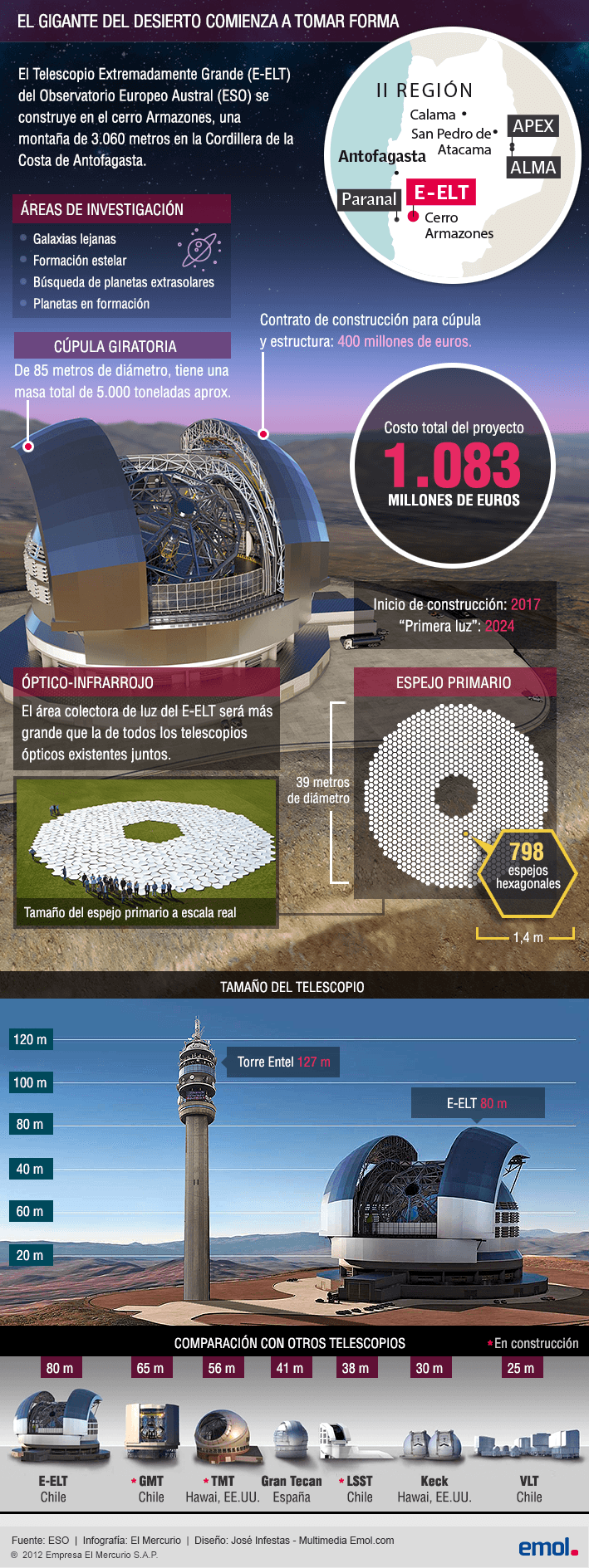
Me hago un lio con las coordenaas esas que pones, una explicación para dummies? me queo toa bizca
Karolina, no son mis coordenadas son las coordenas inherentes a la figura. Vamos a intentar nuevamente, no es dificil pero hay que abstraerse de la logica convencional, en el sentido de que tenemos que entender que todo lo que vemos y tambien lo que no en el universo tiene un equilibrio matematico, desde los atomos, las moleculas, los cristales, los seres vivos, los sistemas solares y las galaxias.
Click para ampliar
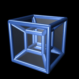
A esto es lo que se refiere la pelicula con los numeros binarios
La mejor forma de visualizarlo y entender la realidad es mediante la proyeccion de 4 a 2 dimensiones , un grafico ejemplo de la proyeccion natural a 2 dimensiones es la sombra, recordemos que el hipercubo es una figura en constante movimiento por lo tanto tiene 4 dimensiones, en la medida que congelamos estos movimientos vamos a obtener diferentes proyecciones 2 D o sombras.
Click para ampliar
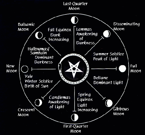
Como se pueden observar esta es la proyección octogonal del hypercubo, aqui el tiempo fluye sin problemas ya que el 9 y el 6 se encuentran distantes, con el correr del mismo a traves del eje en espiral se van a ir aproximando, las proyecciones del hipercubo pasan por muy diversas formas geometricas hasta finalizar su recorrido en el rombo dodecahedro, el Codigo Da Vinci de la granada, y el panal de los Masones, ya que estos estan construidos con redes de rombos dodecahedros. Digamos que esta sería la era dorada, el codigo de las manzanas doradas y el escarabajo dorado de Jung, la forma que tomaría despues de la explosion en el centro de la galaxia que invierte los cubos y provee la energia cinetica para un nuevo ciclo. Recordemos tambien que la forma de templo de Solomon era octogonal, lo mismo muchas iglesias templarias que seguian este codigo, y la estrella de 8 puntas que hemos revisado ya en las tablas sumerias, pasando por todos los codigos Masonicos hasta el osito gominola que baila sobre la misma representando a la constelación de la osa menor.
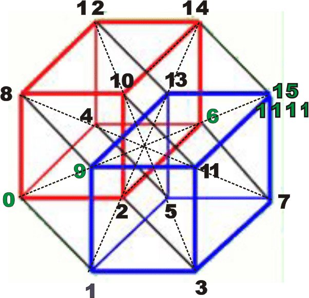
Entonces aqui tenemos las coordenadas cartesianas y binarias del rombo dodecahedro del hipercubo que es la forma que nos preocupa, sacado de Wikipedia, como veran no son mis coordenadas si no las de la propia figura, pueden comprobar que el 1001 y el 0110 son el 9 y el 6 juntandose en el medio y demas numeros referidos, caso 9-11 por ejemplo. Las calculadoras binarias estan disponibles a sola busqueda.
Notar que los angulos del medio estan levemente corridos para ubicar las dos coordenadas en el centro.
Video de profesor de Matematica dibujando el hipercubo octogonal con sus respectivas coordenadas cartesianas binarias, 4 ejes, x, y, z, y w como movimiento generando el tiempo, por lo tanto cada punto esta compuesto por 4 coordenadas, y tenemo 16 puntos en el sistema, cada cubo refleja 8 puntos, recordemos nuestro cubo de dominio 6 gira en sentido antihorario, y el de dominio 9 que viene hacia nosotros como Venus gira en sentido horario, el codigo del boton.
---------- Mensaje añadido a las 03:39 ---------- El original se escribió a las 03:01 ----------
Gabi creo que esto tambien responde tu pregunta, ademas de la granada recordemos los codigos de su construcción en base al rombo, el hexagono, el triangulo equilatero, en fin todos codigos que vamos a encontrar revisando todo tipo de simbolismo, hasta en la sopa y en el chocolate toblerone - con miel de abejas !
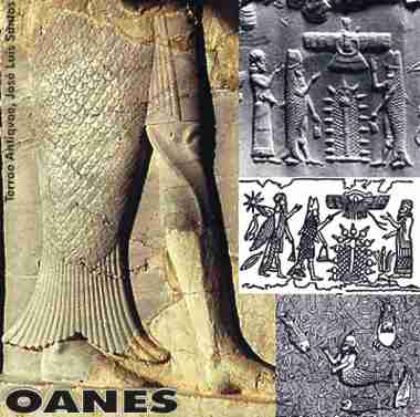
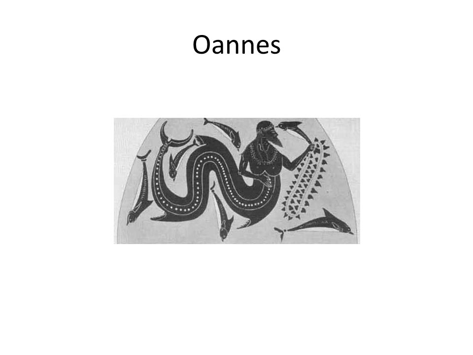
Finalmente si pudimos entender el concepto del hipercubo como la forma natural de la galaxia en constante movimiento. Entenderemos que con solo superponer el mapa estelar tendremos las coordenadas naturales de las estrellas incluido nuestro sistema solar. Facilmente podremos notar que 9-11 son las coordenadas del centro de la galaxia a nuestro sistema solar. Además de los codigos esotericos referentes al solsticio de verano como año Mason, codificado en el sol de junio dentro del Gran arco de la Fraternidad que es claramente un hipercubo, los bonfires de San Juan el Bautista que es el Oannes Sumerio representando la Vesica Piscis la cual circunda el rombo, etc, es sabido que nuestro sistema solar se encuentra debajo de Orion, por lo tanto no caben dudas de que nuestras coordenadas sean 11 y las del centro de la Galaxia 9. .
Centro de la galaxia 9 - La nebulosa del ojo del gato y sus siete vidas, el heptagrama en celeste que parte de un sistema trinario. 11 entre los cuernos del toro y Geminis, Venus-Isis la Diosa, transitara el sol entre los cuernos del Tauro el 4 de Junio, indicando el comienzo de la nueva era de Acuario y su ultimo ciclo de las eras, en Diciembre cierra el ciclo del heptagrama vinculado a la singularidad del centro de la Galaxia como la Diosa, la mujer, la luna y Urano que casualemente tiene una inclinacion de 60 grados de su eje, recordemos el espejo de Urania- femenino el septimo planeta.
El Voyager que esta fuera de la Galaxia confirmo que un componente magnetico de 60 grados golpea el sistema solar el cual toma una forma de bala al moverse sobre el eje de la precesión de los equinoccios.
Como se puede apreciar el componente magnetico son las cuerdas que atan los dos cubos, estando a 60 grados en el rombo dodecahedro y a 45 en el octogono, seguramente sean 59,9 ypico de grados aproximadamente y el solsticio de invierno en el norte, o sea el 21 de diciembre sea la fecha en donde se forma el perfecto rombo dodecahedro con la respectiva explosión en el centro de la galaxia que daria nacimiento al cristo solar 3 dias despues resucitando el 24 coincidiendo con la Navidad. La explosión se daría a 33 grados de las bases de la piramide los puntos alfa y omega, Acuario y Libra, de allí que cristo muera a los 33.
The Jordan River, in the state of Utah, United States, is a river about 51 miles (82 km) long. Regulated by pumps at its headwaters at Utah Lake, it flows northward through the Salt Lake Valley and empties into the Great Salt Lake. Four of Utah's six largest cities border the river: Salt Lake City, West Valley City, West Jordan, and Sandy. More than a million people live in the Jordan Subbasin, part of the Jordan River watershed that lies within Salt Lake and Utah counties. During the Pleistocene, the area was part of Lake Bonneville.
Members of the Desert Archaic Culture were the earliest known inhabitants of the region; an archaeological site found along the river dates back 3,000 years. Mormon pioneers led by Brigham Young were the first European American settlers, arriving in July 1847 and establishing farms and settlements along the river and its tributaries. The growing population, needing water for drinking, irrigation, and industrial use in an arid climate, dug ditches and canals, built dams, and installed pumps to create a highly regulated river.
Although the Jordan was originally a cold-water fishery with 13 native species, including Bonneville cutthroat trout, it has become a warm-water fishery where the common carp is most abundant. It was heavily polluted for many years by raw sewage, agricultural runoff, and mining wastes. In the 1960s, sewage treatment removed many pollutants. In the 21st century, pollution is further limited by the Clean Water Act, and, in some cases, the Superfund program. Once the home of bighorn sheep and beaver, the contemporary river is frequented by raccoons, red foxes, and domestic pets. It is an important avian resource, as are the Great Salt Lake and Utah Lake, visited by more than 200 bird species.
The Jordan River is Utah Lake's only outflow. It originates at the northern end of the lake between the cities of Lehi and Saratoga Springs. It then meanders north through the north end of Utah Valley for approximately 8 miles (13 km) until it passes through a gorge in the Traverse Mountains, known as the Jordan Narrows. The Utah National Guard base at Camp Williams lies on the western side of the river through much of the Jordan Narrows.[7][8] The Turner Dam, located 41.8 miles (67.3 km) from the river's mouth (or at river mile 41.8) and within the boundaries of the Jordan Narrows, is the first of two dams of the Jordan River. Turner Dam diverts the water to the right or easterly into the East Jordan Canal and to the left or westerly toward the Utah and Salt Lake Canal. Two pumping stations situated next to Turner Dam divert water to the west into the Provo Reservoir Canal, Utah Lake Distribution Canal, and Jacob-Welby Canal. The Provo Reservoir Canal runs north through Salt Lake County, Jacob-Welby runs south through Utah County. The Utah Lake Distribution Canal runs both north and south, eventually leading back into Utah Lake.[9] Outside the narrows, the river reaches the second dam, known as Joint Dam, which is 39.9 miles (64.2 km) from the river's mouth. Joint Dam diverts water to the east for the Jordan and Salt Lake City Canal and to the west for the South Jordan Canal.[10][11][12]
Map of the Salt Lake Valley
The river then flows through the middle of the Salt Lake Valley, initially moving through the city of Bluffdale and then forming the border between the cities of Riverton and Draper.[7] The river then enters the city of South Jordan where it merges with Midas Creek from the west. Upon leaving South Jordan, the river forms the border between the cities of West Jordan on the west and Sandy and Midvale on the east. From the west, Bingham Creek enters West Jordan. Dry Creek, an eastern tributary, combines with the main river in Sandy. The river then forms the border between the cities of Taylorsville and West Valley City on the west and Murray and South Salt Lake on the east. The river flows underneath Interstate 215 in Murray. Little and Big Cottonwood Creeks enter from the east in Murray, 21.7 miles (34.9 km) and 20.6 miles (33.2 km) from the mouth respectively. Mill Creek enters on the east in South Salt Lake, 17.3 miles (27.8 km) from the mouth. The river runs through the middle of Salt Lake City, where the river travels underneath Interstate 80 a mile west of downtown Salt Lake City and again underneath Interstate 215 in the northern portion of Salt Lake City. Interstate 15 parallels the river's eastern flank throughout Salt Lake County. At 16 miles (26 km) from the mouth, the river enters the Surplus Canal channel. The Jordan River physically diverts from the Surplus Canal through four gates and heads north with the Surplus Canal heading northwest. Parley's, Emigration, and Red Butte Creeks converge from the east through an underground pipe, 14.2 miles (22.9 km) from the mouth.[7] City Creek also enters via an underground pipe, 11.5 miles (18.5 km) from the river's mouth. The length of the river and the elevation of its mouth varies year to year depending on the fluctuations of the Great Salt Lake caused by weather conditions. The lake has an average elevation of 4,200 feet (1,300 m) which can deviate by 10 feet (3.0 m).[3] The Jordan River then continues for 9 to 12 miles (14 to 19 km) with Salt Lake County on the west and North Salt Lake and Davis County on the east until it empties into the Great Salt Lake.[7][8][11]
The United States Geological Survey maintains a stream gauge in Salt Lake City that shows annual runoff from the period 1980–2003 is just over 150,000 acre-feet (190,000,000 m3) per year or 100 percent of the total 800,000 acre-feet (990,000,000 m3) of water entering the Jordan River from all sources. The Surplus Canal carries almost 60 percent of the water into the Great Salt Lake, with various irrigation canals responsible for the rest. The amount of water entering the Jordan River from Utah Lake is just over 400,000 acre-feet (490,000,000 m3) per year. Inflow from the 11 largest streams feeding the Jordan River, sewage treatment plants, and groundwater each account for approximately 15 percent of water entering the river.[13]
Looking east through nave on 23 June 1976, two days after the summer solstice Mary Magdalene's relics in the crypt
In 1976, Hugues Delautre, one of the Franciscan fathers charged with stewardship of the Vézelay sanctuary, discovered that beyond the customary east-west orientation of the structure, the architecture of La Madeleine incorporates the relative positions of the Earth and the Sun into its design. Every June, just before the feast day of Saint John the Baptist, the astronomical dimensions of the church are revealed as the sun reaches its highest point of the year, at local noon on the summer solstice, when the sunlight coming through the southern clerestory windows casts a series of illuminated spots precisely along the longitudinal center of the nave floor.[13][14][15][16][17]
La primera expedición en llegar al polo sur geográfico fue liderada por el explorador noruego Roald Amundsen. Él, junto a otros cuatro noruegos que integraron la expedición (Olav Bjaaland, Helmer Hanssen, Sverre Hassel y Oscar Wisting), llegaron al polo sur el 14 de diciembre de 1911 y plantaron la bandera noruega. Amundsen denominó Haakon VII's Vidde al total de la meseta polar que rodea el polo sur y la reclamó para el rey Haakon VII de Noruega. Sin embargo, el Gobierno noruego no aceptó la reclamación del polo sur debido a que contradecía sus posiciones en la disputa con la Unión Soviética en el ártico, al haber rechazado la teoría de los sectores polares.
El empresario ballenero Lars Christensen financió 9 expediciones a la Antártida realizadas con los barcos Odd, Norvegia y Torshavn con el objetivo de explorar en busca de cetáceos. El Odd al mando de Anton S. Anderssen y de Eyvind Tofte expedicionó en 1927 a las Shetland del Sur y al mar de Bellingshausen. El Norvegia realizó 4 expediciones: en 1927-1928 al mando de Harald Horntvedt a las islas Georgias del Sur y Bouvet; en 1928-1929 al mando de Nils Larsen a las islas Bouvet, Shetland del Sur y Pedro I; en 1929-1930 al mando de Hjalmar Riiser-Larsen y de Nils Larsen a la isla Bouvet y la Tierra de Enderby en donde el 22 de diciembre de 1929 plantaron la bandera noruega, y luego descubrieron y mapearon la costa del Príncipe Olaf y la costa de la Princesa Marta; y en 1930-1931 al mando de Gunnar Isachsen y de Hjalmar Riiser-Larsen a la costa de la Princesa Ragnhild.[4] El Torshavn realizó 4 expediciones entre 1931-1937. En esas expediciones el 1 de diciembre de 1927 Noruega reclamó la subantártica isla Bouvet y el 2 de febrero de 1929 la isla Pedro I. El área costera desde los 37° Este hasta los 49°30′ de longitud Este descubierta en 1930 por Hjalmar Riiser-Larsen como parte de los esfuerzos por cartografiar la Antártida fue denominada Dronning Maud Land en homenaje a la reina Maud (1869–1938), esposa del rey Haakon VII de Noruega.
Hjalmar Riiser-Larsen, Finn Lützow-Holm y Viggo Widerøe realizaron fotografías aéreas y mapearon la Tierra de la Reina Maud entre 1929 y 1937. Estas expediciones exploraron completamente la costa de la Tierra de la Reina Maud entre los 16°30′ O y los 45° E, incluyendo gran parte del interior. Durante la expedición de 1936-1937 Viggo Widerøe voló sobre la zona costera llamada costa del Príncipe Harald.
Reclamación de Noruega
El 15 de abril de 1929 el Gobierno noruego expresó mediante una nota a los Estados Unidos que sobre la base de los descubrimientos realizados por Amundsen en el polo sur, tenía:[5]
base válida para una reivindicación de prioridad para adquirir esos territorios siempre que las exigencias del derecho internacional en cuanto a la ocupación efectiva de un nuevo territorio se hayan cumplido.
Luego de conversaciones en 1934 Noruega obtuvo tácitamente el consentimiento británico a reclamar los territorios entre las Dependencias de las Islas Malvinas y el Territorio Antártico Australiano, pero no lo hizo efectivo hasta que en diciembre de 1938 el Gobierno noruego tomó conocimiento de la partida en secreto de la Expedición Antártica Alemana dirigida por Alfred Ritscher hacia la Tierra de la Reina Maud con propósitos de anexión del área. Esta situación hizo que Noruega hiciera efectiva su declaración de soberanía sobre la Tierra de la Reina Maud mediante un decreto real del 14 de enero de 1939 (aprobado unánimemente por el parlamento el 3 de marzo de 1939):[6]
Kongen samtykkjer og skriv under eit framlagt utkast til kongeleg kunngjering om at den parten av fastlandsstranda i Antarktis som tøyer seg ifrå grensa for Falkland Islands Dependencies i vest (grensa for Coats Land) til grensa for Australian Antarctic Dependency i aust (45° austleg lengd) med det landet som ligg innafor denne stranda og det havet som ligg innåt, blir dregen inn under norsk statsvelde Traducción: El Rey aprueba y firma un borrador del Real Orden que proclama que la parte de la costa continental de la Antártida que se extiende desde los límites de las Dependencias de las islas Malvinas en el oeste (el límite de la Tierra de Coats) a los límites del Territorio Antártico Australiano en el este (45° de longitud este), con la tierra situada en la costa y el mar circundante, se pondrá bajo la soberanía de Noruega.
Los derechos aducidos por Noruega para reclamar el área estaban justificados por la exploración geográfica llevada a cabo por ciudadanos noruegos en ella, así como por el interés noruego sobre la pesca de cetáceos en vista de prevenir que otras naciones pudieran tomar allí medidas para impedirla. El Gobierno noruego tuvo cuidado de dejar en claro que su reclamación no constituía un sector polar, ya que desde principios del siglo XX el rechazo de la teoría de los sectores polares era una de sus principales políticas exteriores, por lo que el decreto real no definió el límite sur de la reclamación ni la extensión del área marítima. El decreto dio al ministro de Justicia autoridad para establecer regulaciones en el área.
Noruega comunicó el decreto real a países con los que tenía relaciones diplomáticas, de los cuales recibió objeciones de Estados Unidos, Chile, la Unión Soviética y Alemania. El Reino Unido respondió el 1 de septiembre de 1939 aceptando la reclamación y sugiriendo que el límite oeste fuera fijado en los 20° Oeste, ya que la definición en el límite de la Tierra de Coats era vaga, lo cual fue aceptado por Noruega.[7] En una nota del ministro de Asuntos Exteriores de Alemania, Joachim von Ribbentrop, de 23 de enero de 1939, el Gobierno alemán disputó el reclamo noruego. Ritscher llegó a la costa de la Princesa Martha el 19 de enero de 1939 y los expedicionarios alemanes fotografiaron un área de aproximadamente 350 000 km² que fue denominada Neuschwabenland (Nueva Suabia), hasta su partida de regreso el 6 de febrero de 1939. Fuentes noruegas afirman que Alemania habría anunciado la formación de un Sector Antártico Alemán en agosto de 1939, entre los 4°59′ E y los 16°30′ E y hasta los 75° S.[8]
En respuesta a la proclamación, el 27 de enero de 1939 el Comisariado Popular de Asuntos Exteriores de la Unión Soviética rechazó categóricamente todos los actos unilaterales en relación con la soberanía sobre los territorios antárticos y subrayó sus derechos históricos al descubrimiento de la Antártida en virtud de las expediciones de Bellingshausen y Lázarev.[9] La reclamación noruega solo fue reconocida explícitamente por cuatro países: Francia, Australia, Nueva Zelanda y el Reino Unido, todos los cuales reconocen mutuamente sus reclamaciones antárticas.[10][11]
Desde la entrada en vigor el 23 de junio de 1961 del Tratado Antártico -del que Noruega es miembro signatario original- ninguna reclamación territorial preexistente puede ampliarse, por lo que el área de la reclamación permanece indefinida. Sin embargo, el Gobierno noruego sostiene que el propósito de su reclamación fue el de establecer la posesión de la tierra que hasta entonces había estado sin gobierno y que nadie más que los noruegos habían estudiado y mapeado, por lo que las autoridades noruegas no se oponen a la interpretación de que el reclamo noruego se extiende hasta el polo sur.[12][13]
El 21 de junio de 1957 el parlamento noruego definió el estatus de la Tierra de la Reina Maud como dependencia, enmendando la ley del 27 de febrero de 1930 que dio ese estatus a las islas Bouvet y Pedro I. Un área con el estado de dependencia es parte del territorio noruego, pero no forma parte del Reino de Noruega.
Entre 1949 y 1952 se llevó a cabo la primera expedición internacional noruego-sueco-británica, comúnmente llamada expedición Maudheim, liderada por el noruego John Giæver. La expedición realizó una serie de investigaciones científicas basadas en la estación de investigación Maudheim, construida en febrero de 1949 en la barrera de hielo Jelbart en la costa de la Princesa Marta. El 15 de enero de 1952 la base Maudheim fue abandonada.[15]
Extendiendo los sectores limitados por meridianos hasta el Polo Sur, según el Comité Consultivo sobre Nomenclatura Antártica de Estados Unidos la Tierra de la Reina Maud comprende las áreas expresadas en la siguiente tabla (de oeste a este):
Los límites intermedios pasaron a ser de oeste a este: Lengua de hielo Troll/Trolltunga, cabo Sedov/Sedovodden, fondo de la bahía Vestvika, y glaciar Shirase/Shirasebreen.
En 1948 Noruega y el Reino Unido acordaron que el nombre Tierra de la Reina Maud se redujera al sector noruego y no se extendiera al Territorio Antártico Británico, mientras que el nombre británico Tierra de Coats fue omitido en el sector noruego y reducida hasta el límite entre ambas reclamaciones. La costa Bruce, que era la parte de la Tierra de Coats que se hallaba al oriente de los 20° Este, desapareció de la cartografía británica.[17]


![That's one small step..." —Neil Armstrong [1024 x 1333] : r/QuotesPorn](https://i.imgur.com/lfLGX.jpg)