|
|
GIZE, STONEHENGE, CHICHEN ITZA, ETC,ETC: The Keys of Atlantis-Vescica Piscis y el paralelo 30/Gran Piramide
Scegli un’altra bacheca |
|
Rispondi |
Messaggio 1 di 62 di questo argomento |
|

The Keys of Atlantis
A Study of Ancient Unified Numerical and Metrological Systems
by Peter Wakefield Sault
Copyright © Peter Wakefield Sault 1973-2012
All rights reserved worldwide
The Keys of Atlantis
Chapter 3.
Mountains of The Moon
The Stone-Cored Pyramids of Egypt
|
PROLEGOMENON
This little treatise is a mathematical, metrological, geographical and astronomical analysis of certain Egyptian pyramids. English translations of their ancient traditional names, less the names of the kings to whom rightly or wrongly a much later Egyptian priesthood attributed their building, are used here throughout except when quoting other authors. This is problematic since the original Great Pyramid is nowadays generally referred to as Khafre, Khephren or the Second Giza Pyramid. The original name of the pyramid now widely though erroneously known as the ‘Great Pyramid’ is Pyramid of The Horizon, or simply Horizon Pyramid. If, that is to say, ‘Horizon’ is the correct interpretation of the hieroglyph Akhet, about which some apparently justifiable doubt remains. In order to minimise the reader's possible confusion, the original and true Great Pyramid (i.e. ‘Khephren’) will here be referred to as the Grand Pyramid.
|
Sections
Illustrations
Animations
Tables
References
3-1. The Giza Complex

Figure 3-1. The Pyramids of Giza (1)

Figure 3-2. Map of The Giza Pyramid Complex
3-2. The Horizon Pyramid
The Pyramid of The Horizon, known variously although erroneously as the Pyramid of Khufu, Pyramid of Kheops, Great Pyramid or First Giza Pyramid, stands on the Giza Plateau in Egypt at 29° 58' 45" N × 31° 08' 03" E. These and all other geographical coordinates given in this chapter have been obtained since 2006 with the aid of Google Earth and supercede all earlier figures from other sources.
Peter Tompkins summarizes the origin of the Horizon Pyramid thus[1]
“Though all agree that the Great [Horizon] Pyramid is at least four thousand years old, none can say for certain just when it was built, by whom, or why.”
The first thing to note about this observation is that Tompkins refrains from attempting to assign a maximum age to the Horizon Pyramid.
Tompkins' book ‘Secrets of The Great [Horizon] Pyramid’ (1971) is without doubt the most comprehensive compendium of myths, legends and knowledge about the Horizon Pyramid ever published and was, as noted on his website*, “not yet faulted in its original content”. Until now, that is to say, firstly in respect of his misapplication of the name ‘Great’ to the Horizon Pyramid and secondly in his treatment of Isaac Newton's fictive ‘Memphis Cubit’ as if it were a genuine unit of measure when it was never more than a figment of Newton's fevered imagination. These matters will be discussed in detail in the final section of this chapter, ‘The Egyptological Fraud’.
Tompkins goes on to say[2]
“It would be satisfactory to be able to describe the method by which the Great [Horizon] Pyramid was put together, by whom, and when.
“But the builders, whoever they may have been, left no description of their method. No one has even found a later Egyptian report of how the first pyramids were built.”
The earliest extant reference to the Horizon Pyramid comes from Herodotus, who says[7]
“To build the pyramid itself took twenty years; it is square at the base, its height (800 feet) equal to the length of each side; it is of polished stone blocks beautifully fitted, none of the blocks being less than thirty feet long.”
It would be another 2,000 years before the Horizon Pyramid was accurately surveyed and the relationship between its height and the length of each side thereby properly observed. With the missing part of the statement inserted:– The quadrant whose radius is the height is equal to the length of each side.

Figure 3-3. Theoretical Proportions of the Horizon Pyramid
Some of the earlier surveys contained errors and gave rise to some preposterous theories, none of which will be discussed here, about which Prof. W.M.F.Petrie says[8]
“It is useless to state the real truth of the matter, as it has no effect on those who are subject to this type of hallucination. They can but be left with the flat earth believers and other such people to whom a theory is dearer than a fact.”
http://www.odeion.org/atlantis/chapter-3.html |
|
|
|
Rispondi |
Messaggio 3 di 62 di questo argomento |
|
That is exactly equal to 7,623 12-cubit cubes; cubes, that is, of surface area equal to that of the theoretical metrological cavity. Now, these 7,623 cubes can be arranged as a stack of 7 equal square tiers of width 33. With the width of the tiers equal to the width of the base of the pyramid, the height of the resulting rectangular block is exactly 1/3rd of the height of the pyramid. Altogether, the figure clearly embodies in whole numbers the arithmetical method for calculating the volume of any pyramid; one third of the height times the area of the base.
Hence it may be concluded that the Horizon Pyramid was laid out and constructed using the pyk belady as its modulus. However, because nothing is known about the history of this unit of measure beyond its use in the construction of the Horizon Pyramid and its general use in Egypt at the time of Jomard's visit, its age and origin cannot be established and, therefore, no firm conclusion can be drawn about the age of the Horizon Pyramid from its use. Jomard's observation is seemingly the only connection to any memory of its existence, since all other mentions of this unit themselves refer back to him as their source. Nonetheless it is clear that the linear modulus of the Horizon Pyramid possesses a unique name and is no mere hypothesis. Not only that but the Horizon Pyramid linear modulus can confidently be labelled the Egyptian cubit, for that indeed is what it is.

Figure 3-8. The Egyptian Stade
Taking the disk of the Earth as a circle and the value of pi as 22/7, in Egyptian stades of 400 cubits the circumference so obtained is exactly 171,072 Egyptian stades and the radius 27,216. A Greek stade on the same circle would be exactly equal to 99/125 Egyptian stade (terrestrial circumference = 216,000 Greek stades).
The Horizon Pyramid width, at 99/100 Egyptian stades, is equally interesting since the terrestrial circumference comes out at 172,800 or 100 times the cube of 12. Moreover, again on the same circle, it is exactly equal to 1¼ Greek stades, the Greek metric standards having been supplied to Solon by the Temple of Neith at Sais around 600 BC, suggesting an unbroken tradition stretching from the building of the Giza complex to that of the Parthenon of Athens. The Greek system of linear measures was derived from the Egyptian and both include a digit (finger) as the smallest unit, a foot of 16 digits, a cubit of 24 digits and a stade of 600 feet.

* Peter Tompkins' website was removed from the World-Wide Web in February 2008, a year after his death in January 2007. This author has a copy saved in his archives.
3-3. The Grand Pyramid
The mean width of the base of the Grand Pyramid is almost exactly 370 Horizon cubits (pyk belady), the variance being roughly 1 part in 6,000 or 0.016%, and here the rounded figure will be assumed to be the intended width. This pyramid was apparently intended to conform to the proportions of a Pythagorean {3-4-5} triangle, giving a theoretical height of 246⅔ cubits or 370 feet.

Figure 3-9. Theoretical Cross-Section of The Grand Pyramid
The theoretical volume of the Grand Pyramid is exactly 37,989,750 cubic Horizon feet.
37,989,750 = 2 × 3 × 53 × 373 = 6 × 1853
The length of each edge of the 6 cubes so defined is equal to half the height of, and to one third the width of, the pyramid.
3-4. The Divine Pyramid
Petrie's mean for the width of the Divine Pyramid is 4,153.6 English inches, or roughly 181.34 Horizon cubits with a probable intended figure of 181⅓ cubits, or 272 Horizon feet exactly, differing from the mean by –0.004%. For the angle of the apothem Petrie's “best conclusion” is 51°0' ± 10'. This results in a height somewhere between 2549 and 2580 English inches, or roughly 167 and 169 Horizon feet. Taking the mean gives a height of 168 feet and this will be found to share a common factor of 8 with the theoretical width. Hence the proportions are 21 rise on 17 base, revealing a clearly intended allusion in the division of the width by the height to Φ (Phi), the Golden Mean or Divine Proportion, differing from it by a mere +0.06%. In fact the ratio of height into width, 21:34, displayed by the Divine Pyramid is the 8th term of the Fibonacci Sequence, which converges to Phi.[18]


Figure 3-10. Theoretical Cross-Section of The Divine Pyramid
The theoretical volume of the Divine Pyramid is exactly 4,143,104 cubic Horizon feet.
4,143,104 = 7 × 342 × 83
* * *

Figure 3-11. The Ratio between The Heights of Horizon And Divine Pyramids
The ratio between the heights of Horizon and Divine pyramids is the same as that between the length and breadth respectively of the platform of the Parthenon of Athens - 4:9. This ratio belongs to the Lambda, itself the root and source of the dodekaphonic musical scale, as described in Chapter 1, suggesting that the Giza complex comprises an integrated design and that its overall planning was completed before a single stone was quarried for a single pyramid.

Figure 3-12. The Pyramids of Giza (2)
3-5. The Southern Shining Pyramid

Figure 3-13. The Southern Shining Pyramid
The reader can forget the Egyptological dogma that seeks to explain the compound slope of the Southern Shining Pyramid as a decision by the builders to switch slopes in mid-project, the rationalization of this usually being that they discovered that the internal stresses of the structure prevented completion of a pyramid with the continued slope of the lower section. How exactly they discovered this is never made clear and no evidence supporting the stress-factor hypothesis is ever presented. It is of course a flight of fancy, for from the outset the Southern Shining Pyramid was designed to be a flattened obelisk, as the following analysis of its geometry will make very clear.
| Quantity | Measure
|
Width at ground level
|
188 metres (617 feet)
|
Height overall
|
105 metres (345 feet)
|
Upper dihedral angle
|
43° 22'
|
Lower dihedral angle
|
54° 27' 44" Table 3-2. Reported Measures of The Southern Shining Pyramid [
16]
As with the Horizon Pyramid, the linear modulus of the Southern Shining Pyramid is a 9th part of the width, 207.09 English inches, of its principal cavity, giving a Southern Shining cubit of 23.01 English inches. With this unit the height of the pyramid emerges as 180 cubits and the width of its base as 324 cubits. The rest follows accordingly as shown in Figure 3-14. A small adjustment to the reported dihedral angle of the upper faces is needed to bring the whole scheme into perfection.

Figure 3-14. Theoretical Slopes of The Southern Shining Pyramid
|
|
|
|
Rispondi |
Messaggio 4 di 62 di questo argomento |
|
The theoretical volume of the Southern Shining Pyramid is exactly 7,286,976 cubic Southern Shining cubits.
7,286,976 = 123 × 4217
The outer form contains an implied inner, or hidden, pyramid.

Figure 3-15. Theoretical Slope of The Hidden Pyramid
The theoretical volume of the Hidden Pyramid is exactly 6,298,560 cubic Southern Shining cubits.
6,298,560 = 123 × 93 × 5 = 5 × 1083
The length of each edge of the 5 cubes so defined is equal to three fifths (0.6) the height of, and to one third the width of, the Hidden Pyramid.
3-6. The Rising Sun Pyramid

Figure 3-16. The Rising Sun Pyramid
The Rising Sun Pyramid, also known as the Red Pyramid because of the colour of its exposed rocky core, is located in the Dahshur pyramid field at 29° 48' 30.9" N × 31° 12' 22" E. This is a large pyramid with a rock core and, like every pyramid and mastaba, has been stripped of its limestone casing by stone robbers, leading directly to the complete and utter collapses of those many pyramids which had been built with mud brick cores. However, with the cores exposed aerial photography and now satellite imaging reveal that those of both the Horizon Pyramid and the Rising Sun Pyramid are stellated, something that would have remained undetectable and completely unknown had they retained their unstellated casings. This means only that both pyramids are unquestionably products of the same guild of architects, assuming that no single architect working in isolation could have raised all the stone-cored pyramids given both the magnitude of each project individually and the number of other pyramids with similarly stellated stone cores.
| Quantity | Measure
|
Width
|
220 metres (722 feet)
|
Height
|
105 metres (345 feet)
|
Dihedral angle
|
43° 22' Table 3-3. Reported Measures of The Rising Sun Pyramid [
17]
The form of the Rising Sun Pyramid is defined by a circle and an equilateral triangle:-
- The perimeter of the equilateral triangle is equal to the circumference of the circle (π = 22/7).
- The height of the pyramid is equal to the radius of the circle.
- The width of the pyramid is equal to one side of the equilateral triangle.

Figure 3-17. Theoretical Geometry of The Rising Sun Pyramid
|
|
|
|
Rispondi |
Messaggio 5 di 62 di questo argomento |
|
It should be noted that the recovery here of the ancient Egyptian stade has been made possible only very recently by the emergences of the Global Positioning System and Google Earth (see Appendix C). In other words, with data from artificial satellites and radio telemetry. The question of how the builders could position the Horizon Pyramid so very precisely without such aids belongs with that other great mystery – how the Horizon Pyramid was built.
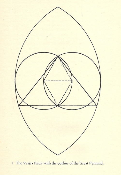
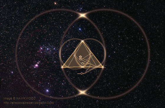
The significance of the 30th Parallel in the scheme of things is that it can be geometrically constructed in cross-section, with compasses and straightedge, via a vesica piscis. The three-dimensional analog of the vesica is formed by the overlapping of two equal spheres such that the centre of one lies on the surface of the other, with the 30th Parallel occurring along the intersection of the surfaces.

Figure 3-19. Vesica Piscis And 30th Parallel
From here on the latitudes of the apex of the Horizon Pyramid, of the radius of exactly 3⅔ Lunar radii and of the most northerly overhead Moon will be treated as identities of the 30th Parallel. Furthermore, Moon and Earth will be treated as reference spheres whose radii are in the ratio 3:11. And π will be evaluated at 22/7, for by doing all of these things a series of remarkable coincidences will be encountered.

Figure 3-20. Earth, Moon And Horizon Pyramid
|
|
|
|
Rispondi |
Messaggio 6 di 62 di questo argomento |
|
When the disk of the Moon is also enclosed in a square, the first such coincidence is the appearance of Pythagorean {3-4-5} triangles in the geometrical construction resulting from its juxtaposition with the disk of the Earth.

Figure 3-21. Earth, Moon And {3-4-5} Triangles
Extending the construction to form a cross-section of the Grand Pyramid, the lengths of the component lines must be multiplied up, in this case by 12 (the sum of 3, 4 and 5), in order to continue expressing them all as whole numbers. This gives a unit exactly equal to 60 English miles, 60 being the product of 3, 4 and 5. Put another way, if the modulus of the diagram shown in Figure 3-22, equal to 1/132nd of the diameter of the Terrestrial reference sphere, the Grand span, is subdivided by the product of 3, 4 and 5 then the result is a unit of length which is exactly equal to a modern English or U.S. mile.

Figure 3-22. Earth, Moon And Grand Pyramid
In terms of the Grand span derived in Figure 3-22, the combined diameters of the Terrestrial and Lunar reference spheres is 168. That is also the number of hours in each and every week. Just as the Grand span is exactly divisible into 60 English miles, so the hour is divided into 60 minutes and the number of minutes in every seven-day period is exactly 10,080. Seven days is very roughly the period of a single Lunar quarter.

Figure 3-23. The Seven Days of The World
The radius of the large circle whose circumference is equal to the perimeter of the square around the Earth, taking π (pi) to be 22/7, is 5,040 miles. 5,040 is the product of all the numbers from 1 to 7, written 7! and is known as the factorial of seven.
5,040 = 1 × 2 × 3 × 4 × 5 × 6 × 7 = 7!
The modulus of the diagram shown in Figure 3-21 is 720 miles. 720 is the factorial of six.
720 = 1 × 2 × 3 × 4 × 5 × 6 = 6!
The circumference of the large circle, again taking π = 22/7, is exactly 528 Grand spans, or 31,680 miles, and this is of course equal in length to the perimeter of the square around the Earth, the base of the virtual cosmic Horizon Pyramid whose height is equal to the combined radii of Earth and Moon, or 5,040 miles.

Figure 3-24. Abhisambodhi Vairocana Mandala (Tibet, 14th Century)
|
|
|
|
Rispondi |
Messaggio 7 di 62 di questo argomento |
|
The story of the Grand span does not end there but provides yet another identity of the 30th Parallel. At latitude 29°45'30" N, some 16½ miles south of the Horizon Pyramid, the circumference of the parallel is exactly 360 Grand spans. This means that the Grand span is the length of a degree and the mile the length of a minute of arc along that parallel.

Figure 3-25. The 30th Parallel
3-9. The Western Cubit And Foot
Before the introduction of the Napoleonic system, in one form or another Long Measure was in widespread use throughout Western Europe . Evidence for this lies in the Spanish, or classical, guitar which will be found always to have a 24-inch action, as shown in Figure 3-26.

Figure 3-26. The Dimensions of A Classical Guitar
Twenty four inches or digits comprise a common cubit, the particular length here (609.6mm) being the Western European standard, as distinct from Greek, Egyptian or other standardized cubits. The English system includes a great cubit, the yard, equal to 1½ common cubits, from which the inch is derived*. The English statutory foot, however, appears to be defective or aberrant since it breaks the general rule that makes the common cubit the harmonic mean of it (the foot) and the great cubit. The foot is that unit in the cubit sequence which cannot be divided in three equal parts each a whole number of digits and which thereby naturally terminates the sequence. Hence a proper Western foot would have to be 16 inches (406.4mm) long, just as Greek and Egyptian feet each comprise sixteen of their respective digits.
There are exactly 3,960 such Western feet in a mile, thus the Western foot divides the mile in exactly the same number as the mile divides that radius of the Earth, at 29°26'45" N, which is in an exact ratio of 11:3 with the radius of the Moon.

Figure 3-27. A 24-Inch Steel Rule (Rabone Chesterman, England, 1970)
* The Statutum de Admensuratione Terrae (1305) states [13]:-
3-10. The Great Circle Way

Figure 3-28. Pyramids Road (Map: Google)
Al-Ahram, Pyramids Road, is a broad thoroughfare that runs in a straight line WSW from the Nile, terminating in the desert about five hundred yards north of the Horizon Pyramid. It is very ancient, possibly even more so than the pyramids themselves. It seems as if the city of Cairo itself has sprung up around this very road.

Figure 3-29. The Great Circle Way Discovered in Cairo (Satellite imagery: Google Earth)
The azimuth of Pyramids Road at Cairo is 66.666°, making it a segment of a great circle whose northern vertex lies on the High Pass through the Himalayas in the vicinity of Kashmir at coordinates 37° 18' N × 71° 54' E. This same great circle is the shortest uninterrupted land route from the Atlantic coast of Africa, Liberia to be precise, to the Pacific coast of China. Curiously, the point at which it meets the Atlantic is also the eastern end of the shortest route across the Atlantic.

Figure 3-30. The Great Circle Way from Atlantic to Pacific (Satellite imagery: Google Earth)

Figure 3-31. The Middle East in 1450 BC Traversed by The Great Circle Way
3-11. The Egyptological Fraud
In 1654 James Usher, Archbishop of Armagh, announced that the Earth was ‘created’ in 4004 BC. This he did – without a trace of irony – on the basis of a patently absurd Judaic myth. A contemporary of Isaac Newton, John Lightfoot, Vice-chancellor of the University of Cambridge went so far as to narrow it down to 9 o'clock a.m. on the 23rd October of the same year[15]. Moreover, even this year, which must have seemed almost unimaginably ancient to Usher and Lightfoot, was obtained by downright fraud – the presentation of ages measured in months as if they were in solar years. The fraud was neither's but was instead that of the authors of the Judaic mythology, which may not even be a genuine mythology at all but one concocted for political purposes. For example, the age to which Noah is alleged to have lived was 950 solar years and these years are factored into the date of ‘Creation’ given above. It is quite obvious that the lifespan of Noah was not 950 solar years but the same number of months and using a nominal conversion rate of 13 months per solar year this translates to 73 solar years. Clearly Noah was an ordinary man, alleged extraordinary feats notwithstanding. In correcting this lifespan alone, the date of ‘Creation’ is brought forward by 877 years. However, Noah was not the only ancient Hebrew credited with an over-extended lifespan. If the age of Adam (930 months = 71½ years) and the period from Adam's death to the birth of Noah (216 months = 16½ years) are similarly corrected, then the date of ‘Creation’ must be brought forward by 1,935 years. Applying similar corrections to all the “generations of Adam”, the year of ‘Creation’ turns out to have been around 2000 BC at the earliest. If the dubious attribution of the Horizon Pyramid to King Khufu and the even more dubious dating of his reign to around 2600 BC are accepted then the pyramid must have been completed some six hundred years before ‘Creation’.
Nonetheless, despite the utter improbability of its claims and the complete lack of any supporting or corroborating evidence of a Hebrew or ‘Israelite’ presence there, Jean-François Champollion, the so-called ‘Father of Egyptology’, based his kinglist of Ancient Egypt upon the books of the Torah. As Peter Tompkins puts it:[19]
“By the time he was seventeen, Champollion had made his first table of the succession of Egyptian pharaohs, based on data culled from the Old Testament.”
Tompkins displays an interesting turn of phrase. When he states that Champollion “based” his kinglist on the so-called “Old Testament”, what he is actually saying (whether he knew it or not) is that Champollion fabricated a kinglist to conform to the Torah. This means that the entire history of the peoples of the Nile Valley as presented to the world by ‘Egyptologists’ cannot be trusted and is, therefore, worthless. Moreover it means that even if a King Khufu was indeed the commissioner of the Horizon Pyramid, as asserted to Herodotus by the Saite priesthood around 440 BC, the dating of his reign is based upon false evidence. All of the evidence that might have revealed some of the true history has been subject to systematic removal or destruction by subsequent generations of ‘Egyptologists’ with the singular purpose of continued funding from those with a vested interest in the perpetuation of fabricated histories, in particular that of the Torah. Academia is being selective when it chooses to believe what a priesthood had to say to Herodotus about the commissioner of the Horizon Pyramid and yet to disbelieve that same priesthood when, in around 600 BC, it informed Solon that an entire civilization had disappeared from the face of the Earth some 9,000 years before their time.
Champollion, like Newton before him, was a Freemason and likewise immersed in the masonic machinations of his time.
To be continued
Mountains of The Moon
References
| 1. |
|
Peter Tompkins, Secrets of The Great [Horizon] Pyramid, 1971, p.xiii |
| 2. |
|
ibid. p.217 |
| 3. |
|
ibid. pp.30-31 |
| 4. |
|
ibid. p.77 (footnote) |
| 5. |
|
ibid. p.47 |
| 6. |
|
Livio Catullo Stecchini, Notes On The Relation Of Ancient Measures To The Great [Horizon] Pyramid, included as an appendix to Secrets of The Great [Horizon] Pyramid, 1971, p.323 |
| 7. |
|
Herodotus, The Histories, circa 440 B.C. |
| 8. |
|
W.M.F.Petrie, Seventy Years in Archaeology |
| 9. |
|
W.M.F.Petrie, The Pyramids and Temples of Gizeh, 1883, p.88 |
| 10. |
|
ibid. p.27 |
| 11. |
|
ibid. p.28 |
| 12. |
|
ibid. p.13 |
| 13. |
|
A.E.Berriman, Historical Metrology, 1953, p.170 |
| 14. |
|
Derek Gjertsen, The Newton Handbook, 1986, p.6 |
| 15. |
|
ibid. p.7 |
| 16. |
|
Mark Lehner, The Complete Pyramids, 1997, p.102 |
| 17. |
|
ibid. p.104 |
| 18. |
|
H.E.Huntley, The Divine Proportion, 1970, p.47 |
| 19. |
|
Peter Tompkins, The Magic of Obelisks, 1981, p.160 |
The Keys of Atlantis
http://www.odeion.org/atlantis/chapter-3.html
“And be it remembered that the Iron Yard of our Lord the King containeth three feet and no more. And a foot ought to contain 12 inches, by the right measure of this yard measured; to wit the thirty-sixth part of this yard rightly measured maketh an inch neither more nor less.” |
|
|
|
Rispondi |
Messaggio 8 di 62 di questo argomento |
|
Al igual que vimos el pasado día con el arquitecto español, dan un repaso a los increibles conocimientos matemáticos que tenían los constructores originales de las pirámides…

24-05-12 La Vanguardia entrevista al arquitecto español Miquel Pérez-Sánchez: "La pirámide de Keops conmemora el diluvio universal"…Avanzadísimas matemáticas se esconden en las medidas de la pirámide!!
También nos explican porque los constructores de las pirámides eligieron una medida tan aparentemente irregular que era el "codo"… 0,5235 metros…
Y el porque utilizaron esa extraña medida es tan sencillo, cómo dividir el diámetro de una circunferencia de 1 metro, pi entre 6…3,1416 / 6 = 0,5236…
O también…
")
Y todo medido en METROS!!!
Y la altura?? Sencillo, basandonos en geometría…
")
Pero no nos olvidemos que la altura de la pirámide es de 147 metros…
y la distancia al Sol en el perihelio es poco más de 147 millones de kilómetros
Es decir, calcularon la base para que la altura fuera esa…y cómo sabían la distancia que había al sol en sistema métrico??
Pero que dicen los matemáticos sobre la probabilidad de que fuese todo una casualidad ?…de que no conociesen ni el metro ni Pi, ni Phi?…PRACTICAMENTE NULA!!!!
ESTO ES CIENCIA, y durante años hemos sido catalogados como pseudocientíficos…Manda narices!
")
Y otro tema que ya alguno se estará preguntando…cómo conocían el metro si está basado en una medición de la CIRCUNFERENCIA DE LA TIERRA????????
Concretamente…
METRO = la diezmillonésima parte de la distancia que separa el polo de la línea del ecuador terrestre
y esto fue definido oficialmente por primera vez en 1791..
je je…Cómo????
Que sabían que la TIERRA ERA REDONDA??? y no sólo eso, sino que conocían sus medidas????
Je je…me lo estoy pasando BOMBA!!!!
Conocimientos que han pasado desapercibidos para la GRAN MAYORÍA, salvo para la MASONERÍA…sociedades secretas…cuyos integrantes construían templos, catedrales, etc, y ya utilizaban también con anterioridad a 1793 la medida del metro……cuando en esas épocas la gran pirámide estaba todavía enterrada en la arena…de nuevo..jeje!
Y sentaos que con lo siguiente os podéis caer de espaldas!!!
Y aquí no acaba la cosa…
|
|
|
|
Rispondi |
Messaggio 9 di 62 di questo argomento |
|
PART 9 - IN SEARCH OF ATLANTIS
The story of Atlantis is generally credited to Plato, even though he ascribed the story to much earlier Egyptian sources. According to those sources, the ancient, advanced Atlanteans ruled over islands and continents from an island kingdom outside of the Pillars of Hercules, which is thought to be the Straights of Gibralter. In Greek mythology, Atlas was the first king of Atlantis. Atlas had seven daughters known as the Atlantides. Because their mother was named Hesperis, they were also known as the Hesperides.
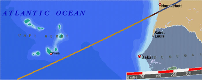
Machupicchu and the Great Pyramid are equally distant from the Cape Verde Islands. Easter Island and the Indus Valley are also equally distant from Cape Verde. When the Cape Verde Islands were rediscovered by European mariners in 1460 they were found to be uninhabited. However, islands in this location are found on earlier maps and described as inhabited in ancient times.
The Mecia de Viladestes map of 1413 shows islands in the location of Cape Verde labeled Gades. The information in this map is thought to have come from Roman sources dating back to the first century AD.
The discoveries of the world from their first originall unto the yeere of our Lord 1555, written by Antonio Galvao in 1563, lists the ancient names for the Cape Verde Islands as the Dorcades, Hesperides and the Gorgades. A 1587 map by Richard Hakluyt also labels the Cape Verde Islands as the Gorgades and the Hesperides.
According to Plato, there was a mountainous region north of the city of Atlantis. One possible location for Atlantis is in the Atlantic Ocean, just south of the Cape Verde Islands.
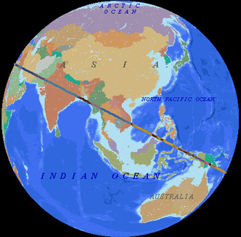
Arysio Nunes dos Santos proposed that Atlantis was originally located in the Bay of Bengal, just south of the mouth of the Ganges, and in the South China Sea. These areas were above sea level during the earth's last glaciation. The landmass that forms the shallow bottom of the South China Sea is the only known area on earth, large enough to meet Plato's description of the size of Atlantis, that sank at the end of the last ice age. Santos argues that scientific evidence, and references in ancient writings, folklore and myths, prove that the South China Sea and the Bay of Bengal were the original sites of Atlantis and Lemuria. Santos contends that a super eruption of Krakatoa in Atlantean times destroyed Atlantis and caused the end of the last ice age by covering the earth with volcanic ash which absorbed sunlight and melted the ice. The alignment of world wonders crosses over the Bay of Bengal, just south of the mouth of the Ganges, and goes right across the middle of the South China Sea. The halfway point betwen Mohenjo-Daro and Angkor is also located in the Bay of Bengal.
Another possible Atlantis location is halfway between the Great Pyramid and Easter Island, at 4° 19' north latitude, 41° 30' west longitude, under the Atlantic Ocean northeast of the mouth of the Amazon. On the diagram below, the marked locations are Giza, Angkor, Anatom Island, Easter Island, and 4° 19' north latitude, 41° 30' west longitude in the Atlantic Ocean. The distance from the Great Pyramid to Easter Island is approximately 40% of the circumference of the earth. The marked location in the Atlantic is halfway between the two, 20% each way. Machupicchu is halfway between Easter Island and the marked location in the Atlantic, 10% each way. The Distance from the Great Pyramid to Angkor Wat is approximately 20% of the circumference, and the Indus Valley is halfway between the two, 10% each way. The Distance from Easter Island to Angkor Wat is approximately 40% of the circumference, and Anatom Island is halfway between them, 20% each way. Although there are no islands in the Atlantic near 4° 19' north latitude, 41° 30' west longitude, it is interesting to note that the famous Piri Reis map shows a large island in this location, and the geology of recent core samples, taken from the ocean floor in this area, is of continental rather than oceanic type rock.
|
|
|
|
Rispondi |
Messaggio 10 di 62 di questo argomento |
|
PART 11 - THE NEW ATLANTIS
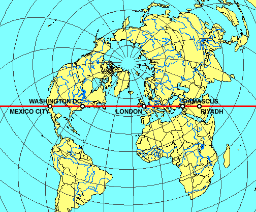
The old urban centers on the Eastern Seaboard of the U.S are in nearly perfect alignment. The image below is a cropped 3D projection centered on New York City.
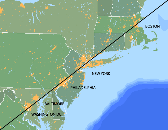
Map image © VectorGlobe
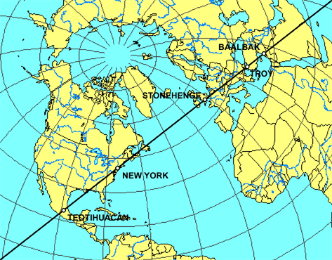
This great circle line crosses through the middle of Washington DC and the middle of Boston, and it crosses right over the middle of New York City. It also crosses over Philadelphia and the Baltimore waterfront. The azimuth of this line as it crosses over NYC is 52°, which is also the angle of the sides of the Great Pyramid. The image below is an equal azimuthal projection, also centered on New York City, with this same alignment extended in both directions.
Map image - Roger Hedin
The alignment crosses between Teotihuacan and Cholula in Mexico and just as this alignment crosses into Mexico from the gulf it crosses over the ancient city of El Tajin and the pyramid of niches. The alignment also crosses over Baalbek, Lebanon and just north of the ancient city of Troy. The alignment also crosses over Stonehenge. The azimuth of the alignment as it crosses over Stonehenge is 72° west of due north and 72° east of due south, which is not the same as the primary alignment of Stonehenge itself. However, the alignment from the center of Stonehenge to the center of the heel stone is 52° east of due north, which is the same as the azimuth of this global alignment as it crosses over New York City and the same as the angle of the Great Pyramid.
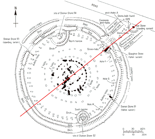
Image - UNC Anthropology
Because the equilateral azimuthal projection below is centered on the maximum latitude of the alignment at 53° 33' N, 23° 35' W, the alignment is horizontal on the image. This is the same alignment that is shown on the two maps above. In addition to the cities on the Eastern Seaboard and the ancient sites listed above, this alignment also crosses over a number of other major cities of the modern era, including Mexico City, the national capital of Mexico; Mobile, Alabama; Atlanta, Georgia; London, the national capital of England; Lille, France, Stuttgart and Munich in southern Germany; Zagreb, the national capital of Croatia; Belgrade, the national capital of Serbia; Sofia, the national capital of Bulgaria; Beirut, the national capital of Lebanon; Damascus, the national capital of Syria; and Riyadh, the national capital of Saudi Arabia.
Map image - Roger Hedin
http://home.hiwaay.net/~jalison/afterword.html |
|
|
|
Rispondi |
Messaggio 11 di 62 di questo argomento |
|
|
|
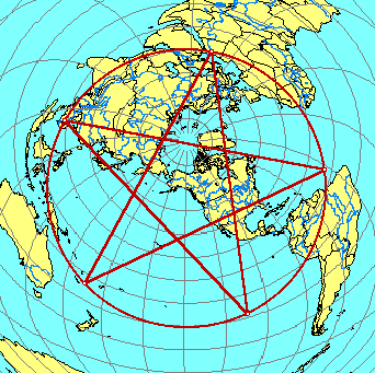
Whitney Houston ¿nueva víctima de los illuminati?Estamos tras la puerta del universo como bien decia Tesla, sobre el 3, 6, y el 9, hay que construir un conocimiento en base a estos conceptos, una buena forma y los Masones lo saben es a través de la geometria. http://es.wikipedia.org/wiki/Toro_(geometr%C3%ADa) Toro (geometría) Para otros usos de este término, véase Toro. En geometría, un toro es una superficie de revolución generada por una circunferencia que gira alrededor de una recta exterior coplanaria (en su plano y que no la corta). La palabra «toro» proviene del vocablo en latín torus, el cual en castellano significa «bocel» o «murecillo», que es una moldura redondeada de la basa, con forma de hogaza de pan.1 2  Si hacemos un corte longitudonal de Toro obtenemos la Vesica Piscis, como siempre los nombres no son elegidos por que si, Benicio del Toro, etc.
 |
Click para ampliar |
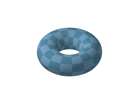 Animación mostrando un toro siendo cortado por un plano, creando Círculos de Villarceau. Ver Vesica Piscis. Juan 6.33 Porque el pan de Dios es el que baja del cielo, y da vida al mundo.
|
Click para ampliar |
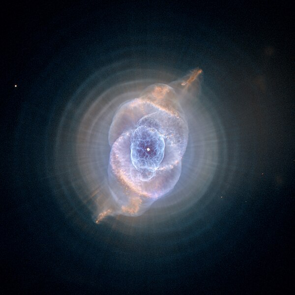
 En cuanto a los cubos de los hipercubos, al juntarse el 9 y el 6 claramente chocan los ejes de los hipercubos, esto en definitiva es lo que produce el fuego y energia para el nuevo ciclo, puedes apreciar como en la forma octogonal el 6 y el 9 rotan sin problemas formando la estrella de 8 puntas, en el octogono mantienen la maxima distancia durante el ciclo, la llamada era dorada que viene despues del cataclismo, codigo de las manzanas doradas en el jardin de las hermanas Hesperides. Estrella binaria - Wikipedia, la enciclopedia libreSistema binario girando reciprocamente en espiral, se puede apreciar de donde sale la forma geometrica del 6 y el 9, al colapsar los espirales esto números se juntan dando lugar a una nuevo ciclo de tiempo.  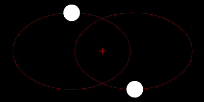 La nebulosa del ojo del gato es un sistema trinario parecido pero con una estrella en el medio, se puede apreciar que dentro de la vesica piscis hay una estrella, otras 2 la orbitan, de allí parte la singularidad, el codigo Mon de la Moon en Ingles Luna, codigo Da Vincia de la Mona Lisa, etc. De alli como fractales nuestros siete dias, que son las siete vidas del gato, etc.
|
Click para ampliar |
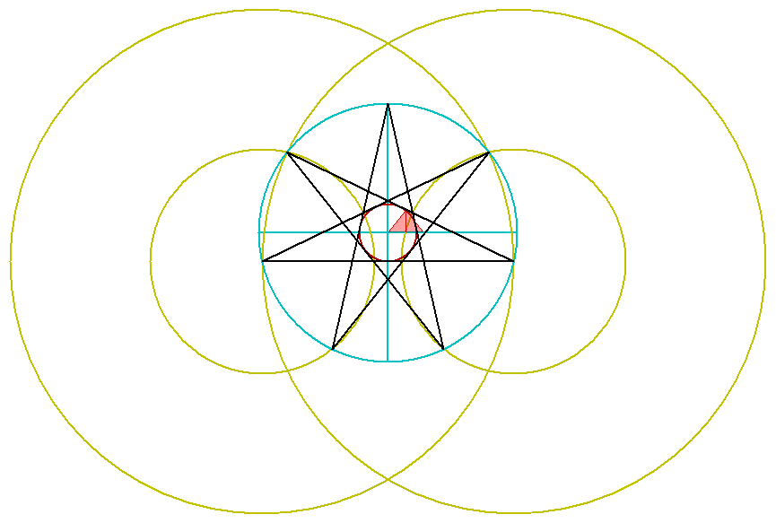
 Construccion el heptragrama
|
Click para ampliar |
|
Click para ampliar |
 En celeste tenemos enl heptagrama el cual coincide con el angulo de la gran piramide 360/7 =51.42 Podemos ver como la base el heptagrama es la gran piramide de Egipto, estos son los fractales del centro de la galaxia que producen nuestros siete dias, 28 dias del mes lunar, etc. Por lo tanto la gran piramide representa la singularidad geometrica, las bases representas los ciclos Alfa y Omega, cuando cambie nuestro espiral 6 a 9 y se inviertan la rotacion de los cubos, la precesion de los equinoccios llegara hasta la puerta de Leo, mas 90 grados llegamos a Omega, el mismo proceso a la inversa. Recordemos Omega - Libra - Lyra - las monedas de los imperios - Dios Apolo y su instrumento.
Última edición por IndigoMerovingio; 08-abr-2012 a las 17:18
|
|
|
|
|
Rispondi |
Messaggio 12 di 62 di questo argomento |
|
|
Grandísimo Gurú burbujista
|
|
Fecha de Ingreso: 07-abril-2008
Ubicación: Cerca de mi casa
Mensajes: 3.546
Gracias: 6.979
3.252 Agradecimientos de 1.503 mensajes
Ignorar usuario para siempre
|
|
Interesante hipótesis si Gizah además de ser un reloj que marca el paso entre eras, señala además alineaciones referidas al mito de una inundación global  
|
Click para ampliar |
 The specific placement of the Giza complex on the 30th parallel The specific placement of the Giza complex on the 30th parallel has long led people to suspect that it was constructed at that location according to deliberate geodetic placement. Piazzi Smyth suggested that the Giza complex identified an ancient 'meridian' as long ago as 1864. The latitude of Giza at 30° N, has been shown to have a geometric relationship with other sacred Egyptian complexes (see above), which in itself is suggestive of a deliberate geometric system of placement. However, the latitude of 30° has its own geometric significance, representing 1/3rd of the way from equator to pole and a 1/12th division of the circumference of a circle. This division can be seen in both the measure of time and space (there are 12 solar months in the year, 24 hours in each day, and 12 astrological signs in the heavens).
 http://www.ancient-wisdom.co.uk/Imag...rthpyramid.jpgThe Great Pyramid of Giza is also a 43,200 scale representation of the outline of the northern hemisphere of the earth (Right). http://www.ancient-wisdom.co.uk/Imag...rthpyramid.jpgThe Great Pyramid of Giza is also a 43,200 scale representation of the outline of the northern hemisphere of the earth (Right).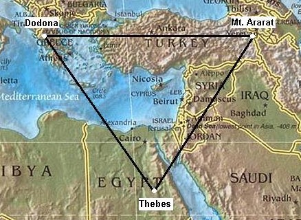 http://www.ancient-wisdom.co.uk/Imag.../karnakmap.jpg http://www.ancient-wisdom.co.uk/Imag.../karnakmap.jpgThe alignment of sites from Giza (Heliopolis) is not restricted to the 30th parallel as geometric alignments have been shown to extend from both Giza (Heliopolis) and Karnak (Thebes), to other sacred sites beyond Egypt. The example already demonstrated above between Giza and Baalbek, is in fact only a part of a larger alignment which extends for almost exactly 1000 miles directly towards Mount Ararat (as first observed by Livvio Stecchini). While these long distance alignments are notoriously difficult to trace, the Giza (Heliopolis) - Baalbek (Heliopolis) section of the alignment is reinforced by supporting evidence; Namely, both sites were equinoctial, they both show the same incredibly skilled masonry techniques, and they are separated by almost exact degrees of longitude and latitude, Baalbek being located 4° North and 5° East. The extreme length of this alignment would normally preclude it from investigation, but in this case, there is supporting evidence which makes it worth a closer look. Stecchini has already made a strong case for the connections between oracle centres and Egypt, with Karnak (Thebes) being the oracular centre and 'earth-navel' of ancient Egypt, as testified by the 'Omphalos' discovered at Karnak. It is significant then that Dodona in Greece is both named as the oldest oracle centre in Greece (with a connection to Thebes supported by Herodotus), as the landing place for Deucalion following the 'Flood of Deucalion' in Greek mythology, while Ararat is clearly named as the landing place for the Ark in the Old Testament, as they both share the same latitude...and are located equidistant from Thebes.Prehistoric Egyptian Geodesy.Dodona in Greece is also aligned with Delphi and Behdet (the prehistoric capital of Egypt according to Stecchini) in what he called the 'Oracle Octave'. Significantly, Stecchini stated that the pre-dynastic capital of Egypt, Behdet 'existed before 3,200 BC', and was replaced by the city Canopus, (The same name as the star that represents the 'rudder' of the constellation Argo). He suggested that this was the key to the connection between the two mythological narratives of the ‘Ark’ of the Hebrews and the ‘Argo’ of the Argonauts, which he believed, revealed evidence of a prehistoric system which included an understanding of astronomy and geometry (in the sense earthly measurements).An alignment is commonly said to run from Giza to the Boyne-Valley, Ireland. Although the accuracy of this alignment is debateable, it nevertheless passes several of the most important places in Europe, both past and present: From Giza it runs north-west towards Rome (Vatican city), Zurich, Paris (Par-Isis), the Salisbury complex and on to the Boyne Valley. Pateo.nl : Wholly Science |
VER VIDEO
|
|
|
|
Rispondi |
Messaggio 13 di 62 di questo argomento |
|
El 21 de Diciembre coincide con el codigo de Jesus, su muerte y resurreccion 3 dias despues, el dia 24 o Navidad.
Sabemos que los Mayas conocian los codigos y sus calendarios eran muy exactos, si conocía la fecha con exactitud es un misterio.
Lo que he expuesto como mayor prueba de que estamos cerca de este acontecimiento es el componente magnetico del hipercubo a 60 grados, lo cual fue confirmado por el Voyager fuera del sistema solar, en realidad deberia ser inferior a 60, 59,9.. o simil ya que la forma hexagonal del hipercubo es incompatible con el fluido del tiempo, los cubos se fusionan al chocar el 9 y el 6, de 16 puntos de la matriz pasamos a 15, numero impar por lo tanto se pierde polaridad.
Por que 33, el misterioso numero? Simplemente por que 4/3 = 8/6 =1.33, 8 el octogono del orden conformado por 2 cubos sobre el hexagono como el caos.
El punto medio entre ambos simboliza el pasaje entre la muerte y la resurreccion, los 3 dias de noche, el sol negro, etc.
|
Click para ampliar |
|
Click para ampliar |
 El corte grafico 8/6 desde un extremo la singularidad del octogono en el centro de la galaxia a 33 grados y la componente medio de Virgo/Virgen a medio Piscis/Jesus desde la circunferencia exterior pasando por el centro.
|
Click para ampliar |
 Las calles de Washington reflejan el octogono o la nueva era dorada.
|
Click para ampliar |
|
Click para ampliar |
|
Click para ampliar |
 Fractales de tiempo del octogono regenerativo-24 horas del dia 8 octogono/33 = 0.242424 8 octogono/33.333..=0.2400024 800/33.333=24.00024 La lineas amarillas que alternan en 33 grados tienden y por lo tanto median hacia la semilla de la flor octogonal en verde del toro geometrico comprendido en el hipercubo.
|
Click para ampliar |
|
Click para ampliar |
|
Click para ampliar |
|
Click para ampliar |
Última edición por IndigoMerovingio; 12-nov-2012 a las 19:24
|
|
|
|
Rispondi |
Messaggio 14 di 62 di questo argomento |
|
|
|
|
Rispondi |
Messaggio 15 di 62 di questo argomento |
|
|
|
|
|
www.youtube.com/watch?v=XZ...19 Mar. 2012 - 23 min. - Subido por SamuelLaboy
THE FACT THAT THE GEOMETRY OF THE VESICA PISCIS GIVES US .... Modern ... |
Paul Michell and Charles Henry have noted the relationship between the Great
Pyramid and the Vesica Pisces. The small circles in this diagram are one inch in ...
(Full descriptive analysis of the Giza plateau and the Great pyramid). Historical
..... The exterior angle of the great pyramid can be formed with the vesica-pisces.
23 Jul 2002 ... Linking The Great Pyramid to the Human Form ... The Vesica Piscis is one of the
most fundamental geometrical forms of this ancient discipline ...
12 Oct 2006 ... The Great Pyramid and the 153 Fish in the Net. According to John, Jesus ... The
Pythagoreans called this shape vesica piscis. The ratio of the ...
31 Oct 2009 ... A fact which appears to connect the operation of the great Pyramids in ... Step 1,
arrange two circles in the so called “Vesica Piscis” where the ...
www.grahamhancock.com/forum/AlisonJ1-p4.htm - En caché
Paul Michell and Charles Henry have noted the relationship between the Great
Pyramid and the Vesica Pisces. The small circles in this diagram are one inch in ...
www.slideserve.com/lali/sacred-geometry - En caché
14 Apr 2012 ... Vesica Piscis. 18. Vesica Piscis and Relationship to Great Pyramid. 19. Vesica
Piscis and Relationship to Gothic Arch. 20. Vesica Piscis and the ...
forum.tarothistory.com/viewtopic.php?f=12&t=438&p... - En caché
28 Mar 2010 ... By utilizing the seked proportion used for the Great Pyramid, the ... to the Great
Work thru its' completion of a matrix for the vesica piscis ...
books.google.com.ar/books?isbn=1442961074
Was there any relationship between the Vesica Piscis and the Great Pyramid?
The Great Pyramid is also created using sacred geometry—the approximate 52° ...
|
|
|
|
Rispondi |
Messaggio 16 di 62 di questo argomento |
|
|
PART 4 - THE GREAT PYRAMID AND THE 30th PARALLEL
|
This circle has a different orientation than the previous diagrams and is two inches in diameter.
The horizontal axis is the Equator, FC is the 30th parallel, D is 60� North latitude and E is the North Pole.
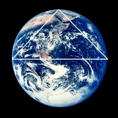
The 30th parallel is exactly one-third of the great circle distance from the Equator to the North Pole, and it is located at exactly one-half of the height of the Northern Hemisphere.
Like the Great Pyramid, the maximum latitude of the line of ancient sites is very close to the 30th parallel.
|

|
|
|
This diagram illustrates that the relationship of the 30th parallel to the circumference of the Earth is the geometric relationship known as the Vesica Pisces.
In relation to the lower circumference, DE is at 30� N latitude.
In relation to the upper circumference, DE is at 30� S latitude.
The ratio between the straight line distance of the 30th parallel and the radius of the Earth is 1.732 to one. 1.732 is the square root of three.
|
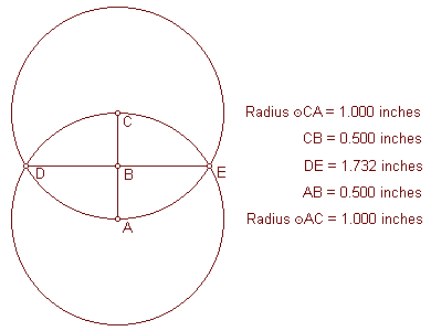
|
Paul Michell and Charles Henry have noted the relationship between the Great Pyramid and the Vesica Pisces.
The small circles in this diagram are one inch in diameter, and the large circles are three inches in diameter, forming a small Vesica Pisces circumscribed by a larger one.
The triangle in this diagram has the same angular dimensions as the Great Pyramid.
|
|
|
|
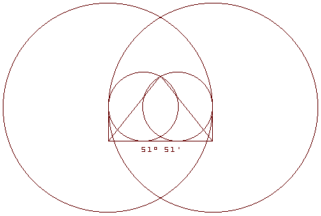
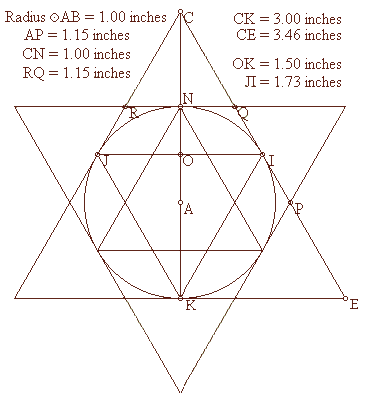
The circle in this diagram also represents the circumference of the Earth with the poles on the vertical axis.
The radius of the circle is 1.00 inch.
The exterior and interior equilateral triangles touch the circle only at the 30th parallels and the poles.
The height of each equilateral triangle is 87% of the length of each of it’s sides:
3.00 � 3.46 = .87
1.50 � 1.73 = .87
1.00 � 1.15 = .87
The length of each of the sides of the interior triangles, including the straight line distance through the earth at the 30th parallel, is also 87% of the diameter of the Earth:
1.73 � 2.00 = .87
|
The radius of the Earth is also 87% of the distance from the center of the Earth to the point of the exterior triangles’ intersections (AP, AQ, AR, etc.):
1.00 � 1.15 = .87
The Greek foot is thought to have been developed before the size and shape of the Earth was known and independently from the foot, which is also thought to have been developed before the size and shape of the Earth was known. The foot is 87% of the length of the Greek foot.
The mile, which is thought to have been developed before the size and shape of the Earth was known, is 87% of the length of the nautical mile, which was developed specifically in relation to the size of the Earth. The nautical mile equals one minute of latitude, so 60 nautical miles equals one degree of latitude and 5,400 nautical miles equals the 90 degrees of latitude between the Equator and the poles.
The distance from the Equator to the poles is 6,215 miles:
5,400 � 6,215 = .87
One minute of latitude equals one nautical mile at any longitude.
At the equator, one minute of longitude also equals one nautical mile, but at higher latitudes, the distances between each minute of longitude become shorter. Because the straight line distance through the Earth at the 30th parallel is 87% of the diameter of the Earth, the circumference around the Earth at the 30th parallel is 87% of the circumference of the Earth at the Equator, and each minute of longitude at the 30th parallel is 87% of the distance of each minute of longitude at the Equator. As a result, just as one nautical mile equals one minute of longitude at the Equator, one standard mile equals one minute of longitude at the 30th parallel.
The currently accepted value for the Equatorial diameter of the Earth is 7,926 miles, with an Equatorial radius of 3,963 miles. The ratio of the radius of the Earth to the straight line distance through the Earth at the 30th parallel is 1:1.732.
3,963 miles x 1.732 = 6,864 miles (the straight line distance through the Earth at the 30th parallel).
6,864 miles x pi = 21,564 miles (the circumference of the Earth at the 30th parallel).
21,564 miles � 360 degrees = 59.9 miles (one degree of longitude at the 30th parallel).
59.9 miles � 60 minutes = .998 miles (one minute of longitude at the 30th parallel).
As an alternative proof, the currently accepted value for the Equatorial circumference of the Earth is 24,902 miles, and the circumference of the 30th parallel is 87% of the circumference of the Earth.
24,902 miles x .87 = 21,664 miles (the circumference of the Earth at the 30th parallel).
21,664 miles � 360 degrees = 60.1 miles (one degree of longitude at the 30th parallel).
60.1 miles � 60 = 1.00 miles (one minute of longitude at the 30th parallel).
Conclusion: One minute of longitude equals one mile at (or, like the Great Pyramid, just below) the 30th parallel.
Back to Contents
|
|
|
|
Rispondi |
Messaggio 17 di 62 di questo argomento |
|
|
|
 Primo
Precedente
3 a 17 de 62
Successivo Primo
Precedente
3 a 17 de 62
Successivo Ultimo
|
|
| |
|
|
©2025 - Gabitos - Tutti i diritti riservati | |
|
|


")
")
")