|
|
GIZE, STONEHENGE, CHICHEN ITZA, ETC,ETC: PIRAMIDES DE TUCUME Y PARATOARI (PERU)
Escolher outro painel de mensagens |
|
|
|

por Max Tafur
del Sitio Web AndeSenios
|
Aunque poco divulgado, uno de los enigmas que ha ocupado a muchos científicos en el último tiempo son las llamadas Pirámides Peruanas. Son formaciones que, en apariencia, pueden haber sido creadas por causas naturales, pero las investigaciones apuntan a que por su ubicación y formas, se trata de obras humanas. ¿Su función? Ese es el misterio que aún se intenta revelar.
|
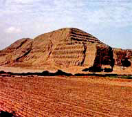
Las pirámides peruanas están construidas con adobes.
Se ha estimado que se usaron 140 millones de adobes en la construcción de la Huaca del Sol. Las pirámides no fueron construidas en un solo momento, sino que sufrieron muchas modificaciones y ampliaciones hasta tener los volúmenes actuales.

El arqueólogo norteamericano Moseley ha visto en la Huaca del Sol el corte 8 etapas en las que se construyó el monumento. El volumen de la pirámide (a lo largo, ancho y alto) era ampliado construyendo grandes columnas de adobes adosadas unas a otras.
Los adobes
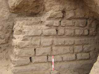
Los adobes para la construcción de las pirámides, en particular para la Huaca del Sol y otras de Moche (como la de Sipán o El Brujo) tienen 2 características importantes: eran hechos con moldes y tenían la marca del fabricante.
La fabricación con moldes permitía tener adobes con las mismas dimensiones y calidad. En la cara superior del adobe se hacían unas marcas. Estas eran puntos y rayas, o aspas. Se cree que las marcas corresponden a la comunidad que los fabricó, y que servían para controlar la cantidad de adobes con los que contribuían en la construcción de la Huaca. En El Sol se han encontrado por lo menos 96 marcas distintas.
En base a los estudios de la arcilla de los adobes, se ha determinado que secciones enteras de la Huaca están construidas con adobes provenientes de una misma cantera, y tienen un mismo tipo de marca.
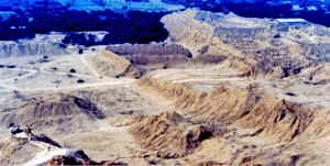
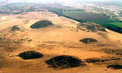
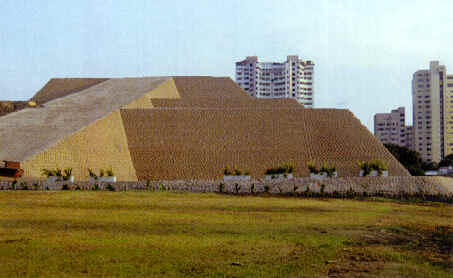
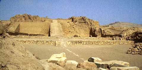
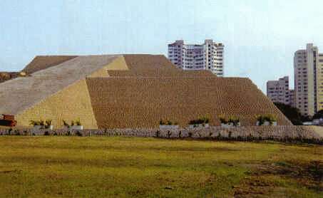
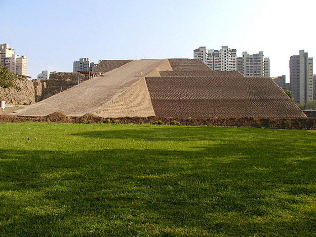
Pirámides de Túcume
Las pirámides de Túcume son notables por su extraordinario tamaño: según estimaciones, más de 130 millones de ladrillos de adobe secados al sol fueron necesarios para construir la más grande de 450 m de largo, 100 de ancho y 40 de altura.
A diferencia de las de Egipto, las pirámides de América del Sur y Central no poseían puntas, pero sí grandes plataformas donde se situaban los templos.
Según mitos y leyendas, cada peldaño representaba una fase de desarrollo en la vida humana, la cual tenía que ser disfrutada plena e integralmente. La subida era penosa y al llegar a la cima, se lograba un espíritu elevado y la ceremonia en aquel tiempo era un acontecimiento festivo en la vida de aquellos seres humanos.
La cultura Moche se desarrollo principalmente en la costa Norte del Perú en los departamentos de Lambayeque y La libertad, Aunque sus manifestaciones llegan hasta los departamentos de Piura por el Norte y Ancash por el Sur. Se trata de una cultura básicamente costera, que se asienta en una región única en el Perú donde la costa es bastante mas ancha que en el resto del litoral peruano, donde los valles suelen ser bastante angostos y de poco potencial agrícola.
Al ser esta costa de mayor tamaño permite la formación de valles sumamente productivos por la cantidad de agua y facilitando la aparición de manifestaciones culturales de gran envergadura como las Moche.
"Cuando vine cruzando el bosque de algarrobos aislados de cultura, pensé que estaba soñando. Nunca había visto algo así antes... el más grande complejo de estructuras monumentales de adobe en el nuevo mundo: 26 grandes pirámides y muchas otras menores agrupadas dentro de un sitio sagrado de 500 acres. Me sentí literalmente de otro planeta, no había nada como estas extrañas y colosales ruinas en nuestra propia y familiar tierra".
Así describió Túcume el aventurero noruego Thor Heyerdahl (quien en 1947 logró llegar en una balsa, el famoso Kon Tiki, desde el puerto del Callao hasta las islas de la polinesia), en 1987 cuando el arqueólogo Walter Alva lo llevó al sitio.
Túcume se encuentra en la llanura costeña del norte del Perú, privada de lluvias por la elevada cordillera de los Andes salvo los años de Niño donde la abundancia y la brutalidad de las precipitaciones pueden destruir un pueblo entero como fue el caso del actual Túcume Viejo, abandonado por sus habitantes en el siglo XVI a consecuencia de un destructor fenómeno de "El Niño".
Túcume se inició durante el período clásico de la cultura Sicán, convirtiéndose en el más importante centro urbano de la región. Por ello, los conquistadores Chimu e Inca lo escogieron como centro de su poder político administrativo.
Las pirámides de Túcume son notables por su extraordinario tamaño: según estimaciones, más de 130 millones de ladrillos de adobe secados al sol fueron necesarios para construir la más grande de 450 m de largo, 100 de ancho y 40 de altura. A diferencia de las de Egipto, las pirámides de América del Sur y Central no poseían puntas, pero sí grandes plataformas donde se situaban los templos.
Según mitos y leyendas, cada peldaño representaba una fase de desarrollo en la vida humana, la cual tenía que ser disfrutada plena e integralmente. La subida era penosa y al llegar a la cima, se lograba un espíritu elevado y la ceremonia en aquel tiempo era un acontecimiento festivo en la vida de aquellos seres humanos.
Al igual que los demás conjuntos monumentales chimus o mochicas y junto con Batan Grande, Túcume fue relacionado por los arqueólogos con los grandes sistemas hidráulicos y los centros de poder político y religioso de la región.
Un conjunto de mitos siguen asociados al sitio (como la leyenda que evoca la existencia de una raya atrapada en el cerro al centro del conjunto, huella de los dioses del pasado y que hacen de éste un cerro encantado) lo que dificultó mucho las labores de investigación arqueológica, demostrando que las creencias forjadas en el período precolombino siguen profundamente enraizadas a siglos de desaparecidas las condiciones socio-económica de su construcción.
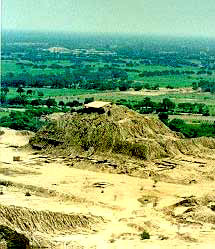
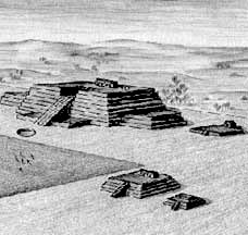
Pirámide de la Luna
En esta hipotética reconstrucción, la Huaca de la Luna muestra su imponente imagen durante el apogeo de la cultura Moche, con sus plataformas escalonadas y altorrelieves de colores por los cuatro costados. Sus patios ceremoniales y recintos fueron exclusivamente destinados al uso ritual y funerario.
De no ser por su cerámica y su rica iconografía, poco se supo de los moches hasta fines de la década pasada, cuando el hallazgo de la fastuosa tumba del Señor de Sipán, los murales del complejo arqueológico de El Brujo, en el valle de Chicama, y las investigaciones en la Huaca de la Luna, sirvieron para reconstruir el esplendor de una de las culturas más creativas y pujantes del mundo americano antiguo.
Un proceso denominado por historiadores como el renacer de los Mochicas.
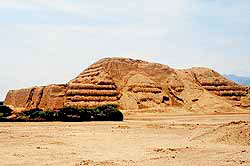
Pirámide del Sol
La HUACA DEL SOL, vista desde la Huaca de la Luna separadas por la extensa planicie ceremonial. Al fondo la extensa campiña y el río Moche.
La huaca del Sol delimita la zona de la campiña. Las estimaciones más precisas sostienen que la Huaca del Sol tuvo más de 55 mil metros cuadrados de área (345 x 160 metros) y treinta metros de altura, y que en su construcción se usaron no menos de 140 millones de ladrillos.
La zona fue el epicentro ceremonial de la cultura Moche, que en pleno apogeo abarcó los actuales territorios de Piura, Lambayeque, La Libertad y Ancash, hasta el puerto de Huarmey. Incluso, ahora se sabe que el nombre de Huaca del Sol se debe a una errónea interpretación de los cronistas españoles y que su verdadero nombre habría sido Capuxaida.
Pirámides de Caral
La ciudad más antigua de América se encontraba en el norte del Perú, en Caral, según las pruebas científicas, tiene una antigüedad promedio entre 2.627 y 2.100 antes de Cristo aproximadamente. Al mismo tiempo que Egipto florecía a orillas del Nilo, 5.000 años atrás, una cultura similar en complejidad empezaba a despuntar en Perú, donde los arqueólogos han encontrado los restos de la civilización más antigua de América.
El lugar de nacimiento de la civilización americana: Caral posee algunos de los mayores edificios encontrados en el valle de Supe, con plataformas en las que caben dos estadios de fútbol y construcciones de cinco plantas.
No hay en América otro sitio que tenga similares características sino hasta 1000 ó un área mucho mayor que la del valle de Supe (al norte de Lima), y que había construido asentamientos de tipo urbano a lo largo de este valle.
Caral tiene una antigüedad promedio entre 2.627 y 2.100 años antes de Cristo aproximadamente y dijo que en el resto de América "el desarrollo urbano comienza 1.550 años después que en Perú. En Caral, fueron halladas pirámides de más de 150 metros de planta, muros de hasta 20 metros de elevación y grandes plataformas de piedra, habría tenido entre 500 y 600 años de ocupación.
 Caral rompe "todos los esquemas" que tenían los arqueólogos respecto a que las civilizaciones complejas sólo pueden florecer en un período en el que exista la cerámica. Caral rompe "todos los esquemas" que tenían los arqueólogos respecto a que las civilizaciones complejas sólo pueden florecer en un período en el que exista la cerámica.
A diferencia de otros sitios del período arcaico lo importante de Caral es que es monumental, por eso nadie creía que era del pre-cerámico. Caral, tiene más de 65 hectáreas de extensión y desde 1996 los arqueólogos peruanos iniciaron las excavaciones de las 32 estructuras piramidales.
Se ha excavado hasta la fecha tres estructuras piramidales de diferente rango, extensión o tamaño y estamos excavando cuatro sectores residenciales, diferenciados por su ubicación, por su tamaño y la calidad del material constructivo.
Caral, precisó, tuvo a diferencia de las sociedades agrícolas de su época una economía mixta que se sustentaba en actividades agrícolas y pesqueras, sus habitantes consumieron grandes cantidades de anchoveta y hubo un intenso comercio del algodón.
En Caral se han encontrado "productos de la sierra y de la selva", lo que demuestra que hubo un "intercambio sostenido" a pesar de las dificultades para la comunicación en un territorio como el área del norte centro atravesado por la Cordillera de Los Andes.
Pirámides de Paratoari
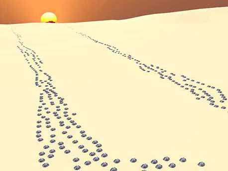
Hacía la tarde del 30 de diciembre de 1975, las zonas del parque nacional del Manú era fotografiada por el satélite geoestacionario de la N.A.S.A. Landsat II, el cuál se encargaba de explorar los sectores selváticos de esta reserva del Perú.
Para sorpresa de los científicos una de sus fotografías denotaba la extraña presencia de unos puntos perfectamente simétricos que se extendían en un diámetro aproximado de 3 kilómetros en la cordillera del Pantiacolla (una de las últimas estribaciones andinas).
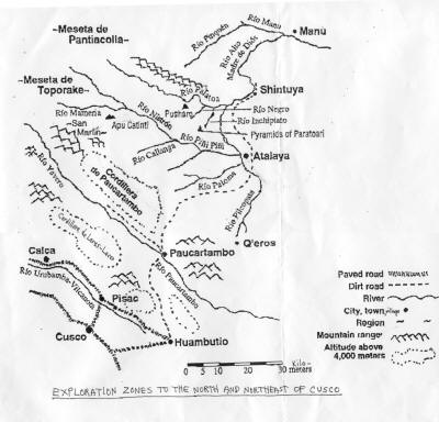
Estos puntos a los que bautizaron "dots", parecían enseñar una geografía bastante diferente -a las accidentadas zonas del Madre de Dios-, ya que se podía llegar a observar lo que al parecer no correspondía a fallas naturales, si no a construcciones increíblemente desarrolladas, y en un sector totalmente inexplorado.
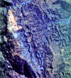
"Pirámides" de Pantiacolla / Paratoari fotografiadas por el satélite SPOT II
© CNES 1998
Al principio la incertidumbre era presa de todos los científicos por lo que decidieron utilizar el método del rayo infrarrojo que lograba captar más que el ojo humano, y el misterio se elevaba cada ves más ya que los dots aparecían de color blanco, demostrando que había algo más indescriptible en esos parajes del bosque tropical.
De esta manera se hicieron análisis de todo tipo tratando de llegar a una conclusión objetiva detrás de tan importante descubrimiento, de esta forma decidieron enviar las fotos satelitales al "Interamerican Geographic Institute" donde el ingeniero cartográfico A.T. Tizando recalcó lo sorprendente de las estructuras y defendió la teoría de que no podían haber sido creadas por la naturaleza, si no por el hombre.
Bibliografía
-
José Canziani Amico. Asentamientos Humanos y Formaciones Sociales en la Costa Norte del Antiguo Perú. Instituto de Estudios Andinos (INDEA). 1989. Lima - Perú.
-
Ruth Gallardo C. y Jorge Narro Carrasco. "Revisión de la Arquitectura de la Huaca del Sol. Sección 2". Revista del Museo de Arqueología N. 4.Facultad de Ciencias Sociales, Universidad Nacional de Trujillo. 1993. Perú.
-
Markus Reindel. "Arquitectura Monumental del Intermedio Temprano de la Costa Norte del Perú". Revista del Museo de Arqueología N. 1. Facultad de Ciencias Sociales, Universidad Nacional de Trujillo. 1990. Perú.
|
|
|
|
|
Lambayeque - Valley of the Pyramids
Lambayeque Valley is located in sub-Andean region in North Peru, 800km (497 miles) from Lima. This area was populated by the Lambayeque/Sican (Sicán o Lambayeque) (approx. 1000-1350 AD), then by the Chimú (1350-1450 AD), and later was conquered and ruled by the Incas.
Lambayeque Valley is also known as “The Valley of the Pyramids”, as there are 250 pyramids in the valley – one of the most stunning pyramid sites in the world. The archaeological excavations are ongoing in this valley and the archaeologists continue to uncover more pyramid complexes.
Legends of the Valley of the Pyramids
Lambayeque Valley infamous amongst the local population; they are fearful of these places, considering them cursed. However, the local shaman healers invoke the powers of the valley in their many rituals.
The three ancient cities were built in succession of each other in the valley: Pampa Grande, Butan Grande and Túcume. Each city was abandoned before a new one was built. For some reason the buildings on the pyramids were burnt and the town abandoned, to be succeeded by the next one.
The oldest city is known as Pampa Grande. There is only one pyramid in this city.
The next complex was that of Batan Grande built by Lambayeque civilization and had 6 pyramids. The last of the cities Túcume, covers an area of 2.5 km2 (540+ acres) and encompasses 26 major pyramids and platforms. The massive central pyramid of the city – the Huaca Larga, is the longest adobe structure known to date. It measures 700 metres (2297 feet) in length, 280 metres (919 feet) wide, and thirty metres (98 feet) tall (this is the size of seven football (soccer) fields). Inside the burial chambers under the pyramid, 119 bodies were found which are assumed to have been sacrificed.
Discoveries in the pyramids indicate that the pyramids at Túcume served as places of residence, like a palace for the lords who governed the whole area. Archaeologists believe the likely explanation is the lords on these pyramids were rulers from across this valley. If you look around all the pyramids at Túcume, consider each one of them would have had some kind of lord living on top. Lambayeque, as other Andean civilization, believed that the truly powerful gods lived in the mountains. When the Lambayeque built a pyramid they were building a replica mountain with the same supernatural power they hoped could control the forces of nature. And just as the gods lived on the mountains, the lords would live on top of these pyramids to protect the people from what they most feared.
But what was it in this valley they were so afraid of?
This region has been subject to some of the most extreme climate disasters on the planet. These disasters were caused by the violent climate upheavals known as El Niños. Floods, sand storms, droughts - for the Lambayeque these climate disasters could only be understood as the wrath of the angry gods. When the pyramids failed to protect against catastrophe they had to be purged by fire and abandoned. And new and more pyramids built to replace them. It suggests this is why the valley is littered with the ruins of so many abandoned pyramids.
Arrival of Spanish occupants in the beginning of the 16th century, who killed the Incan god-king (by the time the Spanish arrived in South America, the Lambayeque valley had fallen under the control of the Incas), made the Túcume people believe that the Spanish, these violent invaders, were a sign of the anger of the gods. So the people of the valley made their last attempt to please the gods. 119 humans were ritually executed outside the temple of Túcume. From the cut marks, scientists can piece together an exact, blow-by-blow account of how these people were sacrificed. Before execution they had been drugged with a seed called Amalla. They contain a drug that paralyses the body but leaves the victim conscious, able to understand and feel everything that's happening to them. The people who were taken to be sacrificed in front of the temple didn't put up any resistance to their death because they had previously consumed a large quantity of Amalla. After the throat had been cut, the priest then cut open the chest cavity and the victim's heart was ripped out.
But the mass of human sacrifices had failed to protect the people. They have left the city. The Valley of Pyramids was abandoned.
How to get there
Túcume is 33 km (21 miles) from Chiclayo and 800km (497 miles) north of Lima (10 hrs by bus). You can catch a bus in Av. Manuel Pardo y Angamos in Chiclayo .
|
|
|
|
|
THE ANCIENTS
Pyramids Around the World |
Inca Pyramids
Huallamarca, Peru
..
Huallamarca Pyramid
..
Huallamarca Pyramid - Courtesy of Luis Montero
Inca Pyramids in Peru
Peru is a spiritual land where pyramids can be found. The pyramids of Peru had the same functions as those found in other areas of the planet where once great civilizatons existed. Most were used as places of worship to the Gods having rituals (at various equinoxes and solstices) - and ceremonial rites of various kinds. Theories about the Pyramids in Peru place their creation in the same timeline as the Nazca Lines.
Many of these pyramids had flat tops looking much like those found in Mexico. Often they were built on a place where the Earth energies were high - specific grid points following the measurements of Sacred Geometry.
Pachacamac, Peru
..
Pachacamac Pyramid
..
Pachacamac Pyramid - Courtesy of Javier Delgado
..
Tecume, Peru
..
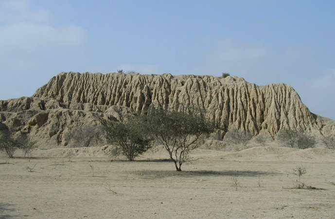
An eroded pyramid at Tucume - Courtesy of Northern Andes Expedition
Rumors of a vast hoard of gold prompted famous Norwegian scientist and explorer Thor Heyerdahl to investigate the area around Tucume in northern Peru. The result was the archaeological discovery of 26 pyramids. Forty tombs pre-dating the arrival of the Spaniards were opened, and enough Inca and Chimu artifacts unearthed to justify the building of a museum at Tucume. Four burial chambers in the 600 meter long Huaca Larga pyramid were excavated. Inside the burial chambers the bodies of 16 female weavers sacrificed to the gods. The area near Tucume consists of 26 massive pyramids which suggest a civilization that flourished in the now endless desert for perhaps more than 1,500 years.
..
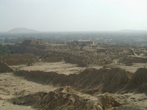
Ruins of the huge compound of Huaca Grande at Tucume - Courtesy of Northern Andes Expedition
Purgatorio (purgatory) is the name by which local people refer to the dozens of prehispanic pyramids, enclosures and mounds found on the plain around La Raya Mountain, south of the La Leche River. This is the site of Tucume, covering an area of over 540 acres and encompassing 26 major pyramids and platforms.
..
Some of the 26 eroded adobe pyramids at Tucume - Courtesy of Northern Andes Expedition
|
|
|
|
|
|
|
Pyramids in Peru
Stunning Astronomical Alignment Found at Peru Pyramid Live Science - May 6, 2013
An ancient astronomical alignment in southern Peru has been discovered by researchers between a pyramid, two stone lines and the setting sun during the winter solstice. During the solstice, hundreds of years ago, the three would have lined up to frame the pyramid in light. The two stone lines, called geoglyphs, are located about 1.2 miles (2 kilometers) east-southeast from the pyramid. They run for about 1,640 feet (500 meters), and researchers say the lines were "positioned in such a way as to frame the pyramid as one descended down the valley from the highlands."
Archaeologists have discovered a pyramid in southern Peru, built between 600 B.C. and 50 B.C. ago, would have aligned with two stone lines and the setting sun during the winter solstice. Here, a 3D model shows the event that happened at the Cerro del Gentil pyramid during the winter solstice. The two stone lines frame the pyramid with the sun setting directly behind it. This alignment may have had cosmological significance for the people who lived there. An ancient astronomical alignment in southern Peru has been discovered by researchers between a pyramid, two stone lines and the setting sun during the winter solstice. During the solstice, hundreds of years ago, the three would have lined up to frame the pyramid in light. The two stone lines, called geoglyphs, are located about 1.2 miles (2 kilometers) east-southeast from the pyramid. They run for about 1,640 feet (500 meters), and researchers say the lines were "positioned in such a way as to frame the pyramid as one descended down the valley from the highlands." Using astronomical software and 3D modeling, the researchers determined that a remarkable event would have occurred during the time of the winter solstice. "When viewed in 3D models, these lines appear to converge at a point beyond the horizon and frame not only the site of Cerro del Gentil where the pyramid is, but also the setting sun during the time of the winter solstice," the research team wrote in a poster presentation given recently at the Society for American Archaeology annual meeting in Honolulu.
Mysterious Pyramid Complex Discovered in Peru
National Geographic - February 22, 2008
Remnants of at least ten pyramids have been discovered on the coast of Peru, marking what could be a vast ceremonial site of an ancient, little-known culture. In January construction crews working in the province of Piura discovered several truncated pyramids and a large adobe platform. Officials from Peru's National Institute of Culture (INC) were dispatched to inspect the discovery.
Last week they announced that the complex, which is 2 miles (3.2 kilometers) long and 1 mile (1.6 kilometers) wide, belonged to the ancient Vicus culture and was likely either a religious center or a cemetery for nobility. The Vicus was a pre-Hispanic civilization that flourished in Peru's northern coastal desert from 200 B.C to 300 A.D. and is known for its decorated ceramics. Experts say little is known about the culture, because its sites have been heavily looted over the years. "We found several partial pyramids, at least ten," said Cesar Santos Sanchez, chief archaeologist for INC's Piura division. "We also found a large adobe platform that we speculate could have been used for burial rituals. But we cannot know without further testing."
Skull Fragments: The platform, measuring 82 feet (25 meters) by 98 feet (30 meters), was found alongside one of the larger pyramids in the complex. Another of the larger pyramids contained some artifacts as well as bone fragments from a human skull. The fact that the skull fragments were found several meters below the surface, indicating a deep grave that took much time to dig, prompted researchers to theorize that the individual buried there had high social status.
Ancient "Lost City" Discovered in Peru, Official Claims National Geographic - January 16, 2008
Ancient pyramids in Peru had the same functions as Pyramids found in other ancient civilizations around the world. Most were used as places to worship their Gods and Goddesses - rituals (at various equinoxes and solstices) - ceremonial rites of various kinds. They were generally built major planetary and energetic grid points
Huallamarca Pyramid
This imposing monument has remained impervious to the ravages of time, and modern civilization and stands surrounded by the asphalt jungle. The two-story construction is made of adobe with a steep ramp leading to the upper level. Archaeological excavations have unearthed mummies on display with ancient objects inside the on-site museum.
Photo Gallery
Tucume
Rumors of a vast hoard of gold prompted famous Norwegian scientist and explorer Thor Heyerdahl to investigate the area around Tucume in northern Peru. The result was the archaeological discovery of 26 pyramids. Forty tombs pre-dating the arrival of the Spaniards were opened, and enough Inca and Chimu artifacts unearthed to justify the building of a museum at Tucume. Four burial chambers in the 600 meter long Huaca Larga pyramid were excavated. Inside the burial chambers the bodies of 16 female weavers sacrificed to the gods. The area near Tucume consists of 26 massive pyramids which suggest a civilization that flourished in the now endless desert for perhaps more than 1,500 years.
Photo Gallery
Pachacamac Pyramid Project
Ichimay Culture; had a Magic-Religious function of adobe brick. Theories about the Pyramids in Peru place their creation at the same time the Nazca Lines were created. The pyramids had flat tops looking much like those in Mexico.
Photo Gallery
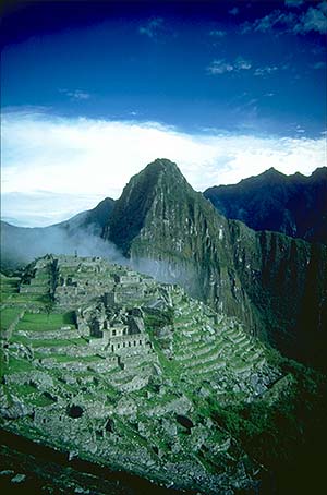
MACHU PICCU
ShareThis
PYRAMID INDEX
SACRED PLACES AND TEACHINGS INDEX
ANCIENT CIVILIZATIONS INDEX
ALPHABETICAL INDEX OF ALL FILES
CRYSTALINKS HOME PAGE
PSYCHIC READING WITH ELLIE
2012 THE ALCHEMY OF TIME
http://www.crystalinks.com/pyramidperu.html
|
|
|
|
|
Túcume is a pre-Hispanic site in Peru, south of the La Leche River on a plain around La Raya Mountain. It covers an area of over 540 acres (220 ha) and encompassing 26 major pyramids and mounds.[1] The area is referred to as Purgatorio (purgatory) by local people.
This site was a major regional center, maybe even the capital of the successive occupations of the area by the Lambayeque/Sican (800-1350 AD), Chimú (1350–1450 AD) and Inca (1450–1532 AD). Local shaman healers (curanderos) invoke power of Tucume and La Raya Mountain in their rituals, and local people fear these sites. Hardly anyone other than healers venture out in this site at night.
The plains of Túcume are part of the Lambayeque Valley, the largest valley of the North Coast of Peru. The Lambayeque Valley is the site of scores of natural and man-made waterways and is also a region of about 250 brick pyramids.
http://en.wikipedia.org/wiki/T%C3%BAcume |
|
|
|
|
 |
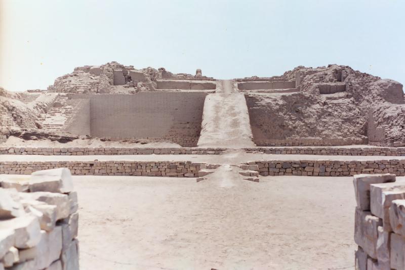
"Huaca Larga", Or The "Long Pyramid",
The Longest Adobe Structure Known, About 2,300 Feet Long. |
 |
| "Huaca One",Or "Pyramid One", About 98 - Feet High. |
The Plains Of Tucume are part of the Lambayeque Valley, the largest valley of the North Coast of Peru. The Lambayeque Valley contains many natural and man-made waterways. lt is also a region of 26 major pyramids and platforms, as well as, many other minor pyramids.
This area was a major population center, perhaps the capital of each of the successive cultures of the area; by the Lambayeque/Sican (1000/1100-1350 AD), the Chimú (1350-1450 AD), and later on the Inca (1450-1532 AD).
Father Cabello de Balboa (1586 AD) recorded local legends concerning the founding of Tucume. According to his writings, Cala, a grandson of the mythical Naymlap, founder of the Lambayeque royal dynasty, is said to have gone to Tucume to "start new settlements, bringing many people him with". The founding of the Tucume area occured in about 1000-1100 AD, when the old regional center at Batán Grande, to the south of the Chancay river, was burnt and abandoned. Tucume quickly rose to a prominent position within the valley.
Tucume, covers an area of 540+ acres and encompassing 26 major pyramids and platforms. The largest and most impressive pyramids of the Plains Of Tucume are found in the archaeological sector, to the north and northeast of La Raya Mountain (“Mountain of the Ray”). The three major structures are: Huaca Larga, Huaca 1 and The U-shaped "Temple of the Sacred Stone". Excavations in other areas have yielded many details about the functioning of the site and about the lives of its inhabitants.
The fragility of the adobe construction, climate, and lack of economic resources, have resulted in a great deal of deterioration to this site.
Local shaman healers (“curanderos”) invoke the powers of Tucume and the La Raya Mountain in their many rituals and local people are fearful of these places. Hardly anyone other than the healers venture into these areas at night.
The local people refer to the various pyramids and mounds on the plain around La Raya Mountain, south of the La Leche River as Purgatorio (purgatory).
This name Purgatorio may date back to the colonial period. In fact there is evidence that a great fire destroyed the central parts of Huaca Larga. If fact, several archaeologists believe that the fire that destroyed the central part of Huaca Larga, coincides with the beginning of the colonial period and of the abandonment of the site.
Oral history of the area says that enormous fires were lit by the Spanish colonists to convince the local people that Huaca Larga was truely the very gate to purgatory.
Evidence has been found of the Chimú conquest, of about 1350 AD, as well as the later Inca conquest of the region, in about 1470 AD in various ceramics, burials, and offerings.
HUACA 1
The Huaca 1 (Pyramid 1) rises about 98-feet high behind the site museum, to the west of "Huaca Las Estacas" (Pyramid of the Stakes). "Huaca Las Estacas" is a stepped pyramid with an access ramp that makes several right - angle turns up the body of the pyramid. It has two plazas, one on the north side and a large, 259 X 689 foot plaza, surrounded by high walls on the south. It also has several large annexes attached to the structure. One of these annexes, is called "The Bell-Shaped Building".
On top of Huaca 1 there are a series of rooms at different levels with several access ramps and stairways. It is thought that these rooms were the living quarters of the Lambayeque elite.
Later during the Chimú period (1350 - 1470 AD); Huaca One continued in use and bird friezes were added to the structure.
HUACA LARGA
"Huaca Larga", or the "Long Pyramid," is the longest adobe structure in the America's. It is about 2,300-feet in length, from the foot of La Raya Mountain to the short, straight access ramp on the north side. It started out as a freestanding platform of the Lambayeque, or Sican, culture of (1000/1100-1350 AD).
The buildings were painted in red, white and black. There are murals of flying birds in the "Temple of the Mythical Bird" which are examples of Chimú painting. Long corridors and dividing walls partition the Huaca Larga complex and there is a northern, public, ceremonial area and a southern area for cooking and manufacturing.
There was an Inca presence at Huaca Larga (1470-1532 AD) which is referred to as the “stone phase” due to the Inca preference for stones as a building material.
Weaving of delicate textiles, by consecrated women, was performed at Huaca Larga during the Inca period. The burials of 19 female Inca weavers were found under one of the Inca - built rooms, In a different room at the top of Huaca Larga, was found three male burials, one of them of a man with clothing indicating that he was the Inca governor of Tucume.
THE TEMPLE OF THE SACRED STONE
The "Temple of the Sacred Stone" is a small, rectangular U-shaped structure to the east of Huaca Larga. lt is considered a major temple that travelers had to pass by before entering the area. The walled roadway system of this section of the Lambayeque valley leads to this temple and then to Huaca Larga.
The sacred object of this temple is a large, upright boulder in the middle of the one-room building.
HUACA BALSAS
Huaca Balsas is best known for its beautiful friezes, however they are damaged by looting.
These best known is the frieze known as “the Mound of the Rafts", which ison the southwestern edge of the site in a group of large pyramids outside the monumental sector.
The "Frieze of the Rafts" depicts a mythical scene in which a bird - man figureand a bird lead a raft, following a similar raft.
The friezes of Huaca Balsas may show scenes that form part of the Lambayeque mythology.
Our tour guides took us to some interesting fields of sugar cane and a few Jocote (ho-CO-tay) trees where we tried a tasty red plum fruit called Jocote. The Jocote is also called Red Mombin, Purple Mombin, Ciruela, or Hog Plum. It is produced on a tree about 25 feet tall named Spondias purpurea. Sometimes the fruit is yellow.
We were at the Tucume Pyramids on April 26, 2006 during the morning from 9:00 AM until about 11:00 AM.
|
http://www.delange.org/TucumePyramids/TucumePyramids.htm |
|
|
|
|
Tucume Lambayeque Peru was a religious ceremonial complex made up by 26 pyramids built around La Raya (Stingray) Mountain about one thousand years ago by Naylamp (a personage that came from a far away place by sea) descendants. It has been proven that in this area there is intermixed Japanese and other Asiatic ADN but there is no proof that any particular family came from a precise country.
It is located around 700 kilometers north of Lima, 60 kilometer north from Chiclayo, in the axis east to west between San Jose to Chaparri Mountain, a place full of legends and mythology.
San Jose today is small fishing seaports thought to be in the neighborhood where was the legendary point of disembark of the mythological founder of Lamballeque Naylamp a great ruler with godly attributes.
Naylamp arrived from a far away place in the sea, he brought art and technology to this region; his legend states that after he grew wings he disappeared remounting to the sky or heaven, his descendants and servants spread out looking for him, they did not came back but the people that went looking for him founded many cities, one of his sons is credited as the founder Tucume.
This myth it is very similar on content to Tacaymano legend, also a mythological semi god, he is the founder of the Chimu kingdom, that came to Pacatmanu close to modern Pacasmayo; it is reasonable to think that there is relation between this legends.
Chaparri Mountain is also linked to a legend, represents the burial place of Chaparri, a legendary hero that saved the region form his evil brother who destroyed once Tucume and other city temples around, looking for the treasures of the ancient Lamballeque people.
Only in Tucume are 26 adobe pyramids but in Lamballeque and contiguous places were built by hundreds they are similar to the Egyptian solar temples made by trapezoidal blocs linked by a ramp; built during the fifth Egyptian dynasty and the “Middle Empire” period including Hatshepsut mortuary temple in the 18th dynasty in the west Valley ancient Thebes.
The Lamballeque people were great goldsmith they had an advanced knowledge in metallurgy outstanding over the other pre Columbian civilization of ancient Peru.
Tucume once was seriously threaten by the Mochica, a warring state in the southern frontier but after a period of 30 years of extreme flooding rains caused by “El Nino Phenomenon” they disappeared, it seems that rain where not so strong around Tucume and for the reason this people later they invaded the Mochica territory for a short time for the reason that shortly after the Chimu appeared, and conquered practically all the north coast of actual Peru.
El Nino (the boy) have been hitting this area from time to time repeating at different intervals and intensities, those are very destructive periods not only for the agriculture as well for the structures made of sun dried mud bricks that are heavily punished during these occurrences.
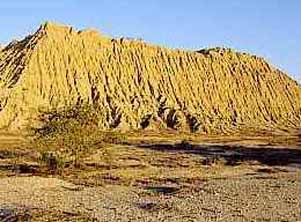
This picture of what before was a magnificent pyramid, now looks like a sad caricature, you can compare it with the previous pictures taken only with ten years of difference, but in the interval this abode pyramid was visited by the Nino only once.
|
|
|
|
|
Tucume Pyramids
Purgatorio (purgatory) is the name by which local people refer to the dozens of prehispanic pyramids, enclosures and mounds found on the plain around La Raya Mountain, south of the La Leche River. This is the site of Tucume, covering an area of over 540 acres and encompassing 26 major pyramids and platforms.
This site was a major regional center, maybe even the capital of the successive occupations of the area by the Lambayeque/Sican (1000/1100-1350 AD) CHECK CHECK, Chimú (1350-1450 AD) and Inca (1450-1532 AD). Local shaman healers (“curanderos”) invoke the power of Tucume and La Raya Mountain in their rituals, and local people fear these sites. Hardly anyone other than healers ventures out in this site at night.
The plains of Tucume are part of the Lambayeque Valley, the largest valley of the North Coast of Peru. The Lambayeque Valley boats scores natural and man-made waterways. lt is also a region of numerous pyramids.
Tucume lies on what was once the southern margin of the valley, but thanks to the Taymi irrigation canal (over 43 miles long), which brings water northward from the Chancay river, it is surrounded by fertile agricultural land. lt seems very likely that the construction of the Taymi canal coincided with the foundation of Tucume, an important center of the region throughout its 400-year history. Modern Tucume, which lies very close to the site and boasts its own prehispanic village pyramid, Huaca del Pueblo, is located 17 miles north of the city of Chiclayo.
The largest and most impressive pyramids are found in the monumental sector of the archaeological site, to the north and northeast of La Raya Mountain (“Mountain of the Ray”). Investigations carried out in conjunction with Thor Heyerdahl, the famous Norwegian seafarer and explorer, have concentrated on three major structures: Huaca Larga, Huaca 1 and The U-shaped "Temple of the Sacred Stone". Excavations in non-monumental areas have yielded many details about the functioning of the site -some prefer the term city - and about the lives of its inhabitants.
The beginnings of Tucume are to be found in a legend recorded by Father Cabello de Balboa (1586 AD). Cala, a grandson of the mythical Naymlap, founder of the Lambayeque royal dynasty, is said to have gone to Tucume to "start new fan-tilies and settlements, bringing many people him with". The founding of the settlement seems to have taken place around 1000-1100 AD, when the old regional center at Batán Grande, to the south of the Chancay river, was burnt and abandoned. Tucume quickly rose to a preeminent position within the valley.
Evidence of the Chimú conquest, around 1350 AD, as well as the later Inca occupation of the region, by 1470 AD, has been found in ceramics, burials and dedicatory offerings. In Huaca Larga, for example, archaeologists discovered the lavish burial of a prominent Inca general, possibly the Inca governor of Tucume. Some archaeologists believe that the fire that razed the central part of Huaca Larga may coincide with the beginnings of the colonial period and of the abandonment of the site.
HUACA 1
Huaca 1 (Pyramid 1) rises 98-feet high behind the new site museum, west of Huaca Las Estacas (Pyramid of the Stakes). lt is a stepped pyramid with a long, high and narrow access ramp that makes several right-angle turns up the body of the pyramid. Two plazas, one to the north and a huge, 689 by 259-feet plaza, surrounded by high walls to the south, together with several ample annexes, also correspond to this structure. One of these annexes, referred to as "The Bell-Shaped Building" stands out as a unique Andean example of outcurving, i.e. overhanging walls, somewhat reminiscent of Japanese architecture. On top of Huaca 1 there are a series of rooms situated at different levels with access ramps and stairways. These rooms probably were living quarters of the Lambayeque elite. During the Chimú period (1350-1470 AD) Huaca 1 continued in use and bird friezes were added as a form of architectural ornamentation.
HUACA LARGA
Huaca Larga, or the Long Pyramid, is the longest adobe structure known to date. lt measures around 2,300-feet in length, from the foot of La Raya Mountain to the short, straight access ramp on the north end. Its beginnings as a freestanding platform of the Lambayeque, or Sican, culture (1000/1100-1350 AD), which is referred to as the “green phase”, are obscured by substantial remodeling that took place in the subsequent “tricolor phase”.
All buildings of this period, which marks the Chimú domination of the area, were painted in red, white and black. The murals depicting flying birds in the "Temple of the Mythical Bird" stand out as fine examples of Chimú painting. Apparently, the Chimú tried to convert Huaca Larga into something resembling a Chan Chan compound. Long corridors and dividing walls partition the complex, and researchers have identified a northern, possibly public, ceremonial area and a southern area devoted to cooking and manufacturing.
The Inca presence at Huaca Larga (1470-1532 AD) is referred to as the “stone phase” due to their preference for stone as construction material. Weaving of delicate textiles, an activity the Inca often entrusted to consecrated women, was practiced at Huaca Larga during Inca times. This tradition may well go back to Chimú or even pre-Chimú times. Burials of 19 high-status, female Inca weavers included a collection of elaborate objects. This burial site, which was found under one of the Inca-built rooms, yielded high-quality, wooden implements for spinning and weaving and inlaid earspools. In a different room atop Huaca Larga, researchers discovered three male burials, one of them of a mature, robust man with insignia, suggesting he may have been the Inca governor of Tucume.
Shortly after these burials took place, all standing structures on Huaca Larga were razed and huge tires lit on top. Oral history recalls that enormous fires were lit by the Spanish colonists to convince the local population that Tucume was indeed the gate to purgatory.
THE TEMPLE OF THE SACRED STONE
The "Temple of the Sacred Stone" is a small, unpretentious, rectangular U-shaped structure to the east of Huaca Larga. lt is considered a major temple that travelers had to pass by before entering the site. The walled roadway system of this section of the Lambayeque valley leads straight to this temple and then on to Huaca Larga.
The special, revered object of this temple appears to have been a large, upright boulder in the middle of the one-room building, but whom or what it represented remains unknown. Furthermore, archaeologists found an enormous number of offerings in and around the temple. These offerings included valuable Spondylus shells (a seashell) brought from the coast of Guayaquil, slaughtered lamas and intriguing sheet-metal miniatures representing a wide range of themes and objects (flora, fauna, ornaments, musical instruments, tools, etc.). The most delicate of Inca offerings, figurines made of solid silver or carved Spondylus and adorned with elaborate textiles, silver tupu-needles and miniature feather headdresses, were found deposited in ritual fashion by the doorway of the temple. Researchers have found similar offerings, sometimes together with human sacrifices, at other major Inca shrines. For example, just a few years back a researcher exploring the top of the snow-capped Ampato Mountain in the southern Peruvian department of Arequipa found the intact mummy of an Inca girl, whom he nicknamed "Juanita".
HUACA BALSAS
Although Huaca Balsas has suffered heavily from damage inflicted by looting, its beautiful friezes, of a quality previously unknown in the Lambayeque region, are one of Tucumes most interesting features. These include the frieze known as “the Mound of the Rafts", which is located on the southwestern margin of the site in the only group of large pyramids outside the monumental sector (see above). While the "Frieze of the Rafts" depicts a mythical scene in which a bird-man and a mythical bird lead a raft, following a similar boat with a related crew, the "Frieze of the Rite" depicts a figure who may be a priest inside a roofed structure and holding a lama in one hand and a staff in the other. While their precise meaning remains unclear, archeologist Alfredo Narváez sees a revival of the earlier Moche tradition of fine-line drawing, as seen in their exquisite ceramics, transposed to a different medium. A narrative character has been attributed to the Moche ceramic drawings. Thus, the friezes of Huaca Balsas may depict scenes that form part of one or more Lambayeque myths.
Constructed entirely of mudbrick in the lower La Leche Valley, the imposing site of Túcume on Peru's arid North Coast was in use for nearly a millennium, having been built by the Lambayeque at the beginning of the tenth century, conquered by the Chimú in 1375, and subsumed into the Inca Empire in 1470, under which it flourished until the arrival of the Spanish in 1532. The site, which is spread over more than 220 hectares, boasts 26 enormous adobe pyramids, most of which were constructed in stages throughout the site's occupation. Eroded by centuries of El Niño southern oscillation events, Túcume's monuments are today a mere shadow of their creators' architectural vision, yet the archaeological remains they contain make the site one of the most important in northern Peru. The fragility of the construction, aggressive climate, and lack of economic resources, however, have resulted in a pattern of progressive deterioration of the site. The most significant losses, from heavy rains and strong winds, have been reduced building volume and damaged painted murals. The Túcume area has been slated for tourism development in Peru, however, concerns have been raised over the development of the site without proper attention to conservation. The site's listing in 2004 attracted substantial private-sector support for the site's preservation, but a long-term plan for the conservation of its fragile and eroding remains has yet to be developed.
|
|
|
|
|
n Tucume, Peru's valley of the pyramids
January 3, 2012
By Nick Rosen
A hot desert valley was once home to one of ancient Peru’s most-impressive cities.
Photo by A pyramid at Túcume (Photo: Erika Quinteros)
Related Articles
It’s amazing to think that anyone lived here, that this valley was once green. Now it is sun-blasted, scorching hot, and the only life is the circling vultures and the rainbow-colored iguanas, like something out of a desert hallucination, skittering across the rocks.
The reminders of past life rise up around me, however, eroded to look more like drip castles than the pyramids they once were. I am in Túcume, the once-grand capital of the Sican culture, Peru’s mythical Valley of the Pyramids.
I am not far from Chiclayo, and even closer to the city of Lambayeque, where the Royal Tombs of Sipán Museum serves as one of the major tourist attractions on the north coast. Here at Túcume however, there are few visitors.
It is not hard to get to the site. Combis leave regularly from Chiclayo and Lambayeque, dropping passengers in the modern village of Túcume, from which an quick mototaxi ride leads to the ruins. By car or taxi, it is about a 30 minute ride from Chiclayo.
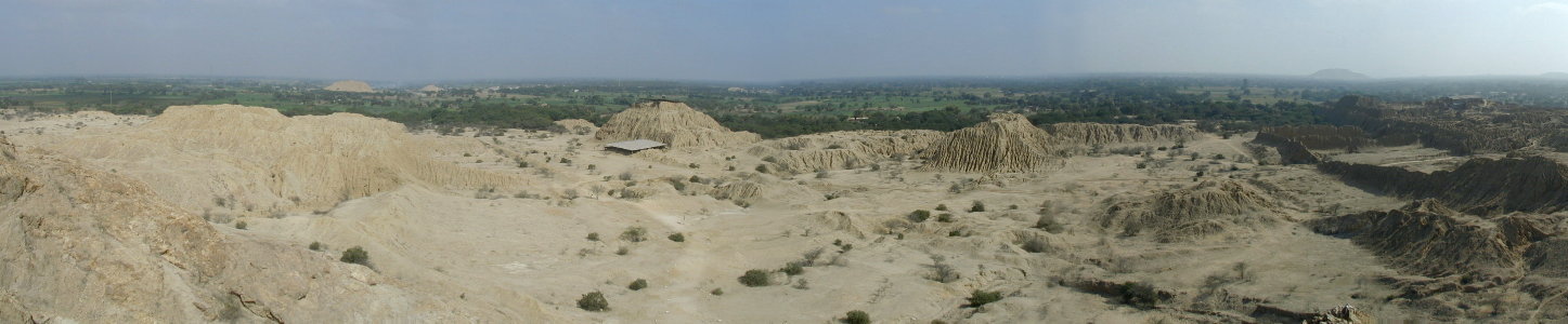
There are two main trails marked out across the desert plain in Túcume. One leads to Cerro Purgatorio, a craggy hill overlooking the 26 pyramids that comprise the site. The trail winds across the scorched valley, between several of the pyramids, before arriving at a staircase leading to different scenic overlooks on the face of Purgatorio.

The view of Huaca Larga (Photo: Heinz Plege/PromPerú)
From atop the hill, you can appreciate the scale of Túcume. Constructed about 1000 years ago, the complex features over two-dozen pyramids, in various states of erosion. It was founded after nearby Batán Grande was abandoned, and the original settler was rumored to be the grandson of Naymlap, the founder of the Sican culture and a figure you see represented all around Lambayeque. Today, the most prominent ruin at Túcume is the Huaca Larga, an elongated pyramid which extends over 2,000 feet in length.
The other trail leads across the desert to Huaca Las Balsas, a partially-excavated pyramid. Las Balsas is famous for its murals, which focus on ocean themes: waves, sea creatures and marine birds.
My favorite trail in Túcume, however, does not lead to any pyramid. Sweaty and tired from the climb up and down Purgatorio, I head to a little trail leading off from the site museum. It leads into a small, cool forest of carob trees. Birds- red, yellow, blue, gray, brown- shoot overhead and fill the forest with their songs. A bull peers in from a neighboring field. Through the trees, you can see the back side of one of Túcume’s immense pyramids.

The carob forest (Photo: Alex Bryce/PromPerú)
PRACTICALITIES
There is a hotel called Los Horcones de Túcume, just outside the archeological site. It was won several architectural awards for its traditional design. The hotel also offers lunch.
Otherwise, you are best off basing yourself in Chiclayo or Lambayeque. A visit to Túcume is easily combined with a visit to Lambayeque’s Royal Tombs Museum. A favorite lunch spot in Lambayeque is El Rincón del Pato, which specializes in duck and has many local specialties on the menu.
http://www.peruthisweek.com/travel-225-In-Tucume-Perus-valley-of-the-pyramids/ |
|
|
|
|
www.youtube.com/watch?v=8xE0f1eetKQ
11/04/2013 - Subido por Fifty Years
Valley of the Pyramids, Tucume. Fifty Years·164 videos ... Kids playing sunset Canoaby Fifty Years No views ...
Más videos de TUCUMEN PYRAMID 26 pyramids »
The city had 34 pyramids, including the Huaca de Oro (Pyramid of Gold), ... The site of Tucume, covering an area of over 540 acres and encompassing 26 major ...
Moche pyramids Tucume. ... writing and during the time the Egyptians built the Great Pyramid at Giza, people here in Caral, Peru, were building a city. ... There were originally 26 major pyramids and some smaller structures at the time.
|
|
|
|
|
|

|
|
Habemus Papam: El nuevo Papa es argentino
Jorge Bergoglio se convirtió en el sucesor de Benedicto XVI, con el nombre de Francisco I. Será el primer hispanoamericano y el primer jesuita en dirigir la Iglesia.
Asombró la sencillez con la que apareció en el balcón. "Los cardenales han ido a buscarme al fin del mundo", bromeó.
Exactamente a 15.08 (hora argentina), salió la fumata blanca por la chimenea de la Capilla Sixtina. Casi una hora después (16.04), el mundo conoció al nuevo Papa: Jorge Mario Bergoglio asomó al balcón de la basílica de San Pedro. El argentino, de 76 años, se convirtió en el primer pontífice jesuita y en el primer latinoamericano en presidir la Iglesia católica.
Los cardenales consiguieron así elegir al sucesor deBenedicto XVI, en el segundo día de cónclave tras al menos cuatro votaciones. Las campanas de San Pedro repicaron celebrando la elección, mientras miles de personas -resguardadas por paraguas bajo la lluvia romana- esperaban a que el sacerdote les hablara.
La sencillez con la que apareció en el balcón -ataviado únicamente con una túnica blanca y una cruz- contrastó con cómo se han presentado sus predecesores, y posiblemente sea toda una declaración de intenciones. También el nombre que escogió, Francisco, relacionado con los pobres (por la orden de los franciscanos), sigue esa idea.
Durante su discurso, Bergoglio les pidió a los feligreses que recen por él. "Los cardenales han ido a buscarme al fin del mundo", bromeó.
"¡Franceso, Franceso, Franceso!", le gritaba la multitud, con sus brazos en alto. "Este camino lo haremos juntos, el pueblo y el obispo.", les respondió a los creyentes, en otro momento de su discurso. "Buenas noches y que descansen", se despidió el argentino, tras las breves palabras.
En la elección anterior, Bergoglio fue el rival de Benedicto XVI. Después del cónclave de 2005, incluso, se dijo que llegó a ser el más votado, pero que renunció.
Tras un primer infructuoso intento de elegir al nuevo pontífice ayer, los purpurados se reunieron esta mañana en la Capilla Sixtina y celebraron dos votaciones, que tampoco dieron resultado, por lo que los votos fueron quemados en una sola "fumata negra". Sin embargo, por la tarde, un humo blanco salió de la chimenea apostada en el Vaticano, señal de que los 115 cardenales electores habían llegado a un acuerdo en la emblemática Capilla Sixtina.
La fumata blanca salió de la chimenea de la Capilla a las 19.08 hora local (15.08 Argentina). Los 115 cardenales han tardado poco más de 25 horas en elegir al sucesor de Benedicto XVI. La rapidez en la elección mantiene la tónica de los últimos decenios, en los que no se han superado las once votaciones. Pío XII fue elegido con tres votaciones y en apenas 24 horas; Juan Pablo I, con cuatro; Benedicto XVI con cuatro, Pablo VI, con cinco; Juan Pablo II, con ocho, y Juan XXIII, con once.
"Habemus Papam" o "Habemus Pontificem", que traducido al español significa "tenemos papa o pontífice" es una expresión latina que utiliza el cardenal protodiácono para anunciar al mundo la elección de la nueva cabeza de la Iglesia católica, y que se empleó en esta oportunidad.
Fuente: lagaceta
|
¿TUCUMAN SIGNIFICA "FIN DEL MUNDO"?
1. Mateo 28:20: enseñándoles que guarden todas las cosas que os he mandado; y he aquí yo estoy con vosotros todos los días, hasta el FIN DEL MUNDO. Amén.
Mateo 28
1. Pasado el día de reposo, al amanecer del primer día de la semana, vinieron María Magdalena y la otra María, a ver el sepulcro.
2. Y hubo un gran terremoto; porque un ángel del Señor, descendiendo del cielo y llegando, removió la piedra, y se sentó sobre ella.
3. Su aspecto era como un relámpago, y su vestido blanco como la nieve.
4. Y de miedo de él los guardas temblaron y se quedaron como muertos.
5. Mas el ángel, respondiendo, dijo a las mujeres: No temáis vosotras; porque yo sé que buscáis a Jesús, el que fue crucificado.
6. No está aquí, pues ha resucitado, como dijo. Venid, ved el lugar donde fue puesto el Señor.
7. E id pronto y decid a sus discípulos que ha resucitado de los muertos, y he aquí va delante de vosotros a Galilea; allí le veréis. He aquí, os lo he dicho.
8. Entonces ellas, saliendo del sepulcro con temor y gran gozo, fueron corriendo a dar las nuevas a sus discípulos. Y mientras iban a dar las nuevas a los discípulos,
9. he aquí, Jesús les salió al encuentro, diciendo: ¡Salve! Y ellas, acercándose, abrazaron sus pies, y le adoraron.
10. Entonces Jesús les dijo: No temáis; id, dad las nuevas a mis hermanos, para que vayan a Galilea, y allí me verán.
11. Mientras ellas iban, he aquí unos de la guardia fueron a la ciudad, y dieron aviso a los principales sacerdotes de todas las cosas que habían acontecido.
12. Y reunidos con los ancianos, y habido consejo, dieron mucho dinero a los soldados,
13. diciendo: Decid vosotros: Sus discípulos vinieron de noche, y lo hurtaron, estando nosotros dormidos.
14. Y si esto lo oyere el gobernador, nosotros le persuadiremos, y os pondremos a salvo.
15. Y ellos, tomando el dinero, hicieron como se les había instruido. Este dicho se ha divulgado entre los judíos hasta el día de hoy.
16. Pero los once discípulos se fueron a Galilea, al monte donde Jesús les había ordenado.
17. Y cuando le vieron, le adoraron; pero algunos dudaban.
18. Y Jesús se acercó y les habló diciendo: Toda potestad me es dada en el cielo y en la tierra. (Escalera de Jacob)
19. Por tanto, id, y haced discípulos a todas las naciones, bautizándolos en el nombre del Padre, y del Hijo, y del Espíritu Santo; (Simbolo de la señal de la CRUZ es una referencia a la CRUZ DEL NORTE. No hay que descartar que tambien lo sea a la CRUZ DEL SUR. Recordemos que BENJAMIN tambien significa HIJO DEL SUR. EL TROPICO DE CAPRICORNIO tiene referencia al 21/22 de diciembre.)
QUE SIGNIFICA EL NOMBRE TUCUMAN?
Según unas fuentes, el nombre de Tucumán proviene de la deformación del vocablo quechua "Yucumán", que significa "lugar donde nacen los rios". Por otro lado, se dice que el vocablo Tucumán proviene de la voz quechua "Tucma" que significa "donde terminan las cosas", indicando a esta región como el último reducto incaico, ya que estuvo poblado primitivamente por tribus de gran desarrollo cultural, quienes a su paso dejaron vestigios que aún se conservan.
20. enseñándoles que guarden todas las cosas que os he mandado; y he aquí yo estoy con vosotros todos los días, hasta el fin del mundo. Amén. ("FIN DEL MUNDO" TAMBIEN es traducido como "FIN DE LA ERA", osea al comienzo de la ERA DE ACUARIO. ¿TUCUMAN, LA CAPITAL DE LA ARGENTINA, SIGNIFICA "FIN DEL MUNDO"?) |
|
|
|
|
Virgen de la Merced
De Wikipedia, la enciclopedia libre
La Virgen de la Merced o Nuestra Señora de las Mercedes es una de las advocaciones marianas de la Bienaventurada Virgen María. Es equivalente también el nombre de Virgen de la Misericordia.
En su conmemoración se ha establecido la fiesta de la Merced o de las Mercedes, el día 24 de septiembre.
Se dice que el 1 de agosto de 1218, fiesta del santo fundador Pedro Nolasco tuvo una visita de la Santísima Virgen, dándose a conocer como La Merced, que lo exhortaba a fundar una Orden religiosa con el fin principal de redimir a aquellos cristianos cautivos. En ese momento, la península Ibérica estaba dominada por los musulmanes, y los piratas sarracenos asolaban las costas del Mediterráneo, haciendo miles de cautivos a quienes llevaban al norte de África.
Pedro Nolasco impulsó la creación de la Real y Militar Orden de la Merced, que fue fundada en la Catedral de Barcelona, con el apoyo del rey Jaime I el conquistador, en 1218.
En las primeras Constituciones de la Orden, en 1272, la Orden recibe ya el título de "Orden de la Virgen de la Merced de la Redención de los cristianos cautivos de Santa Eulalia de Barcelona".
En el año 1265 aparecieron las primeras monjas (comendadoras) de la Merced.
Se calcula que fueron alrededor de trescientos mil los redimidos por los frailes mercedarios del cautiverio de los musulmanes.
Los seguidores de la Orden de la Merced estuvieron entre los primeros misioneros de América, en la isla de La Española o República Dominicana.
La devoción a la Virgen de la Merced se difundió muy pronto por Cataluña y por toda España, por Francia y por Italia, a partir del siglo XIII con la labor de redención de estos religiosos y sus cofrades. Con la Evangelización de América, en la que la Orden de la Merced participó desde sus mismos inicios, la devoción se extendió y arraigó profundamente en todo el territorio americano.
La llegada de la orden religiosa de los mercedarios a América, un poco relacionada con el antiguo espíritu de los caballeros que fueron a las Cruzadas a Tierra Santa y juntamente con el culto de la Virgen Compasiva, coincide con el poblamiento de las principales ciudades andinas cercanas a la línea ecuatorial como son: Cuzco, Lima, Quito y la Villaviciosa de la Concepción o San Juan de Pasto no obstante que esta última tenía como patrona religiosa a la Pura y Limpia Concepción como su nombre lo indica. El Convento Mercedario primeramente se funda en Santiago de Cali hacia 1536 y en Pasto hacia 1545 y la iglesia anexa desde 1550, volviéndose muy famoso el ornato de este templo con una puerta labrada con leones dorados en su parte superior, imitando a los que fueron concedidos, junto con el título de ciudad y el sobrenombre de San Juan Bautista, a la Villa de Pasto, es conocida popularmente en San Juan de Pasto como la Michita Linda
Es en el siglo XVIII, de acuerdo al minucioso relato de José Rafael Sañudo, cuando la Virgen de las Mercedes aparece como protectora del Cabildo y pueblo de San Juan de Pasto respecto de erupciones y terremotos y otros eventos naturales dañinos, de hecho empieza a figurar la graciosa imagen como si fuera la que tiene el mando o el gobierno de Pasto. Son la fuerza de la tradición oral así sustentada y, en parte, el sincretismo o mestizaje religioso que la acompaña, los factores por los cuales se puede considerar a la Virgen de las Mercedes como Gobernadora de la Ciudad y no porque alguna autoridad civil en el siglo XX lo haya establecido por decreto. En 1612 se completó el templo de la Merced en Pasto y el trabajo en madera ocupó a los artesanos y escultores Lázaro de Vergara (las dos puertas talladas, tirantes para los alfarjes de tipo mudéjar en la nave y el presbiterio), Rodrigo de Chaves (cantería de la portada y esculturas), el batihoja y doradores Juan de Echeverri, Francisco Gallardo y Francisco Benítez más el tabernáculo de tres cuerpos realizado por Gómez de Rojas en 1660.
Perú es actualmente el país que reúne a la mayor cantidad de fieles de toda América y que cada 24 de septiembre celebran esta fiesta en honor a la Bienaventurada Virgen María.
La devoción a la Virgen de la Merced se difundió en Bolivia, en el departamento de La Paz, donde hoy se le rinde veneración, al año se le cambia 3 veces sus vestiduras, la primera vez que se le cambia es la fecha del 3 de agosto recordando la primera vez que derramó lágrimas, la segunda vez el 24 de septiembre recordando su fiesta y la tercera y última vez en Navidad como regalo a su devoción. El 24 de septiembre en la Iglesia de la Merced se celebra una eucaristía de fiesta, nueve días antes se le reza la novena y al finalizar existe una gran procesión en su honor. En Potosí, se celebra una solemne y lucida fiesta organizada por la Archicofradía de Nuestra Señora de La Merced, institución fundada en 1730 y que llegó a cobijar en el siglo XVIII a 10.000 cofrades.
La iconografía usada para representar a la Virgen de la Merced queda definida a partir del siglo XVI, consistiendo fundamentalmente en el hábito mercedario: túnica, escapulario y capa, todo en color blanco, con en el escudo mercedario en el pecho. Otros elementos recurrentes son las cadenas y el grillete, símbolos también del cautiverio. Normalmente, además del escapulario del hábito, lleva otro pequeño en la mano que ofrece a los fieles.
Suele aparecer tocada con corona de reina, y también con el cetro en la mano derecha. En muchas ocasiones sostiene en la izquierda al Niño Jesús, que también puede llevar un escapulario en las manos. Otro modelo iconográfico es el de la Virgen Comendadora, sedente en el coro, sin niño ni cetro, con las constituciones de la Orden en una mano.
|
|
|
|
|
|
hola ermano te keria eskribir, para ke tu kon tus konocimientos me pudieras decir 2 cosas una; ke signifika ke yo haya nacido el 14 de septiembre del 80 y ke signifika ke existe un libro (la historia de copiapo x carlos sayago = ayasgo?) ke te lo rekomiendo ke lo leas aun ke no es necesario todo PORKE LA INFORMACION SALE EN LAS PRIMERAS PAGINAS. kon respecto al tema de TUCMA, ke despues paso a ser llamado TUCUMAN, en los tiempos de VIRACOCHA. ahi se ase mencion al fin del mundo pero no como tucuman sino como chilli = chile ; chilli del ingles ke kiere decir aji = el aji tiene la forma de sudamerica = fin del mundo. de hecho los mismos tucumanes dieron esta informacion a viracocha, pues del otro lado de la cordillera existia un pueblo mucho mas antiguo ke ellos mismos ke desendian de los guaranies, a la altura del valle copayapu = copiapo kisas tenga un nexo kon los 33 mineros no lo se aun. pero la referencia de fin de mundo se refiere a chile = Copiapo(copa de oro). aki hay algo grande...
pd: konoces los 7, 52 avos? el mio es el 23 de julio. ayudame...
|
|
|
|
|
|
PART 4 - THE GREAT PYRAMID AND THE 30th PARALLEL
|
This circle has a different orientation than the previous diagrams and is two inches in diameter.
The horizontal axis is the Equator, FC is the 30th parallel, D is 60° North latitude and E is the North Pole.
The 30th parallel is exactly one-third of the great circle distance from the Equator to the North Pole, and it is located at exactly one-half of the height of the Northern Hemisphere.
Like the Great Pyramid, the maximum latitude of the line of ancient sites is very close to the 30th parallel.
|

|
|
|
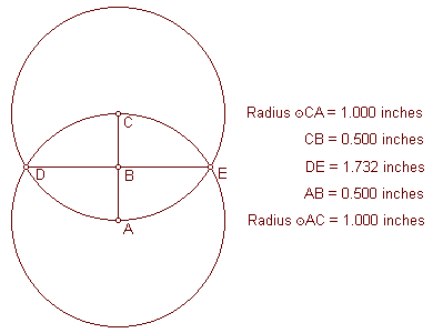
This diagram illustrates that the relationship of the 30th parallel to the circumference of the Earth is the geometric relationship known as the Vesica Pisces.
In relation to the lower circumference, DE is at 30° N latitude.
In relation to the upper circumference, DE is at 30° S latitude.
The ratio between the straight line distance of the 30th parallel and the radius of the Earth is 1.732 to one. 1.732 is the square root of three.
|
|
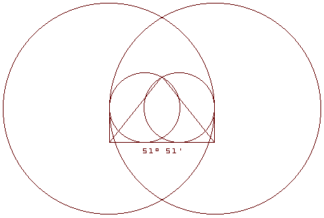
Paul Michell and Charles Henry have noted the relationship between the Great Pyramid and the Vesica Pisces.
The small circles in this diagram are one inch in diameter, and the large circles are three inches in diameter, forming a small Vesica Pisces circumscribed by a larger one.
The triangle in this diagram has the same angular dimensions as the Great Pyramid.
|
|
|
|
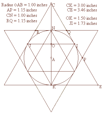
The circle in this diagram also represents the circumference of the Earth with the poles on the vertical axis.
The radius of the circle is 1.00 inch.
The exterior and interior equilateral triangles touch the circle only at the 30th parallels and the poles.
The height of each equilateral triangle is 87% of the length of each of it’s sides:
3.00 ÷ 3.46 = .87
1.50 ÷ 1.73 = .87
1.00 ÷ 1.15 = .87
The length of each of the sides of the interior triangles, including the straight line distance through the earth at the 30th parallel, is also 87% of the diameter of the Earth:
1.73 ÷ 2.00 = .87
|
The radius of the Earth is also 87% of the distance from the center of the Earth to the point of the exterior triangles’ intersections (AP, AQ, AR, etc.):
1.00 ÷ 1.15 = .87
The Greek foot is thought to have been developed before the size and shape of the Earth was known and independently from the foot, which is also thought to have been developed before the size and shape of the Earth was known. The foot is 87% of the length of the Greek foot.
The mile, which is thought to have been developed before the size and shape of the Earth was known, is 87% of the length of the nautical mile, which was developed specifically in relation to the size of the Earth. The nautical mile equals one minute of latitude, so 60 nautical miles equals one degree of latitude and 5,400 nautical miles equals the 90 degrees of latitude between the Equator and the poles.
The distance from the Equator to the poles is 6,215 miles:
5,400 ÷ 6,215 = .87
One minute of latitude equals one nautical mile at any longitude.
At the equator, one minute of longitude also equals one nautical mile, but at higher latitudes, the distances between each minute of longitude become shorter. Because the straight line distance through the Earth at the 30th parallel is 87% of the diameter of the Earth, the circumference around the Earth at the 30th parallel is 87% of the circumference of the Earth at the Equator, and each minute of longitude at the 30th parallel is 87% of the distance of each minute of longitude at the Equator. As a result, just as one nautical mile equals one minute of longitude at the Equator, one standard mile equals one minute of longitude at the 30th parallel.
The currently accepted value for the Equatorial diameter of the Earth is 7,926 miles, with an Equatorial radius of 3,963 miles. The ratio of the radius of the Earth to the straight line distance through the Earth at the 30th parallel is 1:1.732.
3,963 miles x 1.732 = 6,864 miles (the straight line distance through the Earth at the 30th parallel).
6,864 miles x pi = 21,564 miles (the circumference of the Earth at the 30th parallel).
21,564 miles ÷ 360 degrees = 59.9 miles (one degree of longitude at the 30th parallel).
59.9 miles ÷ 60 minutes = .998 miles (one minute of longitude at the 30th parallel).
As an alternative proof, the currently accepted value for the Equatorial circumference of the Earth is 24,902 miles, and the circumference of the 30th parallel is 87% of the circumference of the Earth.
24,902 miles x .87 = 21,664 miles (the circumference of the Earth at the 30th parallel).
21,664 miles ÷ 360 degrees = 60.1 miles (one degree of longitude at the 30th parallel).
60.1 miles ÷ 60 = 1.00 miles (one minute of longitude at the 30th parallel).
Conclusion: One minute of longitude equals one mile at (or, like the Great Pyramid, just below) the 30th parallel.
|
|
|
 Primeira
Anterior
28 a 42 de 57
Seguinte Primeira
Anterior
28 a 42 de 57
Seguinte Última
|
|
| |
|
|
©2026 - Gabitos - Todos os direitos reservados | |
|
|


.jpg)


