|
|
General: MISTERIO MASONICO ES EL PORQUE LA RELACION DE LOS MORMONES CON EL GRIAL
Elegir otro panel de mensajes |
|
|

Jordan River (Utah)
From Wikipedia, the free encyclopedia
The Jordan River, in the state of Utah, United States, is a river about 51 miles (82 km) long. Regulated by pumps at its headwaters at Utah Lake, it flows northward through the Salt Lake Valley and empties into the Great Salt Lake. Four of Utah's six largest cities border the river: Salt Lake City, West Valley City, West Jordan, and Sandy. More than a million people live in the Jordan Subbasin, part of the Jordan River watershed that lies within Salt Lake and Utah counties. During the Pleistocene, the area was part of Lake Bonneville.
Members of the Desert Archaic Culture were the earliest known inhabitants of the region; an archaeological site found along the river dates back 3,000 years. Mormon pioneers led by Brigham Young were the first European American settlers, arriving in July 1847 and establishing farms and settlements along the river and its tributaries. The growing population, needing water for drinking, irrigation, and industrial use in an arid climate, dug ditches and canals, built dams, and installed pumps to create a highly regulated river.
Although the Jordan was originally a cold-water fishery with 13 native species, including Bonneville cutthroat trout, it has become a warm-water fishery where the common carp is most abundant. It was heavily polluted for many years by raw sewage, agricultural runoff, and mining wastes. In the 1960s, sewage treatment removed many pollutants. In the 21st century, pollution is further limited by the Clean Water Act, and, in some cases, the Superfund program. Once the home of bighorn sheep and beaver, the contemporary river is frequented by raccoons, red foxes, and domestic pets. It is an important avian resource, as are the Great Salt Lake and Utah Lake, visited by more than 200 bird species.
Big Cottonwood, Little Cottonwood, Red Butte, Mill, Parley's, and City creeks, as well as smaller streams like Willow Creek at Draper, Utah, flow through the sub-basin. The Jordan River Parkway along the river includes natural areas, botanical gardens, golf courses, and a 40-mile (64 km) bicycle and pedestrian trail, completed in 2017.[6]
The Jordan River is Utah Lake's only outflow. It originates at the northern end of the lake between the cities of Lehi and Saratoga Springs. It then meanders north through the north end of Utah Valley for approximately 8 miles (13 km) until it passes through a gorge in the Traverse Mountains, known as the Jordan Narrows. The Utah National Guard base at Camp Williams lies on the western side of the river through much of the Jordan Narrows.[7][8] The Turner Dam, located 41.8 miles (67.3 km) from the river's mouth (or at river mile 41.8) and within the boundaries of the Jordan Narrows, is the first of two dams of the Jordan River. Turner Dam diverts the water to the right or easterly into the East Jordan Canal and to the left or westerly toward the Utah and Salt Lake Canal. Two pumping stations situated next to Turner Dam divert water to the west into the Provo Reservoir Canal, Utah Lake Distribution Canal, and Jacob-Welby Canal. The Provo Reservoir Canal runs north through Salt Lake County, Jacob-Welby runs south through Utah County. The Utah Lake Distribution Canal runs both north and south, eventually leading back into Utah Lake.[9] Outside the narrows, the river reaches the second dam, known as Joint Dam, which is 39.9 miles (64.2 km) from the river's mouth. Joint Dam diverts water to the east for the Jordan and Salt Lake City Canal and to the west for the South Jordan Canal.[10][11][12]

Map of the Salt Lake Valley
The river then flows through the middle of the Salt Lake Valley, initially moving through the city of Bluffdale and then forming the border between the cities of Riverton and Draper.[7] The river then enters the city of South Jordan where it merges with Midas Creek from the west. Upon leaving South Jordan, the river forms the border between the cities of West Jordan on the west and Sandy and Midvale on the east. From the west, Bingham Creek enters West Jordan. Dry Creek, an eastern tributary, combines with the main river in Sandy. The river then forms the border between the cities of Taylorsville and West Valley City on the west and Murray and South Salt Lake on the east. The river flows underneath Interstate 215 in Murray. Little and Big Cottonwood Creeks enter from the east in Murray, 21.7 miles (34.9 km) and 20.6 miles (33.2 km) from the mouth respectively. Mill Creek enters on the east in South Salt Lake, 17.3 miles (27.8 km) from the mouth. The river runs through the middle of Salt Lake City, where the river travels underneath Interstate 80 a mile west of downtown Salt Lake City and again underneath Interstate 215 in the northern portion of Salt Lake City. Interstate 15 parallels the river's eastern flank throughout Salt Lake County. At 16 miles (26 km) from the mouth, the river enters the Surplus Canal channel. The Jordan River physically diverts from the Surplus Canal through four gates and heads north with the Surplus Canal heading northwest. Parley's, Emigration, and Red Butte Creeks converge from the east through an underground pipe, 14.2 miles (22.9 km) from the mouth.[7] City Creek also enters via an underground pipe, 11.5 miles (18.5 km) from the river's mouth. The length of the river and the elevation of its mouth varies year to year depending on the fluctuations of the Great Salt Lake caused by weather conditions. The lake has an average elevation of 4,200 feet (1,300 m) which can deviate by 10 feet (3.0 m).[3] The Jordan River then continues for 9 to 12 miles (14 to 19 km) with Salt Lake County on the west and North Salt Lake and Davis County on the east until it empties into the Great Salt Lake.[7][8][11]
Discharge[edit]
The United States Geological Survey maintains a stream gauge in Salt Lake City that shows annual runoff from the period 1980–2003 is just over 150,000 acre-feet (190,000,000 m3) per year or 100 percent of the total 800,000 acre-feet (990,000,000 m3) of water entering the Jordan River from all sources. The Surplus Canal carries almost 60 percent of the water into the Great Salt Lake, with various irrigation canals responsible for the rest. The amount of water entering the Jordan River from Utah Lake is just over 400,000 acre-feet (490,000,000 m3) per year. Inflow from the 11 largest streams feeding the Jordan River, sewage treatment plants, and groundwater each account for approximately 15 percent of water entering the river.[13]
Watershed[edit]

Map of the entire Jordan River Basin
|
|
|
|
|
Understanding Hebrew Directions – Part IV
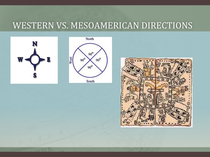
Continuing with the previous post on how we can understand Hebrew words and their meaning in order to better understand what Mormon is writing, specifically as it relates to the many directions and his usage of compass directions to describe the Land of Promise, as well as the Point of View of the writer or the subject of the writing. When trying to understand the writing of the ancients, such as Mormon, Nephi, et al., modern man simply cannot seem to come to grips with their point of view, but insists on putting his own thinking into the matter that is so out of alignment with that of the ancients.
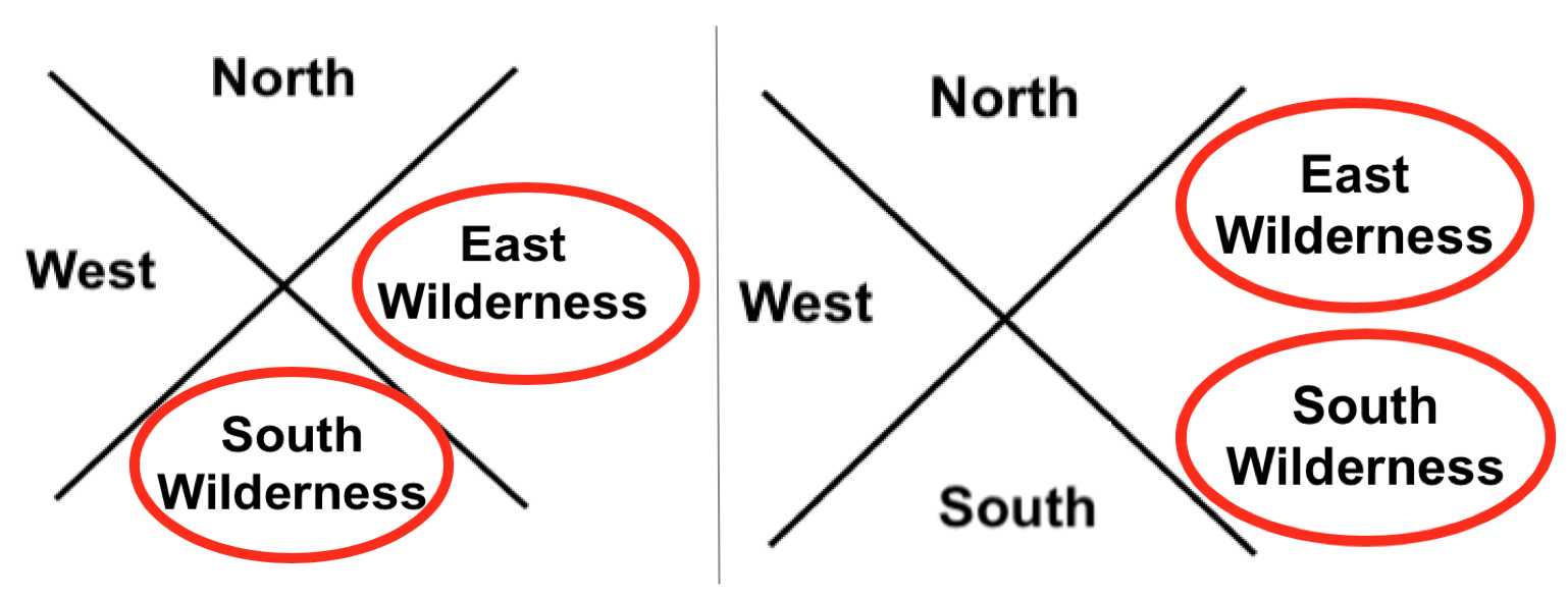
Left: The ancient Hebrews directional system contained eight compass points; Right: Our compass system today contains 32 directions. It is not just that they did not have these divisions, they did not think in terms of such minute directions
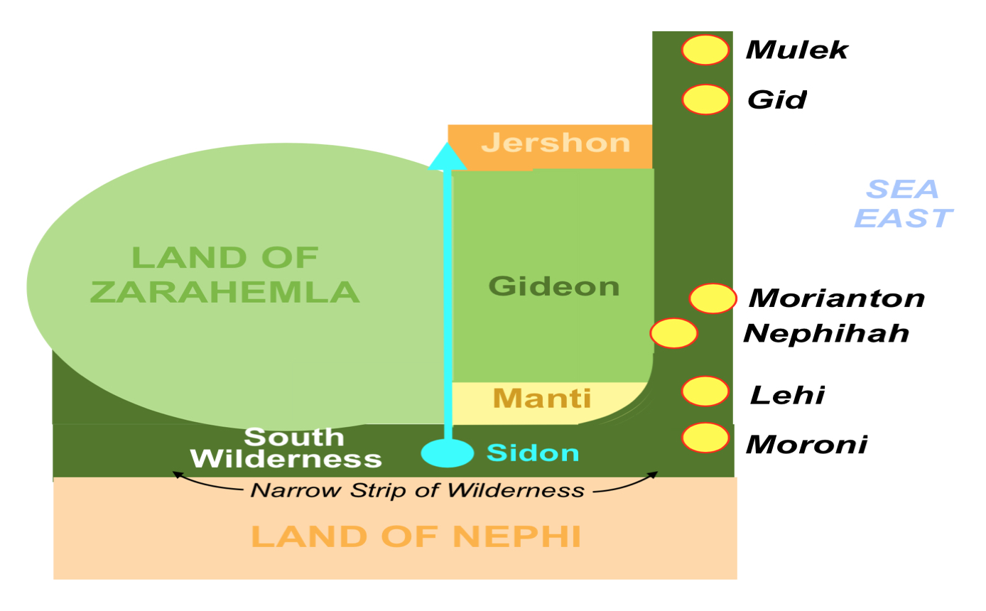
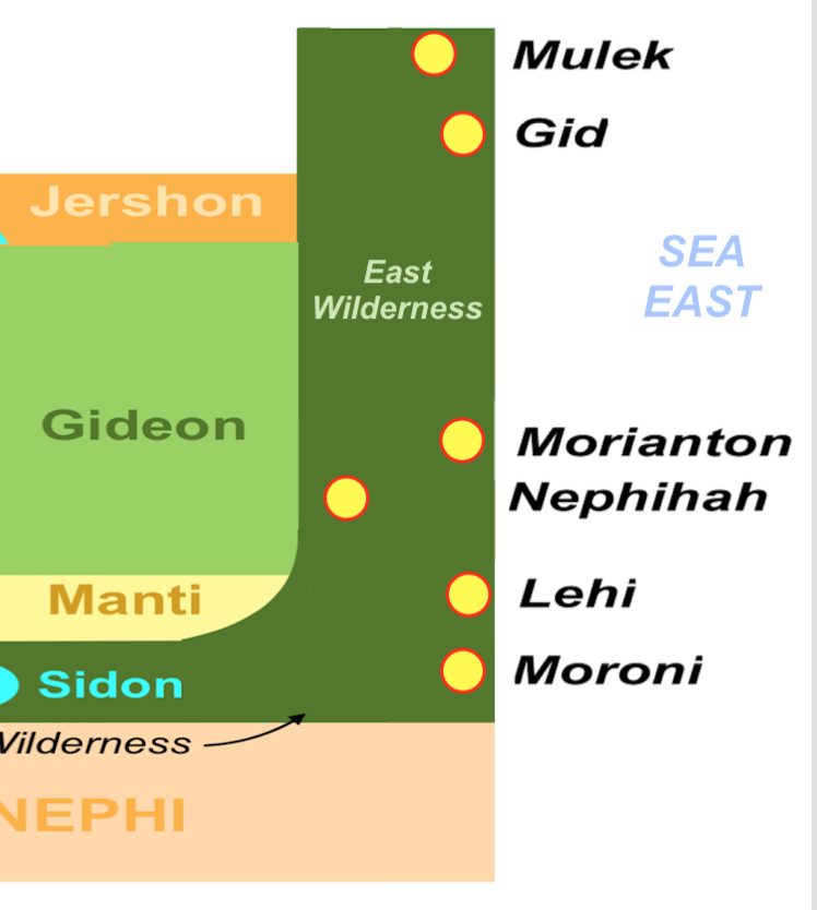
As an example, when it comes to directions, we think in far more divisions of a cardinal point than they did. Their view of their world in the sense of directions was very limited. They had limited need for anything more than the four cardinal directions, north-east-south-west, while we today use far more because we have a far greater geographical setting in our world than did the ancients. Thus, when Mormon describes an East Sea or an East Wilderness, we need to understand that it was in the east and not somewhere else. The same is true with the South Wilderness or a West Wilderness. Consequently, we need to place an East Wilderness and a South Wilderness within their proper north, east, south, and west orientation to the Point of View of the writer, which is the Land of Zarahemla.
Left: Correct usage of east and west wildernesses; Right: Incorrect. When someone places both the East and South Wilderness in the East, it is simply not something the Hebrews or Nephites would have ever done and never did do
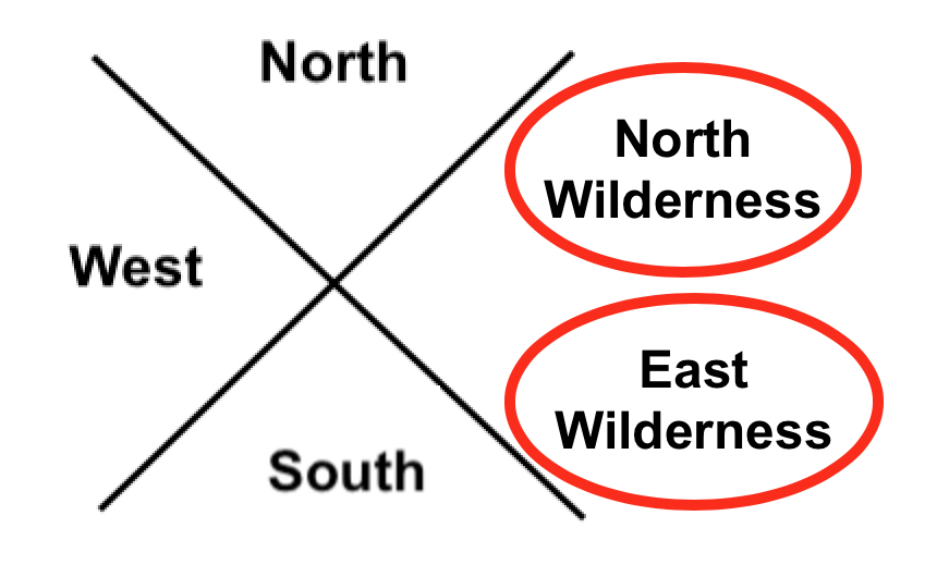
Even if we were more accurate to directions and labeled the east wilderness above as the north wilderness and the south wilderness above as the east wilderness, it would not fit Hebrew thinking.
The problem is, and always is, that the Hebrews/Jews/Nephites did not think the way we think today. First of all, they would never put a north or south anything in the east—the East was a pure direction. It was their entire being, their entire religion base, the way they drew maps, and thought of their universe. Nor would they have doubled up on two directions in a single direction, like the Mesoamericanists’ seas above or the Venice Priddis’ map. It simply would never happen—it simply is not within the Hebrew/Jewish/Nephite mindset to think that way. East of Zarahemla would be an East Wilderness, not a South Wilderness. In fact, everything to the East of Zarahemla (or even Bountiful and Nephi) would be East in Hebrew directional thinking—never anything else.
After the Lamanites were driven out of the “east wilderness” Moroni caused that the Nephites possess the land and build cities in the “east wilderness”
If a theorist places something there, then they are wrong. And if they are going to follow the overall comments of Mormon, the Nephites drove the Lamanites “out of the east wilderness” and shortly after, Mormon states: “when Moroni had driven all the Lamanites out of the east wilderness, which was north of the lands of their own possessions, he caused that the inhabitants who were in the land of Zarahemla and in the land round about should go forth into the east wilderness, even to the borders by the seashore, and possess the land” (Alma 50:9). Mormon then goes on to write: “And thus he cut off all the strongholds of the Lamanites in the east wilderness, yea, and also on the west, fortifying the line between the Nephites and the Lamanites, between the land of Zarahemla and the land of Nephi, from the west sea, running by the head of the river Sidon—the Nephites possessing all the land northward, yea, even all the land which was northward of the land Bountiful, according to their pleasure” (Alma 50:11).

http://nephicode.blogspot.com/2018/04/understanding-hebrew-directions-part-iv.html |
|
|
|
|
Cathedral of the Madeleine
© 2018 Snapping the Globe, L.L.C. All rights reserved.
The Mormans…yes, when you think of Utah and religion, you think of the Mormans.
Salt Lake City may be the headquarters of The Church of Jesus Christ of Latterday Saints (LDS), but a couple of blocks away from the infamous Temple Square, there are Catholics.
Leave it to me to find a beautiful Cathedral in Utah…The Cathedral of the Madeleine.
Lawrence Scanlan, an Irish Catholic missionary priest, took on the task of running St. Mary Magdalene church in the Utah Territory in 1873. It was the only church and Catholic institution in the territory and served approximately 800 members from the region’s mining camps. Traveling by horseback, stagecoach or rail, he made monthly visits to say mass in various areas.
After being appointed Vicar Apostolic of Utah and Titular Bishop of Lavanden by Pope Leo XIII, he received his episcopal consecration in 1887. Finally being named as the first Bishop of Salt Lake, he took to the task of initiating construction of the Cathedral in 1900.

Situated on its second site within the city, it lies only a couple of blocks from the monumental complex of the Latter Day Saints and fills the skyline with its twin towers. Before entering, make sure to take a walk around the church and try to spot all of the gargoyles!


Though I was awe-struck at the ornate interior when I entered, I learned that originally the church was not this way upon its completion. In 1909, the church was mostly unadorned with plain green walls and white columns, yet was fitted with exquisite stained glass windows from Germany. Additionally, plans for the exterior called for a plain sandstone building however, the exterior was built in the Neo-Romanesque style. Eventually, after the dedication, renovations commenced to modify the interior, resulting in a Neo-Gothic style with a Spanish influence. Colorful murals, including the Stations of the Cross, interior panels, statues of carved wood and ceiling frescoes were added along with ornate shrines.


 Over the years, many renovations have been completed, including the addition of a new altar, movement of the bishop’s chair, the addition of a separate chapel for the Blessed Sacrament and a more ample baptismal font. Though the baptismal font was dry, I was able to visit the new chapel in which the casket of the Lawrence Scanlan, was placed, as per his request. On top of the casket is a reliquary containing a small piece of Saint Mary Madeline making the Cathedral one of only two in the world to contain a first class relic of the saint that the Cathedral is named for. Over the years, many renovations have been completed, including the addition of a new altar, movement of the bishop’s chair, the addition of a separate chapel for the Blessed Sacrament and a more ample baptismal font. Though the baptismal font was dry, I was able to visit the new chapel in which the casket of the Lawrence Scanlan, was placed, as per his request. On top of the casket is a reliquary containing a small piece of Saint Mary Madeline making the Cathedral one of only two in the world to contain a first class relic of the saint that the Cathedral is named for.


 Masses are said in both English and Spanish many times a week and it is my understanding that tickets for the choral concerts are a hot commodity. The Cathedral, home to the only co-educational Catholic Choir School in the United States (established in 1996), has over 350 students from Pre-Kindergarten through Eighth Grade. Performing over 9,000 hours every year in the Cathedral as well as concert series, the choristers take part in tours throughout the world in addition, to singing regularly with local arts organizations, including the Utah Symphony and The Morman Tabernacle Choir. Masses are said in both English and Spanish many times a week and it is my understanding that tickets for the choral concerts are a hot commodity. The Cathedral, home to the only co-educational Catholic Choir School in the United States (established in 1996), has over 350 students from Pre-Kindergarten through Eighth Grade. Performing over 9,000 hours every year in the Cathedral as well as concert series, the choristers take part in tours throughout the world in addition, to singing regularly with local arts organizations, including the Utah Symphony and The Morman Tabernacle Choir.
There are many religious experiences to be had in Salt Lake City…make The Cathedral of the Madeleine one of them.
Check out Facebook, Snapping the Globe and Instagram, @snappingtheglobe for more pictures.
The Cathedral of the Madeleine
- https://www.utcotm.org/
- Address: 331 E S Temple, Salt Lake City, UT 84111
- Hours: 0700-2100, daily
- Mass Times: Monday-Friday, 0800 and 1715. Saturday, 0800, 1700 (English anticipated), 1900 (Spanish anticipated). Sunday, 0830, 1100, 1500 (Spanish), 1800
- Admission: free
- Getting There:
|
|
|
 Primer
Anterior
4 a 18 de 18
Siguiente Primer
Anterior
4 a 18 de 18
Siguiente
 Último
|
|
| |
|
|
©2024 - Gabitos - Todos los derechos reservados | |
|
|


![That's one small step..." —Neil Armstrong [1024 x 1333] : r/QuotesPorn](https://i.imgur.com/lfLGX.jpg)