|
|
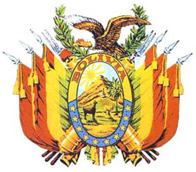
General: BOLIVIA/COLUMBIA/PALOMA DE NOE/OLIVO/LA PAZ
Choose another message board |
|
Reply |
Message 1 of 66 on the subject |
|
EL AGUILA ES EL ANIMAL QUE MIRA CON MAS PROFUNDIDAD
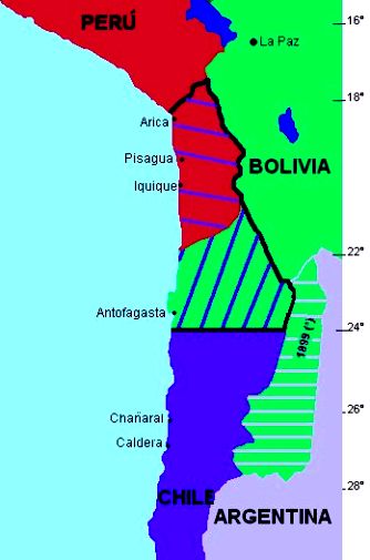
IMITEMOSLA Y MIREMOS MAS PROFUNDO QUE LA LONGITUD DE NUESTRA NARIZ CON AYUDA DE YHWH-¿CUAL ES LA VERDAD DETRAS DE LA RECUPERACION DEL MAR DE BOLIVIA?
EL OJO OMNISCIENTE EN CONTEXTO AL AGUILA
11. Proverbios 30:17: El ojo que escarnece a su padre Y menosprecia la enseñanza de la madre, Los cuervos de la cañada lo saquen, Y lo devoren los hijos del águila.
17. Jeremías 49:22: He aquí que como águila subirá y volará, y extenderá sus alas contra Bosra; y el corazón de los valientes de Edom será en aquel día como el corazón de mujer en angustias.
Recuperemos a MARIA MAGDALENA, NUESTRA MADRE
|
|
|
|
Reply |
Message 37 of 66 on the subject |
|
Los Aymaras "Hay indicios de que la cultura aymara es anterior a la egipcia y la sumeria" En los templos de la ciudad se han encontrado dibujos de animales del pleistoceno , extinguidos hacia el año 12000 A.C. Las aguas del lago albergan especies de la fauna marina, cuya presencia a 4.000 mts de latitud solo podría explicarse como consecuencia de una marejada planetaria.  Los Moais de la isla de Páscua miraban a Las Pleyades y a Orión. el astrónomo William Liller descubrió que, aunque algunas de estas estatuas de piedra estaban situadas en paralelo a la costa, sus ahus o plataformas ceremoniales no lo estaban y que otras ubicadas más al interior tampoco seguían esta norma. Y dedujo que su posición podía corresponderse con una orientación astronómica, que en un primer momento relacionó con los equinoccios y solsticios y con disposiciones solares. Nos dimos cuenta de que muchas de las orientaciones interpretadas por Liller como equinocciales en realidad se correspondían con el cinturón de Orión (Tautoru), y que la gran mayoría de las solsticiales se relacionaban con la ubicación de las Pléyades (Matariki), el asterismo más importante de la cultura Rapa Nui.  Como podrás observar las civilizaciones antiguas "misteriosamente" sabían mas de las estrellas, orbitas, alineaciones planetarias, constelaciones y equinoccios de lo que el hombre civilizado pudo saber. Aun sabiendo todo esto, el occidentalismo se impuso y la ciencia hizo creer "civilizadamente" durante mucho tiempo que la tierra era plana y que eramos el centro del universo.  Como siempre amigo, un placer..  Para mas información sobre Lugares "Sagrados" dejo el link del foro donde posteaba antes y en el que deje un resumen de la geografía mágica de la tierra: autopoiesis.crearforo.com/lugares-sagrados-geografia-magica-de-la-tierra-es1662.html |
|
|
|
LA PIRAMIDE DETRAS DE LA PUERTA EN EL CODIGO DA VINCI
CODIFICADO EL SANTO GRIAL
FIJENSE AL MINUTO CON 4 SEGUNDOS
|
|
|
|
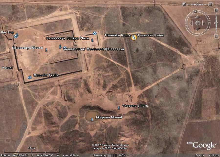
Pyramids of Akapana, Bolivia
Drainage
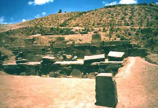
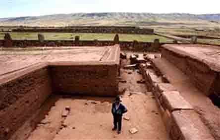
The 59-foot-tall Akapana resembles a large natural hill more than a pyramid. Closer inspection shows walls and columns sticking out from the base and carved stones on its summit and tumbling down the sides. The somewhat amorphous shape of this tremendous pyramid is the result of centuries of looting and quarrying of its stones for colonial churches and even for a railway built in the 1900s. New research shows that this pyramid was never quite finished in antiquity.
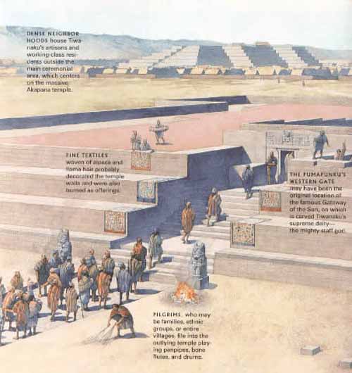
At Tiwanaku we seem to have an interesting situation where the city's previous infrastructure was razed and completely redone just before the city was suddenly abandoned. It seems that around A.D. 700, three centuries into the existence of Tiwanaku as a monumental and powerful city, there was a sudden change to direct all construction efforts toward building what was the largest structure in the Andes. The previous monuments of the city were torn down and their stones reused to build the Akapana pyramid. The effort was too great, and the pyramid lay unfinished when the city was abandoned. One Spanish chronicler said of Tiwanaku, "They build their monuments as if their intent was never to finished them."
Around the rising pyramid, the arrangement of small single homes was replaced by large square compounds--also using the scavenged remains of previous monuments--serving perhaps as ritual places for powerful families or ethnic groups. What this change represents is unknown at the present. This could represent the rise of a powerful king, a popular religious movement, or the formation of a multicultural city. Whatever the cause behind this massive transformation, it didn't last long. By A.D. 950 all monumental construction suddenly ends with stones in various stages of dressing scattered around the partially built monuments.
The Akapana Pyramid Mound
In the News ...
Bolivian pyramid makeover disappoints MSNBC - October 19, 2009
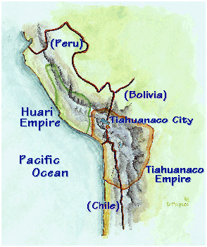
Tiwanaku, Bolivia - Eager to attract more tourists, the town of Tiwanaku in the Bolivian Andes has spruced-up the ancient Akapana pyramid with adobe instead of stone, in what some experts are calling a renovation fiasco. Now, the Akapana pyramid risks losing its designation as a U.N. World Heritage Site, and there is concern the makeover could even cause its collapse. P> The pyramid is one of the biggest pre-Columbian constructions in South America and a building of great spiritual significance for the Tiwanaku civilization, which spread throughout southwestern Bolivia and parts of neighboring Peru, Argentina and Chile from around 1500 B.C. to A.D. 1200.
Jose Luis Paz, who was appointed in June to assess damage at the site, says the state National Archeology Union, UNAR, erred in choosing to rebuild the pyramid using adobe, when it is clear to the naked eye that the original was built of stone. "They decided to go free-hand with the (new) design ... There are no studies showing that the walls really looked like this," Paz told Reuters as he stood before the pyramid in the Tiwanaku archeological site, some 40 miles north of Bolivia's administrative capital of La Paz. According to Paz, who now heads excavation at the site, the town of Tiwanaku hired the UNAR to renovate Akapana to make it "more attractive for tourists," regardless of how the pyramid may have originally looked like.
Thousands of tourists visit Tiwanaku every year and pay about $10 to enter the site, but the village of Tiwanaku, which manages the park, thought a better-looking pyramid would attract even more visitors, he said. Culture Minister Pablo Groux dismissed some of the criticism and said the renovation was long called for. "The UNAR has restored the original form the pyramid had. If we look at pictures from five years ago, there was just a hill there. What we can see now is something close to what the construction originally looked like," he told Reuters. Still, Paz said the controversy is not only about aesthetics.
The archeologist said lower decks are slightly tilted because of the extra weight of the adobe walls, which could lead to the collapse of the pyramid. The United Nations Educational, Scientific and Cultural Organization, or UNESCO, is due to visit Tiwanaku shortly and if it decides Akapana has been excessively tampered with, it may drop Tiwanaku from its list of World Heritage Sites. In 2000, UNESCO decided that Tiwanaku deserved to be in the list because its ruins "bear striking witness to the power of the empire that played a leading role in the development of the Andean pre-Hispanic civilization."
The Tiwanaku civilization, which flourished around Lake Titicaca, was one of the precursors of the Inca empire, the largest pre-Columbian civilization in the Americas. Groux believes that Tiwanaku will not lose its World Heritage status because the government halted the reconstruction project earlier this year, as soon as UNESCO told them to. "The inclusion in the list of World Heritage Sites involves regular checks, because some places may lose the essence of why they were included in the list. In the case of Tiwanaku losing that title is unlikely," he said.
Looting of Akapana's carved stones and ceramics started soon after the Spanish conquest and the structure was later used as a quarry, from which stones were extracted to build a rail line and a Catholic church near-by. Its size and the still-standing lower decks suggest that Akapana was once a remarkable building, but as a result of the ransacking and the extreme temperatures and strong winds in the Andean plateau, some 12,500 feet above sea level, the pyramid looks rundown.
Treasures found inside Bolivian Pyramid MSNBC - May 2, 2007
Archaeologists have uncovered the 1,300-year-old skeleton of a ruler or priest of the ancient Tiwanaku civilization, together with precious jewels inside a much-looted pyramid in western Bolivia. The bones are in very good condition and belong to either a ruler or a priest, Roger Angel Cossio, the Bolivian archaeologist who made the discovery, told Reuters on Wednesday. He said the tomb containing a diadem and a fist-sized carved pendant of solid gold survived centuries of looting by Spanish invaders and unscrupulous raiders who depleted Tiwanaku of many precious treasures.
"After so much looting ... miraculously this has stayed to tell us the history," Cossio said. "It¹s a complete body... next to it are jewels, offerings and a llama." The llama may have been a status symbol or a source of food for the journey to the afterlife, archaeologists said. The corpse was found in a niche carved inside the 15-yard-high (15-meter-high) Akapana pyramid, which was built around 1200 B.C. and is described by experts as one of the biggest pre-Columbian constructions in South America. At its peak, the city of Tiwanaku stretched over 1,480 acres (600 hectares) and had a population of more than 100,000, according to chief archaeologist Javier Escalante, who presented the findings on Wednesday at a news conference near the pyramid.
The Tiwanaku civilization spread throughout southwestern Bolivia and parts of neighboring Peru, Argentina and Chile from around 1500 B.C. to A.D. 1200. Although experts still have to do carbon dating to determine the age of the remains, archaeologists estimate they were buried 1,300 years ago, during the decline of the Tiwanaku empire. Cossio believes the remains belong to someone of importance in the Tiwanaku society. "Not just anyone would be buried under the Akapana pyramid," he said. In the 1900s, workers used the base of the pyramid as a quarry from which they extracted stones to build a rail line connecting the neighboring town of Guaqui with La Paz.
INCA CIVILIZATION
ShareThis
PYRAMID INDEX
SACRED PLACES AND TEACHINGS INDEX
ANCIENT CIVILIZATIONS INDEX
ALPHABETICAL INDEX OF ALL FILES
CRYSTALINKS HOME PAGE
PSYCHIC READING WITH ELLIE
2012 THE ALCHEMY OF TIME
|
|
|
|
|
|
Reply |
Message 38 of 66 on the subject |
|
|
Tiwanaku
In the holograms of reality, Tiwanaku is another ancient civilization whose timeline came and went, leaving behind megalithic monuments that go without explanation as to their mathematical design and construction. Considered by some the oldest city in the world, much of Tiwanaku's creation defies the laws of physics and mathematics even by today's standards. Many monuments bear close resemblance to those created by other ancient cultures all over the planet, truly an overlap if one were to place hologram over hologram, to define the journey of humanity in time.
As with many other sacred sites throughout the planet Tiwanaku remains an enigma allowing researchers to speculate on its origins and purpose then parallel that with other ancient civilizations left behind by unknown beings surviving in time with great stone markers which bear clues to humanity's creation story. Gods, temples, idols, metaphors, all clues in a puzzle humanity is unraveling at this time of conscious awakening.
Background - Back Story
Tiwanaku is an important Pre-Columbian archaeological site in western Bolivia. It is recognized by Andean scholars as one of the most important precursors to the Inca Empire, flourishing as the ritual and administrative capital of a major state power for approximately five hundred years. The ruins of the ancient city state are near the south-eastern shore of Lake Titicaca in the La Paz Department, Ingavi Province, Tiwanaku Municipality, about 72 km (44 miles) west of La Paz.
The site was first recorded in written history by Spanish conquistador and self-acclaimed 'first chronicler of the Indies' Pedro Cieza de Leon. Leon stumbled upon the remains of Tiwanaku in 1549 while searching for the Inca capital Collasuyu. Some have hypothesized that Tiwanaku's modern name is related to the Aymara term taypiqala, meaning "stone in the center", alluding to the belief that it lay at the center of the world. However, the name by which Tiwanaku was known to its inhabitants has been lost, as the people of Tiwanaku had no written language.
Some believe Tiwanaku is the oldest city in the world. Others believe it was built by an extraterrestrial race who also created the Nazca Lines.
Cultural Development and Agriculture
The area around Tiwanaku may have been inhabited as early as 1500 BC as a small agriculturally-based village. Most research, though, is based around the Tiwanaku IV and V periods between AD 300 and AD 1000, during which Tiwanaku grew significantly in power. During the time period between 300 BC and AD 300 Tiwanaku is thought to have been a moral and cosmological center to which many people made pilgrimages. The ideas of cosmological prestige are the precursors to Tiwanaku's powerful empire.
TiwanakuÕs location between the lake and dry highlands provided key resources of fish, wild birds, plants, and herding grounds for camelidae, particularly llamas. The Titicaca Basin is the most productive environment in the area with predictable and abundant rainfall, which the Tiwanaku culture learned to harness and use in their farming. As one goes further east, the Altiplano is an area of very dry arid land.
The high altitude Titicaca Basin required the development of a distinctive farming technique known as "flooded-raised field" agriculture (suka kollus). They comprised a significant percentage of the agriculture in the region, along with irrigated fields, pasture, terraced fields and qochas (artificial ponds) farming.
Artificially raised planting mounds are separated by shallow canals filled with water. The canals supply moisture for growing crops, but they also absorb heat from solar radiation during the day. This heat is gradually emitted during the bitterly cold nights that often produce frost, endemic to the region, providing thermal insulation.
Traces of landscape management were also found in the Llanos de Moxos region (Amazonian food plains of the Moxos).
Over time, the canals also were used to farm edible fish, and the resulting canal sludge was dredged for fertilizer. The fields grew to cover nearly the entire surface of the lake and although they were not uniform in size or shape, all had the same primary function.
Though labor-intensive, suka kollus produce impressive yields. While traditional agriculture in the region typically yields 2.4 metric tons of potatoes per hectare, and modern agriculture (with artificial fertilizers and pesticides) yields about 14.5 metric tons per hectare, suka kollu agriculture yields an average of 21 tons per hectare.
Significantly, the experimental fields recreated in the 1980s by University of Chicago's Alan Kolata and Oswaldo Rivera suffered only a 10% decrease in production following a 1988 freeze that killed 70-90% of the rest of the region's production. This kind of protection against killing frosts in an agrarian civilization is an invaluable asset. For these reasons, the importance of suka kollus cannot be overstated.
As the population grew occupational niches were created where each member of the society knew how to do their job and relied on the elites of the empire to provide all of the commoners with all the resources that would fulfill their needs.
Little is known of the 30,000 to 60,000 urban dwellers or of the city's crafts or administrative functions. We also know little about the storage system that was required for the bounty of surplus foods from the agricultural fields, the vast llama herds on the Poona, and the abundant fish caught in the lake. The core of this imperial capital was surrounded by a moat that restricted access to the temples and areas frequented by royalty.
Some occupations include agriculturists, herders, pastoralists, etc. Along with this separation of occupations, there was also a hierarchal stratification within the empire.
The elite of Tiwanaku lived inside four walls that were surrounded by a moat. This moat, some believe, was to create the image of a sacred island. Inside the walls there were many images of human origin that only the elites were privileged to, despite the fact that images represent the beginning of all humans not only the elite. Commoners may have only ever entered this structure for ceremonial purposes since it was home to the holiest of shrines.
Rise and Fall of Tiwanaku
The city and its inhabitants left no written history, and modern local people know little about the city and its activities. An archaeologically based theory asserts that around AD 400, Tiwanaku went from being a locally dominant force to a predatory state. Tiwanaku expanded its reaches into the Yungas and brought its culture and way of life to many other cultures in Peru, Bolivia, and Chile. However, Tiwanaku was not exclusively a violent culture. In order to expand its reach, Tiwanaku used politics to create colonies, negotiate trade agreements (which made the other cultures rather dependent), and establish state cults.
Many others were drawn into the Tiwanaku empire due to religious beliefs as Tiwanaku never ceased being a religious center. Force was rarely necessary for the empire to expand, but on the northern end of the Basin resistance was present. There is evidence that bases of some statues were taken from other cultures and carried all the way back to the capital city of Tiwanaku where the stones were placed in a subordinate position to the Gods of the Tiwanaku in order to display the power Tiwanaku held over many.
Among the times that Tiwanaku expressed violence were dedications made on top of building known as the Akipana. Here people were disemboweled and torn apart shortly after death and laid out for all to see. It is speculated that this ritual was a form of dedication to the gods. Research showed that one man who was dedicated was not a native to the Titicaca Basin, leaving room to think that dedications were most likely not of people originally within the society.
The community grew to urban proportions between AD 600 and AD 800, becoming an important regional power in the southern Andes. According to early estimates, at its maximum extent, the city covered approximately 6.5 square kilometers, and had between 15,000 - 30,000 inhabitants.
However, satellite imaging was used recently to map the extent of fossilized suka kollus across the three primary valleys of Tiwanaku, arriving at population-carrying capacity estimates of anywhere between 285,000 and 1,482,000 people.
The empire continued to grow, absorbing cultures rather than eradicating them. William H. Isbell states that "Tiahuanaco underwent a dramatic transformation between AD 600 and 700 that established new monumental standards for civic architecture and greatly increased the resident population."
Archaeologists note a dramatic adoption of Tiwanaku ceramics in the cultures who became part of the Tiwanaku empire. Tiwanaku gained its power through the trade it implemented between all of the cities within its empire.
The elites gained their status by control of the surplus of food obtained from all regions and redistributed among all the people. Control of llama herds became very significant to Tiwanaku, as they were essential for carrying goods back and forth between the center and the periphery. The animals may also have symbolized the distance between the commoners and the elites.
The elites' power continued to grow along with the surplus of resources until about AD 950. At this time a dramatic shift in climate occurred. A significant drop in precipitation occurred in the Titicaca Basin, with some archaeologists venturing to suggest a great drought. As the rain became less and less many of the cities furthest away from Lake Titicaca began to produce fewer crops to give to the elites.
As the surplus of food dropped, the elites power began to fall. Due to the resiliency of the raised fields, the capital city became the last place of production, but in the end even the intelligent design of the fields was no match for the weather. Tiwanaku disappeared around AD 1000 because food production, the empire's source of power and authority, dried up. The land was not inhabited again for many years. In isolated places, some remnants of the Tiwanaku people, like the Uros, may have survived until today.
Beyond the northern frontier of the Tiwanaku state a new power started to emerge in the beginning of the 13th century, the Inca Empire.
In 1445 Pachacuti Inca Yupanqui (the ninth Inca) began conquest of the Titicaca regions. He incorporated and developed what was left from the Tiwanaku patterns of culture, and the Inca officials were superimposed upon the existing local officials. Quechua was made the official language and sun worship the official religion. So, the last traces of the Tiwanaku civilization were integrated or deleted.
|
|
|
Architecture
[Go to 53:27]
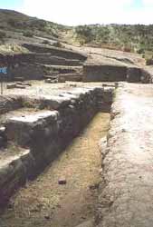
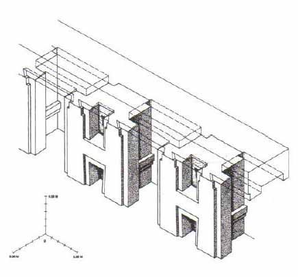
Tiwanaku monumental architecture is characterized by large stones of exceptional workmanship. In contrast to the masonry style of the later Inca, Tiwanaku stone architecture usually employs rectangular ashlar blocks laid in regular courses, and monumental structures were frequently fitted with elaborate drainage systems. The drainage systems of the Akapana and Pumapunku include conduits composed of red sandstone blocks held together by ternary (copper/arsenic/nickel) bronze architectural cramps. The I-shaped architectural cramps of the Akapana were created by cold hammering of ingots. In contrast, the cramps of the Akapana were created by pouring molten metal into I-shaped sockets.
The blocks have flat faces that do not need to be fitted upon placement because the grooves make it possible for the blocks to be shifted by ropes into place.
The main architectural appeal of the site comes from the carved images on the blocks along with carved doorways and giant stone monoliths. The stone used to build Tiwanaku was quarried and then transported 40 km or more to the city.
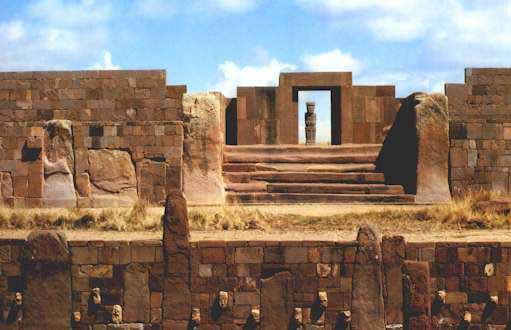
The most important edifice for dating purposes is the Kalasasaya ("Place of the Vertical Stones"). It is built like a stockade with 12 foot high columns jutting upward at intervals, each of these being carved into human figures.
The steps of the Kalasasaya (Temple), are each a
rectangular block of stone about 30 feet wide.
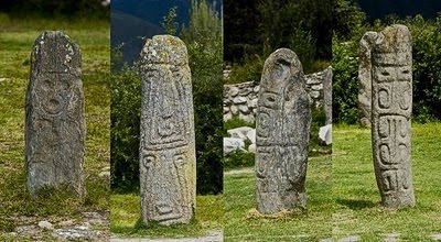
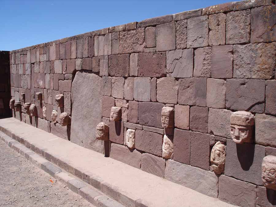
The megalithic entrance to the Kalasaya mound is here seen from the Sunken Courtyard viewing west. The Kalasaya stairway is a well-worn megalith, a single block of carved sandstone. Like the Kalasaya mound, the Sunken Courtyard is walled by standing stones and masonry infill. In this case the stones are smaller and sculptured heads are inset in the walls. Several stelae are placed in the center of the 30 m square courtyard.
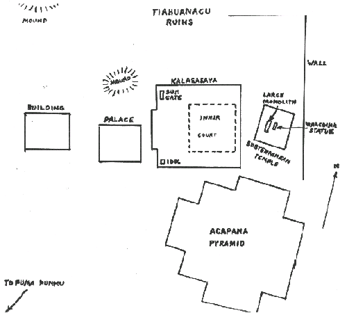
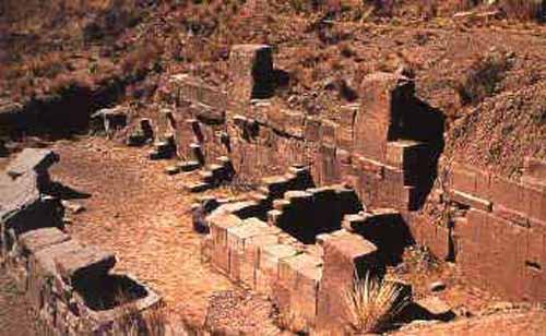
The largest terraced step pyramid of the city, the Akapana, was once believed to be a modified hill, and has proven to be a massive human construction with a base 656 feet square and a height of 55.8 feet. It is aligned perfectly with the cardinal directions. Its base is formed of beautifully cut and joined facing stone blocks. Within the cut- stone retaining walls are six T- shaped terraces with vertical stone pillars, an architectural technique that is also used in most of the other Tiwanaku monuments. It originally had a covering of smooth Andesite stone, but 90% of that has disappeared due to weathering. The ruinous state of the pyramid is due to its being used as a stone quarry for later buildings at La Paz. Its interior is honeycombed with shafts in a complicated grid pattern, which incorporates a system of weirs used to direct water from a tank on top, going through a series of levels,and finally ending up in a stone canal surrounding the pyramid. On the summit of the Akapana there was a sunken court with an area 164 feet square serviced by a subterranean drainage system that remains unexplained.
Associated with the Akapana are four temples: the Semi-subterranean, the Kalasasaya, the Putuni, and the Kheri Kala. The first of these, the Semi-subterranean Temple, was studded with sculptured stone heads set into cut-stone facing walls and in the middle of the court was located a now-famous monolithic stela. Named for archaeologist Wendell C. Bennett who conducted the first archaeological research at Tiwanaku in the 1930's, the Bennett Stela represents a human figure wearing elaborate clothes and a crown. The ancient Tiwanaku heartland is estimated to have been about 365,000, of whom 115,000 lived in the capital and satellite cities, with the remaining 250,000 engaged in farming, herding, and fishing.
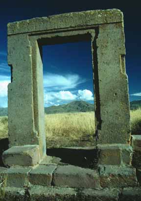
This megatlithic doorway is all that remains of the walls of a building on a small mound near the Kalasaya. Much of the readily accessible masonry at the ruin was used to construct the Catholic church in the village. A nearby railroad bridge also has Tiwanaku stone.
Adjacent to the sunken court, residences of the elite were revealed, while under the patio the remains of a number of seated individuals, believed to have been priests, faced a man with a ceramic vessel that displayed a puma-an animal sacred to the Tiwanaku. Ritual offerings of llamas and ceramics, as well as high-status goods made of copper, silver and obsidian were also encountered in this elite residential area. The cut-stone building foundations supported walls of adobe brick, which have been eroded away by the yearly torrential rains over the centuries.
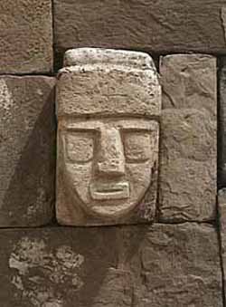
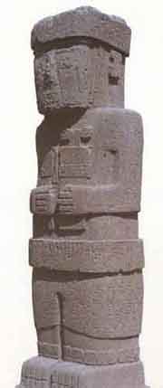
In 1934 the Peruvianist Wendell C. Bennett carried out several excavations at Tiwanaku. Excavating in the Subterranean Temple he found two large stone images. One was a bearded statue. Depicted are large round eyes, a straight narrow nose and oval mouth. Rays of lightning are carved on the forehead. Strange animals are carved up around the head. It stands over 7 feet tall with arms crossed over an ankle- length tunic, which is decorated with pumas around the hem. Serpents ascend the figure on each side, reminding one of the Feathered Serpent culture-hero known as Quetzalcoatl in Central America.
Beside the bearded statue was a much larger statue Bennett's report as "the large monolithic statue" and is over 24 feet tall. It was sculpted out of red sandstone, and is covered with carved images of various kinds. He holds objects in each hand which are totally unidentifiable, although numerous interpretations have been suggested. The lower half of its body, which is covered with fish-scales (which upon close inspection are actually fish-heads). Immediately one recalls the Mesopotamian deity called Oannes, the man-fish amphibious being who conveyed special knowledge to ancient mankind. The statue has been removed from the site and now stands in a plaza in La Paz.
This monolithic piece of work has a number of designs scattered over its surface, many of which resemble the running winged-figures found on the Gate of the Sun, only with curled-up tails. The "Weeping God" is depicted on the sides of the head of the statue.
There are numerous other statues which have been found at Tiahuanacu, several of which have found their way into various museums. Most have the incomprehensible stiff designs scattered about on their surfaces in the typical Tiahuanacu style. Some are rather large, and others are small. Depictions of toxodons and several other extinct creatures are plentiful at Tiahuanacu. The images of these extinct animals are understandable on pottery and textiles, they could be copied by anyone from the stone monuments dotting the area.
In the northwest corner stands the Gateway of the Sun,
and in the southwest corner is The Idol.
This is one of two large anthropomorphic figures standings in the southwest corner of the Kalasasaya Temple. This one faces the entrance and is placed on the central axis. With the exception of the Sun Gate, it is the most picturesque of the sculptures at Tiahuanacu, since its 7-foot height is almost covered with hieroglyphic-like carvings. No one knows if these carvings represent a form of writing or are merely decorative. The figures resemble those on Easter Island.
The Akapana is the biggest platform on the site measuring 200 meters on each side and 17 meters tall and the largest ashlars of andesite or sandstone weigh over 100 tons.
Originally, the Akapana was thought to have been made from a modified hill, but recent studies have shown that most of the hill is man-made by taking dirt from the moat and packing it behind stone walls.
It is constructed from a mix of tall, upright, and small stones. There are staircases present on the east and west sides with a sunken court 50 meters long between them. Today the area where this would be is an indiscernible hole. The structure was possibly for the shaman-puma relationship or transformation. Tenon puma and human heads stud the upper terraces.
The Akapana East was built on the eastern side of early Tiwanaku and later became a boundary for the ceremonial center and the urban area. It was made of a thick prepared floor of sand and clay and supported a group of buildings. Yellow and red clay were used in different areas for what seems like aesthetic purposes. One major observation was that it was swept clean of all domestic refuse, signaling great importance to the culture.
The Kalasasaya is a large courtyard over three hundred feet long, outlined by a high gateway. It is located to the north of the Akapana and west of the Semi-Subterranean Temple. Within the courtyard is where explorers found the Gateway of the Sun, but it is contested today that this was not its original location.
|
|
|
|
|
|
Reply |
Message 39 of 66 on the subject |
|
Near the courtyard is the Semi-Subterranean Temple; a square sunken courtyard thatÕs unique for its north-south rather than east-west axis. The walls are covered with tenon heads of many different styles postulating that it was probably reused for different purposes over time. It was built with walls of sandstone pillars and smaller blocks of Ashlar masonry. There are many more colossal stone statues, gateways and blocks including one that is 7.5 meters tall weighing well over 10 tons.
Within many of the sites structures are impressive gateways; the ones of monumental scale being placed on artificial mounds, platforms, or sunken courts. Many gateways show iconography of "Staffed Gods" that also spreads to some oversized vessels, indicating an importance to the culture. This iconography is most present on the The Gateway of the Sun.
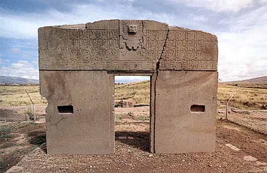
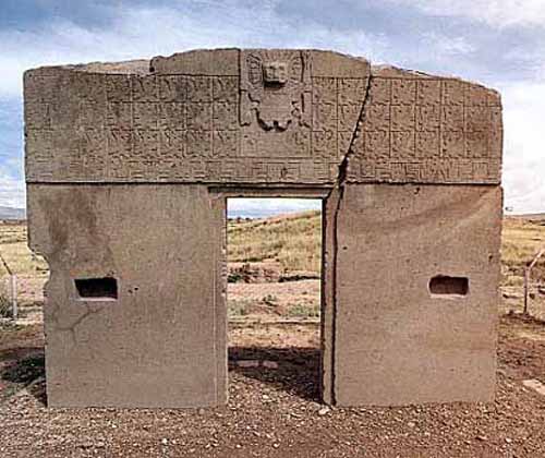
The Gate of the Sun
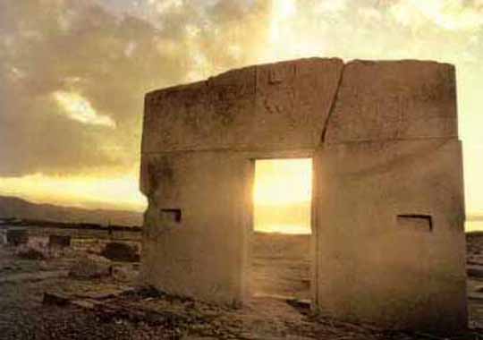
Winter Solstice
The Gate of the Sun is a stone gateway constructed by the Tiwanaku culture. It is located near Lake Titicaca at about 3,825 m above sea level in La Paz, Bolivia. The gate is approximately 9.8 ft (3.0 m) tall and 13 ft (4.0 m) wide. It was originally constructed by a single piece of stone. The weight is estimated to be 10 tons.
When the gate was originally found, it was lying face down and had a large crack. It stands in the place where it was found, although it is believed that this was not its original location. Gate of the Sun is a valuable monument to the history of art. Some elements of their iconography spread throughout Peru and parts of Bolivia; the engravings that decorate the gate has some astronomic connotations. There have been innumerable interpretations of the inscriptions on Gate of the Sun; many of them believe that it was used as a calendar.
The lintel is carved with 48 winged effigies each in a square, 32 with human faces, and 16 with condor's heads. surrounding a central figure. There are 32 effigies with human faces and 16 with condor's heads. All looked to the central figure, whose identity is still an enigma. It is a figure of a man with the head surrounded by 24 stripes that represent rays shooting from his face. The styled staffs held by the figure symbolize thunder and lightning. Some historians believe that the central figure represents the Sun God by the rays of his head, while others identified it with the Inca god Viracocha.
This huge monument is hewn from a single block of stone, and some believe that the strange symbols might represent a calendar, the oldest in the world. A huge monolithic figure, facing east in the direction of sunrise, stands as silent witness to an unknown civilization established around 2200 years ago.
The Gateway of the Sun and others located at Pumapunku are all not complete, missing part of a typical recessed frame known as a chambranle and having sockets for clamps present for additions. These architectural examples, as well as the recently discovered Akapana Gate have a unique detail and skill in stone-cutting that reveal a knowledge of descriptive geometry. The regularity of elements suggest be part of a system of proportions.
Many theories for Tiwanaku's architecture construction have been proposed. One is that they used a lukÕa which is a standard measurement of about sixty centimeters. Another argument is for the Pythagorean Ratio. This idea calls for right triangles at a ration of five to four to three used in the gateways to measure all parts. Lastly Protzen and Nair argue that Tiwanaku had a system set for individual elements dependent on context and composition. This is shown in the construction of similar gateways ranging from diminutive to monumental size proving that scaling factors did not affect proportion. With each added element, the individual pieces shifted to fit together.
Throughout their imperial reign, the Tiwanaku shared domination of the Middle Horizon with the Wari. Their culture rose and fell around the same time and was centered 500 miles north in the southern highlands of Peru. The relationship between the two empires is unknown either being cooperative or antagonistic. Definite interaction between the two is proved by their shared iconography in art. Significant elements of both of these styles, the split eye, trophy heads, and staff-bearing profile figures, for example, seem to have been derived from that of the earlier Pukara culture in the northern Titicaca Basin.
The Tiwanaku created a powerful ideology, using previous Andean icons that spread throughout their sphere of influence using extensive trade routes and shamanistic art. Tiwanaku art consisted of legible, outlined figures depicted in curvilinear style with a naturalistic manner, while Wari art used the same symbols in a more abstract, rectilinear style with a militaristic manner.
Art
Tiwanaku sculpture is comprised typically of blocky column-like figures with huge, flat square eyes, and detailed with shallow relief carving. They are often holding ritual objects like the Ponce Stela or the Bennett Monolith. Some have been found holding severed heads such as the figure on the Akapana, possibly a puma-shaman. These images suggest ritual human beheading, which correlate with the discovery of headless skeletons found under the Akapana.
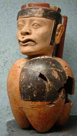
Ceramics and textiles were also present in their art, composed of bright colors and stepped patterns. An important ceramic artifact is the kero, a drinking cup, that was ritually smashed after ceremonies and placed in burials. However, as the empire expanded, ceramics changed in the society.
The earliest ceramics were "coarsely polished, deeply incised brownware and a burnished polychrome incised ware". Later the Qeya style became popular during the Tiwanaku III phase "Typified by vessels of a soft, light brown ceramic paste". These ceramics included libation bowls and bulbous bottom vases.
Examples of textiles are tapestries and tunics. The objects typically depicted herders, effigies, trophy heads, sacrificial victims, and felines. The key to spreading religion and influence from the main site to the satellite centers was through small portable objects that held ritual religious meaning. They were created in wood, engraved bone, and cloth and depicted puma and jaguar effigies, incense burners, carved wooden hallucinogenic snuff tablets, and human portrait vessels. Like the Moche, Tiwanaku portraits had individual characteristics in them.
Pumapunku
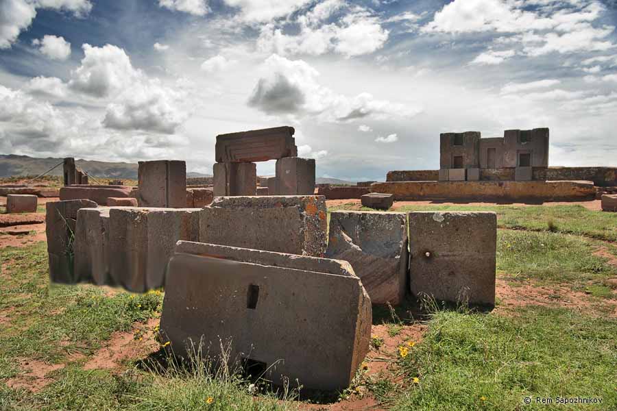
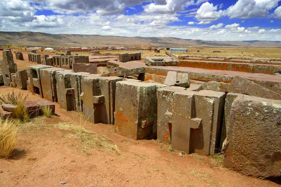
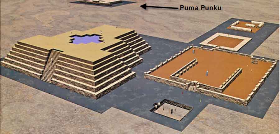
Pumapunku is a large temple complex located in Tiwanaku, Bolivia. In Aymara, the name Puma Punku means, "The Door of the Cougar". It is situated near the south eastern shore of Lake Titicaca, and sits on a plateau in the Andes at roughly 12,600 feet elevation.
Pumapunku's construction is generally argued to have taken place beginning around 200 BC. The temple itself stood at least 56 feet tall and took up an area of 164 square feet while the overall site and the surrounding constructions, namely the pyramid which the ruins sit on, extend over half a kilometer in length.
At its peak, Pumapunku is thought to have been unimaginably wondrous, adorned with polished metal plaques, brightly colored ceramic and fabric ornamentation, and trafficked by costumed citizens, elaborately dressed priests and elites decked in exotic jewelry.
Understanding of this complex is limited due to its age, the lack of a written record, and the current deteriorated state of the structures due to looting, stone mining for building stone and railroad ballast and natural weathering. The technological innovation and the beautiful stonework that went into the creation of Pumapunku have drawn comparisons to the Egyptian pyramids, Stonehenge and Easter Island.
Determining the age of these ruins has been a focus of researchers since the site's discovery. Currently archaeologists date the beginning of the Tiwanaku culture to some time around 1500 BC, and the construction of the Pumapunku complex to around 200 BC.
Previously, in the early 1900s, Bolivian engineer Arthur Posnansky, based on astronomical alignments, concluded that Tiwanaku was constructed as early as 15,000 BC (17,000 BP), possibly even older and was not an original construction of the Tiwanaku.
In the 1930s, German astronomers from the University of Bonn; Rolf Muller, Hanns Lundendorff, Friederich Becker, and Arnold Kohlshutter came to conclusions similar to Posnansky's estimate. However, as noted by Kolata subsequent archaeological research has found a complete lack of any physical evidence, including prehistoric tools and dated midden deposits, for any occupation of the Tiwanaku site as old as argued by Posnansky and the German astronomers either at the Tiwanaku Site, near it, or in direct association with the Pumapunku complex despite decades of intensive excavation and research.
The processes and technologies involved in the creation of these temples are still not fully understood by modern scholars. Our current ideas of the Tiwanaku culture hold that they had no writing system and also that the invention of the wheel was most likely unknown to them.
The architectural achievements seen at Pumapunku are striking in light of the presumed level of technological capability available during its construction. Due to the monumental proportions of the stones, the method by which they were transported to Pumapunku has been a topic of interest since the temple's discovery.
The stones are argued to have been transported up a steep incline from a quarry near Lake Titicaca roughly 20 miles away. Some of the blocks are said to weigh in the range of 100Ð130 tons.
One notable block has been measured at 36 feet long, 16 feet wide and 6 feet thick. Archaeologists argue that this was accomplished by the large labor force of ancient Tiwanaku. Several theories have been proposed as to how this labor force transported the stones although these theories remain speculative. Two of the more common proposals involve the use of llama skin ropes and the use of ramps and inclined planes.
|
|
|
|
Reply |
Message 40 of 66 on the subject |
|
In assembling the walls of Pumapunku, each stone was finely cut to interlock with the surrounding stones and the blocks fit together like a puzzle, forming load-bearing joints without the use of mortar. One common engineering technique involves cutting the top of the lower stone at a certain angle, and placing another stone on top of it which was cut at the same angle.
The precision with which these angles have been utilized to create flush joints is indicative of a highly sophisticated knowledge of stone-cutting and a thorough understanding of descriptive geometry.
Many of the joints are so precise that not even a razor blade will fit between the stones.
Much of the masonry is characterized by accurately cut rectilinear blocks of such uniformity that they could be interchanged for one another while maintaining a level surface and even joints.
The blocks were so precisely cut as to suggest the possibility of prefabrication and mass production, technologies far in advance of the TiwanakuÕs Incan successors hundreds of years later.
Tiwanaku engineers were also adept at developing a civic infrastructure at this complex, constructing functional irrigation systems, hydraulic mechanisms, and waterproof sewage lines.
To sustain the weight of these massive structures, Tiwanaku architects were meticulous in creating foundations, often fitting stones directly to bedrock or digging precise trenches and carefully filling them with layered sedimentary stones to support large stone blocks.
Modern day engineers argue that the base of the Pumapunku temple was constructed using a technique called layering and depositing. By alternating layers of sand from the interior and layers of composite from the exterior, the fills would overlap each other at the joints, essentially grading the contact points to create a sturdy base.
Notable features at Pumapunku are I-shaped architectural cramps, which are composed of a unique copper-arsenic-nickel bronze alloy. These I-shaped cramps were also used on a section of canal found at the base of the Akapana pyramid at Tiwanaku.
These cramps were used to hold the blocks comprising the walls and bottom of stone-line canals that drain sunken courts. I-cramps of unknown composition were used to hold together the massive slabs that formed Pumapunku's four large platforms.
In the south canal of the Pumapunku, the I-shaped cramps were cast in place. In sharp contrast, the cramps used at the Akapana canal were fashioned by the cold hammering of copper-arsenic-nickel bronze ingots.The unique copper-arsenic-nickel bronze alloy is also found in metal artifacts within the region between Tiwanaku and San Pedro de Atacama during the late Middle Horizon around A.D. 600-900.
The Pumapunku is another man-made platform built on an east-west axis like the Akapana. Its main difference from other structures at the cite is its T-shaped construction. It measures 150 meters on each side and 5 meters tall. The heaviest stone block weighs 131 tons and was dragged from a quarry 10 km away. One of the sunken temples includes projecting heads of volcanic tuff which may imply remote Chavin influence.
It is theorized the Pumapunku complex as well as its surrounding temples, the Akapana pyramid, Kalasasaya, Putuni and Kerikala functioned as spiritual and ritual centers for the Tiwanaku. This area might have been viewed as the center of the Andean world, attracting pilgrims from miles away to marvel in its beauty.
These structures transformed the local landscape; Pumapunku was purposely integrated with Illimani mountain, a sacred peak that the Tiwanaku possibly believed to be home to the spirits of their dead. This area was believed to have existed between heaven and Earth.
The spiritual significance and the sense of wonder would have been amplified into a "mind-altering and life-changing experience" through the use of hallucinogenic plants. Recent excavations have unearthed hallucinogenic cacti, other psychedelic entheogens, drug paraphernalia, snuffing kits, and mummified shamans with assortments of drugs and medicines. Examinations of hair samples exhibit remnants of psychoactive substances in many mummies found in the Tiwanaku aria, even those of babies as young as 1 year of age, demonstrating the importance of these substances to the local people's spirituality.
As was characteristic of civilizations around this time, the Tiwanaku actively incorporated human sacrifice into their culture. The remains of dismembered bodies have been found throughout the area. Ceramic artifacts depict imagery of warriors, masked with puma skulls, decapitating their enemies and holding trophy skulls, adorned with belts of human heads with their tongues torn out.
The Tiwanaku civilization and the use of these temples appears to some to have peaked from around 700 AD to 1000 AD, by which point the temples and surrounding area may have been home to some 400,000 people. By this point, an extensive infrastructure had been developed with a complex irrigation system running over 30 square miles to support potatoes, quinoa, corn and other various crops. At its peak the Tiwanaku culture dominated the entire Lake Titicaca basin as well as portions of Bolivia and Chile.
The culture in question seems to have dissolved rather abruptly some time around 1000 AD and researchers are still seeking answers as to why. A likely scenario involves rapid environmental change, possibly involving an extended drought. Unable to support the massive crop yields necessary for their large population, the Tiwanaku are argued to have scattered into the local mountain ranges only to disappear shortly thereafter.
Religion - Viracocha
As these people had no written language, what is known of their religious beliefs are based on archaeological interpretation and some myths, which may have been passed down to the Incas and the Spanish. They seem to have worshipped many gods, perhaps centered around agriculture.
One of the most important gods was Viracocha, the god of action, shaper of many worlds, and destroyer of many worlds. He created people, with two servants, on a great piece of rock. Then he drew sections on the rock and sent his servants to name the tribes in those areas.
Viracocha, like Quetzalcoatl, is described in many forms - human and a god. Both were sometimes described as a Caucasian, a bearded man in some writings, with white skin, hair on the face and beautiful emerald eyes in others wearing long white robes and sandals, carrying a staff, with a cougar lying at his feet.
Viracocha, as the feathered serpent god, is one of the great mysteries of ancient American cultures. He was called Kukulkan by the Mayas, Quetzalcoatl by the Aztec, Viracocha by the Incas Gucumatz in central America, Votan in Palenque and Zamna in Izamal.
By now I am sure you have figured out that one god played all of the roles (male and female) in all of the ancient civilization creation myths. The iconography is always the same or overlaps.
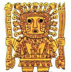
Viracocha was generally depicted as having staves in both of his hands and an aureole, suggests the qualities of a sun god, perhaps holding thunderbolts or lightning bolts associated with Zeus head of the Greek Pantheon of Gods.
The staves might suggest Viracocha's distant ancestry from the nearly thousand years older Chaviacuten sky god in North Peru. His attendants were ranking deities in the shapes of cougar, condor, falcon and snake. Viracocha was worshipped as the main god in Huari as well. There his characteristics were apparently more militant. A head of Tiahuanaco state functioned both as a king and the arch-priest and he was revered as Viracocha's embodiment on Earth.
In Tiwanaku they believed Viracocha allegedly created humans out of rock and brought life to them through the earth. He created giants to move the massive stones that comprise much of their archaeology, but then grew unhappy with the giants and created a flood to destroy them, much like the Flood Stories of Creation, and a metaphor for the flow of the collective unconsciousness or the grids that create the reality (illusion) of our experience.
Viracocha, as a good deity, came to the Andes to restore civilization, culture and knowledge after the Flood. As with nearly all ancient peoples, Inca legend claims that the original people were flood survivors who by hiding in a hollow up on a very high mountain peak, were saved and repopulated the Earth.
Gods with Water Buckets
The Serpent Represents Human DNA, Chromosomes ---> Fetus = Creation
Viracocha is depicted by a water symbol that of the serpent or snake. This is not unlike other myths which mention amphibious gods who came from the heavens (higher frequencies of light), went into the sea (collective unconscious or grids), then moved onto the land (physical reality) and created human civilizations.
Viracocha is carved into the most famous gateway, the Gateway of the Sun, to overlook his people and lands. The Gateway of the Sun is a monolithic structure of regular, non-monumental size. Its dimensions suggest that other regularly-sized buildings existed at the site.
It was found at Kalasasaya, but due to the similarity of other gateways found at Pumapunku it was probably originally part of a series of doorways there. It is recognized for its singular, great frieze which is thought to be some main deity figure surrounded by either calendar signs or natural forces for agricultural worship. Along with Viracocha, another statue is in the Gateway of the Sun.
This statue, many believe, is associated with the weather - a celestial high god that personified various elements of natural forces intimately associated the productive potential of altiplano ecology - the sun, wind, rain, hail - in brief, a personification of atmospherics that most directly affect agricultural production in either a positive or negative manner".
This statue is more complicated than Viracocha in that it has twelve faces covered by a solar mask and at the base thirty running or kneeling figures. Some scientists believe that this statue is a representation of the calendar with twelve months and thirty days in each month.
Viracocha was said to use holy relics such as four skulls of wisdom. When brought together in ceremonial rites, these four skulls delivered enlightenment to the worthy. The power of the skulls was also used to vanquish their enemies by bringing fire from the skies. This sounds a lot like the prophecy of 12 crystal skulls around 1 bought together at the end of time. |
|
|
|
Reply |
Message 41 of 66 on the subject |
|
Legends of the Aymara Indians say that the Creator God Viracocha rose from Lake Titicaca during the time of darkness to bring forth light. Viracocha was a storm god and a sun god who was represented as wearing the sun for a crown, with thunderbolts in his hands, and tears descending from his eyes as rain. He wandered the Earth disguised as a beggar and wept when he saw the plight of the creatures he had created, but knew that he must sustain them. Viracocha made the earth, the stars, the sky and mankind, but his first creation displeased him, so he destroyed it with a flood and made a new, better one, taking to his wanderings as a beggar, teaching his new creations the rudiments of civilization, as well as working numerous miracles. Viracocha eventually disappeared across the Pacific Ocean (by walking on the water), setting off near Manta Ecuador, and never returned. It was thought that Viracocha would re-appear in times of trouble. References are also found of a group of men named the suncasapa or bearded ones. They were the mythic soldiers of Viracocha, or his angelic warriors.
Across from the ruins of Ollantaytambo in the Urubamba Valley stands a sacred mountain
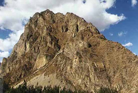
believed to have the profile of Viracocha, the Inca sun god, carved into the stone.
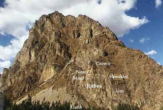
When the sun strikes this profile of Viracocha during the winter solstice, the mineral content of the mountain reflects and refracts the rays. The Inca believed that this was a sign verifying the deity of Viracocha. The solstices were sacred days for the Inca since so much of their culture was based on planting seasons. The buildings to the right and to the left were constructed by the Inca to store corn as food for winters and as offerings to Viracocha. the winter solstice further links with and of a cycle on December 1, 2012 in the Mayan Calendar.
All myths and legends are filled with metaphors and have some basis in fact. One has only to read behind the symbolism of the creational story, then compare it to other creational myths to see how they are all similar in design. In almost all cases creational gods leave, promising to return one day. That day is usually associated with the dawning of a Golden Age when humanity finds peace and moves to another level of consciousness.
The Legend of Creation - 1- Myths about the Ayar brothers
Four pairs of brothers-sisters, created by Viracocha to rule the world, left the cave of Mountain Pacariqtambo. The whole world was living in an uncivilized and ignorant manner. The newcomers began by organizing the mankind and divided people into ten large communities. Leading the tribes the brothers set off in search of enough fertile land to sustain themselves. They carried Sunturpaucar, a long staff adorned with colorful feathers, a cage with a sun-bird who could give good advice and other sacred objects in front of them.
Making shorter and longer stops they moved towards Cuzco. In the course of the long journey the group became smaller: the rivaling brothers confined one of their companions to a cave, two others wished to break away but were turned into stones. The only surviving brother, Ayar Manco, also known as Manco Capak, accompanied by his sister and wife Mama Ocllo and his brothers' wives, founded the city of World Pole in the name of Viracocha the Creator and Inti the Sun God, and settled there with his people.
The Legend of Creation - 2 - Myth of Manco Capak and Mama Ocllo
A long time ago when the world was filled with savages, misery and poverty, a brother and a sister, who were also a married couple - Manco Capak and Mama Ocllo - left Lake Titicaca. Inti, the sun god sent them to refine the surrounding peoples. Inti gave them a golden stick for testing the land for cultivation and then settling in a suitable place. The journey took a long time. Eventually, in the Cuzco Valley the golden stick disappeared into the ground, and they could start with their mission. Manco Capak taught his people the cultivation and irrigation of land and handicrafts. Mama Ocllo taught the women spinning, weaving and sewing. The tribe of Manco Capak was called Hanan Cuzco (Higher Cuzco). The relatives of Mama Ocllo were called Hurin Cuzco (Lower Cuzco). The city and the state was founded in the name of Viracocha and Inti the sun god.
Other Pre-Inca Gods and Goddesses
Apu Inti (Sun God)
Originally acknowledged by Manco Capac, the first Inca, Apu Inti became the keystone in the Incan pantheon of earth-oriented deities. He was the most magnificent creation of Viracocha and the mythological father of the royal Inca line (proposed by Manco Capac, one may surmise, to achieve a status of heavenly mandate). Honored in an array of temples spanning the empire, Apu Inti was worshipped with sacrifice (animal and human) and prayers to golden idols. Ceremonies were conducted in his praise at sunrise and sunset, with fear sweeping the empire during solar eclipses. The Incas, receiving his gift of light and life, referred to themselves as children of the sun.
Manco Capac is sometimes referred to in legend as the Mythical Father of the Incas. According to the most frequently told story, four brothers, Manco Capac, Ayar Anca, Ayar Cachi, and Ayar Uchu, and their four sisters, Mama Ocllo, Mama Huaco, Mama Cura (or Ipacura), and Mama Raua, lived at Paccari-Tampu [tavern of the dawn], several miles distant from Cuzco. They gathered together the tribes of their locality, marched on the Cuzco Valley, and conquered the tribes living there. Manco Capac had by his sister-wife, Mama Ocllo, a son called Sinchi Roca (or Cinchi Roca).
Authorities concede that the first Inca chief to be a historical figure was called Sinchi Roca (c.1105?c.1140). Thus the foundation for an empire was laid. Another legend relates that the Sun created a man and a woman on an island in Lake Titicaca. They were given a golden staff by the Sun, their father, who bade them settle permanently at whatever place the staff should sink into the earth. At a hill overlooking the present city of Cuzco the staff of gold disappeared into the earth. They gathered around them a great many people and founded the city of Cuzco and the Inca state.
Chiqui Illapa (Thunder God)
Second only to Apu Inti, Chiqui Illapa was a magnanimous figure in Incan lore. Hailing rain down from the celestial river (the Milky Way), Illapa fed the empire. Incan legend asserts that he would crack his sister's water jug with a slingshot, reverberating the echoes of thunder as aqueous elixir spilled forth from the sky, showering the parched lands below. He was associated with Keypachu, the upper kingdom of heaven, and was worshipped throughout the growing season. Interestingly, any male child born during a thunderstorm was declared a priest of Chiqui Illapa, an exalted position in Incan society and within the priestly class itself.
Mamaquilla (Mother Moon)
First acknowledged by Inca Yapanqui, successor of Manco Capac, Mamaquilla was wife of the sun and timekeeper of the heavens. As the Incan calendar revolved around the lunar month, she was critical to the maintenance of a calendrical system that would ensure proper adherence to planting and harvesting seasons. She was represented with idols of silver, complementing the gold of her luminary husband.
Yakumama (Mother Water)
Yakumama was believed to control subterranean and mountain streams, blessing the fields with nourishment and springing fresh water from the earth. The complement of Chiqui Illapa, she was associated with ukupacha, the lower kingdom of heaven.
Mamacocha (Mother Sea)
A regional deity, Mamacocha was important to ayllus of the Peruvian coast, where she maintained the fertility of the sea. She was honored with conch shells, which were more valuable in this region than gold or silver.
Pachakama (Earth Mother)
Pachakama was also a regional deity, important to the Andean highlanders. She was ascribed the role of ensuring the fertility of soil and seed in the harsh mountain climates.
Stars
In the tradition of celestial deities, stars were thought to possess spirits that breathed life into earthly beings. Several constellations were also recognized as bearing agricultural import, such as the Pleiades, the "Seven Sisters" who preserved the seed, and the "Great Lizard", who appeared in the west during planting season and buried his head in the east at harvest time.
Waca
Waca were the family gods, or, synonymously, the shrines in which the family gods were worshipped. They were honored with more regularity than any deity of the state-recognized pantheon, as they wielded direct control over the prosperity of the ayllu. Wacas took a variety of forms, the most common being mountains, streams, caves, trees, or roads. Idols appropriate to their form were worshipped on a daily basis to appease them and avert the evocation of manevolence. Curiously, oddities such as twins, abnormal plants, and disfigured animals were also considered Wacas. In addition to the Waca of the kin group, individuals also had a personal guarding spirit of similar significance.
Further Religious Practices
Evidence also points to a system of ancestor worship at Tiwanaku. The preservation, use, and reconfiguration of mummy bundles and skeletal remains, like the later Inca, may suggest that this is the case.
Later cultures within the area made use of large "above ground burial chambers for the social elite, known as "chullpas". Similar, though smaller, structures were found within the site of Tiwanaku. Kolata suggests that, like the later Inka, the inhabitants of Tiwanaku may have practiced similar rituals and rites in relation to defunct. The Akapana East Building has evidence of ancestor burial. In comparison to the brutal treatment of the dead on top of the Akapana, the human remains at Akapana East seem to be much less for show and more so for proper burial. The skeletons show many cut marks that were most likely made by removing the flesh after death. Then these individuals were bundled up and buried rather than left out in the open.
Archaeology
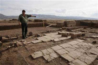
Much of the architecture of the site is in a poor state of preservation, having been subjected to looting and amateur excavations attempting to locate valuables since shortly after Tiwanaku's fall. This destruction continued during the Spanish conquest and colonial period, and during 19th century and the early 20th century, and has included quarrying stone for building and railroad construction and target practice by military personnel.
Another issue for archaeologists is the lack of standing buildings at the modern site. Only public, non-domestic foundations remain, with poorly reconstructed walls. The ashlar blocks used in many of these structures were mass-produced in similar styles so that they could possibly be used for multiple purposes. Throughout the period of the site certain buildings changed purposes causing a mix of artifacts that are found today.
Detailed study of Tiwanaku began on a small scale in the mid-nineteenth century. In the 1860s, Ephraim George Squier visited the ruins and later published maps and sketches completed during his visit. German geologist Alphons StŸbel spent nine days in Tiwanaku in 1876, creating a map of the site based on careful measurements. He also made sketches and created paper impressions of carvings and other architectural features.
A book containing major photographic documentation was published in 1892 by engineer B. von Grumbkow. With commentary by archaeologist Max Uhle, this was the first in-depth scientific account of the ruins.
In the 1960s, an attempt was made at restoring the site, but by very uninformed parties. The walls pictured to the right, of the Kalasasaya, are almost all reconstruction. The original stones making up the Kalasasaya would have resembled a more "Stonehenge" like style, spaced evenly apart and standing straight up.
Unfortunately, the parties that made the reconstructions decided to make the Kalasasaya be enclosed by a wall that they themselves built. Ironically enough, the reconstruction itself is actually much poorer quality stoneworking than the people of Tiwanaku were capable of. It should also be noted that the Gateway of the Sun, that now stands in the Kalasasaya, is not in its original location, having been moved sometime earlier from its original location, which is unknown.
Modern, academically-sound archaeological excavations were performed from 1978 through the 1990s by University of Chicago anthropologist Alan Kolata and his Bolivian counterpart, Oswaldo Rivera. Among their contributions are the rediscovery of the suka kollus, accurate dating of the civilization's growth and influence, and evidence for a drought-based collapse of the Tiwanaku civilization.
Archaeologists like Paul Goldstein argue that the Tiwanaku empire ranged outside of the altiplano area and into the Moquegua Valley in Peru. Excavations at Omo settlements show signs of similar architecture characteristic of Tiwanaku such as a temple and terraced mound. Evidence of similar types of cranial deformation in burials between the Omo site and the main site of Tiwanaku is also being used for this argument.
Lukurmata
Lukurmata was an important secondary site near Lake Titicaca in Bolivia. First established nearly two thousand years ago, it grew to be a major ceremonial center in the Tiwanaku state, a polity that dominated the south-central Andes from a.d. 400 to 1200. After the Tiwanaku state collapsed, Lukurmata rapidly declined, becoming once again a small village. The site also shows evidence of extensive occupation that pre-dates the Tiwanakan civilization.
Present Day
Today Tiwanaku is a UNESCO world heritage site, and is administered by the Bolivian government.
Recently, the Department of Archaeology of Bolivia (DINAR, directed by Javier Escalante) has been conducting excavations on the Akapana pyramid. The Proyecto Arqueologico Pumapunku-Akapana (PAPA, or Pumapunku-Akapana Archaeological Project) run by the University of Pennsylvania, has been excavating in the area surrounding the pyramid for the past few years, and also conducting Ground Penetrating Radar surveys of the area.
In previous years, an archaeological field school offered through Harvard's Summer School Program, conducted in the residential area outside the monumental core, has provoked controversy amongst local archaeologists. The program was directed by Dr. Gary Urton of Harvard, expert in quipu, and Dr. Alexei Vranich of the University of Pennsylvania.
The controversy had to do with fact that permission to excavate Tiwanaku, being such an important site, is only provided to certified professional archaeologists and rarely to independent Bolivian scholars who scarcely can present proof of funding to carry on archaeological research. On that occasion permission was given to Harvard's Summer School to allow a team mostly composed of untrained students to dig the site. The controversy, charged with nationalistic and political undertones that characterized the archaeology of Tiwanaku faded rapidly without any response from the directors, however, the project did not continue in subsequent years.
Because nearby quarries are lacking, scholars marvel at the large blocks used to construct stone structures at Tiwanaku. The red sandstone used in the pyramid have been determined by petrographic analysis to come from a quarry 10 kilometers away - a remarkable distance considering that one of the stones alone weighs over 130 tons. The green andesite stones that were used to create the most elaborate carvings and monoliths originate from the Copacabana peninsula, located across Lake Titicaca. One theory is that these giant andesite stones, which weigh up to 40 tons were transported some 90 kilometers across Lake Titicaca on reed boats, then laboriously dragged another 10 kilometers to the city.
In 2009 state-sponsored restoration work on the Akapana pyramid was halted due to a complaint from UNESCO. The restoration had consisted in plastering the pyramid with adobe, despite it being unclear whether or not the result would bring the pyramid back to its original state.
Tiahuanaco and the Deluge
By Helmut Zettl
Cradled in the basin of the Peruvian-Bolivian altiplano, the Titicaca region is currently densely populated by the Aymara Indians, who eke out an agricultural existence, subsisting primarily on maize, frozen potatoes, and chicha, a fermented alcoholic beverage made of cornmeal.
There is evidence that such was not always the case. Just 12 miles southward of the southernmost tip of Lake Titicaca lie the remains of Tiahuanaco, the site of a technologically advanced culture considered by many archaeologists (romantic not orthodox) to be the oldest ruins in the world. Although some misguided scholars have attributed the buildings of Tiahuanaco to the Incas, it has now been established that the city was already in ruins when the first Incas came upon the scene.
In 1540 the Spanish chronicler, Pedro Cieza de Leon, visited the area and his description of the statues and monoliths compares very closely to what we see today. The site is at an altitude of 13,300 feet, which places it some 800 feet above the present level of Lake Titicaca. Most archaeologists agree that in the distant past Tiahuanaco was a flourishing port at the edge of the lake, which means that the water has receded almost 12 miles and has dropped about 800 feet since then. All concur that the lake is shrinking, due mainly to evaporation, since no rivers flow from it.
At this altitude of 13,300 feet some of the remains are found at a level 6 feet below the earth's surface. The mountain ranges which surround the area are not high enough to permit sufficient runoff of water or wind erosion to have covered the ruins to such a depth. This remains a mystery to this day.
Legends have persisted over the centuries that there are stone structures beneath the waters of Lake Titicaca, much the same kind as can be found on the lake's shore. The Indians of that legion have frequently recounted this tradition, but until recently there has been no proof of such structures.
In 1968 Jacques Cousteau, the French underwater explorer, took his crew and equipment there to explore the lake and search for evidence of underwater construction. Although severely hampered in their activities by the extreme altitude, the divers spent many days searching the lake bottom, in the vicinity of the islands of the Sun and Moon, but found nothing man-made. Cousteau concluded the legends were a myth.
In November 1980, however, the well known Bolivian author and scholar of pre-Columbian cultures, Hugo Boero Rojo, announced the finding of archaeological ruins beneath Lake Titicaca about 15 to 20 meters below the surface off the coast of Puerto Acosta, a Bolivian port village near the Peruvian frontier on the northeast edge of the lake.
Based upon information furnished by Elias Mamani. a native of the region who is over 100 years old, Boero Rojo and two Puerto Ricans cinematographers, Ivan and Alex Irrizarry, were able to locate the ruins after extensive exploration of the lake bottom in the area, while filming a documentary on the nearby Indians. Rojo stated, "We can now say that the existence of pre-Columbian constructions under the waters of Lake Titicaca is no longer a mere supposition or science-fiction, but a real fact. The remnants found show the existence of old civilizations that greatly antecede the Spanish colonization. We have found temples built of huge blocks of stone, with stone roads leading to unknown places and flights of steps whose bases were lost in the depths of the lake amid a thick vegetation of algae. Boero Rojo described these monumental ruins as being of probable Tiahuanaco origin."
Polish-born Bolivian archaeologist Arturo Posnansky has concluded that the Tiahuanaco culture began in the region at about 1600 B.C. and flourished until at least 1200 A.D. His disciple, Professor Hans Schindler-Bellamy, believed Tiahuanaco to have reached back 12,000 years before the present era, although a more conservative Peruvian archaeologist.
What happened to the advanced ancient culture, however, has not yet been determined. Rojo's discovery nevertheless may prove to create more problems than it solves. If, over the past 3 or 4000 years Lake Titicaca has slowly receded, as appears to be the case-as all scientists agree, then how can we explain the existence of stone temples, stairways, and roads still under water'? The only answer is that they were built before the lake materialized. We must go back, then, to the remnants of Tiahuanaco and re-examine the more than 400 acres of ruins, only 10 percent of which have been excavated. We have pointed out that dirt covers the ancient civilization to a depth of at least 6 feet. The only explanation for this accumulation is water.
A large amount of water had to have inundated the city. When it receded it left the silt covering all evidence of an advanced civilization, leaving only the largest statues and monoliths still exposed. It is logical to conclude, therefore, that Tiahuanaco was built before the lake was created, and not as a port on its shore. As the waters today continue to recede, we should be able to find more evidence of the city's remote peoples.
Scientists theorize that the area of Lake Titicaca was at one time at sea level, because of the profusion of fossilized marine life which can be found in the region. The area then lifted with the Andean upheaval and a basin was created which filled in to form the lake. No one has suggested the marine life might have been brought to the altiplano by sea waters which were at flood stage.
Peruvian legends clearly relate a story of world-wide flood in the distant past. Whether it was the biblical flood of Noah, or another one, we cannot say, but there is ample physical evidence of a universal inundation, with the world-wide deluge described in more than a hundred flood-myths. Along with Noah's flood were the Babylonian Utnapischtim of the Gilgamesh epic, the Sumerian Ziusudra, the Persian Jima, the Indian Manu, the Maya Coxcox, the Colombian Bochica, the Algonkin's Nanabozu, the Crows' Coyote, the Greek Deukalion and Pyrrha, the Chinese Noah Kuen, and the Polynesian Tangaloa. It is evident there was a world-wide deluge 19,000 years ago.
(Global doomsdays are conspicuous in the Hopi Indian legends, the Finnish Kalevala epic, the Mayan Chilam Balam and Popol Vuh, and in the Aztec calendar, the last of which predicts that our present civilization will be destroyed by "nahuatl Olin" or "earth movement," that is, devastation by earthquake.
|
|
|
|
Reply |
Message 42 of 66 on the subject |
|
|
Due to Aztec cyclic theory this will become the fifth doomsday after the "death of the Jaguars," "the death of the Tempests," "the death of the Great Fire" (vulcanism), and the 'Great Deluge.' If a flourishing advanced civilization existed on the Peruvian altiplano many thousands of years ago and was reached by the flood waters, many problems would be solved, such as the existence of Tiahuanaco's ruins under 6 feet of earth at an elevation of 13,300 feet. The presence of stone structures still under the lake's waters and the existence of marine life at an impossible altitude would also make sense.
In my 1978 and 1984 trips to Peru I was impressed by agricultural terracing on the sides and very tops of the steep peaks. These appear to be the oldest - and now unused-portions of the terracing. As you look down the mountains you see more and more terraces of more recent origin. We are told that only the Inca (specifically the Sapai Inca, i.e. the ruler) could use the lower portions and the fertile valleys. The peons had to climb to the very peaks to cultivate the soil for their own subsistence.
But then, I wondered, it must have been very tough in the fall to carry the harvest 2 to 3000 feet down to the valley floor. Then it struck me. If there really had been a world-wide deluge covering most of the earth's surface - leaving only mountain tops protruding in the sunlight - then the two remaining survivors of the deluge would naturally plant their seeds on mountain tops. They had no problem getting produce down, because they lived at the top.
Also, they used boats to move from one peak to another. As the flood waters receded the terracing began to creep down the mountain sides, as can be seen today, with the ones near the bottom being the freshest. As Boero Rojo stated, "The discovery of Aymara structures under the waters of Lake Titicaca could pose entirely new theses on the disappearance of an entire civilization, which, for some unknown reason, became submerged.
The Tiahuanacans could have been victims of world-wide flood, their civilization all but wiped out when their homes and structures were covered with sea water. Because of the basin-like geography of the area the flood waters that became Lake Titicaca could not run off and have only gradually evaporated over the centuries.
Professor Schindler-Bellamy as a disciple of Posnansky and Horbiger (who created the world famous Glacial-Cosmogony theory in the 1930's - has worked dozens of years in the Tiahuanaco area and has written books on the subject.
According to him the large monolithic Sun Gate of Tiahuanaco was evidently originally the centerpiece of the most important part of the so-called Kalasasaya, the huge chief temple of Tiahuanaco. Its upper part is covered with a stupendously intricate sculpture in flat bas relief. This has been described as a "calendar" almost as long as the monolithic gateway has been known to exist; thus the Sun Gate has also been called 'the Calendar Gate'. This calendar sculpture, though it undoubtedly depicts a "solar year," cannot however be made to fit into the solar year as we divide it at present.
After many futile attempts had been made, by employing a Procrustean chopping off of toes or heels to make the calendar work, the sculpture - which indeed has a highly decorative aspect-was eventually declared generally to be nothing but an intricate piece of art.
Professor Schindler-Bellamy and the American astronomer Allen have nevertheless continued to insist the sculpture was a calendar, though one of a special kind, designed for special purpose, and, of course, for a special time. Hence it must refer exclusively to the reckoning of that time, and to certain events occurring then. Consequently we cannot make the calendar "speak" in terms of our own time, but let it speak for itself - and listen to what it says and learn from it. When we do so we gain an immense insight into the world of the people of that era, into the manner of thinking of their intellectuals, and generally into the way their craftsmen and laborers lived and worked.
To describe these things in detail would make a long story; it took l) R. Allen and Professor Schindler-Bellamy and their helpers many years of hard work to puzzle out the Tiahuanaco system of notation and its symbology, and to make the necessary calculations (before the age of computers). The result was a book of over 400 pages, The Calendar of Tishuanaco,published in 1956.
Thorough analysis of the Sun (Sate sculpture revealed the astonishing fact that the calendar is not a mere list of days for the "man in the street" of the Tiahuanaco of that time, telling him the dates of market days or holy days; it is actually, and pre-eminently a unique depository of astronomical, mathematical, and scientific data- the quintessence of the knowledge of the bearers of Tiahuanacan culture.
The enormous amount of information the calendar has been made to contain-and to impart to anyone ready and able to read it is communicated in a way that is, once the system of notation has been grasped, singularly lucid and intelligible, "counting by units of pictorial or abstract form. The different forms of those units attribute special, very definite and important additional meanings to them, and make them do double or multiple duty.
By means of that method "any number" can be expressed without employing definite "numerals" whose meaning might be difficult, if not impossible, to establish. "It is only necessary to recognize the units and consider their forms, and find their groupings, count them out, and render the result in our own numerical notation.
Some of the results seem to be so unbelievable that superficial critics have rejected them as mere arrant nonsense. But they are too well dove-tailed and geared into the greater system (and in some cases supported by peculiar repetitions and cross-references) to be discarded in disgust; one has to accept them as correct. Whoever rejects them, however, also accepts the onus of offering a better explanation, and Professor Schindler-Bellamy has the "advantage of doubt," at any rate.
The "solar year" of the calendar's time had very practically the same length as our own, but, as shown symbolically by the sculpture, the earth revolved more quickly then, making the Tiahuanacan year only 290 days, divided into 12 "twelfths" of 94 days each, plus 2 intercalary days. Tilese groupings (290, 24, 12, 2) are clearly and unmistakably shown in the sculpture. The explanation of 290 versus 3651/4 days cannot be discussed here.
At the time Tiahuanaco flourished the present moon was not yet the companion ol our earth but was still an independent exterior planet. There was another satellite moving around our earth then, rather close-5.9 terrestrial radii, center to center; our present moon being at 60 radii. Because of its closeness it moved around the earth more quickly than our planet rotated. Therefore it rose in the west and set in the east (like Mars' satellite Phobos), and so caused a great number of solar eclipses, 37 in one "twelfth," or 447 in one "solar year " of course it caused an equal number of satellite eclipses. These groupings (37, 447) are shown in the sculpture, with many Corroborating cross-references. Different symbols show when these solar eclipses, which were of some duration, occurred: at sunrise, at noon, at sunset.
These are only a small sample of the exact astronomical information the calendar gives. It also gives the beginning of the year, the days of the equinoxes and solstices, the incidence of the two intercalary days, information on the obliquity of the elliptic (then about 16.5 degrees; now 23.5) and on Tiahuanaco's latitude (then about 10 degrees; now 16.27), and many other astronomical and geographical references from which interesting and important data may be calculated or inferred by us.
Tiahuanacan scientists certainly knew, for instance, that the earth was a globe which rotated on its axis (not that the sun moved over a flat earth), because they calculated exactly the times of eclipses not visible at Tiahuanaco but visible in the opposite hemisphere (One wonders whether they were actually able to travel around the world, and speculate in what sort of vessel ! )
A few more facts revealed in the calendar are both interesting and surprising As indicated by an arrangement of "geometrical" elements we can ascertain that the Tiahuanacans divided the circle factually astronomically, but certainly mathematically} into 264 degrees (rather than 360).
Also, they determined-ages before Archimedes and the Egyptians the ratio of pi, the most important ratio between the circumference of the circle and its diameter, as 22/7, or, in our notation, 3.14+. They could calculate squares (and hence, square roots).
They knew trigonometry and the measuring of angles (30, 60, 90 degrees) and their functions- They could calculate and indicate fractions, but do not seem to have known the decimal system nor did they apparently ever employ the duodecimal system though they were aware of it.
(For a still unknown reason, however, the number 11 and its multiples occur often.) They were able to draw absolutely straight lines and exact right angles, but no mathematical instruments have yet been found.
We must take notice of the evident parallels with the markings of the Nazca Plain. We do not know the excellent tools they must have used for working the glass-hard andesine stone of their monuments, cutting, polishing, and incising. They must have employed block and tackle for lifting and transporting great loads (up to 200 tons) over considerable distances and even over expanses of water from the quarries to the construction sites. It is difficult to see how all the calculations, planning, and design work involved in producing the great city of Tiahuanaco could have been done without some form of writing, and without a system of notation different from the "unit" system of the calendar sculpture.
If they had such a system they must have used it only on perishable materials. (One is Tempted to think all these Nasca markings had been constructed by Atlanteans who fled to the altiplano before or after the destruction of their island continent 12,000 years ago.) I have so far dealt with some of the aspects of the Tiahuanacan world, namely those connected with the calendar as a monument of what Schindler-Bellamy describes as "fossilized science."
But the calendar science-sculpture, and similar slightly older ones also found at the site, must also be regarded and appreciated from an aesthetic point of view, a great artistic achievement in design and execution-and an absolute masterpiece of arrangement and layout.
The most tantalizing fact of all is that the Tiahuanaco culture has no roots in that area. It did not grow there from humbler beginnings, nor is any other place of origin known. It seems to have appeared practically full blown suddenly.
Only a few "older" monuments, as can be inferred from the "calendrical inscriptions" they bear, have been found, but the difference in time cannot have been very great. The different-much lower cultures discovered at considerable distances from Tiahuanaco proper, addressed as "Decadent Tiahuacan" or as "Coastal Tiahuanaco," are only very indirectly related to the culture revealed by the Calendar Cate. Some of their painted symbols are somehow somewhat related to the calendar symbols, but they make no sense whatever; they are, if anything, purely ornamental.
Tiahuanaco apparently remained for only a very short period at its acme of perfection (evidenced by the Calendar Gate) and perished suddenly, perhaps through the cataclysmic happenings connected with the breakdown of the former "moon."
We have at present no means of determining when Tiahuanaco rose to supreme height. or when its culture was obliterated, and naturally, the calendar itself can tell us nothing about that. It will certainly not have been in the historical past but well back in the prehistoric. It must indeed have occurred before the planet Luna was captured as the earth's present moon, about 12,000 years ago.
The capture of the satellite and its later fall to the surface on our planet imposed great stresses on the earth. The gravitational pull caused floods and earthquakes until the moon settled into a stable orbit one-fifth of today's distance. Hence the "moon" draws the oceans into a belt or bulge around the equator, drowning the equatorial region but leaving the polar lands high and dry.
When the satellite approached within a few thousand miles gravitational forces broke it up; according to the Roche formula each planetoid or asteroid disintegrates when approaching the critical distance of 50 to 60,000 kms. The fragments shattered down on earth; the oceans, released from the satellite's gravity, flowed back toward the continents, exposing tropical lands and submerging polar territories. This is the simple explanation of the Horbiger theory, and it seems to me the most logical one. Thus the approach of the "moon" caused a world-wide deluge, effecting changes of climate and provoking earthquakes accompanied by volcanic eruptions.
The "ring" left by the satellite after breaking into fragments caused a sudden drop in temperature of at least 20 degrees, which geologists recognize as its decline" in temperature. It is evident, for example, in the discovery of frozen mammoths in the Siberian tundra. Possibly gravity-and therefore physical weight - was also changed on earth, and with it biological growth: this would explain the widespread construction of huge megalithic monuments as well as the presence of giants-man and animal-in fossil strata, tombs, and myths.
According to Horbiger four moons fell on earth, producing four Ice Ages; our present moon, the fifth one, will similarly be drawn into the critical configuration of one-fifth of its present distance (380,000 kms.) and will cause the fifth cataclysm.
The theory of a falling moon has recently been substantiated by Dr. John O'Keefe, a scientist at the Coddard Laboratory for Astronomy in Maryland. Dr. O'Keefe claims that the fragments of a moon's collision formed a ring around our planet that could have kept the sun's rays from penetrating to earth, thus causing world-wide decline of temperatures. After a while the fragments showered down on earth, breaking into smithereens known as tectites. These tectites O'Keefe believes were fragments of the fallen moon, thus proving Horbiger 's World-lce-Cosmology.
The Calendar Gate shows that a far-advanced culture made a substantial attempt to plant its society at Tiahuanaco, wanting to revitalize this region which had already been devastated by floods caused by a close satellite. Their attempt eventually miscarried, because they had underestimated certain dangerous developments that ultimately happened contrary to all expectations and calculations.
ShareThis
INCA CIVILIZATION INDEX
ANCIENT CIVILIZATIONS INDEX
ALPHABETICAL INDEX OF ALL FILES
CRYSTALINKS HOME PAGE
PSYCHIC READING WITH ELLIE
2012 THE ALCHEMY OF TIME
http://www.crystalinks.com/tiwanaku.html
|
|
|
Gate of the Sun
From Wikipedia, the free encyclopedia
For the Inca trail related to Machu Picchu, see Intipuncu.
The so-called Gate of the Sun is a megalithic solid stone arch or gateway constructed by the ancient Tiwanaku culture of Bolivia over 1500 years before the present. [1]
It is located near Lake Titicaca at about 3,825 m above sea level near La Paz, Bolivia. The object is approximately 9.8 ft (3.0 m) tall and 13 ft (4.0 m) wide, and is constructed from a single piece of stone. The weight is estimated to be 10 tons. When rediscovered by European explorers in the mid-19th century, the megalith was lying horizontally and had a large crack going through it. It currently stands in the same location where it was found, although it is believed that this is not its original location, which remains uncertain.[2]
The Gate of the Sun is a valuable monument to the history of art and ancient architecture. Some elements of Tiwanaku iconography spread throughout Peru and parts of Bolivia. Although there have been various modern interpretations of the mysterious inscriptions found on the object, the engravings that decorate the gate are believed to possess astronomical and/or astrological significance and may have served a calendrical purpose.[3]
[edit] Figures on Gate of the Sun
The lintel is carved with 48 squares surrounding a central figure. Each square represents a character in the form of winged effigy. There are 32 effigies with human faces and 16 with condor's heads. All look to the central figure, whose identity remains an enigma. It is a figure of a man with the head surrounded by 24 linear rays that may represent rays of solar light. The styled staffs held by the figure apparently symbolize thunder and lightning. Some historians and archaeologists believe that the central figure represents the “Sun God” judging by the rays emitted from it head, while others have identified it with the Inca god Viracocha.
|
|
|
|
|
|
Reply |
Message 43 of 66 on the subject |
|
LA SANGRE DEL CORDERO EN EL DINTEL, EN CONTEXTO AL EXODO PASCUAL, ES UN TIPO DEL GRIAL
1. Éxodo 12:7: Y tomarán de la sangre, y la pondrán en los dos postes y en el DINTEL de las casas en que lo han de comer.
2. Éxodo 12:22: Y tomad un manojo de hisopo, y mojadlo en la sangre que estará en un lebrillo, y untad el DINTEL y los dos postes con la sangre que estará en el lebrillo; y ninguno de vosotros salga de las puertas de su casa hasta la mañana.
3. Éxodo 12:23: Porque Jehová pasará hiriendo a los egipcios; y cuando vea la sangre en el DINTEL y en los dos postes, pasará Jehová aquella puerta, y no dejará entrar al heridor en vuestras casas para herir.
Dintel
De Wikipedia, la enciclopedia libre

Esquema de estructura adintelada.
Un dintel es un elemento estructural horizontal que salva un espacio libre entre dos apoyos. Es el elemento superior que permite abrir huecos en los muros para conformar puertas, ventanas o pórticos. Por extensión, el tipo de arquitectura, o construcción, que utiliza el uso de dinteles para cubrir los espacios en los edificios se llama arquitectura adintelada, o construcción adintelada. La que utiliza arcos o bóvedas se denomina arquitectura abovedada.
Los mejores exponentes de arquitectura adintelada en piedra son los edificios monumentales del Antiguo Egipto y la Grecia clásica. La palabra dintel proviene de la palabra latina: limitellus, que deriva etimológicamente de limen y limes. En latín la palabra limen significa umbral, puerta, entrada o comienzo, y limes se refiere a un sendero entre dos campos, límite o muralla.
[editar] Resistencia
Para un dintel cuyos extremos recaigan sobre los elementos verticales cuyo espacio libre salva el dintel, las mayores tensiones se da sobre la sección transversal central. En este caso, la tensión sobre el dintel, si éste es de canto pequeño en relación a la longitud, puede calcularse a partir de la teoría de vigas de Euler-Bernouilli para la flexión mecánica de vigas (si el canto es apreciable en relación a la longitud debe emplerarse la teoría de Timoschenko, que considera igualmente el efecto del esfuerzo cortante). En el caso anterior, la flexión hace que la parte superior del mismo esté comprimida, y la inferior esté traccionada.
Los materiales rígidos como las rocas (el hormigón y otros materiales de tipo cerámico) soportan peor los esfuerzos de tracción que los de compresión, por lo que la patología más habitual en los dinteles pétreos son las fisuras que surgen desde la parte inferior de la cara inferior y progresan hasta la parte superior.
|
|
Bermejo Map — Satellite Images of Bermejo
original name: Bermejo geographical location: Arce, Tarija, Bolivia, South America geographical coordinates: 22° 39' 0" South, 64° 22' 0" West
detailed map of Bermejo and near places
 Welcome to the Bermejo google satellite map! This place is situated in Arce, Tarija, Bolivia, its geographical coordinates are 22° 39' 0" South, 64° 22' 0" West and its original name (with diacritics) is Bermejo. See Bermejo photos and images from satellite below, explore the aerial photographs of Bermejo in Bolivia. Bermejo hotels map is available on the target page linked above. Welcome to the Bermejo google satellite map! This place is situated in Arce, Tarija, Bolivia, its geographical coordinates are 22° 39' 0" South, 64° 22' 0" West and its original name (with diacritics) is Bermejo. See Bermejo photos and images from satellite below, explore the aerial photographs of Bermejo in Bolivia. Bermejo hotels map is available on the target page linked above.
http://www.maplandia.com/bolivia/tarija/arce/bermejo/
|
|
|
|
|
Fiesta Nacional de los Estudiantes, Jujuy, Capital Nacional de la Primavera y la Juventud y Juntos en Jujuy
17 al 22 de Septiembre
Son los lemas que identifican cada año a esta fiesta que se realiza en Jujuy en primavera. Las calles de la ciudad pintadas de colores y la algarabía de los estudiantes que preparan las carrozas y carruajes, llenos de flores y luces, dan un marco extraordinario a los desfiles, a los bailes y a los espectáculos musicales.
La Fiesta culmina con la elección de la Reina Nacional de los Estudiantes.
Virgen de Río Blanco y Paypaya
Octubre
Todo Jujuy honra a su patrona con actos litúrgicos. Durante los cuatro domingos del mes se realiza las peregrinaciones hasta el Santuario de la Virgen situado en la localidad de “Río Blanco”, distante a siete kilómetros de la capital provincial.
Atractivos Turísticos
· Plaza Belgrano
· Palacio de Gobierno
· Iglesia Catedral
· Iglesia de San Francisco
· Iglesia de Santa Bárbara
· Museo de San Francisco
· Bellas Artes
· Museo Mineralógico y Paleontológico
· Termas de Lagunas de Yala
· Termas de Reyes
· Termas de Caimancito
· Nevado de Chañi
· Termas de El Palmar: Chorro de Plata, El Idolo, Fuente Roja
· Parque Nacional Calilegua
La Quebrada de Humahuaca, pueblo fundado en 1.591. Se caracteriza por hermosos paisajes que armonizan con sus casas de adobe y calles angostas y empedradas, donde el tiempo parece haberse detenido. La iglesia construida en el siglo XVI (se remonta a 1648), tiene un altar profusamente dorado. Se venera la Virgen de la Candelaria.
Uno de los principales atractivos de esta quebrada es el Pucará de Tilcara, una población fortificada construida por los nativos omaguacas en épocas precolombinas.
El monolito que marca el Trópico de Capricornio es donde el día 21 de junio se celebra el Inti Raymi (Fiesta del Sol), celebración de antigua tradición aymará que se hace, en el momento que comienza el solsticio de invierno, para recibir el nuevo ciclo agrícola.
Termas de Reyes, ubicada a 19 kilómetros de Jujuy esta el surgente termal de imponderable valor terapéutico que está emplazado en el pintoresco valle.
Dique La Ciénaga, ubicado a 31 kilómetros de Jujuy se encuentra este hermoso embalse. Se practican la pesca y los deportes náuticos.
http://www.argentinacontact.com/es/conozca/jujuy.php
|
|
|
|
|
|
Reply |
Message 44 of 66 on the subject |
|
Inti Raymi
De Wikipedia, la enciclopedia libre
| Inti Raymi |

Fiesta del Inti Raymi en Sacsayhuamán |
| Tipo |
ceremonia incaica |
| Celebrada por |
Descendientes herederos de la tradición incaica |
| Ubicación |
Perú - Ecuador |
| Fecha |
24 de Junio |
| Motivo |
Solsticio de invierno |
Inti Raymi (en quechua ‘fiesta del Sol’) era una antigua ceremonia religiosa andina en honor al Inti (el dios sol), que se realizaba cada solsticio de invierno en los Andes.
Durante la época de los incas, el Inti Raymi era el más importante de los cuatro festivales celebrados en el Cusco, según relata el Inca Garcilaso de la Vega (1539-1616), e indicaba la mitad del año así como el origen mítico del Inca. Duraba 15 días, en los cuales había bailes y sacrificios. El último Inti Raymi con la presencia del emperador inca fue realizado en 1535.
En 1572 el virrey Francisco de Toledo (1515-1584) la prohibió por considerarla una ceremonia pagana y contraria a la fe católica. Se siguió realizando de manera clandestina.[1]
En 1944, Faustino Espinoza Navarro efectuó una reconstrucción histórica del Inti Raymi. La reconstrucción se basa en la crónica de Garcilaso de la Vega y sólo se refiere a la ceremonia religiosa. Desde esa fecha en adelante, la ceremonia vuelve a ser un evento público y de gran atractivo turístico.
Aunque hoy conocemos a esta celebración con su nombre quechua de Inti Raymi, en realidad se trata de una festividad común a muchos pueblos prehispánicos de los Andes, y que seguramente precede con mucho a la formación del Imperio incaico.
El Inti Raymi aún se celebra como rito sincrético en muchas comunidades andinas. En el callejón interandino septentrional del Ecuador, por ejemplo, el conjunto de festividades relacionadas abarca todo el mes de junio y parte de julio, teniendo cada ciudad sus propios ritos y costumbres, y llegando a paralizarse la vida cotidiana como efecto de las celebraciones, que toman las avenidas noche y día.

Celebración del Inti Raymi en Chibuleo - Ecuador. La foto corresponde a las celebraciones en el año 2008.
En la época de los incas, esta ceremonia se realizaba en la plaza Aucaypata (hoy Plaza de armas del Cusco), con la asistencia de la totalidad de la población de la urbe, tal vez unas cien mil personas. Con la llegada de los españoles, fue suprimida.
En el solsticio de invierno sucede el día más corto y la noche más larga del año. Durante la época incaica, ese hecho revestía fundamental importancia, pues era el punto de partida del nuevo año, que se asociaba con los orígenes de la propia etnia inca. Inca Garcilaso de la Vega nos dice que era ésta la principal fiesta y a ella concurrían «los curacas, señores de vasallos, de todo el imperio [...] con sus mayores galas e invenciones que podían haber». La preparación era estricta, pues en los previos «tres días no comían sino un poco de maíz blanco, crudo, y unas pocas de yerbas que llaman chúcam y agua simple. En todo este tiempo no encendían fuego en toda la ciudad y se abstenían de dormir con sus mujeres». Para la ceremonia misma, las vírgenes del Sol preparaban unos panecillos de maíz.
Ese día, el soberano y sus parientes esperaban descalzos la salida del sol en la plaza. Puestos en cuclillas («que entre estos indios es tanto como ponerse de rodillas», aclara el cronista), con los brazos abiertos y dando besos al aire, recibían al astro rey. Entonces el inca, con dos vasos de oro, brindaba la chicha: del vaso que mantenía en la mano izquierda bebían sus parientes; el de la derecha era derramado y vertido en un tinajón de oro.
Después todos iban al Coricancha y adoraban al sol. Los curacas entregaban las ofrendas que habían traído de sus tierras y luego el cortejo volvía a la plaza, donde se realizaba el masivo sacrificio del ganado ante el fuego nuevo que se encendía utilizando como espejo el brazalete de oro del sacerdote principal. La carne de los animales era repartida entre todos los presentes, así como una gran cantidad de chicha, con la que los festejos continuaban durante los siguientes días.
[editar] Representación contemporánea
En el Cusco de hoy, el Inti Raymi, como no podía ser de otro modo, tiene un carácter distinto, de espectáculo dirigido tanto a los turistas como a los propios cusqueños, para quienes es un punto de referencia de su conciencia local. Por esto último concita tanto entusiasmo y participación masiva.
La representación, en la que intervienen miles de personas, empieza frente al Coricancha, donde un inca (rey) ficticio realiza una invocación al Sol. Los espectadores, entre tanto, esperan en la explanada de Sacsayhuamán, hacia la que el cortejo se desplaza de inmediato. Éste ingresa al escenario llevando al inca en su litera por grupos que representan a los pobladores de los cuatro suyos. Después se procede al sacrificio de una alpaca y el inca invoca a su padre el Sol.
La nueva versión del Inti Raymi nace por iniciativa de Humberto Vidal Unda. El guion de la representación lo escribió en quechua Faustino Espinoza Navarro, quien durante muchos años también representó el papel de inca. Los participantes toman muy en serio su papel y el espectáculo es un derroche de colorido, música y danzas.
Con más de sesenta años de existencia, el nuevo Inti Raymi es ahora parte inseparable de la vida del Cusco. No sólo es el acto central del mes en la ciudad, sino que su fama ha trascendido las fronteras peruanas y también, dentro de ellas, ha sido el ejemplo para otros festivales de la identidad nacional, como el Cóndor Raymi.
[editar] Inti Raymi en la Huaca de Chena
La puesta del sol del solsticio de invierno ocurre en un punto "clave" desde el ushnu de la Huaca de Chena: la intersección del horizonte más cercano (Cerro Chena) y del más lejano (cordillera de la Costa). Además, en esta dirección precisa se encuentra la cumbre del cerro más alto (1.166 msnm) que culmina al sur de la cuesta Zapata[2] Este detalle podría no ser una coincidencia, sino un requisito topográfico importante, debido a la asociación conocida de los cerros altos con el culto al agua en varias culturas.[3]
Durante la celebración del Inti Raymi de 2006 en la huaca, el joven arqueólogo y andinista Ricardo Moyano, observó la salida del sol y reconoció la depresión en lo cerros donde sale el sol, como el sitio llamado Portezuelo del Inca. Hasta ese momento este nombre no tenía explicación. A partir de esa observación, en opinión de Stehberg, podría tratarse de la primera línea de ceque. En el Cuzco, los ceques consistían en líneas imaginarias que partían desde el Coricancha y se dirigían hacia cada huaca, conformando un total de 328 huacas. Cumplían funciones de orden político, social y religioso. El Coricancha era el principal templo de la cultura inca. Al amanecer del equinoccio, el sol atraviesa la puerta del recinto oriente y cruza el pasillo. Al atardecer realiza el camino inverso. La diagonal del pasillo de acceso señala la línea Norte – Sur. Mediante este sencillo método, y utilizando barro y piedras como materiales de construcción, los astrónomos incas lograban observaciones de gran precisión.
http://es.wikipedia.org/wiki/Inti_Raymi
|
|
|
Inti Raymi (en quechua ' fiesta del Sol') era una antigua ceremonia religiosa andina en honor al Inti (el dios sol), que se realizaba cada solsticio de invierno en ...
Inti Raymi » fiesta del Sol. “Hubo un tiempo en que el sol vivía en Cusco, y la plaza aun sigue allí... “ Cuando el sol se alejaba totalmente de Cusco, marcaba el ...
www.ecotravelperu.com/espanol/article.php3?idarticle=27 - En caché
LA FIESTA INCA DE INTI RAYMI. Inti Raymi: fiesta del sol incaica. Celebrada por el pueblo andino constructor de Machu Picchu en el solsticio invernal del 24 ...
INTI RAYMI : Una Fiesta a Recrear y Recuperar. Las fiestas para los pueblos andinos tuvieron muchísima importancia y significación, no sólo porque se ...
|
|
|
|
|
|
Reply |
Message 45 of 66 on the subject |
|
Craneos de Paracas
Puma Punku - Bolivia - imperio Tihuanacu
 |
Click para ampliar |
Última edición por IndigoMerovingio; 04-abr-2012 a las 05:58
|
|
|
|
Reply |
Message 46 of 66 on the subject |
|
¿QUE HAY DETRAS DE SAN MARCOS DE ARICA?
Arica
De Wikipedia, la enciclopedia libre
Arica es una ciudad, un puerto y, también, una comuna, que constituye a la vez la capital de la Provincia de Arica y de la Región de Arica y Parinacota, ubicada en la frontera septentrional de Chile.
Entre los turistas, particularmente chilenos, es conocida como la «Ciudad de la Eterna Primavera», por su clima agradable, y además por ser la «puerta norte» del país, debido a su proximidad a la frontera con Perú.
La región fue dominada por los Tiwanaku, entre el siglo IV y el siglo IX quienes formaron un caserío al que llamaron Ariacca, Ariaka o Ariqui. Este topónimo aimara significa, según Rómulo Cúneo Vidal, Ari (peñón) Iqui (lugar de dormir) - Peñón dormidero (de aves); según Manuel A. Quiroga, Ari (filo) Aka (punta) - Punta cortante; y según Carlos Auza Arce, Ari (cerro) Acca (vecino) - Lugar junto al morro. La zona fue dominada por los Señoríos Regionales (especie de cacicazgos feudales) entre el siglo XI y 1473, y posteriormente por los quechuas ( Incas del Cuzco). Fue ocupada por los españoles en 1536 y fundada por Lucas Martínez Vegaso como una villa del Virreinato del Perú. El acta de fundación consigna el día 25 de abril de 1541 como el día de su fundación, día en que el santoral católico se conmemora a San Marcos Evangelista.
En 1879 Chile le declaró la guerra al Perú y Bolivia y este puerto fue escenario del Combate naval de Arica y de la Batalla de Arica, llamada también Asalto y Toma del Morro de Arica, el 7 de junio de 1880. Después del Tratado de Ancón la ciudad pasó formalmente a administración chilena, estableciéndose que después de diez años, un plebiscito definiría su pertenencia junto a Tacna a Chile o el Perú. Este plebiscito no se realizó y, finalmente, se firmó el Tratado de Lima en 1929 que determinó la pertenencia de la Provincia de Arica a Chile.
Casa de la Cultura, ex-aduana
peñón s. m. Monte o montaña en que hay muchas rocas o peñascos.
Ari (peñón) Iqui (lugar de dormir) - Peñón dormidero (de aves); según Manuel A. Quiroga, Ari (filo) Aka (punta) - Punta cortante; y según Carlos Auza Arce, Ari (cerro) Acca (vecino)
ES UNA REFERENCIA ESPIRITUAL A LA ESCALERA DE JACOB (GENESIS 28)/JACOB DUERME SOBRE UNA PIEDRA/ROCA/ CASA DE DIOS Y PUERTA DEL CIELO
¿ESTO EXPLICA QUE HAY DETRAS DE LA DEVOLU-SION DEL MAR A BOLIVIA? EL MENSAJE ES JUAN MARCOS Y MARIA LA MAGDALENA.
ESCALERA DE JACOB
SABIDURIA/SABADO/ SOPHIA/PHI=1.618033
|
|
|
|
Reply |
Message 47 of 66 on the subject |
|
¿QUE HAY DETRAS DE SAN MARCOS DE ARICA? EINSTEIN = STONE = PIEDRA = ROCA = "ESCALERA DE JACOB" = "AGUJERO DE GUSANO" = LEY DE LA RELATIVIDAD DE EINSTEIN = SANTO GRIAL
Según el relato que aparece en Génesis (capítulo 28:10-22), Jacob estaba huyendo de su hermano gemelo Esaú, a quien había engañado para poder recibir la bendición de los primogénitos que era dada únicamente por el patriarca que en ese entonces era su padre Isaac. En su viaje, Jacob descansaba en una ciudad llamada Luz y utiliza un grupo de piedras a modo de almohada.
En sus sueños, entonces él vio
... una escalera que estaba apoyada en tierra, y su extremo tocaba en el cielo, y he aquí ángeles de Dios que subían y descendían por ella.
Y he aquí, Jehová estaba sobre ella y le dijo: "Yo soy el SEÑOR, Dios de Abraham tu padre y el Dios de Isaac; la tierra en que estás acostado te la daré a ti ya tu descendencia.
También tu descendencia será como el polvo de la tierra, te extenderás hacia el oeste y el este, hacia el norte y el sur, y en ti y en tu simiente todas las familias de la tierra serán bendecidas."
Después de despertar, Jacob exclamó: "¡Cuán terrible es dormirse en este lugar que no es otra cosa que la casa de Dios, y esta es la puerta del cielo!" Posteriormente, llamó el lugar Bethel, que se traduce como "Casa de Dios".
Arica
De Wikipedia, la enciclopedia libre
Arica es una ciudad, un puerto y, también, una comuna, que constituye a la vez la capital de la Provincia de Arica y de la Región de Arica y Parinacota, ubicada en la frontera septentrional de Chile.
Entre los turistas, particularmente chilenos, es conocida como la «Ciudad de la Eterna Primavera», por su clima agradable, y además por ser la «puerta norte» del país, debido a su proximidad a la frontera con Perú.
La región fue dominada por los Tiwanaku, entre el siglo IV y el siglo IX quienes formaron un caserío al que llamaron Ariacca, Ariaka o Ariqui. Este topónimo aimara significa, según Rómulo Cúneo Vidal, Ari (peñón) Iqui (lugar de dormir) - Peñón dormidero (de aves); según Manuel A. Quiroga, Ari (filo) Aka (punta) - Punta cortante; y según Carlos Auza Arce, Ari (cerro) Acca (vecino) - Lugar junto al morro. La zona fue dominada por los Señoríos Regionales (especie de cacicazgos feudales) entre el siglo XI y 1473, y posteriormente por los quechuas ( Incas del Cuzco). Fue ocupada por los españoles en 1536 y fundada por Lucas Martínez Vegaso como una villa del Virreinato del Perú. El acta de fundación consigna el día 25 de abril de 1541 como el día de su fundación, día en que el santoral católico se conmemora a San Marcos Evangelista.
En 1879 Chile le declaró la guerra al Perú y Bolivia y este puerto fue escenario del Combate naval de Arica y de la Batalla de Arica, llamada también Asalto y Toma del Morro de Arica, el 7 de junio de 1880. Después del Tratado de Ancón la ciudad pasó formalmente a administración chilena, estableciéndose que después de diez años, un plebiscito definiría su pertenencia junto a Tacna a Chile o el Perú. Este plebiscito no se realizó y, finalmente, se firmó el Tratado de Lima en 1929 que determinó la pertenencia de la Provincia de Arica a Chile.
Casa de la Cultura, ex-aduana
peñón s. m. Monte o montaña en que hay muchas rocas o peñascos.
Ari (peñón) Iqui (lugar de dormir) - Peñón dormidero (de aves); según Manuel A. Quiroga, Ari (filo) Aka (punta) - Punta cortante; y según Carlos Auza Arce, Ari (cerro) Acca (vecino)
ES UNA REFERENCIA ESPIRITUAL A LA ESCALERA DE JACOB (GENESIS 28)/JACOB DUERME SOBRE UNA PIEDRA/ROCA/ CASA DE DIOS Y PUERTA DEL CIELO
¿ESTO EXPLICA QUE HAY DETRAS DE LA DEVOLU-SION DEL MAR A BOLIVIA? EL MENSAJE ES JUAN MARCOS Y MARIA LA MAGDALENA.
ESCALERA DE JACOB
SABIDURIA/SABADO/ SOPHIA/PHI=1.618033
|
|
|
|
Reply |
Message 48 of 66 on the subject |
|
¿QUE HAY DETRAS DE SAN MARCOS DE ARICA? EINSTEIN = STONE = PIEDRA = ROCA = "ESCALERA DE JACOB" = "AGUJERO DE GUSANO" = LEY DE LA RELATIVIDAD DE EINSTEIN = SANTO GRIAL - ¿PORQUE LA INDEPENDENCIA DE BOLIVIA FUE JUSTO EN EL MISMO DIA DE LA BOMBA DE HIROSHIMA? ¿USTED CREE QUE EL TODOPODEROSO JUEGA A LOS DADOS O DE QUE ESTA TODO CODIFICADO?
PEDRO = PIEDRA = EINSTEIN = VATICANO
Según el relato que aparece en Génesis (capítulo 28:10-22), Jacob estaba huyendo de su hermano gemelo Esaú, a quien había engañado para poder recibir la bendición de los primogénitos que era dada únicamente por el patriarca que en ese entonces era su padre Isaac. En su viaje, Jacob descansaba en una ciudad llamada Luz y utiliza un grupo de piedras a modo de almohada.
En sus sueños, entonces él vio
... una escalera que estaba apoyada en tierra, y su extremo tocaba en el cielo, y he aquí ángeles de Dios que subían y descendían por ella.
Y he aquí, Jehová estaba sobre ella y le dijo: "Yo soy el SEÑOR, Dios de Abraham tu padre y el Dios de Isaac; la tierra en que estás acostado te la daré a ti ya tu descendencia.
También tu descendencia será como el polvo de la tierra, te extenderás hacia el oeste y el este, hacia el norte y el sur, y en ti y en tu simiente todas las familias de la tierra serán bendecidas."
Después de despertar, Jacob exclamó: "¡Cuán terrible es dormirse en este lugar que no es otra cosa que la casa de Dios, y esta es la puerta del cielo!" Posteriormente, llamó el lugar Bethel, que se traduce como "Casa de Dios".
Arica
De Wikipedia, la enciclopedia libre
Arica es una ciudad, un puerto y, también, una comuna, que constituye a la vez la capital de la Provincia de Arica y de la Región de Arica y Parinacota, ubicada en la frontera septentrional de Chile.
Entre los turistas, particularmente chilenos, es conocida como la «Ciudad de la Eterna Primavera», por su clima agradable, y además por ser la «puerta norte» del país, debido a su proximidad a la frontera con Perú.
La región fue dominada por los Tiwanaku, entre el siglo IV y el siglo IX quienes formaron un caserío al que llamaron Ariacca, Ariaka o Ariqui. Este topónimo aimara significa, según Rómulo Cúneo Vidal, Ari (peñón) Iqui (lugar de dormir) - Peñón dormidero (de aves); según Manuel A. Quiroga, Ari (filo) Aka (punta) - Punta cortante; y según Carlos Auza Arce, Ari (cerro) Acca (vecino) - Lugar junto al morro. La zona fue dominada por los Señoríos Regionales (especie de cacicazgos feudales) entre el siglo XI y 1473, y posteriormente por los quechuas ( Incas del Cuzco). Fue ocupada por los españoles en 1536 y fundada por Lucas Martínez Vegaso como una villa del Virreinato del Perú. El acta de fundación consigna el día 25 de abril de 1541 como el día de su fundación, día en que el santoral católico se conmemora a San Marcos Evangelista.
En 1879 Chile le declaró la guerra al Perú y Bolivia y este puerto fue escenario del Combate naval de Arica y de la Batalla de Arica, llamada también Asalto y Toma del Morro de Arica, el 7 de junio de 1880. Después del Tratado de Ancón la ciudad pasó formalmente a administración chilena, estableciéndose que después de diez años, un plebiscito definiría su pertenencia junto a Tacna a Chile o el Perú. Este plebiscito no se realizó y, finalmente, se firmó el Tratado de Lima en 1929 que determinó la pertenencia de la Provincia de Arica a Chile.
Casa de la Cultura, ex-aduana
peñón s. m. Monte o montaña en que hay muchas rocas o peñascos.
Ari (peñón) Iqui (lugar de dormir) - Peñón dormidero (de aves); según Manuel A. Quiroga, Ari (filo) Aka (punta) - Punta cortante; y según Carlos Auza Arce, Ari (cerro) Acca (vecino)
ES UNA REFERENCIA ESPIRITUAL A LA ESCALERA DE JACOB (GENESIS 28)/JACOB DUERME SOBRE UNA PIEDRA/ROCA/ CASA DE DIOS Y PUERTA DEL CIELO
¿ESTO EXPLICA QUE HAY DETRAS DE LA DEVOLU-SION DEL MAR A BOLIVIA? EL MENSAJE ES JUAN MARCOS Y MARIA LA MAGDALENA.
ESCALERA DE JACOB
SABIDURIA/SABADO/ SOPHIA/PHI=1.618033
|
|
|
|
Reply |
Message 49 of 66 on the subject |
|
|
El 21 de junio es un día especial en Bolivia, con un feriado de por medio, el país paraliza actividades públicas y privadas para celebrar la llegada del "Año Nuevo Aymara" ahora considerado como Año nuevo Andino Amazónico, festividad también conocida como el "Willakuti" o "Retorno del Sol".
El año 2010 el presidente Evo Morales dijo "Quiero aclarar a ustedes, al pueblo boliviano y al mundo entero, el 21 de junio no es Año Nuevo Aymara, sino es Año Nuevo Andino Amazónico".

Año nuevo aymara, Willca Kuti
El Cochabamba se celebra en Inka Llajta, mientras que en Oruro se realizarán las tradiciones en el Cerro Koricancha y Pampa Aullagas. En Chuquisaca, será en San Lucas y en Potosí, en el Salar de Uyuni.
En Santa Cruz, único Departamento del oriente que festejará el Año Nuevo Aymara, se realizará un acto en Samaipata.
Año nuevo Andino Amazónico
Los Pueblos andinos, amazónicos, guaranis, kollas, mapuches entre otras culturas, conmemoran el 21 de junio el nuevo año, MACHAQ MARA (en Aymara) MOSOQ WATA (en Quechua), celebrar significa renovar un compromiso de continuar criando a los ecosistemas que conviven gracias a la benevolencia de la Pachamama y al Inti Tata a quienes se les ofrenda la sagrada coca, sebos de llama y alcohol para la challa como símbolo de reverencia.

Año nuevo Andino Amazónico
Dentro del calendario andino y del hemisferio sur, existen dos solsticios, el de invierno y el de verano. La celebración del mara t’aqa corresponde al de invierno, donde la altura, la helada y el movimiento del sol condensan su máxima expresión y significación en los andes y el hemisferio sur, periodo del juyphi-pacha, en la que la helada al llegar a su máxima expresión.
En nuestro país esta fecha es feriado nacional, con suspensión de actividades, desde la promulgación del Decreto Supremo 173 del 17 de junio del 2009 y Tiwanaku, cuna de la civilización precolombina nacida 10 siglos antes de Cristo y desaparecida poco antes de la llegada de los incas, es el centro ceremonial donde confluyen miles de personas, para recibir el nuevo año.
También se celebra en otros lugares considerados sagrados (wak’as o apachetas), la isla del sol en el lago Titicaca, las ruinas de Samaipata, Incallajta entre otros.
|
|
|
|
aymara tambien es un cuasi-anagrama de MARIA/MARY
NADA ES CASUALIDAD.
|
|
|
|
|
|
Reply |
Message 50 of 66 on the subject |
|
|
Another interesting coincidence encoded in the Royal Cubit:
- Royal Egyptian Cubit = 0.524 m
- pi = 3.1416
- 3.1416 feet = 0.957 m = 1.8263 RC
- 2x (0.957 / 0.524 ) = 2x 1.8263 = 3.6526 = 365.26 x 10⁻²
Number of days in a year: 365.25
Another interpretation of the above:
circumference of a a circle with diameter equal 100 feet is
2 x pi x 100 feet = 2 x pi x 1200? =7539.8? = 365.74 RC
(or 356.25 RC measured in King’s Chamber)
Laws Written in Stone
The Pyramid of Kukulkan in Chichen Itza
Chichen Itza Pyramid Calendar
The Pyramid of Kukulkan at Chichén Itzá, constructed circa 1050 was built during the late Mayan period, when Toltecs from Tula became politically powerful. The pyramid was used as a calendar: four stairways, each with 91 steps and a platform at the top, making a total of 365, equivalent to the number of days in a calendar year.

The ancient Mayan Pyramid at Chichen Itza, Yucatan, Mexico.
Copyright A. Sokolowski
Latitude of the pyramid of Quetzalcoatl: 20° 40? 58.44? N

20 x 40 x 58.44 = 46752
This pyramid is a precise calendar (it has 91 steps on each of 4 sides plus platform on top: 4×91 +1 = 365).
The calendar connection is also confirmed by pyramid’s orientation marking equinoxes and solstices.
The pyramid has 4 sides with 4 staircases dividing each side into 2 sections (in total 8 sections).
Using these numbers and accurate value for 1 year equal 365.25, the pyramid “number” will perfectly relate its latitude:
365.25 x 4 x4 x 8 = 46752
Note: 46752 = 365.25 x 128 (perhaps there is a better fit for the 128?)
For Munck’s number crunching related to the Pyramid of Quetzacoatl in Chichen Itza go to: http://www.world-mysteries.com/chichen_kukulcan.htm

Gate of the Sun at Tiwanacu
The Gate of the Sun is a very sophisticated calendar called “The Muisca Calendar”.

The Gateway of the Sun from the Tiwanku civilization in Bolivia
The Muisca calendar is another important piece in the jigsaw of the lost knowledge of the Andes. If the origins of the Muisca calendar were to be found at Tiwanaku, then perhaps they were also built into the Gate of the this calendar at Tiwanku is not based upon a divison of the solar year into twelve, but into twenty, and this is represented by the eleven smaller icons forming the freize at the bottom which represents the eleven pillars on the west side of the Kalasasayo which is the actual calendar. So if you count from the central icon or pillar out to the right hand end, then back past the central icon to the left hand end, then back to the centre, you will have effectively counted in twenty divisons and followed the path of the sun over a year.
|
|
|
|

This wonderful graphic by Ken Bakeman
shows colored version of the Sun-god
from the Gate of the Sun relief.
Image source: http://www.kenbakeman.com/art.html
So if the chasquis do not relate to the days in whichever number of days we choose for the months of the year, could it be that the chasquis represent the years themselves?
If each chasqui were to represent a solar year, then each column of three chasquis would represent three revolutions of the sun around the eleven pillar calendar wall and three solar years are equivalent to 1 x Muisca Acrotom year of 37 synodic months of 29.53 days and also equivalent to 2 x Muisca Zocam years of 20 sidereal months of 27.32 days.
There are fifteen chasquis on each side of the central figure and each block of 15 chasquis would represent fifteen solar years which would be
5 Muisca Acrotom years of 37 synodic months of 29.53 days or
10 Muisca Zocam years of 20 sidereal months of 27.32 days
The total number of chasquis is thirty chasquis representing thirty solar years which would be
10 Muisca Acrotom years of 37 synodic months of 29.53 days or
20 Muisca Zocam years of 20 sidereal months of 27.32 days
The choice of thirty chasquis as thirty solar years is no random figure, because after thirty solar years have gone by, it becomes necessary to add one sidereal lunar month to the Muisca Zocam calendar making it 20 x 20 + 1 = 401 sidereal lunar months to bring it back into line with the solar year.
At the same time of adding one sidereal month to the Zocam sidereal calendar, it also becomes necessary to add one synodic lunar month to the Muisca Acrotom calendar making it 10 x 37 + 1 synodic lunar months to also bring it into line with both the sidereal lunar calendar and the actual solar year.
Each of the sections with fifteen chasquis corresponds to the period of fifteen solar years which Duquesne tells us was one quarter of the great “century” of the Muiscas so to sum up, each block of fifteen chasquis represents fifteen solar years which is 10 Muisca Zocam years or 5 Muisca Acrotom years, the two blocks together make 30 chasquis representing 30 solar years which is 20 Muisca Zocam years or 10 Muisca Acrotom years and 2 x the 30 chasquis gives 60 chasquis representing 60 solar years completing the great “century” of the Muiscas which was therefore, 40 Muisca Zocam years or 20 Muisca Acrotom years.

Above, detail of the “Gate of the Sun” at Tiwanaku, Bolivia, the 30 Chasquis represent 30 Solar years, equal to 20 Zocam years of 20 sidereal lunar months or 10 Acrotom years of 37 synodic lunar months. At the end of this period, 1 x lunar month had to be added to the lunar calendars to bring them back into phase with the solar year..

Above, the “Gate of the Sun” at Tiwanaku, Bolivia, the 30 Chasquis represent 30 Solar years, equal to 20 Zocam years of 20 sidereal lunar months or 10 Acrotom years of 37 synodic lunar months. At the end of this period, 1 x lunar month had to be added to the lunar calendars to bring them back into phase with the solar year. Beneath the chasquis can be seen the freize with 11 smaller chasqui heads representing the 11 pillars on the calendar wall which in turn divide the solar year into 20 months of 18 days, and the 40 condor heads represent the 40 sidereal months which mesh with the solar calendar every three years.

Above, when the sun reached the end of the pillars, it appeared to “stand still” before beginning its journey back in the opposite direction.
The Great Pyramid of Giza
John Taylor, in his 1859 book “The Great Pyramid: Why Was It Built? & Who Built It?”, claimed that the Great Pyramid was planned and the building supervised by the biblical Noah, and that it was “built to make a record of the measure of the Earth.”

Now let’s look at the coordinates of the Great Pyramid:
29°58? 45.03? N
31°08?03.69?E

Let’s multiply latitude numbers 29x58x45.03 = 75740.46
Now, this pyramid has 4 sides, its perfect slope angle is 51.8428° and there are 365.2425 days in a year:
4 x 51.8428 x 365.2425 = 75740.775
Note: Another very strange “coincidence” was discovered by John Charles Webb Jr. : Precise latitude of the centre of the Grand Gallery (inside GP) is 29°58? 45.28? N = 29.9792458° N
The speed of light in vacuum, usually denoted by c, is a universal physical constant important in many areas of physics. Its value is 299,792,458 metres /s
|
|
|
|
|
|
Reply |
Message 51 of 66 on the subject |
|
|
SECRETO MASONICO › El significado del Solsticio El significado del Solsticio Lo vemos en El Masón Aprendiz. El Solsticio en el Hemisferio Norte es una conmemoración milenaria celebrada por todas las culturas ancestrales de la historia Griegos, Romanos o Celtas celebraban la noche de san Juan con verbenas, música y danzas que incentivaran a las fuerzas de la naturaleza, para influir en el destino próximo inmediato, tener buena suerte, un buen amor, o pedir salud y prosperidad a dichas fuerzas naturales. Para los Griegos ésta fecha estaba destinada al culto del dios Apolo al que tributaban con procesiones de antorchas pidiéndole que no dejase en tinieblas a su pueblo, creían que la magia del Solsticio abría las puertas de lo incógnito y por un breve lapsus el hombre podría gozar de los privilegios de los dioses; de ahí la leyenda Griega de poder traspasar los espejos o visitar mundos paralelos. En España, durante la dominación Árabe, confraternizaban judíos, católicos y musulmanes unidos por la mágica fiesta del Sol y el fuego. En Alemania la reunión popular alrededor de las hogueras unía a varias generaciones y pueblos distantes. En Francia la hoguera solsticial era prendida por el propio Rey. Similares formas culturales las tenemos en la civilización Hindú cuyo dios del fuego “Indra” es adorado entre fogatas y cánticos espirituales. En estas mismas fechas, ellos engalanan sus hogares, preparando piras purificadoras de las cuales conservarán sus cenizas por todo el año siguiente, además que por las formas que toman las llamas y con las cenizas que quedan, los Hindú profetizan el porvenir. Este simbolismo y ritos paralelos eran compartidos por pueblos distantes, inconexos, separados del Viejo Mundo por el Océano Atlántico o el Océano Pacífico. En el caso de los Incas en Perú, dice Yáñez Vega (2002) que los dos festivales primordiales del mundo Incaico eran el Capac-Raymi (o Año Nuevo) que tenía lugar en diciembre y el que se celebraba cada 24 de junio, el Inti-Raymi (o la fiesta del Sol) en la impresionante explanada de Sacsahuamán, muy cerca de Cuzco. Justo en el momento de la salida del astro Sol, el Inca elevaba los brazos y exclamaba mirando hacia el cielo para pedirle al Sol que desapareciera el frío y trajera el calor. Este gran festival se sigue practicando y representando hoy en día para conmemorar la llegada del Solsticio de Invierno. Los habitantes de la zona se engalanan con sus mejores prendas al estilo de sus antepasados Quechuas y recrean el rito Inca muy similar tal y como se realizaba durante el apogeo del Tahuantinsuyo. Todo el continente Americano conserva éste tipo de Ritual dentro de su folklore. En México los guerreros Aztecas se caracterizaban por su sentido del deber con respecto al vínculo con el Sol y la “renovación de los fuegos”. Los Mayas de la Península de Yucatán y Meso América continúan hoy en día, tal cual sus antepasados de centurias atrás, celebrando con ritos, cánticos, vestimentas y comidas, la magia del Solsticio para sembrar y obtener buenas cosechas. Los indígenas Norteamericanos siguen perpetuando sus ritos mágico-simbólicos entre hogueras y danzas solares. En los Estados Unidos, hasta el día de hoy, se celebran los Solsticios de Verano en coincidencia con el 24 de Junio día de san Juan Bautista, y el de Invierno el 27 de Diciembre día de san Juan Evangelista. En Israel, el Solsticio de Verano es llamado “Fiesta de la Flor” y su origen está en la festividad Alemana de “Rosenfest”, Fiesta de la Rosa que se celebra en Tenida Blanca en honor de las damas en símbolo del cariño, el respeto y la admiración que se tiene por la mujer. Caldeos, Egipcios, Cananeos, Persas, Sirios, Fenicios, Griegos, Romanos, Hindú, y casi todas las culturas desarrolladas e imperios, han celebrado durante el Solsticio Invernal el parto de la “Reina de los Cielos” y la llegada al mundo de su hijo, el joven dios Solar. En la mitología del culto al Sol siempre se destaca la presencia de un joven dios que cada año muere y resucita encarnando la vida cíclica de la naturaleza (Flor Pinto, 2002). El Sol representa el padre y el principio generador masculino. En la Antigüedad civilizada los monarcas de todos los imperios se hicieron adorar como hijos del Sol. En este contexto, la antropomorfización del Sol en un dios joven presenta ejemplos bien conocidos en Horus, Mitra, Adonis, Dionisos, Krisna, Hermes, Buda o el propio Jesús (Rodríguez, 1997; Flor Pinto, 2002). En el antiguo Egipto se creía que Isis, la virgen Reina de los Cielos, quedaba embarazada en el mes de marzo y que daba a luz a su hijo Horus a finales de diciembre. El dios Horus, hijo de Osiris e Isis, era “la sustancia de su padre Osiris”, de quién era una encarnación. Fue concebido milagrosamente por Isis cuando Osiris ya había sido muerto y despedazado por su hermano Seth o Tifón. Era una divinidad casta –sin amores- al igual que Apolo, y su papel entre los humanos estaba relacionado con el Juicio ya que presentaba las almas a su padre. Era el Christos y simbolizaba el Sol. El dios Mitra de la religión Iraní (Persa) anterior a Zaratustra, era muy significativo en el Imperio Romano hasta el siglo IV d.C., y era una divinidad Solar al igual que el dios Mitra Hindú, hijo de Adití la personificación del Sol. Muchos siglos antes de Jesús-Cristo, el dios Mitra de los Persas ya había nacido de virgen el 25 de diciembre, en una gruta, siendo adorado por pastores y magos, obró milagros, fue perseguido, acabó siendo muerto y resucitó al tercer día (Rodríguez, 1997). Como lo hicieron igual los dioses Horus y Osiris de los Egipcios y los dioses Hércules, Baco y Adonis de los Griegos (Flor Pinto, 2002). Los partos virginales se han repetido constantemente en la historia milenaria de la conjunción “hombre-mito solar”, y anteceden por mucho al de la “virgen Maria” dando a luz a Jesús. Mucho antes la virgen Devaki da a luz en un establo al dios Krisna en medio de pastores. Igualmente se afirma que nacieron de vírgenes Zoroastro, Quetzalcoatl, Apolonio, y otros (Flor Pinto, 2002). Desde tiempos inmemoriales en las culturas más heterogéneas, la época de Navidad ha representado el advenimiento del Solsticio por excelencia, como hecho cósmico que podría garantizar la supervivencia del hombre pagano y el renacimiento cíclico de la principal divinidad salvadora (Gadea Saguier, 2007). Eso explica que el natalicio de los principales dioses Solares de las culturas agrarias precristianas – como Osiris, Horus, Apolo, Mitra, Dionisio/Baco y otros-, se situara durante el Solsticio de Invierno. Más aún, el natalicio de Jesús, el “salvador cristiano” fue ubicado el 25 de diciembre, fecha en la que hasta finales del siglo IV de esta era se conmemoró el nacimiento del Sol Invencible (Natalis Solis Invicti) en el Imperio Romano. De esta forma entre los años 354 y 360, era del Papa Liberio (352-366), se tomó por fecha inmutable la noche del 24 al 25 de diciembre coincidente con el “nacimiento del sol invencible”, la misma fecha en que todos los pueblos contemporáneos festejaban la llegada del Solsticio de Invierno. Es claro que el verdadero origen de la Natividad católica, sobrepuesta al Natalis Solis Invicti, orientó a los creyentes a que ese día no lo dedicasen al Sol, sino al “creador del Sol”. Los Elementos Adorados El vocablo Solsticio viene del latín solstitium, combinando dos acepciones. Sol = el astro y stitium = estático o detenido. Es decir, la detención del Sol. El diccionario Larousse dice, “tiempo en que se halla el Sol más lejos del Ecuador y en que parece quedarse estacionado algunos días; entre el 21 y el 22 de Junio en Verano y entre el 21 y el 22 de diciembre en Invierno”. El diccionario Webster dice, “uno de los dos puntos en la curva elíptica en la cual su distancia del Ecuador Celestial es la mayor la cual es alcanzada por el Sol cada año alrededor del 22 de Junio y el 22 de Diciembre; el tiempo que el Sol cruza el Solsticio el 22 de Junio comienza el Verano en el Hemisferio Norte y el Invierno en el Hemisferio Sur”. Dice Goldstein (2007) que no se encuentra en la Biblia un versículo referente directamente al fenómeno del Solsticio, pero lo más cercano pudiera interpretarse de “Salmos”, Capítulo 19, versículo 7, donde dice refiriéndose al Sol: “De un extremo de los Cielos es su salida y su curso hasta el término de ellos. Y nada hay que se esconda en su calor”. En el Talmud hay una referencia describiendo la Felicidad en el Tomo “Bendiciones”, página 59: “Quién ve al Sol en su época y a la Luna en su fortaleza…”. La adoración Solar ha sido la base de toda expresión religiosa arcaica; desde el hombre primitivo se le ha concedido al Sol todo el poder necesario para el sustento, no sólo como insumo vital de la naturaleza, sino como inductor de los aspectos espirituales; por ello desde las civilizaciones primigenias se ha seguido con especial énfasis todos sus tránsitos angulares, amaneceres y ocasos, tibieza o insolación, apariciones y desapariciones (hoy eclipses). La “luz”, el “fuego” y el “agua” son los protagonistas principales del encuentro Solar en la mecánica celeste anual y, a su conjuro, asisten obedientes las fuerzas de la naturaleza para bendecir a los campos y augurar abundante cosecha. En todas las culturas primigenias el Fuego es considerado purificador, por ello las danzas alrededor y sobre el fuego no sólo tienen el poder de ahuyentar a los malos espíritus, sino de proporcionar salud y fortaleza; cuantas más hogueras se saltase, más se creía que se estaba a salvo de toda desgracia, incluso el caminar sobre las cenizas acentuaba ésta creencia. Las fiestas populares han perdurado sobre todo en la celebración de verbenas y hogueras, en donde los más audaces, saltan retando a las llamas. El Agua es el complemento del fuego y si al rito anterior se le acompañaba con un vivificante baño en cualquier río, estanque o en el mismo mar, resultaba mucho más beneficioso; caminar sobre el rocío de la noche de San Juan o beber de siete fuentes era una peregrinación obligada de todo adorador del Sol. El misterio de los cielos, el acontecer de la luz y la oscuridad, la dualidad del calor y el frío, la magnitud de los espacios cósmicos, han invadido la curiosidad del hombre desde las civilizaciones más antiguas. Sacerdotes, Trovadores y Poetas les han manifestado cánticos. Filósofos han especulado en su metafísica, y Astrólogos y Astrónomos con su metódica ciencia nos han explicado la fenomenología y sus ciclos repetitivos. Mucho tiempo ha pasado desde que Copérnico en su celda buscaba una señal que respondiera sus sabias preguntas, y poder separar los deseos y voluntades de los dioses, con las matemáticas que le descifraban los acontecimientos estelares. Hoy en día, hasta los niños saben que la tierra gira sobre su eje alrededor del Sol en una rotación de 24 horas y en una traslación de órbita que demora 365 días. Los fenómenos del Universo proceden siguiendo leyes inmutables, ritmos constantes y precisos, en tiempos fijos y plazos concretos, que se repiten desde la eternidad infinita, con la justeza simbólica con que el Ser Supremo maneja la Escuadra, el Compás, la Regla y la Plomada. Solsticio y Masonería Según Frau Abrines y Arús Arderiu (1947) en el Diccionario Enciclopédico de la Masonería se lee: “Bajo el doble nombre san Juan Bautista y de san Juan Evangelista, patronos de nuestra augusta Orden, los Francmasones celebran dos grandes fiestas anuales, llamadas indistintamente fiestas de san Juan o de la Orden. Estas fiestas, que corresponden a los dos Solsticios, se llaman con más propiedad aún fiestas Solsticiales. Se celebran el 24 de junio y 27 de diciembre que dependiendo del hemisferio en que nos encontremos se denominan de Invierno o de Verano”. En fecha más reciente, Frau Abrines (2005) precisa que “Solsticio” es la época en que el Sol entra en los signos de Cáncer y Capricornio llegando a la máxima declinación septentrional y meridional, y es cuando toman su lugar las fiestas Solsticiales que celebra la Masonería en los Solsticios de Verano e Invierno, dedicada la primera al Reconocimiento y la segunda a la Esperanza. La institución de estas grandes solemnidades, se remonta a los tiempos de las primitivas iniciaciones, en que los misterios eran practicados con la pompa y esplendor más extraordinario en las sagradas riberas bañadas por las aguas del Nilo, del Iliso, del Jordán, del Eufrates y el Tíber. Esto ha dado margen a un gran número de historiadores para establecer la antigüedad de la Francmasonería, que traspasando los límites de la que puede atribuirse a cualquiera otra institución, se pierde en la nebulosa impenetrable de los más antiguos tiempos, haciéndola arrancar del principio del mundo y confundiendo su origen con el de la sociedad. Parece ser que la “filosofía primigenia” que sostiene a la Masonería data de los primeros albores de las sociedades prístinas. Los Solsticios determinan el paso de las dos grandes fases en que la Naturaleza ofrece los cambios y contrastes más notables y opuestos; fenómenos sorprendentes y siempre admirables que todas las religiones, culturas y rituales han conmemorado bajo formas y alegorías. Explica Yáñez Vega (2002) que los Equinoccios y los Solsticios fueron llamados en el lenguaje metafórico “la puerta de los cielos y de las estaciones”. De aquí los dos San Juan, nombre derivado de Janua, que significa puerta. Teniendo la institución Masónica -según los más competentes del simbolismo como Contreras Seitz (2007) entre otros tantos M:.M:.-, la alta misión de ilustrar moralmente todas las clases del orden social, nada pudo hacer con más acierto que tomar por patrón y modelo de sus nobles funciones el cuadro físico del curso y los fenómenos solares. Por eso el interior de las Logias nos ofrece las imágenes del sol, de la luna y de la bóveda celeste sembrada de estrellas. Y por supuesto que la luz física viene del Oriente del mundo, las logias Masónicas, en las que se aúnan los esfuerzos más sublimes y generosos que tienden a enaltecer e ilustrar la inteligencia humana, se viene a convertir en otros tantos focos de luz, o sea en tantos orientes particulares. Así pues, en nuestra Logia, símbolos figurados de la naturaleza, los Solsticios se hallan representados por las Columnas que figuran al Occidente, a ambos lados de la puerta de entrada. Estas marcan la marcha aparente del sol durante los doce meses del año, simbolizado por los doce trabajos de Hércules, cuyos viajes tienen por límites igualmente dos columnas semejantes. Dice Yáñez Vega (2002) parafraseando a Kaplan de la R:.L:. La Fraternidad No. 62 de Tel Aviv: “Nuestra Orden, a diferencia de otras entidades fraternales y benéficas existentes, pretende dejar en cada H:.M:. una enseñanza moral a través de las alegorías y símbolos que utiliza en su proceso auto educacional. Es así, que el Solsticio que la noche del 27 de diciembre conmemoramos constituye uno más de los símbolos educativos que debemos interpretar lógica y racionalmente para que nos guíe en nuestro mejoramiento personal”. En el mito básico de la Masonería ortodoxa, no está muy distante la conjunción “hombre-mito solar” (revisado antes en las Sección 1 El Sol en la Historia). Me refiero a la leyenda de Hiram como versión del mito Solar. Según ella, Hiram el arquitecto de Tiro y experto en trazados, cálculos, cimentación y uso de metales fundidos, era el hombre más sabio de su tiempo. Salomón, que representa la sabiduría del Logos lo escoge como “Maestro de Obras” y le delega poderes. Hiram es hijo de una viuda, esto es, una mujer sin marido. La madre de Hiram es viuda como la Naturaleza después de que muere el Sol, como en el caso de la leyenda de Isis y Osiris, y como cuando la Masonería se queda viuda de Hiram hasta cuando recobre los signos verdaderos, resucite Hiram, vuelva la luz, y se inicie la Orden de la Verdad. Como dice Flor Pinto (2002), “He aquí la misión y la razón de los trabajos de los hijos de la viuda. Sólo cuando brille el Sol de la verdad y no sean necesarios ni mitos ni leyendas”. El Solsticio de Invierno está presente en este mito. Como H:.M:., y en mi caso particular como científico, lejanos estamos de adorar el sol, no como fuerza sobre natural, no como deidad y no como residuo de pasadas religiones. Para nuestra Orden, y en lo personal estoy convencido de ello, el “astro solar” no es más que otro de nuestros numerosos símbolos didácticos. Nace en el Oriente, de la eterna sabiduría y difunde su luz y calor, indispensables para la continuación de la vida. En su continuo y permanente movimiento influye en el ritmo del día y la noche; modula el curso de las estaciones; induce el crecimiento de las plantas y la evolución del mundo animal; condiciona el auge y florecimiento de sociedades humanas; estimula el desarrollo cultural técnico y científico, la vestimenta, la comida, y las costumbres sociales y urbanas. En fin, la fuerza del astro solar está en todo lo que denominamos cultura. Como Masones, en el Astro Solar vemos un ejemplo de nuestros deseos de ser fuentes de luz y calor humanitario, de entregarnos a todos por igual en un permanente afán de integridad. Al igual que la marcha solar, existe en nuestro diario trabajo ascensos y descensos y por ello nos educamos con la Regla de las 24 pulgadas a un preordenado ritmo laboral, con constancia y responsabilidad. En su ejemplo, educamos hacia la tolerancia, aspirando ser expresión de belleza y bondad, y nuestra Orden e inagotable en sabiduría Madre Logia, nos estimula a plantearnos en el ámbito filosófico -permanentes y continuas preguntas en cuyas alegorías y símbolos sepamos encontrar respuestas-, mismas que sólo lograremos con estudio, talento y virtud. Para entender mejor el vínculo “Solsticio-Masonería”, disfruto el párrafo de Yáñez Vega (2002) cuando dice: “Así como el calor y la luz solar se ofrecen sin condición alguna a todos los hombres, así los Masones entregamos el trabajo sin esperar recompensa mayor. Trabajamos por el placer que hallamos en la labor realizada y en la creación regenerante, sin alarde ni ostentación. Ayudamos al necesitado y calmamos al sufriente, porque en el compartir nos elevamos por sobre nuestra condición humana. Combatimos la injusticia y despertamos la adormecida conciencia de los hombres, porque los elevados valores humanos son los únicos que tienen cabida en nuestros pensamientos y actos”. El Sol es un símbolo masónico de suma importancia. La Logia que, entre otros, simboliza también al Universo, con su piso terrenal y su techo celestial. El Venerable Maestro que ilumina simbólicamente con su Sabiduría todo el Taller, representa al Sol en su nacer. El V:.M:. dirige la Logia desde su sitial en el Oriente, fuente de la Luz, al igual que el Sol qué comienza su esplendor desde el Oriente; el Primer Vigilante simboliza al Sol en su ocaso al Occidente y el Segundo Vigilante simboliza al Sol al Mediodía. Siendo la Naturaleza el marco de acción del Masón y los fenómenos naturales, fuentes de estudio e inspiración, no podía estar la Orden ajena al fenómeno natural del recorrido elíptico del Astro Rey destacando la coincidencia de que sus puntos más distantes del Ecuador, coinciden con cambios naturales de las dos opuestas Estaciones, el Invierno y el Verano, símbolos también de la contradicción, la dualidad, representados estos opuestos conceptos de pares eternos, en el piso cuadriculado del Taller. Dice Goldstein (2007), el Solsticio de Invierno nos recuerda nuestra propia Iniciación, la Cámara de Reflexión, la Oscuridad. Para el Sol, justamente la detención en el Solsticio de Invierno es, simbólicamente, su propia Cámara de Reflexión, su Cámara de Oscuridad Invernal que, al igual que todos nosotros, que toda la Humanidad, desde esa oscuridad, al preguntarle: Qué es lo que más deseas?, contesta: Quiero ver la Luz, la Luz!. Conclusión La masonería, en su intento de entender la realidad profana, comprende y enseña el simbolismo encerrado en este flujo y reflujo del ir y venir del Sol. El Solsticio nos enseña que el Pulido de la Piedra Bruta, el esfuerzo personal de mejorar nuestra condición humana y crecer intelectualmente, no se produce solamente en un continuo ritmo ascendente; en cierto momento el trabajo cotidiano decae y el ánimo merma. En este momento, las palabras de Yáñez Vega (2002) me parecen enormes al afirmar “…es ahí cuando se halla la fuerza emergente del pensamiento Masónico, el espíritu hecho vigor en la Cadena Fraternal, que con su fuerza y aliento nos induce a recomenzar la marcha con renovada vitalidad. Puesto que por encima de nosotros, como permanente ejemplo, se halla la presencia del Sol omnipotente, que irradia calor, fuerza y luz constante, sin discriminación alguna en la entrega de estos valores. De este ejemplo se nutre la Masonería e induce a sus miembros a seguir una senda de justicia, de amor y de fraternidad, en una armónica conjunción operativa para que las enseñanzas de la Orden no sean infecundas semillas sin frutos. Unámonos espiritualmente al conjunto de la Naturaleza y en el simbolismo de esta celebración encontremos renovadas fuerzas para nuestro mejoramiento humano, espiritual e intelectual. Y cada mañana elevemos nuestra mirada al iluminado día sintiendo la felicidad por el hecho de que la vida continua en su eterno flujo y especialmente por la existencia de la otra realidad, sensible y espiritual, que los símbolos de la Masonería permiten descubrir”. Al celebrar los solsticios, nuestra Orden nos evoca la estrecha relación que existe entre el ser humano y la naturaleza. El Sol rige el comportamiento del hombre y su entorno y por eso que en esta fiesta Solsticial celebramos el inicio de una nueva etapa de nuestra vida. Con el Solsticio de Invierno la Naturaleza se prepara para renacer, y con el de Verano germina la semilla que el hombre sembró en aquella tierra fértil que durante el Invierno se dedicó a trabajar. Con el Solsticio, en el Masón debe aparecer poco a poco aquella piedra libre de aristas que durante todo el año se dedicó a desbastar... Termino con un pensamiento personal que me acompaña desde décadas: “Nada gratifica más al final del camino que haber empleado la vida construyendo verdades” - https://groups.google.com/forum/#!searchin/secreto-masonico/24$20junio%7Csort:relevance/secreto-masonico/jma8IQ5QzwM/UZ6aVwl2c2QJ
|
|
|
|
 First
Previous
37 a 51 de 66
Next First
Previous
37 a 51 de 66
Next Last
Last
|
|
| |
|
|
©2026 - Gabitos - All rights reserved | |
|
|