Página principal  |  Contacto  

Correo electrónico:

Contraseña:

Registrarse ahora!

¿Has olvidado tu contraseña?

Secreto Masonico
 
Novedades
  Únete ahora
  Panel de mensajes 
  Galería de imágenes 
 Archivos y documentos 
 Encuestas y Test 
  Lista de Participantes
 EL SECRETO DE LA INICIACIÓN 
 Procesos Secretos del Alma 
 Estructura Secreta del Ritual Masónico 
 Los extraños Ritos de Sangre 
 Cámara de Reflexiones 
 
 
  Herramientas
 
General: LA MAQUINA DEL TIEMPO MASÓNICA
Elegir otro panel de mensajes
Tema anterior  Tema siguiente
Respuesta  Mensaje 1 de 2006 en el tema 
De: Alcoseri  (Mensaje original) Enviado: 30/12/2010 22:15

LA MAQUINA DEL TIEMPO MASÓNICA


Osamn era un hombre inquieto que afanosamente buscó el conocimiento

secreto en varias escuelas, sin encontrar nada, y después de muchos

años de búsqueda llegó a una logia masónica.

Osamn  pedía en silencio al Gran Arquitecto del Universo se le

revelase el Secreto Masónico, pero lo que encontró dentro de la Logia

eran para él cosas triviales y sin sentido, lo único que había odio

era: llegará el momento que se revele ese secreto, eso lo logro

mantener un poco más tiempo dentro de la masonería, pero Osamn

preguntó  ¿ pero cuándo será esto? Un masón viejo le contestó: seguro,

el Secreto Masónico se revelara en años venideros.

Entonces viajaré a esos años venideros, se dijo.  Osamn pensó buscar

una máquina del tiempo, pues sabía de alguien que tenía una maquina

que haría viajar al futuro, y así saber del Secreto.

Subió a la máquina del tiempo y se proyecto 300 años en el futuro,

cuando llegó al futuro, fue para encontrarse  entre los nuevos

habitantes y se dirigió hacia aquella Logia, cuando entró, lo que

encontró le  sorprendió sobre manera.

Había otro hermano aprendiz preguntando exactamente lo mismo que él

hace 300 años, preguntaba cuando se le revelaría el secreto masónico,

a lo que le contestaban, se revelara en años venideros.

Osamn se acerca furioso diciendo vaya, que gran mentira, yo he viajado

300 años en el tiempo y aún no se revela el secreto masónico.

Lo que no has entendido hermano, le contesta un viejo masón, que no es

cuestión de irte y regresar varios años después a la masonería , lo

que se te quiso decir en ese tiempo era, que, son varios años de

crecimiento gradual, de lento pero efectivo trabajo interno, de horas

y horas de paciente esfuerzo por pulir la piedra de tu carácter, que solamente así se te revelaría el Secreto.


http://groups.google.com/group/secreto-masonico


Primer  Anterior  1977 a 1991 de 2006  Siguiente   Último 
Respuesta  Mensaje 1977 de 2006 en el tema 
De: BARILOCHENSE6999 Enviado: 07/04/2023 02:43
Stream Ep30. El Cronovisor la Maquina el tiempo del Vaticano by VOCES  OCULTAS | Listen online for free on SoundCloud

Respuesta  Mensaje 1978 de 2006 en el tema 
De: BARILOCHENSE6999 Enviado: 24/05/2023 03:15

Utah Elevated: Cathedral of the Madeleine in SLC - YouTube

Jordan River (Utah)


From Wikipedia, the free encyclopedia
 
Jordan River
Proveau's Fork, West Jordan River
Jordan River Dam, 1908-01-28.jpg
Dam at Jordan River Narrows in 1901
Jordan River Utah with locator map.png
Map of the Jordan Subbasin and the location of Salt Lake County in Utah (inset)
Etymology Named after the Jordan River
Location
Country United States
State Utah
Counties UtahSalt Lake
Physical characteristics
Source Utah Lake
 • location Utah CountyUtah
 • coordinates 40°21′34″N 111°53′40″W[1]
 • elevation 4,489 ft (1,368 m)(compromise level)[2]
Mouth Great Salt Lake
 • location Davis CountyUtah
 • coordinates 40°53′52″N 111°58′25″W[1]
 • elevation 4,200 ft (1,300 m)(historical average)[3]
Length 51.4 mi (82.7 km)[4]
Basin size 791 sq mi (2,050 km2)[5]
Discharge  
 • location mouth
 • average 524 cu ft/s (14.8 m3/s)

The Jordan River, in the state of Utah, United States, is a river about 51 miles (82 km) long. Regulated by pumps at its headwaters at Utah Lake, it flows northward through the Salt Lake Valley and empties into the Great Salt Lake. Four of Utah's six largest cities border the river: Salt Lake CityWest Valley CityWest Jordan, and Sandy. More than a million people live in the Jordan Subbasin, part of the Jordan River watershed that lies within Salt Lake and Utah counties. During the Pleistocene, the area was part of Lake Bonneville.

Members of the Desert Archaic Culture were the earliest known inhabitants of the region; an archaeological site found along the river dates back 3,000 years. Mormon pioneers led by Brigham Young were the first European American settlers, arriving in July 1847 and establishing farms and settlements along the river and its tributaries. The growing population, needing water for drinking, irrigation, and industrial use in an arid climate, dug ditches and canals, built dams, and installed pumps to create a highly regulated river.

Although the Jordan was originally a cold-water fishery with 13 native species, including Bonneville cutthroat trout, it has become a warm-water fishery where the common carp is most abundant. It was heavily polluted for many years by raw sewage, agricultural runoff, and mining wastes. In the 1960s, sewage treatment removed many pollutants. In the 21st century, pollution is further limited by the Clean Water Act, and, in some cases, the Superfund program. Once the home of bighorn sheep and beaver, the contemporary river is frequented by raccoonsred foxes, and domestic pets. It is an important avian resource, as are the Great Salt Lake and Utah Lake, visited by more than 200 bird species.

Big CottonwoodLittle CottonwoodRed Butte, Mill, Parley's, and City creeks, as well as smaller streams like Willow Creek at Draper, Utah, flow through the sub-basin. The Jordan River Parkway along the river includes natural areas, botanical gardens, golf courses, and a 40-mile (64 km) bicycle and pedestrian trail, completed in 2017.[6]

Course[edit]

The Jordan River is Utah Lake's only outflow. It originates at the northern end of the lake between the cities of Lehi and Saratoga Springs. It then meanders north through the north end of Utah Valley for approximately 8 miles (13 km) until it passes through a gorge in the Traverse Mountains, known as the Jordan Narrows. The Utah National Guard base at Camp Williams lies on the western side of the river through much of the Jordan Narrows.[7][8] The Turner Dam, located 41.8 miles (67.3 km) from the river's mouth (or at river mile 41.8) and within the boundaries of the Jordan Narrows, is the first of two dams of the Jordan River. Turner Dam diverts the water to the right or easterly into the East Jordan Canal and to the left or westerly toward the Utah and Salt Lake Canal. Two pumping stations situated next to Turner Dam divert water to the west into the Provo Reservoir CanalUtah Lake Distribution Canal, and Jacob-Welby Canal. The Provo Reservoir Canal runs north through Salt Lake County, Jacob-Welby runs south through Utah County. The Utah Lake Distribution Canal runs both north and south, eventually leading back into Utah Lake.[9] Outside the narrows, the river reaches the second dam, known as Joint Dam, which is 39.9 miles (64.2 km) from the river's mouth. Joint Dam diverts water to the east for the Jordan and Salt Lake City Canal and to the west for the South Jordan Canal.[10][11][12]

A map showing the Salt Lake Valley. It shows the locations of the cities inside the valley with mountain ranges on either side of the valley.
Map of the Salt Lake Valley

The river then flows through the middle of the Salt Lake Valley, initially moving through the city of Bluffdale and then forming the border between the cities of Riverton and Draper.[7] The river then enters the city of South Jordan where it merges with Midas Creek from the west. Upon leaving South Jordan, the river forms the border between the cities of West Jordan on the west and Sandy and Midvale on the east. From the west, Bingham Creek enters West Jordan. Dry Creek, an eastern tributary, combines with the main river in Sandy. The river then forms the border between the cities of Taylorsville and West Valley City on the west and Murray and South Salt Lake on the east. The river flows underneath Interstate 215 in Murray. Little and Big Cottonwood Creeks enter from the east in Murray, 21.7 miles (34.9 km) and 20.6 miles (33.2 km) from the mouth respectively. Mill Creek enters on the east in South Salt Lake, 17.3 miles (27.8 km) from the mouth. The river runs through the middle of Salt Lake City, where the river travels underneath Interstate 80 a mile west of downtown Salt Lake City and again underneath Interstate 215 in the northern portion of Salt Lake City. Interstate 15 parallels the river's eastern flank throughout Salt Lake County. At 16 miles (26 km) from the mouth, the river enters the Surplus Canal channel. The Jordan River physically diverts from the Surplus Canal through four gates and heads north with the Surplus Canal heading northwest. Parley's, Emigration, and Red Butte Creeks converge from the east through an underground pipe, 14.2 miles (22.9 km) from the mouth.[7] City Creek also enters via an underground pipe, 11.5 miles (18.5 km) from the river's mouth. The length of the river and the elevation of its mouth varies year to year depending on the fluctuations of the Great Salt Lake caused by weather conditions. The lake has an average elevation of 4,200 feet (1,300 m) which can deviate by 10 feet (3.0 m).[3] The Jordan River then continues for 9 to 12 miles (14 to 19 km) with Salt Lake County on the west and North Salt Lake and Davis County on the east until it empties into the Great Salt Lake.[7][8][11]

Discharge[edit]

The United States Geological Survey maintains a stream gauge in Salt Lake City that shows annual runoff from the period 1980–2003 is just over 150,000 acre-feet (190,000,000 m3) per year or 100 percent of the total 800,000 acre-feet (990,000,000 m3) of water entering the Jordan River from all sources. The Surplus Canal carries almost 60 percent of the water into the Great Salt Lake, with various irrigation canals responsible for the rest. The amount of water entering the Jordan River from Utah Lake is just over 400,000 acre-feet (490,000,000 m3) per year. Inflow from the 11 largest streams feeding the Jordan River, sewage treatment plants, and groundwater each account for approximately 15 percent of water entering the river.[13]
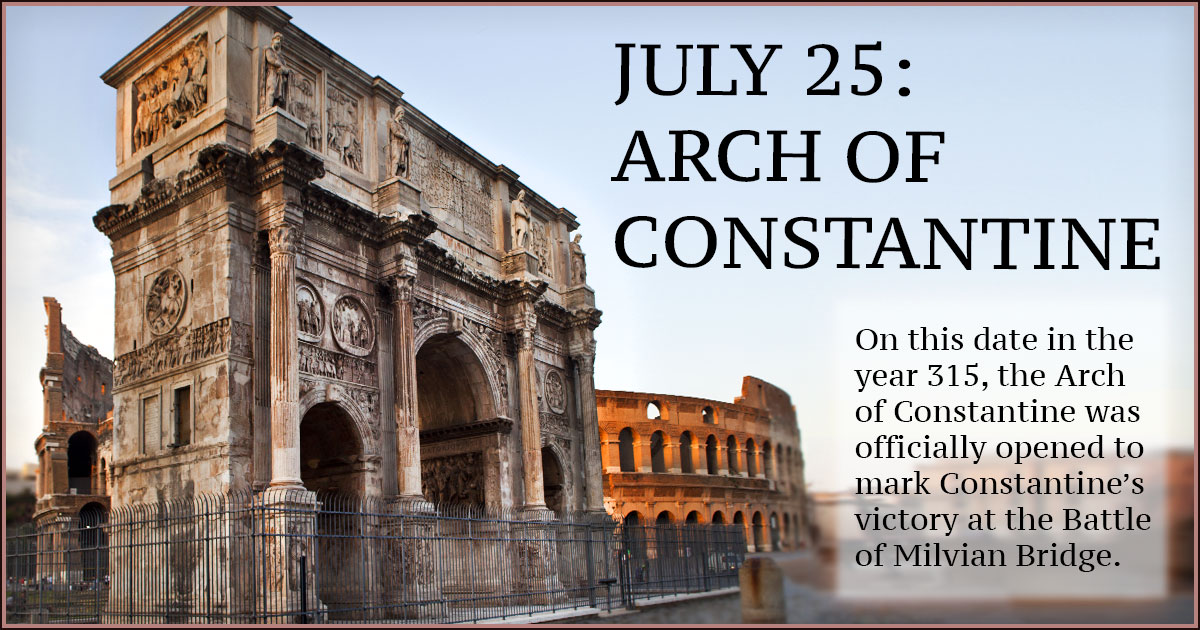
Watershed[edit]

The Jordan River Basin is in northern Utah.
Map of the entire Jordan River Basin


Jordan River
Proveau's Fork, West Jordan River
Jordan River Dam, 1908-01-28.jpg
Dam at Jordan River Narrows in 1901
Jordan River Utah with locator map.png
Map of the Jordan Subbasin and the location of Salt Lake County in Utah (inset)
Etymology Named after the Jordan River
Location
Country United States
State Utah
Counties UtahSalt Lake
Physical characteristics
Source Utah Lake
 • location Utah CountyUtah
 • coordinates 40°21′34″N 111°53′40″W[1]
 • elevation 4,489 ft (1,368 m)(compromise level)[2]
Mouth Great Salt Lake
 • location Davis CountyUtah
 • coordinates 40°53′52″N 111°58′25″W[1]
 • elevation 4,200 ft (1,300 m)(historical average)[3]
Length 51.4 mi (82.7 km)[4]
Basin size 791 sq mi (2,050 km2)[5]
Discharge  
 • location mouth
 • average 524 cu ft/s (14.8 m3/s)
Jordan River (Utah) - Wikipedia
Salt Lake City Map - EXPLAINED - YouTube
Jordan River Crossing into Promised Land, Baptismal Site of Jesus, Qsar al  Yahud | HolyLandSite.com
 
Pin on Travel
Why is the Dead Sea Called the Dead Sea?
How wide and deep was the Jordan River where Israel crossed? | NeverThirsty
Jordan River Parkway Trail | Utah Trails | TrailLink
 
Jordan River source, headwater, tel Dan Paneas, Caesarea philipi 1340 BC
Lot's Wife - A Pillar of Salt

Respuesta  Mensaje 1979 de 2006 en el tema 
De: BARILOCHENSE6999 Enviado: 10/06/2023 02:32
Resultado de imagen para SATURN ORION
Resultado de imagen para GIZE
Resultado de imagen para emmet brown frases
2017.05.13 - Pope Francis in Fatima - Holy Mass and canonization of Jacinta  and Francisco - YouTube
Lucia dos Santos | Biografía y visiones
Resultado de imagen de flower of life freemasonry
Image
7.3: Cúpula de Jerusalén de la Roca (691 CE) - LibreTexts Español
???? Como dibujar un OCTÓGONO a partir de un lado paso a paso ???? Dibujo  técnico - YouTube
Number 8 - Meaning - Symbolism - Fun Facts - in Religion and Myth
8-pointed Star Meaning: Octagram, The Star Of Lakshmi And Ishtar Symbolism  And Tattoo Ideas
ÉGLISE DE LA MADELEINE - 127 Photos & 39 Reviews - Place de la Madeleine,  Paris, France - Landmarks & Historical Buildings - Phone Number - Yelp
La Madeleine, París foto editorial. Imagen de maria, madeleina - 30180196
Temple Sainte Marie Paris Stock Photos - Free & Royalty-Free Stock Photos  from Dreamstime
Église de la Madeleine - Paris (English)
L'église de la Madeleine - Paris - revives the Classical Greek Temple model  (via Roman era temple) in the 19th century | Paris city, Paris france, Paris
Top 10 Facts About La Madeleine In Paris
✓ The Madeleine - Data, Photos & Plans - WikiArquitectura
 
France, Token, Touristic token, Paris - Eglise de la Madeleine n°2, 2013,  MDP
Monnaie de Paris Tourist Token - Paris (Eglise de la Madeleine) - France –  Numista
Monnaie de Paris Tourist Token - Paris (Eglise de la Madeleine - Le  Ravissement) - France – Numista
VISITE GUIDEE Autour de la Madeleine - Guide Conférencier | Visites guidées  à Paris : + de 50 visites culturelles à Paris par un guide conférencier
Sainte-Marie-Madeleine - Diocèse de Paris
19 fotos e imágenes de Léglise Sainte Marie Madeleine - Getty Images
How to get to Église de la Madeleine in Paris by Metro, Bus, Train or RER?
Histoire de l'Église & Sainte-Madeleine – Sainte Marie-Madeleine à Paris
EURion-Constellation
Jerusalem Temple Dome
Constelación EURión
 

Respuesta  Mensaje 1980 de 2006 en el tema 
De: BARILOCHENSE6999 Enviado: 10/06/2023 09:07


Respuesta  Mensaje 1981 de 2006 en el tema 
De: BARILOCHENSE6999 Enviado: 21/06/2023 00:12
RKT-963-LORRAINE - Silver Star Broach with Double Cross

Respuesta  Mensaje 1982 de 2006 en el tema 
De: BARILOCHENSE6999 Enviado: 21/06/2023 00:45
What were Jesus' mistakes? - Quora

Respuesta  Mensaje 14 de 21 en el tema 
De: BARILOCHENSE6999 Enviado: 20/06/2023 20:44
Cross Of Lorraine Knights Templar Flash Sales - www.cimeddigital.com  1687114090

Respuesta  Mensaje 15 de 21 en el tema 
De: BARILOCHENSE6999 Enviado: 20/06/2023 20:45
Cross of Lorraine - Origin and symbolism

Respuesta  Mensaje 16 de 21 en el tema 
De: BARILOCHENSE6999 Enviado: 20/06/2023 20:48
AD Cross of Lorraine, used by early Knights Templar Jerusalem Cross /  Emblem of the Knights Templar Tem Baby - iFunny Brazil

Respuesta  Mensaje 17 de 21 en el tema 
De: BARILOCHENSE6999 Enviado: 20/06/2023 20:49
RKT-963-LORRAINE - Silver Star Broach with Double Cross

Respuesta  Mensaje 18 de 21 en el tema 
De: BARILOCHENSE6999 Enviado: 20/06/2023 21:22
Fashion (R562-Gold-Black)Catholic Lorraine Cross Joan Of AStainless Steel  Mens Rings | Jumia Nigeria

Respuesta  Mensaje 19 de 21 en el tema 
De: BARILOCHENSE6999 Enviado: 20/06/2023 21:27
Cross Of Lorraine Freemasonry Online - www.cimeddigital.com 1686376511

Respuesta  Mensaje 20 de 21 en el tema 
De: BARILOCHENSE6999 Enviado: 20/06/2023 21:39
Amazon.com: Freemason Masonic York Rite Deluxe Large Knights Templar  Freemasonry 1 1/4" Lapel Pin : ביגוד, נעליים ותכשיטים

Respuesta  Mensaje 21 de 21 en el tema 
De: BARILOCHENSE6999 Enviado: 20/06/2023 21:43
Who did you have a bigger crush on watching the Back to the Future movies -  Marty's girlfriend Jennifer or his mom Lorraine? Note: There were two  Jennifers. : r/movies

Respuesta  Mensaje 1983 de 2006 en el tema 
De: BARILOCHENSE6999 Enviado: 06/07/2023 03:03
Kronos. La puerta del tiempo: El arma más poderosa del III Reich. (Versión  sin solapas): El Arma Mas Secreta del III Reich (Narrativa) : Botaya, Felipe:  Amazon.es: Libros

Respuesta  Mensaje 1984 de 2006 en el tema 
De: BARILOCHENSE6999 Enviado: 07/12/2023 20:39


Respuesta  Mensaje 1985 de 2006 en el tema 
De: BARILOCHENSE6999 Enviado: 08/12/2023 14:02


Respuesta  Mensaje 1986 de 2006 en el tema 
De: BARILOCHENSE6999 Enviado: 27/12/2023 02:37

Arch of Constantine


From Wikipedia, the free encyclopedia
 
Arch of Constantine
Arch of Constantine
Arch of Constantine is located in Rome
Arch of Constantine
Arch of Constantine
Shown within Augustan Rome
Map
Click on the map for a fullscreen view
Location Regio X Palatium
Coordinates 41°53′23″N 12°29′27″E
Type Triumphal arch
History
Builder Constantine I
Founded AD 315

The Arch of Constantine (ItalianArco di Costantino) is a triumphal arch in Rome dedicated to the emperor Constantine the Great. The arch was commissioned by the Roman Senate to commemorate Constantine's victory over Maxentius at the Battle of Milvian Bridge in AD 312. Situated between the Colosseum and the Palatine Hill, the arch spans the Via Triumphalis, the route taken by victorious military leaders when they entered the city in a triumphal procession. [a] Dedicated in 315, it is the largest Roman triumphal arch, with overall dimensions of 21 m (69 ft) high, 25.9 m (85 ft) wide and 7.4 m (24 ft) deep.[1] It has three bays, the central one being 11.5 m (38 ft) high and 6.5 m (21 ft) wide and the laterals 7.4 m (24 ft) by 3.4 m (11 ft) each. The arch is constructed of brick-faced concrete covered in marble.

The three bay design with detached columns was first used for the Arch of Septimius Severus in the Roman Forum (which stands at the end of the triumph route) and repeated in several other arches now lost.

Though dedicated to Constantine, much of the sculptural decoration consists of reliefs and statues removed from earlier triumphal monuments dedicated to Trajan (98–117), Hadrian (117–138) and Marcus Aurelius (161–180), with the portrait heads replaced with his own.[2]

History[edit]

The arch, which was constructed between 312 and 315, was dedicated by the Senate to commemorate ten years (a decennia[b]) of Constantine's reign (306–337) and his victory over the then reigning emperor Maxentius (306–312) at the Battle of Milvian Bridge on 28 October 312,[4] as described on its attic inscription,[5] and officially opened on 25 July 315. Not only did the Roman senate give the arch for Constantine's victory, they also were celebrating decennalia: a series of games that happened every decade during the Roman Empire. On these occasions they also said many prayers and renewed both spiritual and mundane vows.[6] However, Constantine had actually entered Rome on 29 October 312, amidst great rejoicing, and the Senate then commissioned the monument.[7] Constantine then left Rome within two months and did not return until 326.[8]

The Arch of Constantine, Rome - painted by Herman van Swanevelt, 17th century

The location, between the Palatine Hill and the Caelian Hill, spanned the ancient route of Roman triumphs (Via triumphalis) at its origin, where it diverged from the Via sacra.[4][9][10] This route was that taken by the emperors when they entered the city in triumph. This route started at the Campus Martius, led through the Circus Maximus, and around the Palatine Hill; immediately after the Arch of Constantine, the procession would turn left at the Meta Sudans and march along the Via sacra to the Forum Romanum and on to the Capitoline Hill, passing through both the Arches of Titus and Septimius Severus.

During the Middle Ages, the Arch of Constantine was incorporated into one of the family strongholds of ancient Rome, as shown in the painting by Herman van Swanevelt, here. Works of restoration were first carried out in the 18th century,[11][c] the last excavations have taken place in the late 1990s, just before the Great Jubilee of 2000. The arch served as the finish line for the marathon athletic event for the 1960 Summer Olympics.


Respuesta  Mensaje 1987 de 2006 en el tema 
De: BARILOCHENSE6999 Enviado: 27/12/2023 03:06
Resultado de imagen para 25 de julio santiago de compostela

Arch of Constantine


From Wikipedia, the free encyclopedia
 
Arch of Constantine
Arch of Constantine
Arch of Constantine is located in Rome
Arch of Constantine
Arch of Constantine
Shown within Augustan Rome
Map
Click on the map for a fullscreen view
Location Regio X Palatium
Coordinates 41°53′23″N 12°29′27″E
Type Triumphal arch
History
Builder Constantine I
Founded AD 315

The Arch of Constantine (ItalianArco di Costantino) is a triumphal arch in Rome dedicated to the emperor Constantine the Great. The arch was commissioned by the Roman Senate to commemorate Constantine's victory over Maxentius at the Battle of Milvian Bridge in AD 312. Situated between the Colosseum and the Palatine Hill, the arch spans the Via Triumphalis, the route taken by victorious military leaders when they entered the city in a triumphal procession. [a] Dedicated in 315, it is the largest Roman triumphal arch, with overall dimensions of 21 m (69 ft) high, 25.9 m (85 ft) wide and 7.4 m (24 ft) deep.[1] It has three bays, the central one being 11.5 m (38 ft) high and 6.5 m (21 ft) wide and the laterals 7.4 m (24 ft) by 3.4 m (11 ft) each. The arch is constructed of brick-faced concrete covered in marble.

The three bay design with detached columns was first used for the Arch of Septimius Severus in the Roman Forum (which stands at the end of the triumph route) and repeated in several other arches now lost.

Though dedicated to Constantine, much of the sculptural decoration consists of reliefs and statues removed from earlier triumphal monuments dedicated to Trajan (98–117), Hadrian (117–138) and Marcus Aurelius (161–180), with the portrait heads replaced with his own.[2]

History[edit]

The arch, which was constructed between 312 and 315, was dedicated by the Senate to commemorate ten years (a decennia[b]) of Constantine's reign (306–337) and his victory over the then reigning emperor Maxentius (306–312) at the Battle of Milvian Bridge on 28 October 312,[4] as described on its attic inscription,[5] and officially opened on 25 July 315. Not only did the Roman senate give the arch for Constantine's victory, they also were celebrating decennalia: a series of games that happened every decade during the Roman Empire. On these occasions they also said many prayers and renewed both spiritual and mundane vows.[6] However, Constantine had actually entered Rome on 29 October 312, amidst great rejoicing, and the Senate then commissioned the monument.[7] Constantine then left Rome within two months and did not return until 326.[8]

The Arch of Constantine, Rome - painted by Herman van Swanevelt, 17th century

The location, between the Palatine Hill and the Caelian Hill, spanned the ancient route of Roman triumphs (Via triumphalis) at its origin, where it diverged from the Via sacra.[4][9][10] This route was that taken by the emperors when they entered the city in triumph. This route started at the Campus Martius, led through the Circus Maximus, and around the Palatine Hill; immediately after the Arch of Constantine, the procession would turn left at the Meta Sudans and march along the Via sacra to the Forum Romanum and on to the Capitoline Hill, passing through both the Arches of Titus and Septimius Severus.

During the Middle Ages, the Arch of Constantine was incorporated into one of the family strongholds of ancient Rome, as shown in the painting by Herman van Swanevelt, here. Works of restoration were first carried out in the 18th century,[11][c] the last excavations have taken place in the late 1990s, just before the Great Jubilee of 2000. The arch served as the finish line for the marathon athletic event for the 1960 Summer Olympics.


Respuesta  Mensaje 1988 de 2006 en el tema 
De: BARILOCHENSE6999 Enviado: 27/12/2023 03:44
July 25: Arch of Constantine | FCIT

Respuesta  Mensaje 1989 de 2006 en el tema 
De: BARILOCHENSE6999 Enviado: 09/01/2024 03:44
July 25: Arch of Constantine | FCIT

Respuesta  Mensaje 1990 de 2006 en el tema 
De: BARILOCHENSE6999 Enviado: 17/01/2024 13:27


Respuesta  Mensaje 1991 de 2006 en el tema 
De: BARILOCHENSE6999 Enviado: 20/01/2024 01:00


Primer  Anterior  1977 a 1991 de 2006  Siguiente   Último 
Tema anterior  Tema siguiente
 
©2024 - Gabitos - Todos los derechos reservados