|
|
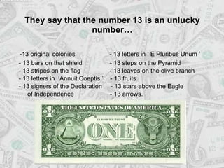
General: LAS PROFECIAS DE DANIEL ESTAN EN FUNCION AL DIA DE MARIA MAGDALENA (HECHOS 7:22)
Triar un altre plafó de missatges |
|
|
Observational Hebrew Year of Moses
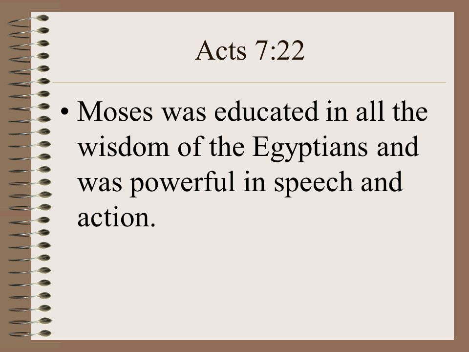
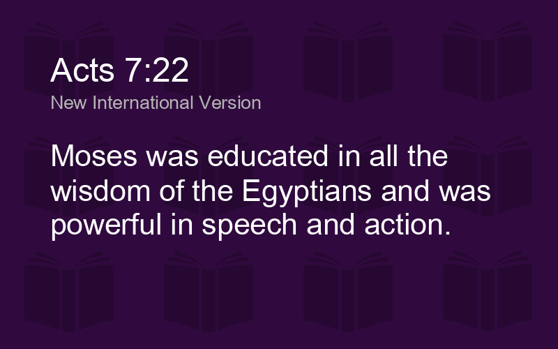
- 1. Equinox (interval 365.2422 days) by Solar Alignment Observation God, through Moses, ordained the first month of the Jewish calendar year to start in spring. Many writers consider the date of this first month start as a great mystery. The Hebrew word for 'month' and 'new moon' are interchangeable and translated by context. Each new moon was to be celebrated by trumpets; Nu10:10, Ps81:3, 2Ch2:4. This was practiced from Moses, at least thru the time of Paul's epistles, Col2:16. The ancient means to select when the 1st month of each new year started has been avidly discussed by many writers. This month shall be unto you the beginning of months: it shall be the first month of the year to you.... keep this ordinance in ITS SEASON from year to year, Ex12:2,13:10 . And Moses was learned in ALL the wisdom of the Egyptians... Acts 7:22 Indeed it is a mystery, if the ancient‟s time keeping method of simple alignment is not understood. Much ink has been used talking of the Barley harvest. OBSERVATIONAL HEBREW YEAR OF MOSES by O.P. Armstrong July - 2016 1
- 2. OBSERVATIONAL HEBREW YEAR OF MOSES by O.P. Armstrong July - 2016 But finding the first solar month could be accomplished from the Temple Mount by watching where the sunrise happened in east upon Mount Olivet. This is illustrated in the prior picture. Another method is to use a gnomon or obelisk. This was widely employed by the Egyptian culture to find time, direction and seasons. The method is illustrated by the attached pictures. During desert travels, after the Exodus, the tabernacle was to be erected with principle ordinates. 2 The ordinates were easily obtained by use of a gnomon, that could also serve to mark the spring equinox. “for the south side.... And for the second side of the tabernacle on the north side there shall be twenty boards.. tabernacle, westward..” Ex26:18-27. For the Christian era, this importance is two fold. First is to know that a bible year is a solar year. Use a BAY To improve shadow definition Second is in keeping Church Calendar. For that calendar is set by Easter and it shall be the 1st Sunday following the 1st Full Moon after the Spring or Vernal Equinox of each year.
- 3. Great OBSERVATIONAL HEBREW YEAR OF MOSES by O.P. Armstrong July - 2016 The Mosaic holidays revolved around spring and autumn. Three main holidays were given by Moses. First was Passover, with main dates on 10th and 14th day of first month. Next was Pentecost, Lev23:16, Count fifty days to the day after the seventh Sabbath; then you shall offer.... The last as: „In the seventh month, on the first day of the month, you shall have a Sabbath-rest, a memorial of blowing of trumpets... Lev23:24. Marking years were mandated by the Sabbath or 7th year and Jubilee or 50th year. The Sothic calendar system (365 days, circa 3,000BC) started at Heliacal rising of Sirius upon Summer Solstice, June20 +/- . They Intercalated the last days of a year. The current rabbinical calendar, has 365.2468days/Year. Only the 1st to 7th months were critical to the ancient Hebrew calendar. The time after the 12th month unto the start of the next year new month could be counted as intercalated days, with an ignored month, if only interested in months 1 to 7. The Egyptian culture (of Moses time) used such methods as illustrated by the Pyramid alignments on principle ordinates. Many other ancient cultures also used monument markers to mark the four seasons, spring, summer, autumn, and winter. 3 Sphinx South EAST Khufu Great North
- 4. OBSERVATIONAL HEBREW YEAR OF MOSES by O.P. Armstrong July - 2016 4 Another way is to make an extra long 12th month. No where in bible is mention of a 13th month, hence Adar2. But these leap months are required for a lunisolar calendar. A new year should start in first lunar month where the 14th lunar day falls on or after the spring equinox. This makes "days per year cycles" of 353/355 and 383/385 days. About every 3rd year will be a leap year of about 384 days. Counting of these days fall into 3 methods. Strictly observational says watch for the time of equinox, then look for the new moon. The length of lunar cycle (29/30 days) and of solar year (365 days) are well known. Thus by these facts an end of year calculation can be made for when to declare the first new moon of the new year. Finally there is the molad method of the rabbinical calendar, 365.2468day/Year, vs. Gregorian of 365.2425 d/Y. Bible Basis of 12 Months: 1Kgs4:7 “... twelve officers over all Israel... each man his month in a year...” 1Ch27, 12months1year, “all the months of the year...The twelfth captain for the twelfth month.” The sacred duties were divided into 24 groups, this suggests rotation of a group every 2 weeks. Twelfth month: had at least 27 days as seen by 2Kg25:27, it was given the name of Adar, see Est3:7&13,8:12,9:1. Here an eleventh month of 29 days is found by inclusive count, Neh6:15, 52 less 25 days equal 27 plus the start stop days of 2 gives 29 days. Also in story of Noah are found 5 months of 30 days each, Gen7:11,24 & 8:3-4. This indicates bible months are lunar months. For the lunar month must alternate 29 and 30 days to match the 29.5 days of average lunar period. Khufu Sphinx Equinox Sunset Alignment at Giza Looking due West w E NS
- 5. OBSERVATIONAL HEBREW YEAR OF MOSES by O.P. Armstrong July - 2016 5 Marking time by equinox of the two seasons has the least long term jitter. Long term Jitter is caused by earth polar precession, as demonstrated by below graphic. Moses used the most stable year start marker. Refs: https://www.fourmilab.ch/earthview/pacalc.html http://judaicseminar.org/halakhot/calendar_jewish.htm https://www.fourmilab.ch/documents/calendar/ http://www.knowth.com/loughcrew.htm https://stellafane.org/misc/equinox.html http://www.lavia.org/english/archivo/egyptiancalendaren. html http://www.michaelsheiser.com/PaleoBabble/IslerMethod OfFindingExtendingDirection.pdf Only at equinoxes does sun rise due east and set due west. Stonehenge is one of many known archeoastronomy sites. It was used to mark seasons. Researcher J. Q. Jacobs has documented these sites extensively.
- 6. OBSERVATIONAL HEBREW YEAR OF MOSES by O.P. Armstrong July - 2016 Marking Years by Astronomical Moments of Equinox and New Moon. The first new moon of each new year is selected so the 14th day (full moon) must fall on or after the Spring Equinox. This causes the lunar months to cycle in a progression of 400 Years of 12 lunar months to about 233 years of 13 lunar months. By using observation, the years of 12 and 13 moons will be automatically selected from the determination rule. Over increasing intervals (19,38,190,391) the average length of a year will trend towards 365.2422 days. This is demonstrated by graph above. 6
- 7. OBSERVATIONAL HEBREW YEAR OF MOSES by O.P. Armstrong July - 2016 7 Equinox Sunrise at Giza Egyptian tools at time of Moses EastWest North
- 8. OBSERVATIONAL HEBREW YEAR OF MOSES by O.P. Armstrong July - 2016 Without Equinox Sunset With Equinox Sunset W E N 8 The Solar Lunar cycles are times periods that give repeating calendar cycles. The older cycles are the Saros, (18 Year) and Metonic, 19Y. Some other whole year cycles are Half Sar, 9Yr, Unidos, 65Y, 176Y, 298Y. Longer Cycles are Trihex, 195Y, Hipparchus, 345Y, Gregorian1, 353Y, Gregoriana 372Y, Hexdodea 390Y, Grattan Guinness 391Y, Gregorian2, 725Y, 1042Y.Any multiple of smaller cycles can be tried, like double basic 1042Y. Meton's cycle of 19 years harmonizes the solar year (19 solar years) with the lunar month (235 lunar months) with a remainder of about 2 hours and 3 minutes by which the solar year finishes earlier than the lunar. Another cycle is 190 or 10 Metons. M. de Cheseaux's cycle of 315 years harmonizes the solar and lunar years within 3 hours and 24 minutes. The Metonic 19-year cycle gets rid of most of it's remainder in a larger Biblical cycle of 2,300 years, Dan8:14. Cheseaux's cycle, 315 years, is one quarter of a larger Biblical cycle of 1,260 years (Dan. 8:12; 12:7; Rev. 12:6,14) which is ten times more accurate than Meton's cycle. After 1260 years the sun and moon return, within less than half a degree, to the same point of the ecliptic precisely, and that within an hour of each other. If we subtract 1260 from 2300 we get 1040 which is the long- awaited solar-lunar cycle that harmonizes all three measurements: the year, month and day "with an almost imperceptible error" (Error is .11 of a day, Parker's Celestial Cycles, p.22). In fact, this 1040 year "Daniel Cycle" reaches an error of one day in 15,056 years. Every 687 years the sun and the moon come back into the same relative positions to within 43 minutes. In 1906, Dr. W. Bell Dawson discovered that the average of 2300 and 1260 lunar years, or 1780 lunar years, was almost exactly equal to 1727 solar years, giving a cycle of even higher accuracy than the 1040 "Daniel Cycle." The most accurate anomalistic cycle (the time it takes for the moon to return to the corresponding point on its elliptical orbit), viz. 1336, is the difference between 1727 and 391. (see Soli-Lunar Cycles In Greek Research and Jewish Revelation by Walter S. Ridgway, UBC, 1946). Without Equinox Sunset Meridian Alignments
- 9. OBSERVATIONAL HEBREW YEAR OF MOSES by O.P. Armstrong July - 2016 9 The Gnomon or Obelisk is an astronomical measurement device. The solar alignments are the main aspect to determine seasons. This is possible because of the orbital layout. These facts are shown here in theory and in practice. Omitted here but given earlier is the BAY tool to improve shadow definition. Without that Egyptian tool, the accuracy is decreased as suggested by some. In church times these are used in order to better calculate the astronomical event of EASTER. See next slide.
- 10. OBSERVATIONAL HEBREW YEAR OF MOSES by O.P. Armstrong July - 2016 10 The Gnomon of Saint- Sulpice is an astronomical measurement device located in the Church of Saint-Sulpice (Église Saint- Sulpice) in Paris, France. It is a gnomon, a device designed to cast a shadow on the ground in order to determine the position of the sun in the sky. In early modern times, other gnomons were also built in several Italian and French churches in order to better calculate the astronomical event of EASTER.
- 11. OBSERVATIONAL HEBREW YEAR OF MOSES by O.P. Armstrong July - 2016 11 Cambodia, Angkor Wat On the morning of the spring equinox, the sun rises up the side of the central tower of the temple and crowns its pinnacle. El Castillo, Mexico One of the most famous ancient spring equinox celebrations was the Mayan pyramid in Chichen Itza, Mexico. The pyramid, also known as El Castillo, has four staircases running from the top to the bottom of the pyramid's faces. The staircases were built at a carefully calculated angle so that at the precise moment of the equinox and for a period of about half an hour, a snake of sunlight appears to slither down the stairs. The Kukulkan appears twice a year, on the spring and autumn equinox, when day and night, light and dark, are equal and in balance.
- 12. OBSERVATIONAL HEBREW YEAR OF MOSES by O.P. Armstrong July - 2016 The Wagon Wheel of Native American plains Indians have summer solstice and other alignments. One is located Between Cody and Lovell Wyoming. It is called Big Horn Medicine Wheel. In the 4 Corners area exist solar monuments left by Anasia tribes. Shown to the left is the sun dagger design at Fajada Butte in Chaco Culture National Historical Park. Many other monuments like Pinson mounds West Tenn., Mounds at Earle & Scott Arkansas and the Henges of Ireland & UK show how ancient peoples accurately tracked the seasons by observation without calculators and equations. 12
- https://es.slideshare.net/OtisArmstrong/observational-hebrew-year-of-moses

|
|
|
|
|
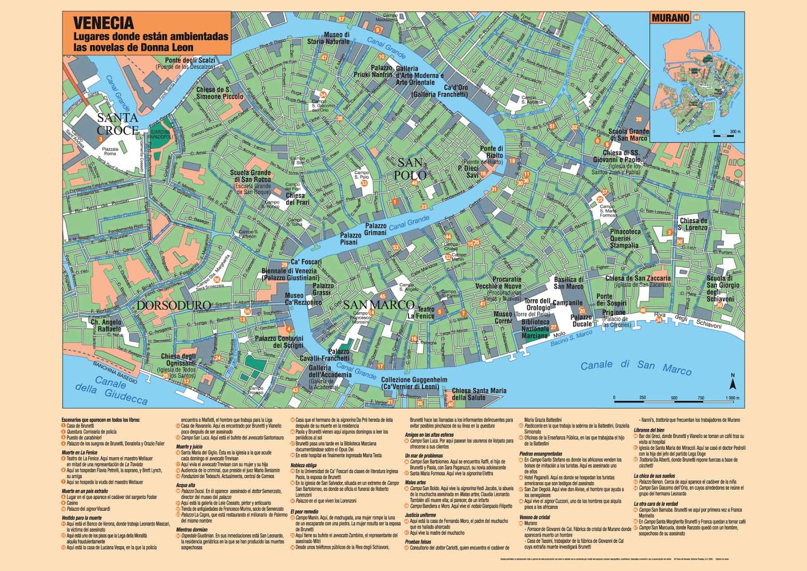
ISLA SAN GIORGIO (VENECIA)=GEORGE LEMAITRE

BABILONIA LA RAMERA ES UNA MUJER Y ES LA MISMA BESTIA
ESTA EN LA GRAFICA

https://www.kienyke.com/historias/enigmatico-viajar-en-el-tiempo-cuantico
8 ene. 2018 - ... Kurt Gödel un brillante matemático amigo de Einstein, sugirió que para ir al pasado era necesario desdoblar el tiempo a través de un atajo y llegar a cualquier parte antes que la luz. Basados en esta hipótesis, algunos físicos cuánticos de la actualidad descubrieron que los agujeros de gusanos pueden ...
https://matap.dmae.upm.es/cienciaficcion/narraciones/.../agujerosdegusano.htm
Entre éstas se destacan el cilindro de longitud infinita y compuesto de polvo en rotación rápida de Van Stockum, y el universo en rotación propuesto por Kurt Gödel. La matemática de estas soluciones muestra que ambas contienen trayectorias en el espacio-tiempo que permiten viajar hacia el pasado y retornar al ...
www.aecomunicacioncientifica.org/que-dice-la-fisica-sobre-los-viajes-en-el-tiempo/
5 may. 2016 - El viaje se realizaría a través de un wormhole (literalmente, un agujero de gusano), un túnel a través del espacio-tiempo. ... Para terminar, citaré que el famoso matemático Kurt Gödelpropuso en 1949 un modelo cosmológico compatible con la relatividad general, en el que los viajes en el tiempo serían ...
https://books.google.com.ar/books?isbn=6073137427
Kurt Gödel 1 y Kip Thorne2 han demostrado que los agujeros de gusano podrían engendrar unos nudos temporales, unos pasajes del presente hacia el pasado. Así se vuelven verdaderas máquinas para pasear por el tiempo pasado. Si la entrada del agujero de gusano (el agujero negro) es inmóvil en relación con ...
www.lehman.edu/faculty/anchordoqui/tuneles2.htm
Entre estas se destacan el cilindro de longitud infinita y compuesto de polvo en rotación rápida de Van Stockum, y el universo en rotación propuesto por Kurt Gödel. ... Supongamos (figura 3) que existe unagujero de gusano atravesable cuyas bocas, separadas por una distancia mucho mayor que el radio de su garganta, ...
blogs.publico.es/kaostica/2014/11/06/interstellar/
6 nov. 2014 - Antes de adentrarnos en los agujeros de gusano, es preciso entender qué son los agujeros negros y, sobre todo, los menos conocidos agujeros blancos. ... En 1949, Kurt Gödel, buen amigo de Albert Einstein, planteó un modelo cosmológico para un universo en rotación consistente con la Relatividad ...
https://books.google.com.ar/books?isbn=8483230755
Yervant Terzian (ed.), Elizabeth Bilson (ed.) - 1999 - Science
En el lado del agujero de gusano que ocupa Carolee es domingo (aunque solo haya envejecido una hora hasta llegar a este punto). ... gran matemático Kurt Gódel (1949), el universo aparece girando a alta velocidad y dotado de una constante cosmológica, con lo que se convierte en una máquina gigantesca del tiempo.
historiadeltiempo-edgardo.blogspot.com/.../capitulo-10-agujeros-de-gusano-y-viajes.h...
5 may. 2011 - viajes en el tiempo se produjo en 1949 cuando Kurt Gödel descubrió un nuevo. espacio-tiempo permitido por la teoría de la relatividad. Gödel fue un matemático. que se hizo famoso al demostrar que es imposible probar todas las afirmaciones. verdaderas, incluso si nos limitáramos a tratar de probar las ...
 
|
|
|
|
|
|
|
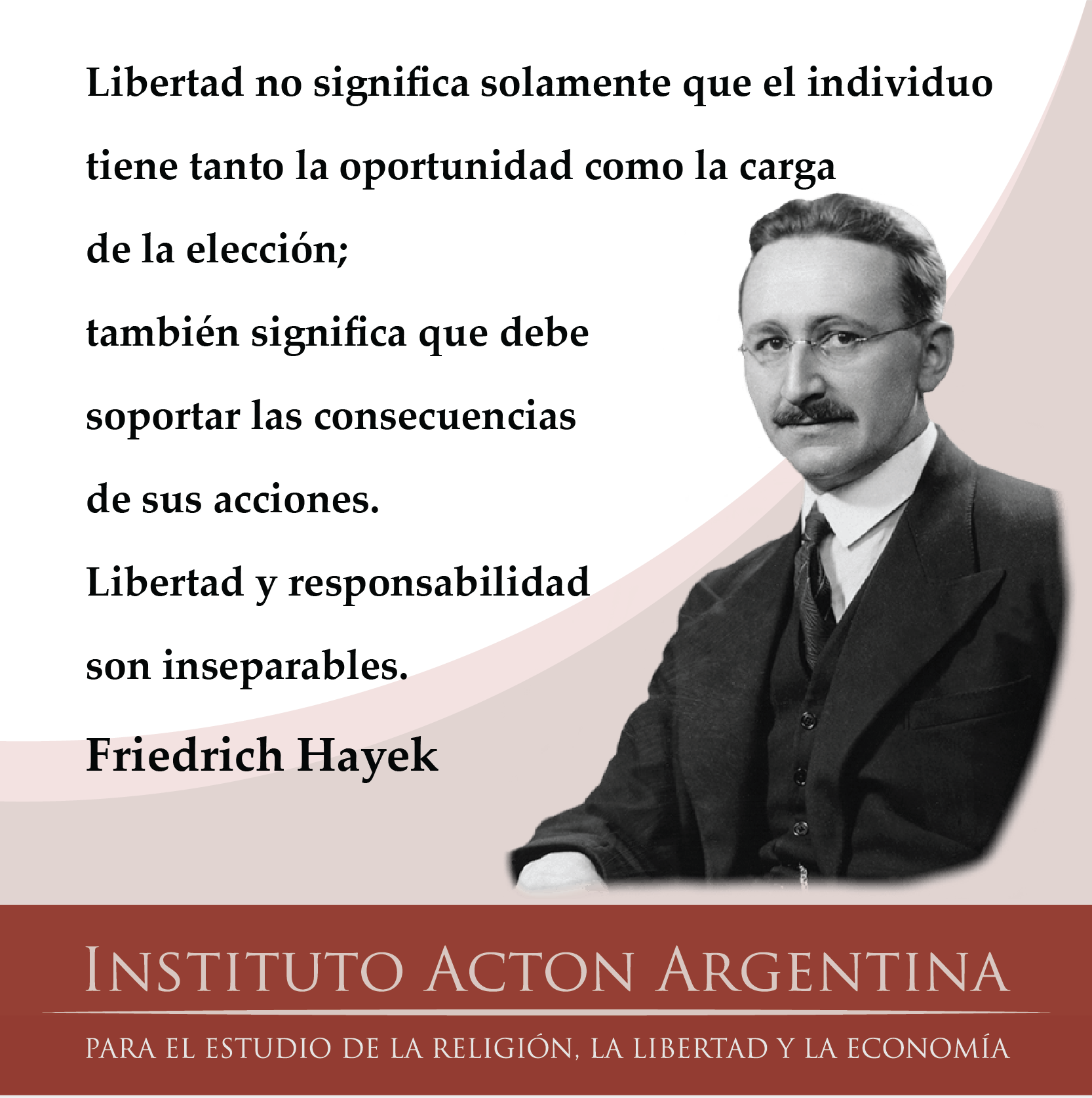
El libre albedrío es la libre elección..
Basada en la propia decisión...
Esto es lo que profesa la filosofía humana..
Afirmando que el libre albedrio está basado..
En la propia ética o en la propia conciencia..
Pero realmente el libre albedrio..
Es la determinación carnal..
Acerca del bien y el mal..
En el cristianismo el libre albedrio vendría siendo..
El Espíritu Santo que nos arguye en el bien..
Porque la obra del Señor es tendiente sólo al bien..
Entonces los cristianos somos verdaderamente libres..
No somos parte de las engañosas filosofías..
El Ungido |
|
|
|
|
|
 the Apple
|
|
|
|
|

Jordan River (Utah)
From Wikipedia, the free encyclopedia
The Jordan River, in the state of Utah, United States, is a river about 51 miles (82 km) long. Regulated by pumps at its headwaters at Utah Lake, it flows northward through the Salt Lake Valley and empties into the Great Salt Lake. Four of Utah's six largest cities border the river: Salt Lake City, West Valley City, West Jordan, and Sandy. More than a million people live in the Jordan Subbasin, part of the Jordan River watershed that lies within Salt Lake and Utah counties. During the Pleistocene, the area was part of Lake Bonneville.
Members of the Desert Archaic Culture were the earliest known inhabitants of the region; an archaeological site found along the river dates back 3,000 years. Mormon pioneers led by Brigham Young were the first European American settlers, arriving in July 1847 and establishing farms and settlements along the river and its tributaries. The growing population, needing water for drinking, irrigation, and industrial use in an arid climate, dug ditches and canals, built dams, and installed pumps to create a highly regulated river.
Although the Jordan was originally a cold-water fishery with 13 native species, including Bonneville cutthroat trout, it has become a warm-water fishery where the common carp is most abundant. It was heavily polluted for many years by raw sewage, agricultural runoff, and mining wastes. In the 1960s, sewage treatment removed many pollutants. In the 21st century, pollution is further limited by the Clean Water Act, and, in some cases, the Superfund program. Once the home of bighorn sheep and beaver, the contemporary river is frequented by raccoons, red foxes, and domestic pets. It is an important avian resource, as are the Great Salt Lake and Utah Lake, visited by more than 200 bird species.
Big Cottonwood, Little Cottonwood, Red Butte, Mill, Parley's, and City creeks, as well as smaller streams like Willow Creek at Draper, Utah, flow through the sub-basin. The Jordan River Parkway along the river includes natural areas, botanical gardens, golf courses, and a 40-mile (64 km) bicycle and pedestrian trail, completed in 2017.[6]
The Jordan River is Utah Lake's only outflow. It originates at the northern end of the lake between the cities of Lehi and Saratoga Springs. It then meanders north through the north end of Utah Valley for approximately 8 miles (13 km) until it passes through a gorge in the Traverse Mountains, known as the Jordan Narrows. The Utah National Guard base at Camp Williams lies on the western side of the river through much of the Jordan Narrows.[7][8] The Turner Dam, located 41.8 miles (67.3 km) from the river's mouth (or at river mile 41.8) and within the boundaries of the Jordan Narrows, is the first of two dams of the Jordan River. Turner Dam diverts the water to the right or easterly into the East Jordan Canal and to the left or westerly toward the Utah and Salt Lake Canal. Two pumping stations situated next to Turner Dam divert water to the west into the Provo Reservoir Canal, Utah Lake Distribution Canal, and Jacob-Welby Canal. The Provo Reservoir Canal runs north through Salt Lake County, Jacob-Welby runs south through Utah County. The Utah Lake Distribution Canal runs both north and south, eventually leading back into Utah Lake.[9] Outside the narrows, the river reaches the second dam, known as Joint Dam, which is 39.9 miles (64.2 km) from the river's mouth. Joint Dam diverts water to the east for the Jordan and Salt Lake City Canal and to the west for the South Jordan Canal.[10][11][12]

Map of the Salt Lake Valley
The river then flows through the middle of the Salt Lake Valley, initially moving through the city of Bluffdale and then forming the border between the cities of Riverton and Draper.[7] The river then enters the city of South Jordan where it merges with Midas Creek from the west. Upon leaving South Jordan, the river forms the border between the cities of West Jordan on the west and Sandy and Midvale on the east. From the west, Bingham Creek enters West Jordan. Dry Creek, an eastern tributary, combines with the main river in Sandy. The river then forms the border between the cities of Taylorsville and West Valley City on the west and Murray and South Salt Lake on the east. The river flows underneath Interstate 215 in Murray. Little and Big Cottonwood Creeks enter from the east in Murray, 21.7 miles (34.9 km) and 20.6 miles (33.2 km) from the mouth respectively. Mill Creek enters on the east in South Salt Lake, 17.3 miles (27.8 km) from the mouth. The river runs through the middle of Salt Lake City, where the river travels underneath Interstate 80 a mile west of downtown Salt Lake City and again underneath Interstate 215 in the northern portion of Salt Lake City. Interstate 15 parallels the river's eastern flank throughout Salt Lake County. At 16 miles (26 km) from the mouth, the river enters the Surplus Canal channel. The Jordan River physically diverts from the Surplus Canal through four gates and heads north with the Surplus Canal heading northwest. Parley's, Emigration, and Red Butte Creeks converge from the east through an underground pipe, 14.2 miles (22.9 km) from the mouth.[7] City Creek also enters via an underground pipe, 11.5 miles (18.5 km) from the river's mouth. The length of the river and the elevation of its mouth varies year to year depending on the fluctuations of the Great Salt Lake caused by weather conditions. The lake has an average elevation of 4,200 feet (1,300 m) which can deviate by 10 feet (3.0 m).[3] The Jordan River then continues for 9 to 12 miles (14 to 19 km) with Salt Lake County on the west and North Salt Lake and Davis County on the east until it empties into the Great Salt Lake.[7][8][11]
Discharge[edit]
The United States Geological Survey maintains a stream gauge in Salt Lake City that shows annual runoff from the period 1980–2003 is just over 150,000 acre-feet (190,000,000 m3) per year or 100 percent of the total 800,000 acre-feet (990,000,000 m3) of water entering the Jordan River from all sources. The Surplus Canal carries almost 60 percent of the water into the Great Salt Lake, with various irrigation canals responsible for the rest. The amount of water entering the Jordan River from Utah Lake is just over 400,000 acre-feet (490,000,000 m3) per year. Inflow from the 11 largest streams feeding the Jordan River, sewage treatment plants, and groundwater each account for approximately 15 percent of water entering the river.[13]
Watershed[edit]

Map of the entire Jordan River Basin
|
|
|
|
|
Jordan River (Utah)
From Wikipedia, the free encyclopedia
The Jordan River, in the state of Utah, United States, is a river about 51 miles (82 km) long. Regulated by pumps at its headwaters at Utah Lake, it flows northward through the Salt Lake Valley and empties into the Great Salt Lake. Four of Utah's six largest cities border the river: Salt Lake City, West Valley City, West Jordan, and Sandy. More than a million people live in the Jordan Subbasin, part of the Jordan River watershed that lies within Salt Lake and Utah counties. During the Pleistocene, the area was part of Lake Bonneville.
Members of the Desert Archaic Culture were the earliest known inhabitants of the region; an archaeological site found along the river dates back 3,000 years. Mormon pioneers led by Brigham Young were the first European American settlers, arriving in July 1847 and establishing farms and settlements along the river and its tributaries. The growing population, needing water for drinking, irrigation, and industrial use in an arid climate, dug ditches and canals, built dams, and installed pumps to create a highly regulated river.
Although the Jordan was originally a cold-water fishery with 13 native species, including Bonneville cutthroat trout, it has become a warm-water fishery where the common carp is most abundant. It was heavily polluted for many years by raw sewage, agricultural runoff, and mining wastes. In the 1960s, sewage treatment removed many pollutants. In the 21st century, pollution is further limited by the Clean Water Act, and, in some cases, the Superfund program. Once the home of bighorn sheep and beaver, the contemporary river is frequented by raccoons, red foxes, and domestic pets. It is an important avian resource, as are the Great Salt Lake and Utah Lake, visited by more than 200 bird species.
Big Cottonwood, Little Cottonwood, Red Butte, Mill, Parley's, and City creeks, as well as smaller streams like Willow Creek at Draper, Utah, flow through the sub-basin. The Jordan River Parkway along the river includes natural areas, botanical gardens, golf courses, and a 40-mile (64 km) bicycle and pedestrian trail, completed in 2017.[6]
The Jordan River is Utah Lake's only outflow. It originates at the northern end of the lake between the cities of Lehi and Saratoga Springs. It then meanders north through the north end of Utah Valley for approximately 8 miles (13 km) until it passes through a gorge in the Traverse Mountains, known as the Jordan Narrows. The Utah National Guard base at Camp Williams lies on the western side of the river through much of the Jordan Narrows.[7][8] The Turner Dam, located 41.8 miles (67.3 km) from the river's mouth (or at river mile 41.8) and within the boundaries of the Jordan Narrows, is the first of two dams of the Jordan River. Turner Dam diverts the water to the right or easterly into the East Jordan Canal and to the left or westerly toward the Utah and Salt Lake Canal. Two pumping stations situated next to Turner Dam divert water to the west into the Provo Reservoir Canal, Utah Lake Distribution Canal, and Jacob-Welby Canal. The Provo Reservoir Canal runs north through Salt Lake County, Jacob-Welby runs south through Utah County. The Utah Lake Distribution Canal runs both north and south, eventually leading back into Utah Lake.[9] Outside the narrows, the river reaches the second dam, known as Joint Dam, which is 39.9 miles (64.2 km) from the river's mouth. Joint Dam diverts water to the east for the Jordan and Salt Lake City Canal and to the west for the South Jordan Canal.[10][11][12]
Map of the Salt Lake Valley
The river then flows through the middle of the Salt Lake Valley, initially moving through the city of Bluffdale and then forming the border between the cities of Riverton and Draper.[7] The river then enters the city of South Jordan where it merges with Midas Creek from the west. Upon leaving South Jordan, the river forms the border between the cities of West Jordan on the west and Sandy and Midvale on the east. From the west, Bingham Creek enters West Jordan. Dry Creek, an eastern tributary, combines with the main river in Sandy. The river then forms the border between the cities of Taylorsville and West Valley City on the west and Murray and South Salt Lake on the east. The river flows underneath Interstate 215 in Murray. Little and Big Cottonwood Creeks enter from the east in Murray, 21.7 miles (34.9 km) and 20.6 miles (33.2 km) from the mouth respectively. Mill Creek enters on the east in South Salt Lake, 17.3 miles (27.8 km) from the mouth. The river runs through the middle of Salt Lake City, where the river travels underneath Interstate 80 a mile west of downtown Salt Lake City and again underneath Interstate 215 in the northern portion of Salt Lake City. Interstate 15 parallels the river's eastern flank throughout Salt Lake County. At 16 miles (26 km) from the mouth, the river enters the Surplus Canal channel. The Jordan River physically diverts from the Surplus Canal through four gates and heads north with the Surplus Canal heading northwest. Parley's, Emigration, and Red Butte Creeks converge from the east through an underground pipe, 14.2 miles (22.9 km) from the mouth.[7] City Creek also enters via an underground pipe, 11.5 miles (18.5 km) from the river's mouth. The length of the river and the elevation of its mouth varies year to year depending on the fluctuations of the Great Salt Lake caused by weather conditions. The lake has an average elevation of 4,200 feet (1,300 m) which can deviate by 10 feet (3.0 m).[3] The Jordan River then continues for 9 to 12 miles (14 to 19 km) with Salt Lake County on the west and North Salt Lake and Davis County on the east until it empties into the Great Salt Lake.[7][8][11]
Discharge[edit]
The United States Geological Survey maintains a stream gauge in Salt Lake City that shows annual runoff from the period 1980–2003 is just over 150,000 acre-feet (190,000,000 m3) per year or 100 percent of the total 800,000 acre-feet (990,000,000 m3) of water entering the Jordan River from all sources. The Surplus Canal carries almost 60 percent of the water into the Great Salt Lake, with various irrigation canals responsible for the rest. The amount of water entering the Jordan River from Utah Lake is just over 400,000 acre-feet (490,000,000 m3) per year. Inflow from the 11 largest streams feeding the Jordan River, sewage treatment plants, and groundwater each account for approximately 15 percent of water entering the river.[13]
Watershed[edit]
Map of the entire Jordan River Basin
|
|
|
|
|
Mary Magdalene is considered to be a saint by the Catholic, Eastern Orthodox, Anglican, and Lutheran denominations. In 2016, Pope Francis raised the level of liturgical memory on July 22 from memorial to feast, and for her to be referred to as the "Apostle of the apostles".
|
|
|
 Primer
Anterior
14 a 28 de 28
Següent Primer
Anterior
14 a 28 de 28
Següent
 Darrer
|
|
| |
|
|
©2024 - Gabitos - Tots els drets reservats | |
|
|


![August 6 THE TRANSFIGURATION OF OUR LORD [Feast] MASS PRAYERS AND READINGS. - Catholics Striving For Holiness](https://i2.wp.com/catholicsstrivingforholiness.org/wp-content/uploads/2019/08/AUG.-6-TRANSFIGURATION.jpg)


![That's one small step..." —Neil Armstrong [1024 x 1333] : r/QuotesPorn](https://i.imgur.com/lfLGX.jpg)