|
|
General: MARY MAGDALENE EINSTEIN/STEIN/STONE/PIEDRA TRAVEL THROUGH TIME
Choose another message board |
|
Reply |
Message 1 of 66 on the subject |
|
|
|
|
|
Reply |
Message 52 of 66 on the subject |
|
Albert Einstein Memorial
From Wikipedia, the free encyclopedia
The Albert Einstein Memorial is a monumental bronze statue by sculptor Robert Berks, depicting Albert Einstein seated with manuscript papers in hand. It is located in central Washington, D.C., United States, in a grove of trees at the southwest corner of the grounds of the National Academy of Sciences at 2101 Constitution Avenue N.W., near the Vietnam Veterans Memorial. Two replicas exist at the Israel Academy of Sciences and Humanities and the Georgia Institute of Technology.
The memorial, situated in an elm and holly grove in the southwest corner of the grounds of the National Academy of Sciences, was unveiled at the Academy's annual meeting, April 22, 1979, in honor of the centennial of Einstein's birth. At the dedication ceremony, physicist John Archibald Wheeler described the statue as "a monument to the man who united space and time into space-time...a remembrance of the man who taught us...that the universe does not go on from everlasting to everlasting, but begins with a bang."[1] The memorial is a popular spot for tourists visiting the national mall to pose for pictures.[2]
 Replica Replica of the 1979 monument in the academy garden of the Israel Academy of Sciences and Humanities.
The statue depicts Einstein seated in casual repose on a three-step bench of Mount Airy (North Carolina) white granite. The bronze figure weighs approximately 4 tons and is 12 feet in height. The monument is supported by three caissons, totaling 135 tons, sunk in bedrock to a depth of 23 to 25 feet.,[3] It was cast at Modern Art Foundry, Astoria Queens, NY.
The sculptor, Robert Berks, known for his portrait busts and statues (John F. Kennedy at the Kennedy Center; Mary McLeod Bethune in Lincoln Park, Washington, D.C.), based the work on a bust of Einstein he sculpted from life in 1953 at Einstein's Princeton home. Landscape architect James A. Van Sweden designed the monument landscaping.[3]
Einstein was elected a foreign associate of the National Academy of Sciences in 1922, the year after he won the Nobel Prize in physics, and became a member of the Academy in 1942, two years after he became a naturalized American citizen.[3]
Berks created two replicas of his 1979 monument. One of the replicas can presently be viewed in the academy garden of the Israel Academy of Sciences and Humanities; another on the campus of the Georgia Institute of Technology in Atlanta, Georgia.[4]
 The Einstein Memorial seen from the side.
The statue and bench are at one side of a circular dais, 28 feet (8.5 m) in diameter, made from emerald-pearl granite from Larvik, Norway. Embedded in the dais are more than 2,700 metal studs representing the location of astronomical objects, including the sun, moon, planets, 4 asteroids, 5 galaxies, 10 quasars, and many stars at noon on April 22, 1979, when the memorial was dedicated. The studs are different sizes to denote the apparent magnitude of the relevant object, and different studs denote binary stars, spectroscopic binaries, pulsars, globular clusters, open clusters, and quasars. The celestial objects were accurately positioned by astronomers at the U.S. Naval Observatory. Familiar constellations are marked on the map for easy identification.[1]
To a visitor standing at the center of the dais, Einstein appears to be making direct eye contact, and any spoken words are notably amplified.
Engraved as though written on the papers held in the statue's left hand are three equations, summarizing three of Einstein's most important scientific advances:
Along the back of the bench, behind the statue, three famous quotations from the scientist are inscribed. They were selected to reflect Einstein's sense of wonder, scientific integrity, and concern for social justice.[1] They are :
- "As long as I have any choice in the matter, I shall live only in a country where civil liberty, tolerance, and equality of all citizens before the law prevail."
- "Joy and amazement at the beauty and grandeur of this world of which man can just form a faint notion ..."
- "The right to search for truth implies also a duty; one must not conceal any part of what one has recognized to be true."
In popular and artistic culture
[edit]
The statue was filmed and subsequently used in the opening title sequence of Sesame Street during the show's 20th season.
A copy of the Albert Einstein Memorial made of 100% dark and white chocolate was once on display in the Marriott Wardman Park Hotel in Washington, DC.[5]
In July 2012, the sculpture was yarn bombed by the Polish-born artist Olek, who enclosed the entire statue in a colorful crocheted wrap of pinks, purples, and teal.[6]
|
|
|
|
Reply |
Message 53 of 66 on the subject |
|

Post by shipstamps » Tue Nov 18, 2008 4:27 pm
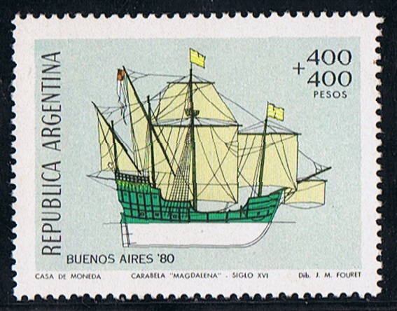 Not much is know about the caravel, where and when built unknown. Tonnage 200 ton, dim. 85 x 25 x 14ft. (draught) Four masts, fore and main mast square rigged, mizzen and Bonaventura mast lateen rigged. She was the flagship of Don Pedro de Mendoza (1487-1537) expedition to the River Plata. Mendoza held a post in the court of Charles V, when he in 1534 made an offer to Emperor Charles V to make an expedition on his own account for the discovery and conquest of Paraguay and the countries on the Rio La Plata. 24 August 1534 Mendoza on board the MAGDALENA and 13 other vessels, with 3000 men set sail from San Lucar, Spain. Receive from the Emperor before sailing 2.000 ducats, with the condition, when he transported to the new founded colonies 1000 colonists and 100 horses, build a road to the Pacific Ocean, erect three forts within two years he would receive 2.000 ducats more. Also he had to take 8 monks, a physician, a surgeon, and an apothecary, but he was forbidden to introduce a lawyer in the colony. He was to have half the treasure of the chiefs killed and nine-tenths of the ransom. Mendoza was made before sailing military governor of all the territory between the Rio de la Plata and the Strait of Magellan. The office of the Governor was also made hereditary. Off the coast of Brazil the fleet was scattered in a heavy storm, and Medoza lieutenant Osario, was assassinated, according to some authorities by the orders of Mendoza himself because of suspected disloyalty. 1535 Mendoza sailed up the Rio de la Plata, and founded Buenos Aires on 02 February 1536. He erected two forts there to defend the place. Pestilence broke out and the natives became unfriendly after ill treatment by the Spaniards. His brother Don Diego led a force against the hostile tribes, but was killed with three-fourths of his men. A general conspiracy of the natives was formed, and Buenos Aires was captured and burned by the natives. Mendoza retired to the forth Sanctus-Spiritus, from where he dispatched Juan de Ayolas to explore the upper part of the river. Another brother, Gonzalo arrived with reinforcements and founded the city of Ascención in Paraguay in 1536. Mendoza, disappointed and with a broken health, embarked on board the MAGDALENA for Spain in 1537, leaving Juan de Ayolas in charge. During the long voyage to Spain he died maniac on board the MAGDALENA on 23 June 1537. The fate of the MAGDALENA is not known. Argentine 1979 400p + 400p sg 1646 Source: mostly copied from http://en.wikipedia.org/wiki/Pedro_de_Mendoza http://famousamericans.net/pedrodemendoza
https://shipstamps.co.uk/forum/viewtopic.php?t=6731
|
|
|
|
Reply |
Message 54 of 66 on the subject |
|
ISLA SAN GIORGIO (VENECIA)=GEORGE LEMAITRE
|
|
|
|
Reply |
Message 55 of 66 on the subject |
|
Dimensions of the Cheops-pyramid (Khufu's pyramid)
Numbers and figures of the Cheops (Khufu) pyramid:
The pyramid of Khufu - Output / performance - Building material - Dimensions of the pyramid - Dimensions in Royal Cubits - Sources
 Cheops-pyramid (pyramid of Khufu) Cheops-pyramid (pyramid of Khufu)
Of the the famous Seven Wonders of the Ancient World the Great Pyramid of Khufu (Cheops) at Giza is the only one still standing. Even for modern men it is amazing how this man-made structure lasted so long.
The Giza pyramids must have made an incredible visual impact - at the edge of the desert three abstract geometrical symbols were rising, huge luminous white triangles reflecting the blinding light of the sun!
The pyramids on the Giza plateau are with 146.59m (Khufu / Cheops) and 143.87m (Khafre / Chefren) respectively the largest, however there are over 30 major pyramids and a myriad of smaller pyramids in Egypt.
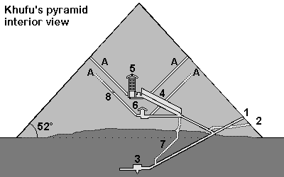
Cheops-Pyramid
1. Entrance 2. Entrance cut by grave robbers 3. Subterranean chamber 4. Grand Gallery 5. King's chamber, relieving chambers, granite portcullis slabs 6. Queen's chamber 7. Shaft 8. Limestone plugging the air shaft A= "Air shafts"
Output / performance
 Detailed calculations how many workers were necessary to build the pyramid Detailed calculations how many workers were necessary to build the pyramid
Overview pyramid building
Builder
------------------- |
|
Khufu (Chuefui-Chnum or Khnum-Khuf, Cheops in Greek) during the 4th dynasty of the old kingdom |
| Time to build |
|
Probably max. 23 years (Khufu reigned from 2551 to 2528 before Christ *). Herodotus writes about 10 years of preparation and 20 years of building (details of the text) |
| Per day |
|
With 2'500'000 stones 342 stones have to be moved daily (working during 365 days a year) or 431 stones daily (working during 290 days a year). |
|
Per minute
|
|
10-hour day: every 2 minutes a stone (34 to 43 per hour)
8-hour day: nearly a stone every minute (42 to 53 stones per hour)
|
| Rule of thumb |
|
| While construction the pyramid the rate of delivery was 1 stone weighting 2.5 tons every minute. |
For our calculations we assume 500 stones a day. This is a rough estimate, assuming a 8-hour day, during 290 days a year, with 20 years to build the pyramid. Also assuming, that more time had to be used for the huge granite blocks for the King's chamber and for the more difficult upper part of the pyramid, where work went slower than in the lower parts. There probably were also other factors delaying the building of the pyramid such as the weather or a temporary shortage of certain building materials.
|
Building materials for the Cheops-pyramid
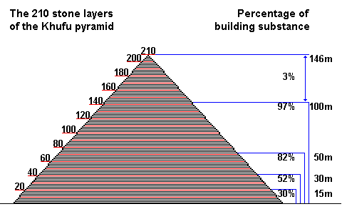
The Khufu-pyramid (Cheops) probably originally had 210 stone layers. At 50m height already 82% of the entire pyramid was built [3].
Quarrying stones for the pyramid
Shipping the stone blocks down the Nile to Giza
Transporting the stone blocks using a sledge on tracks
Löhner's rope roll
Stone blocks
------------------- |
|
2'300'000 stones |
| Casing blocks |
|
115'000 to 200'000 stones or 67'390m³ [1] |
| Total blocks |
|
2'500'000 stones |
| Stone layers |
|
Originally probably 210 stone layers, now only 201 layers [2] |
| Stone size |
|
The stone blocks usually are larger in the lower layers (1.5m = 3 cubit) and smaller in the upper layers. Most are between 1.5 and 2 cubit large (average of 127 x 127 x 71cm). 1 cubit = 0.524m - Details |
| Weight of the stone blocks |
|
With an average density of 2,6 - 2,9 t/m³ the large limestone blocks weighted 6.5 - 10 tons and the smaller ones about 1.3 tons. For all calculations on this website an average weight of 2.5 tons was used. |
| Special blocks |
|
For the King's chamber granite blocks weighting 40 to 50 tons were used |
| Total weight |
|
6'500'000 tons (average weight of a block was about 2.5 tons) |
| Pyramidion |
|
The final stone on the top was a large block in the shape of a pyramid. It was perhaps around 1.5m by 1.5m wide and 1.3m high (about 3 cubits). It was made from white Tura limestone (Turah), granite or perhaps diorite and perhaps gold plated. More information |
| Building materials |
|
Pyramid: Nummulite limestone from quarries about 200-400m south of the pyramid were used for the core stones.
Casing: light white limestone, so called Tura-limestone from quarries from the eastern shores of the Nile
King's chamber: Rose granite from Aswan 900km away
Further materials: Graywacke from the Wadi Hammamat (Eastern desert), basalt from the northern Faiyum
Map of quarries in Egypt
|
Dimensions of the pyramid of Khufu
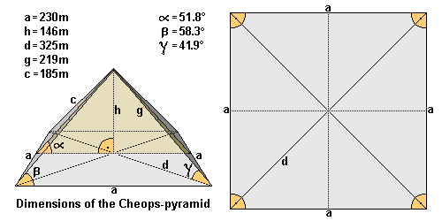
Length (a)
------------------- |
|
The average length of the edge is ~ 230.360m (230,12m = 440 cubits). Northern edge 230.328m - eastern edge 230.369m - southern edge 230.372m - western edge 230.372m. Largest difference is only 4.4cm. [3] |
| Height (h) |
|
Originally 146.59m high (= 280 cubits), the pyramid is now only 138.75m high [7] |
| Diagonal (d) |
|
325.77m |
| Ridge (g) |
|
219m |
| Height of the lateral surface |
|
186.42m |
| Pyramid angle α |
|
51° 50' 40' = inclination of the lateral surface (= 52° rounded off) [3] which corresponds to a seked of 5½ palms |
| Pyramid angle β |
|
58.3° = the two angles of the triangular lateral surface (62° = angle of the apex or tip of the pyramid) - nearly forming an equilateral triangle! |
| Pyramid angle γ |
|
41.9° = angle of the ridge |
| Corner angle |
|
Right angle base with angles from 89° 59' to 90° |
| Base area |
|
53'065.73m² |
| Superficies surface |
|
85'890.69m² |
| Pyramid volume |
|
2'592'968.43m³ including the rock core. This would be a cube with a length of 137.38m. Probable volume of stones used: 2'583'283m³ [1] or 2'326'501m³ [2]. |
| Alignment |
|
Exactly to the north (deviation only 2' 28') |
| Latitude and longitude |
|
N 29° 58’ 44.3830” latitude and E 31° 07’ 57.0194” longitude [5] |
| Altitude |
|
The base of the pyramid of Khufu lies about 60m above sea level, so the tip of the pyramid used to be on 206m above sea level [6]. |
Alignment of the pyramids and controlling the shape of the pyramid (north-south alignment etc.)
Dimensions of the pyramid of Khufu in Egyptian Royal Cubits
 |
Length (a) |
|
440 Royal Cubits |
| Height (h) |
|
280 Royal Cubits |
| Height of the lateral surface (c) |
|
356 Royal Cubits (356.09) |
| Diagonal (d) |
|
622.25 Royal Cubits |
| Ridge (g) |
|
418.56 Royal Cubits |
| Pyramid angle α |
|
51.843° |
| Pyramid angle β |
|
58.3° |
| Pyramid angle γ |
|
41.9° |
| Corner angle |
|
90° |
It is suggested, that the Egyptians used a right angled triangle to determinate the angle of inclination of the pyramid, using the numbers a=11 and b=14 with c=17.8 (or a=22 - b=28 - c= 35.6). This determines a so called seked of 5½ palms.
Alignment of the pyramids and controlling the shape of the pyramid (seked)
Sources
[1] M. Lehner The Complete Pyramids of Egypt
[2] G. Goyon Die Cheops-Pyramide
[3] R. Stadelmann Die grossen Pyramiden von Giza
[4] F. Abitz Der Bau der grossen Pyramide mit einem Schrägaufzug
[5] GPS-coordinates of a brass disk on top of the pyramid of Khufu, Giza Plateau Mapping Project (GPMP)
[6] Maps of the Giza Plateau Mapping Project show the altitude as 60m
[7] D. Arnold Building in Egypt
* Dates according to conventional Egyptian chronology are used in this website. These are based on several list of the dynasties of pharaohs, for example the Aegyptiaca of Manetho of Sebennytos.
https://www.cheops-pyramide.ch/khufu-pyramid/khufu-numbers.html |
|
|
|
Reply |
Message 56 of 66 on the subject |
|
47.6208°N 3.0482°W[41] A large dolmen measuring 12 by 5 m (39 by 16 ft), with a 5 m (16 ft) long broken capstone.[6] It is named after the nearby Chapelle de La Madeleine, which is still used.
 Dolmen of Kercado. Though smaller than St. Michel, older by many centuries before 4800 BC. Dolmen of Kercado. Though smaller than St. Michel, older by many centuries before 4800 BC.
A rare dolmen still covered by its original cairn. South of the Kermario alignments, it is 25 to 30 metres (82–98 ft) wide, 5 m (16 ft) high, and has a small menhir on top. Previously surrounded by a circle of small menhirs 4 m (13 ft) out,[39] the main passage is 6.5 m (21 ft) long and leads to a large chamber where numerous artifacts were found, including axes, arrowheads, some animal and human teeth, some pearls and sherds, and 26 beads of a unique bluish Nephrite gem. It has some Megalithic art carved on its inner surfaces in the form of serpentines and a human-sized double-axe symbol carved in the underside of its main roof slab. In ancient cultures, the axe and more precisely the bi-pennis used to represent the lightning powers of divinity. It was constructed around 4600 BC and used for approximately 3,000 years.[39]
A roughly rectangular mound, with only one capstone remaining. It is aligned east-to-west, with a passage entrance to the south.[42]
On a small hill, has two separate chambers.
(Pixies' mound or Grotte de Grionnec[39]):A group of three dolmens with layout unique in Brittany,[39] once covered by a tumulus. Whereas most groups of dolmens are parallel, these are arranged in a horseshoe. The largest of the three is at the east, 11 metres (36 ft).[38]
 The Crucuno dolmen The Crucuno dolmen
A "classic" dolmen, with a 40-tonne (44-short-ton), 7.6-metre (24 ft 11 in) tablestone resting on pillars roughly 1.8 m (5 ft 11 in) high. Prior to 1900, it was connected by a passage making it 24 m (79 ft) long.[39]
Crucuno stone rectangle
[edit]
47.625°N 3.122°W: A classic 3, 4, 5 rectangle of 21 menhirs varying in height from 0.91 metres (3.0 ft) to 2.4 metres (7.9 ft) that is aligned along its diagonal to the midsummer sunrise. Alexander Thom suggested it measured forty by thirty of his megalithic yards.[43]
 The Manio quadrilateral arrangement The Manio quadrilateral arrangement The Manio "Giant" The Manio "Giant"
There are some individual menhirs and at least one other formation which do not fit into the above categories.
Manio quadrilateral
[edit]
An arrangement of stones to form the perimeter of a large rectangle. Originally a "tertre tumulus" with a central mound, it is 37 m (121 ft) long, and aligned to east of northeast. The quadrilateral is 10 m (33 ft) wide to the east, but only 7 m (23 ft) wide at the west.[44]
47.603°N 3.056°W[45] Near the quadrilateral is a single massive menhir, now known as the "Giant". Over 6.5 m (21 ft) tall, it was re-erected around 1900 by Zacharie Le Rouzic,[39] and overlooks the nearby Kerlescan alignment.[46]
Excavation and analysis
[edit]
 Large upright in the Ménec alignment Large upright in the Ménec alignment
From the 1720s increasing interest was shown in these features.[47] In 1796, for example, La Tour d'Auvergne attributed them to druidic gatherings.[39] In 1805, A. Maudet de Penhoët claimed they represented stars in the sky.[39]
Englishmen Francis Ronalds and Alexander Blair made a detailed survey of the stones in 1834.[48] Ronalds created the first accurate drawings of many of them with his patented perspective tracing instrument, which were printed in a book Sketches at Carnac (Brittany) in 1834.[49]
Miln and Le Rouzic
[edit]
The first extensive excavation was performed in the 1860s by Scottish antiquary James Miln (1819–1881), who reported that by then fewer than 700 of the 3,000 stones were still standing.[50] Towards 1875, Miln engaged a local boy, Zacharie Le Rouzic [fr] (1864–1939), as his assistant, and Zacharie learnt archaeology on the job. After Miln's death, he left the results of his excavations to the town of Carnac, and the James Miln Museum was established there by his brother Robert to house the artifacts. Zacharie became the director of the Museum and, although self-taught, became an internationally recognised expert on megaliths in the region. He too left the results of his work to the town, and the museum is now named Le Musée de Préhistoire James Miln – Zacharie le Rouzic.[51][52]
 The Ménec alignments of some 1,100 stones in 11 columns The Ménec alignments of some 1,100 stones in 11 columns
In 1887, H. de Cleuziou argued for a connection between the rows of stones and the directions of sunsets at the solstices.[39]
Among more recent studies, Alexander Thom worked with his son Archie from 1970 to 1974 to carry out a detailed survey of the Carnac alignments, and produced a series of papers on the astronomical alignments of the stones as well as statistical analysis supporting his concept of the megalithic yard.[51][53] Thom's megalithic yard has been challenged.[54][55]
There are also general theories on the use of the stones as astronomical observatories, as has been claimed for Stonehenge. According to one such theory, the massive menhir at nearby Locmariaquer was linked to the alignments for such a purpose.[15]
 Sheep grazing around the Kerlescan alignment, part of a new management strategy Sheep grazing around the Kerlescan alignment, part of a new management strategy
The Musée de Préhistoire James Miln – Zacharie le Rouzic is at the centre of conserving and displaying the artefacts from the area.[52] It also contains the "world's largest collection [of] prehistoric[al] exhibits"[38] with over 6,600 prehistoric objects from 136 different sites.
The monuments themselves were listed and purchased by the State at the start of the 20th century to protect them against quarrymen, and while this was successful at the time, in the middle of the century, redevelopment, changes to agricultural practices and increasing tourism bringing visitors to the stones led to rapid deterioration. The Ministère de la Culture et de la Communication (Heritage Ministry) re-examined the issue starting in 1984, and subsequently set up the 'Mission Carnac' in 1991 with the aim of rehabilitating and developing the alignments. This involved restricting public access, launching a series of scientific and technical studies, and producing a plan for conservation and development in the area.[56]
As with the megalithic structure of Stonehenge in England, management of the stones can be controversial. Since 1991, the main groups of stone rows have been protected from the public by fences "to help vegetation growth",[38] preventing visits except by organised tours. They are open during winter, however.[57] When James Miln studied the stones in the 1860s, he reported that fewer than 700 of the 3,000 stones were still standing, and subsequent work during the 1930s and 1980s (using bulldozers) rearranged the stones, re-erecting some, to make way for roads or other structures. In 2002, protesters invaded the site, opening the padlocks and allowing tourists free entry.[50] In particular, the group Collectif Holl a gevred (French and Breton for "the everyone-together collective") occupied the visitor centre for the Kermario alignment, demanding an immediate stop to current management plans and local input into further plans.[58]
In recent years, management of the site has also experimented with allowing sheep to graze among the stones, in order to keep gorse and other weeds under control.[59]
In June 2023, 39 menhirs still outside the UNESCO protected site were destroyed to construct a DIY store of the Mr. Bricolage franchise, which obtained a building permit from the local town hall in August 2022. The affected stones are located in the town of Montaubin, separate from the primary tourist locations of Ménec and Kermario, which are situated a little over 1.5km (1 mile) away. The town's mayor, Olivier Lepick, told AFP that he had "followed the law" and pointed to the "low archaeological value" of objects found during checks before the construction process began. He also admitted to being unaware that the site was listed on the Heritage Atlas, despite reportedly presiding over the group that applied for UNESCO status for the prehistoric sites. While Lepick blamed the region's complex zoning situation, the researcher Christian Obeltz claimed that "elected officials in the area and the department are in a hurry to build up anything because once it is classified with UNESCO, it won't be possible anymore". The local Koun Breizh association has decided to lodge a complaint with the public prosecutor of Vannes for willful destruction of sites that relate to archaeological heritage.[60][61][62][63]
https://en.wikipedia.org/wiki/Carnac_stones |
|
|
|
Reply |
Message 57 of 66 on the subject |
|
|
|
|
Reply |
Message 58 of 66 on the subject |
|
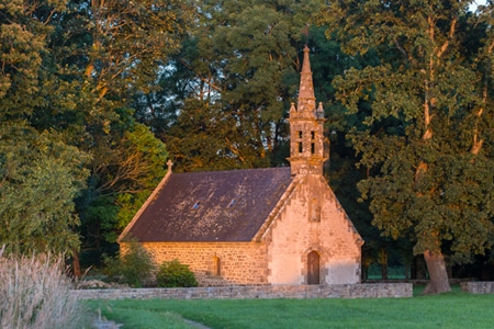
During your holidays in Carnac, discover the town’s religious heritage: its six chapels will take you on a journey through the centuries.
CHAPEL OF St Michel
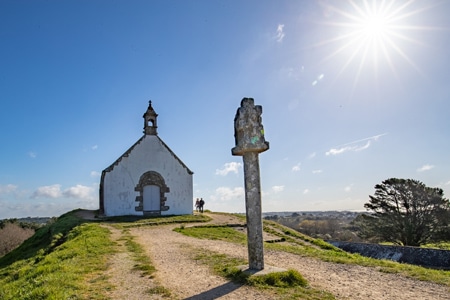
The Chapel of Saint Michel de Carnac was rebuilt around 1813 and again in 1925 on the same plans as the original chapel dating from 1664. It is located on the highest point of the town, the tumulus hill. Below is St Michel devotional fountain. Women whose husbands were at sea, used to sweep the chapel in the direction they wanted to see the wind blow. Then they would to pray at the fountain and drink the water. St Michel’s saints day is in September. There is an orientation table at the high point of the hill.
Climb to the top of the tumulus and admire the breathtaking views of the ocean and islands.
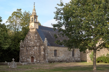
CHAPEL OF St Colomban
The Chapel of Saint Colomban, built in the flamboyant Gothic style, dates from the end of the sixteenth century. It is consecrated to the Irish monk Saint Columba, the patron saint of fools. To the east of the village, with its granite houses, is the fountain of Saint Colomban, which has two drinking pools. The wash house was a meeting place for the village women. South of the village, by the sea, are two chimneys, the remains of a forge.
The chapel is open all year round from 10 am to 6 pm. Entrance is free.
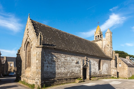
CHAPEL OF Kergroix
The Kergroix chapel dates back to the 16th century, although it was rebuilt in 1951. The Forgiveness of Our Lady of the Cross is celebrated in September. The chapel is open to the public all summer.
CHAPEL OF la Madeleine
The site of the chapel was once a leper colony. The present chapel was rebuilt in 1976. It is open and tended by local people in the summer. The most important service takes place in July. Next to the chapel, you will discover the fountain, the source of which is said to cure fever and skin diseases.
Continue your walk towards the Chapel of Hahon and the Chapel of Coet, both to the North of Carnac.
https://www.carnactourism.co.uk/discover/menhirs-and-heritage/heritage/carnac-chapels |
|
|
|
Reply |
Message 59 of 66 on the subject |
|
Diner des chapelles le 22 Février à 19h30- Salle du Menec à Carnac
https://chapelle-madeleine-carnac.jimdofree.com/ |
|
|
|
Reply |
Message 60 of 66 on the subject |
|
|
|
|
Reply |
Message 61 of 66 on the subject |
|
|
|
|
Reply |
Message 62 of 66 on the subject |
|
|
|
|
Reply |
Message 63 of 66 on the subject |
|
|
|
|
Reply |
Message 64 of 66 on the subject |
|
|
|
|
Reply |
Message 65 of 66 on the subject |
|
|
|
|
Reply |
Message 66 of 66 on the subject |
|
|
|
 First
Previous
52 a 66 de 66
Next First
Previous
52 a 66 de 66
Next
 Last
Last
|
|
| |
|
|
©2025 - Gabitos - All rights reserved | |
|
|